Overview
|
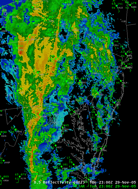
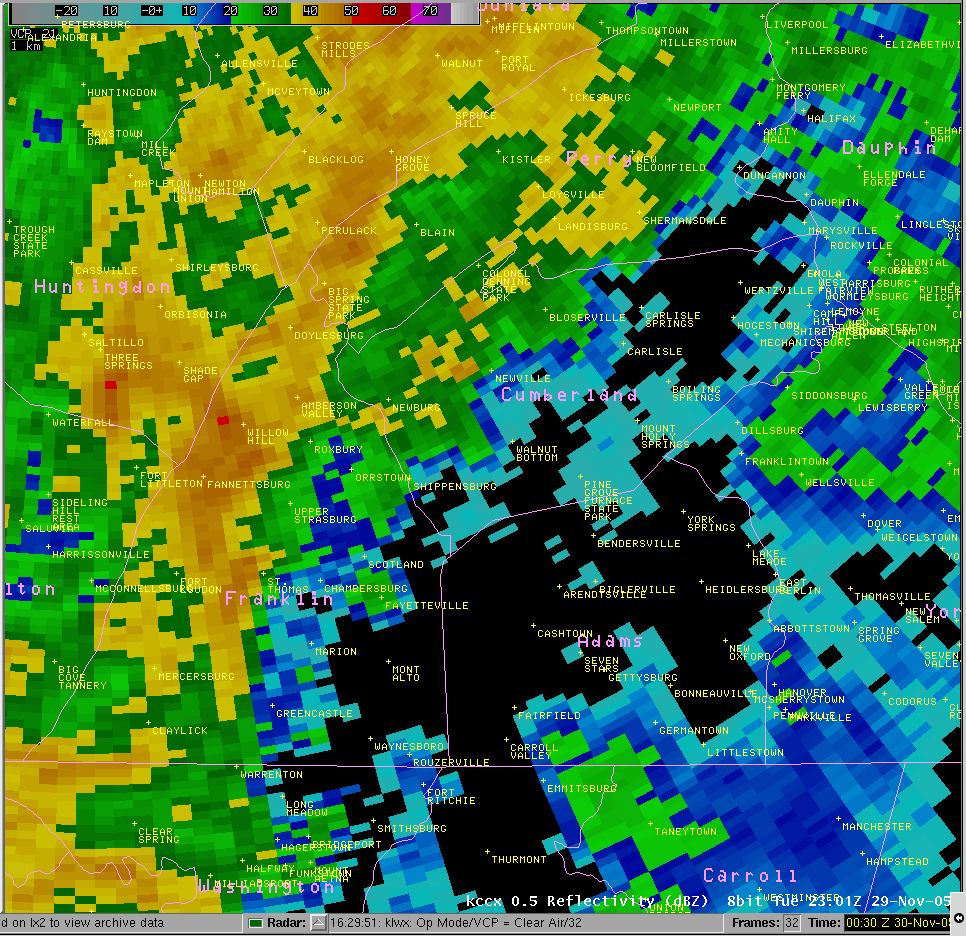
A strong storm system moved eastward into the Mid Atlantic States on Tuesday the 29th, bringing a wide swath of heavy rainfall and also created thunderstorms in the near-record warm air in advance of the cold front. The rains caused flooding in the West Branch of the Susquehanna River Basin and also in the independent tributaries of the Lower Main Stem of the Susquehanna River. A few Severe Thunderstorms also made damage on the evening of the 29th in South-central PA, near Greene Castle, and Gettysburg. |
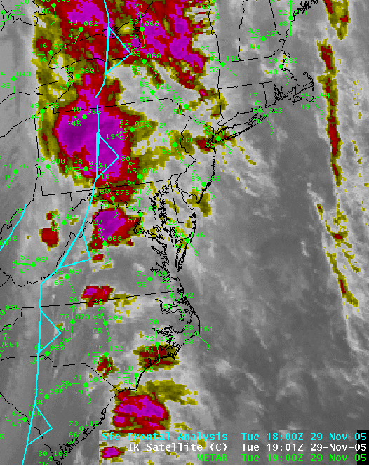 IR Satellite and Fronts |
 |
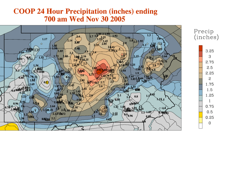 |
| Radar Reflectivity on Nov-29-05 | COOP 24 Hour Precipitation (inches) ending 700 AM Wed Nov 30 2005 |
 |
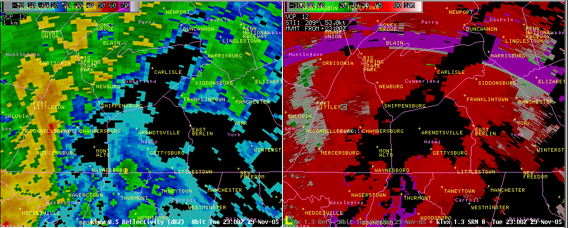 |
| State College WSR 88D - 6:01 pm to 7:28 pm (23:01 UTC 11/29 to 00:28 UTC 11/30) | Sterling Virginia WSR 88D - 6:00 pm to 7:30 pm (23:00 UTC 11/29 to 00:30 UTC 11/30) |
Storm Reports
Preliminary Storm Damage Reports from the evening of the 29th:
NWUS51 KCTP 300122
LSRCTP

PRELIMINARY LOCAL STORM REPORT...CORRECTED
NATIONAL WEATHER SERVICE STATE COLLEGE PA
821 PM EST TUE NOV 29 2005

..TIME...   ...EVENT...      ...CITY LOCATION...     ...LAT.LON...
..DATE...   ....MAG....      ..COUNTY LOCATION..ST.. ...SOURCE....
            ..REMARKS..

0617 PM     TSTM WND DMG     3 N WAYNESBORO          39.80N 77.58W
11/29/2005                   FRANKLIN           PA   EMERGENCY MNGR

            MULTIPLE UTILITY POLES AND WIRES DOWN. POSSIBLE TORNADO.

0640 PM     TSTM WND DMG     BIGLERVILLE             39.93N 77.25W
11/29/2005                   ADAMS              PA   EMERGENCY MNGR

            TREES DOWN.

0655 PM     FLOOD            CLEARFIELD              41.02N 78.44W
11/29/2005                   CLEARFIELD         PA   EMERGENCY MNGR

            3 ROADS TEMPORARILY CLOSED DUE TO HIGH WATER.

0700 PM     TSTM WND DMG     GETTYSBURG              39.83N 77.23W
11/29/2005                   ADAMS              PA   TRAINED SPOTTER

            ONE FOOT THICK TREE LIMB FELL AND DAMAGED HOUSE.

0707 PM     NON-TSTM WND DMG YORK HAVEN              40.11N 76.72W
11/29/2005                   YORK               PA   TRAINED SPOTTER

            ROOF OF MOBILE HOME DAMAGED.

0707 PM     TSTM WND DMG     6 WNW GETTYSBURG        39.86N 77.34W
11/29/2005                   ADAMS              PA   TRAINED SPOTTER

            TREE LIMBS DOWN.

&&

$$
 |
Media use of NWS Web News Stories is encouraged! Please acknowledge the NWS as the source of any news information accessed from this site. |
|


 Send Us a Report