Overview
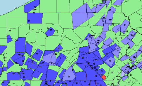
As with the day before (June 12th), a number of thunderstorms fired up in the afternoon heating over Central and Northern PA. These storms then moved south and southwestward into South-Central PA - arriving rom the northeast. This storm movement was very unusual (and the second day in a row like this) - as our predominant/usual flow pattern over Central PA makes most storms move in from the west or south or even sometimes northwest. But, northeast to southwest moving thunderstorms are rare in Central PA.
 |
 |
 |
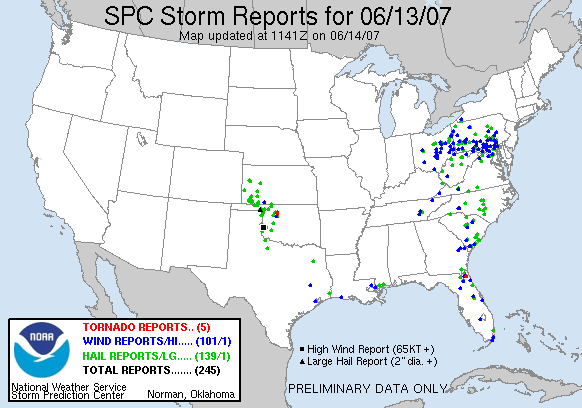
| Graphical plot of severe warnings and preliminary reports. | Severe Weather Reports June 13, 2007 | Visible Satellite Loop 2:45 to 5:55 pm June 13 |
Soundings
Left: KLWX SkewT diagram 7:00 am June 13
Right: KLWX SkewT diagram 1:00 pm June 13
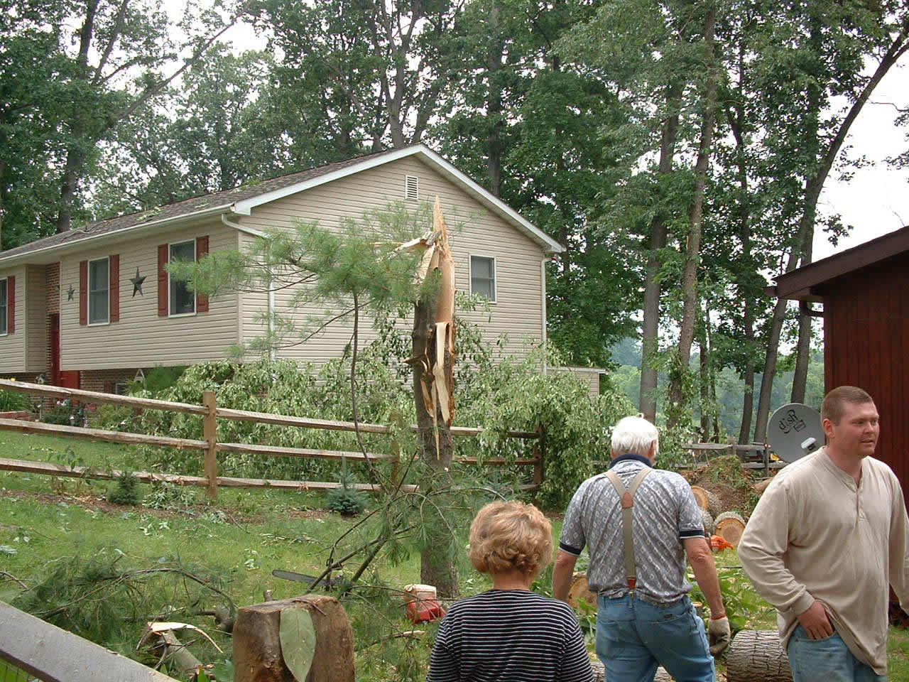
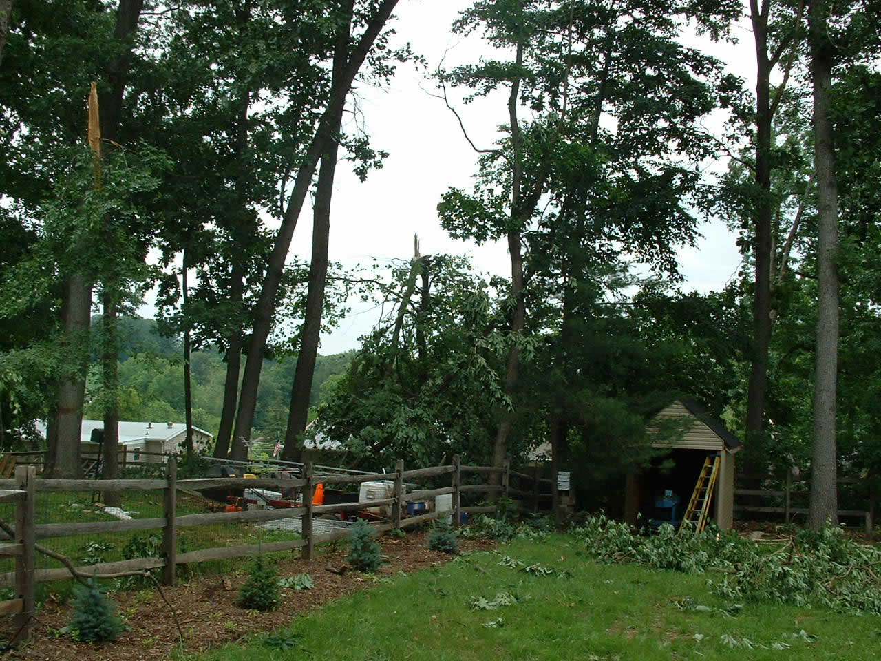
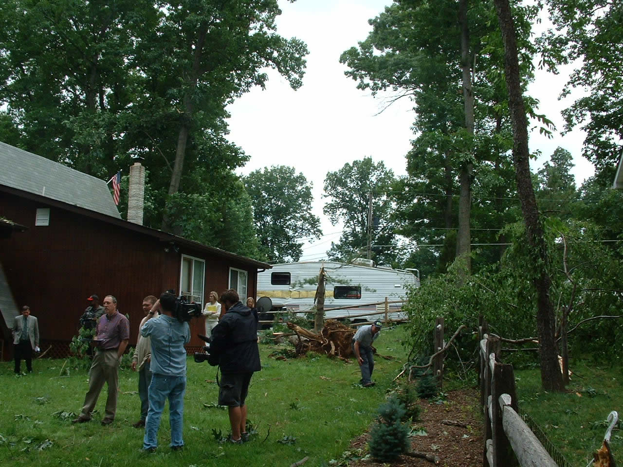
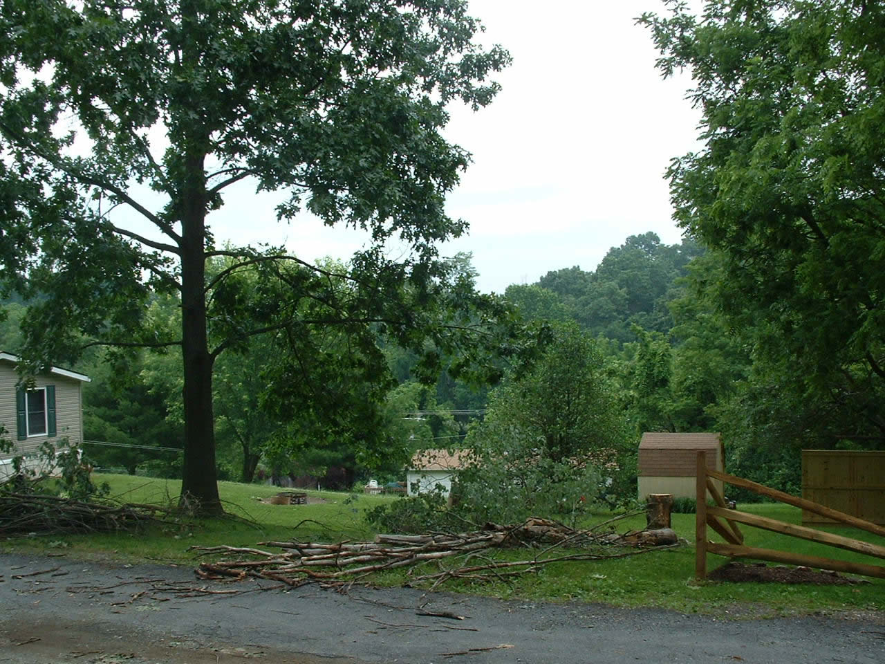
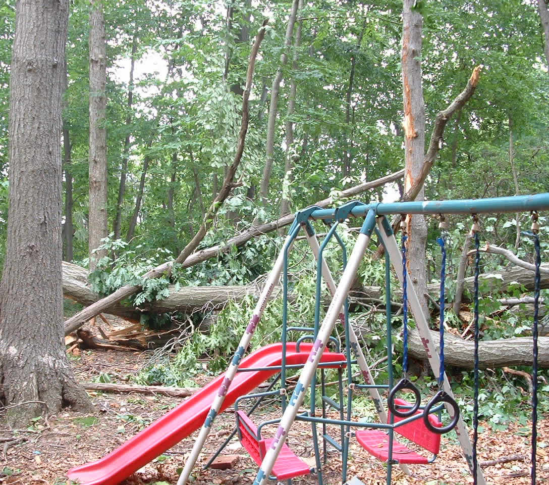
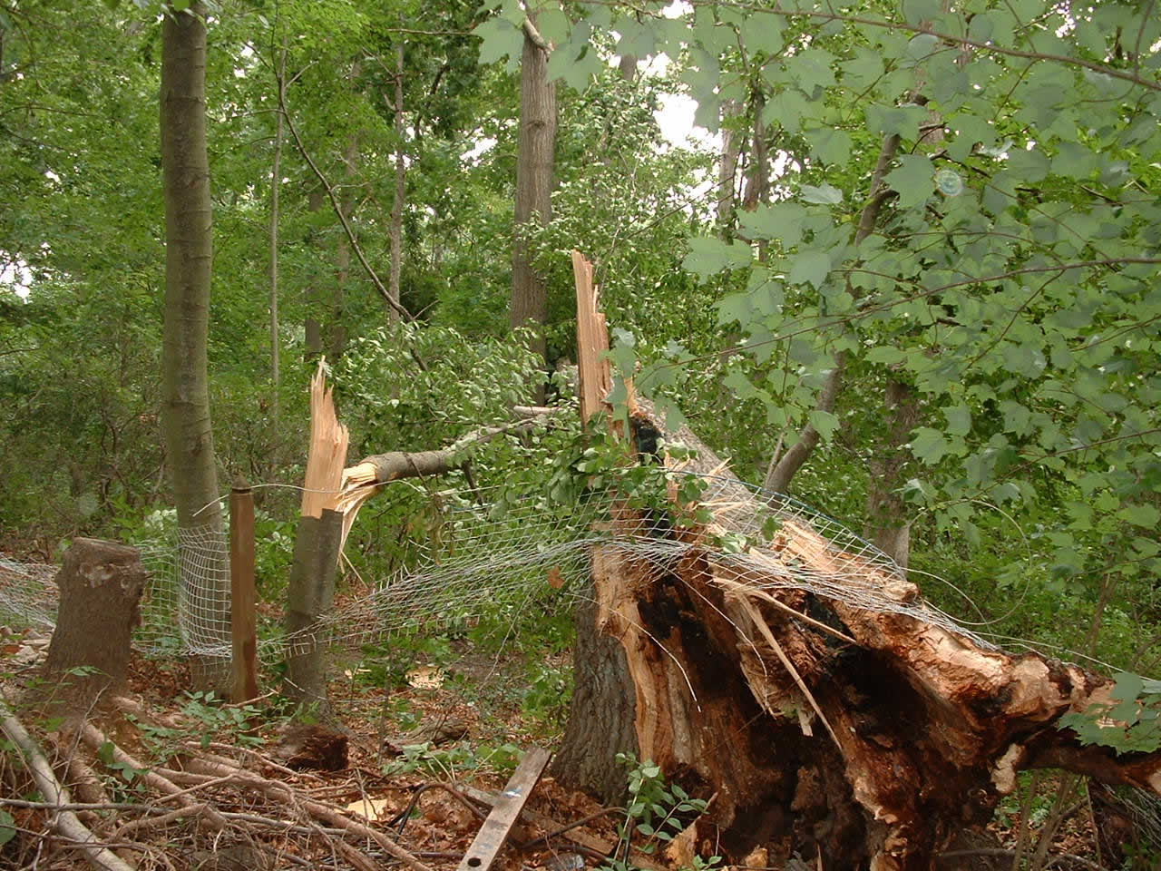
Photos & Video
 |
 |
 |
 |
 |
 |
Radar
 |
 |
 |
 |
| KCCX 0.5 degree Reflectivity and Storm Relative Velocity Bedford and Cambria County Storms 5:11 to 6:27 pm June 13 |
KCCX 0.5 degree Reflectivity and Storm Relative Velocity Dauphin County Storms 3:59 to 4:38 pm June 13 | KCCX 0.5 degree Reflectivity and Storm Relative Velocity Lebanon and Lancaster County Storms 3:38 to 4:25 pm June 13 |
KCCX 0.5 degree Reflectivity and Storm Relative Velocity Northumberland County Storms 2:27 to 3:43 pm June 13 |
 |
 |
| KCCX 0.5 degree Reflectivity and Storm Relative Velocity Lancaster County Storms 3:26 to 4:30 pm June 13 |
KCCX 0.5 degree Reflectivity and Storm Relative Velocity York County Storms |
Storm Reports
A Storm Damage Survey Team traveled to Southeastern York and Lancaster Counties, but found no strong evidence of tornadic damage.
Most of the damage appeared to be downburst/straight-line wind damage.
See the storm damage information statement below:
NOUS41 KCTP 142034
PNSCTP
PAZ065-066-150045-

PUBLIC INFORMATION STATEMENT
NATIONAL WEATHER SERVICE STATE COLLEGE PA
434 PM EDT THU JUN 14 2007

...FINAL DAMAGE SURVEY RESULTS IN YORK COUNTY...

...NON TORNADIC WIND DAMAGE OCCURRED AT THE SUSQUEHANNA TRAILS
SUBDIVISION IN PEACH BOTTOM TOWNSHIP...

THE FOLLOWING IS A FINAL ASSESSMENT FOR THE DAMAGE THAT OCCURRED
ON 6/13/07 AT SUSQUEHANNA TRAILS SUBDIVISION...5 MILES EAST
NORTHEAST OF FAWN GROVE IN PEACH BOTTOM TOWNSHIP.

* EVENT DATE: 6/13/07

* ESTIMATED START TIME: 420 PM TO 430 PM

* EVENT TYPE: STRAIGHT LINE THUNDERSTORM WIND DAMAGE

* EVENT LOCATION: 5 MILES ENE OF FAWN GROVE IN PEACH BOTTOM TOWNSHIP

* PEAK WIND: 75 MPH

* AVERAGE PATH WIDTH: N/A

* PATH LENGTH: N/A

* INJURIES: NONE

* FATALITIES: NONE

* DISCUSSION/DAMAGE:

A SURVEY TEAM CONSISTING OF THE YORK COUNTY EMERGENCY MANAGER
TEAM AND TWO METEOROLOGISTS FROM THE NATIONAL WEATHER SERVICE IN
STATE COLLEGE PA ASSEMBLED THIS AFTERNOON TO ASSESS STORM DAMAGE
FROM WEDNESDAY AFTERNOON.

THE TEAM CONCLUDED THAT STRAIGHT LINE THUNDERSTORM WIND GUSTS WERE
RESPONSIBLE FOR THE RESULTING DAMAGE. DAMAGING WINDS OCCURRED
BETWEEN 420 PM AND 430 PM WEDNESDAY AFTERNOON...DROPPING BETWEEN
15 AND 20 TREES IN THE SUSQUEHANNA TRAILS DEVELOPMENT...WHICH IS
APPROXIMATELY 5 MILES EAST NORTHEAST OF FAWN GROVE IN PEACH BOTTOM
TOWNSHIP.

MINOR RESIDENCE DAMAGE WAS REPORTED TO RAIN GUTTERS...BUT NO
SUBSTANTIAL STRUCTURAL DAMAGE WAS SUSTAINED. THE THUNDERSTORMS
TRAVELED IN AN UNUSUAL DIRECTION...FROM THE NORTHEAST TO THE
SOUTHWEST...DUE TO THE PREVAILING NORTHEAST FLOW ALOFT. THE FALLEN
TREES WERE ALL LAYING TOWARDS THE SOUTHWEST...CONSISTENT WITH
STRAIGHT LINE THUNDERSTORM DOWNBURST WIND DAMAGE.

$$

BUDD/DANGELO/DEVOIR
NWUS51 KCTP 140016
LSRCTP

PRELIMINARY LOCAL STORM REPORT...SUMMARY
NATIONAL WEATHER SERVICE STATE COLLEGE PA
816 PM EDT WED JUN 13 2007

..TIME...   ...EVENT...      ...CITY LOCATION...     ...LAT.LON...
..DATE...   ....MAG....      ..COUNTY LOCATION..ST.. ...SOURCE....
            ..REMARKS..

0157 PM     HAIL             ST. MARYS               41.43N 78.56W
06/13/2007  E0.75 INCH       ELK                PA   PUBLIC

0210 PM     HAIL             5 E HUGHESVILLE         41.24N 76.63W
06/13/2007  E0.88 INCH       LYCOMING           PA   TRAINED SPOTTER

            ESTIMATED WIND GUST OF 35 MPH.

0210 PM     HAIL             2 NNW MUNCY             41.23N 76.80W
06/13/2007  E0.88 INCH       LYCOMING           PA   TRAINED SPOTTER

            NICKEL SIZE HAIL AND 35 MPH WINDS REPORTED IN PENNSDALE
            2.9 MILES NNW OF MUNCY.

0215 PM     TSTM WND DMG     JOHNSONBURG             41.49N 78.68W
06/13/2007                   ELK                PA   EMERGENCY MNGR

            TREE DOWN ON MAIN ST.

0230 PM     HAIL             10 N YOUNGSVILLE        42.00N 79.32W
06/13/2007  E0.75 INCH       WARREN             PA   CO-OP OBSERVER

            LIMBS DOWN. 0.68 INCHES OF RAIN. TEMPERATURE DROPPED FROM
            84 DEGREES TO 54 DEGREES.

0230 PM     HAIL             GRAND VALLEY            41.72N 79.54W
06/13/2007  E0.50 INCH       WARREN             PA   TRAINED SPOTTER

            MARBLE SIZE HAIL AND HEAVY RAIN...0.50 INCHES IN 15
            MINUTES IN GRAND VALLEY.

0255 PM     HAIL             BLOOMSBURG              41.00N 76.46W
06/13/2007  E0.75 INCH       COLUMBIA           PA   PUBLIC

0300 PM     HAIL             GRAND VALLEY            41.72N 79.54W
06/13/2007  E0.25 INCH       WARREN             PA   TRAINED SPOTTER

            0.50 INCHES OF RAIN IN 15 MINUTES.

0306 PM     HAIL             HUMMELS WHARF           40.83N 76.84W
06/13/2007  E0.25 INCH       SNYDER             PA   COUNTY OFFICIAL

            911 OPERATOR REPORTED 1/4 INCH HAIL.

0315 PM     HAIL             GRAND VALLEY            41.72N 79.54W
06/13/2007  E0.50 INCH       WARREN             PA   TRAINED SPOTTER

            MARBLE SIZE HAIL AND HEAVY RAIN...0.50 INCHES IN 15
            MINUTES IN GRAND VALLEY.

0320 PM     HAIL             SANDY RIDGE             40.80N 78.21W
06/13/2007  E0.75 INCH       CENTRE             PA   PUBLIC

0325 PM     TSTM WND DMG     DEER LAKE               40.62N 76.06W
06/13/2007                   SCHUYLKILL         PA   COUNTY OFFICIAL

            911 CENTER REPORTED WIRES AND NUMEROUS LARGE TREES DOWN
            IN DEER LAKE AND PENN TOWNSHIP.

0330 PM     TSTM WND DMG     SUNBURY                 40.86N 76.79W
06/13/2007                   NORTHUMBERLAND     PA   LAW ENFORCEMENT

            MULTIPLE TREES DOWN

0340 PM     HAIL             N BOSWELL               40.16N 79.03W
06/13/2007  E0.25 INCH       SOMERSET           PA   TRAINED SPOTTER

            HAIL COVERED DECK.

0405 PM     HAIL             5 S MILLERSTOWN         40.48N 77.15W
06/13/2007  E0.88 INCH       PERRY              PA   NWS EMPLOYEE

            HAIL OBSERVED ON ROUTE 322.

0409 PM     HAIL             LANCASTER               40.04N 76.30W
06/13/2007  E0.75 INCH       LANCASTER          PA   PUBLIC

            HAIL FELL BETWEEN 354 AND 409 PM

0409 PM     TSTM WND DMG     10 S LANCASTER          39.90N 76.30W
06/13/2007                   LANCASTER          PA   EMERGENCY MNGR

            TREE ON HOUSE ON LAMPETER ROAD IN WEST LAMPETER TWP.

0410 PM     FUNNEL CLOUD     2 NNE HARRISBURG        40.30N 76.87W
06/13/2007                   DAUPHIN            PA   TRAINED SPOTTER

            SPOTTER REPORTED FUNNEL CLOUD NEAR JCT I81/RTE 22 CLOSE
            TO LINGLESTOWN

0411 PM     HAIL             JONESTOWN               40.41N 76.48W
06/13/2007  E0.88 INCH       LEBANON            PA   PUBLIC

            HAIL FELL BETWEEN 356 AND 411 PM

0413 PM     TSTM WND DMG     10 S LANCASTER          39.90N 76.30W
06/13/2007                   LANCASTER          PA   EMERGENCY MNGR

            TREE DOWN ON MILL POINT ROAD.

0415 PM     HAIL             5 SE DALLASTOWN         39.86N 76.56W
06/13/2007  E0.25 INCH       YORK               PA   TRAINED SPOTTER

0415 PM     HAIL             HERSHEY                 40.28N 76.65W
06/13/2007  E0.75 INCH       DAUPHIN            PA   TRAINED SPOTTER

0424 PM     HAIL             HARRISBURG              40.28N 76.88W
06/13/2007  E0.75 INCH       DAUPHIN            PA   PUBLIC

            HAIL BETWEEN 409 AND 424 PM.

0425 PM     HAIL             3 NE CAMP HILL          40.28N 76.88W
06/13/2007  E0.25 INCH       DAUPHIN            PA   TRAINED SPOTTER

            OBSERVER REPORTED HAIL IN THE LOWER SWATARA AREA.

0425 PM     FUNNEL CLOUD     MIDDLETOWN              40.20N 76.73W
06/13/2007                   DAUPHIN            PA   LAW ENFORCEMENT

            PEMA RELAYED REPORT FROM PENNSYLVANIA STATE POLICE OF
            FUNNEL CLOUD IN HERSHEY/MIDDLETOWN AREA.

0430 PM     TSTM WND DMG     3 S CARLISLE            40.16N 77.20W
06/13/2007                   CUMBERLAND         PA   LAW ENFORCEMENT

            TREES DOWN...WIRES DOWN

0431 PM     FUNNEL CLOUD     MECHANICSBURG           40.21N 77.01W
06/13/2007                   CUMBERLAND         PA   COUNTY OFFICIAL

            CUMBERLAND COUNTY 911 RELAYED REPORT FROM PUBLIC.
            OBSERVER WAS IN SOUTHERN CUMBERLAND COUNTY LOOKING SOUTH
            TOWARD YORK COUNTY.

0437 PM     HAIL             ELIZABETHTOWN           40.15N 76.60W
06/13/2007  E0.75 INCH       LANCASTER          PA   PUBLIC

            FELL BETWEEN 422 AND 437 PM

0438 PM     HAIL             1 S GOLDSBORO           40.14N 76.75W
06/13/2007  E0.75 INCH       YORK               PA   PUBLIC

            HAIL FELL AT ETTERS BETWEEN 423 AND 438 PM.

0442 PM     HAIL             HERSHEY                 40.28N 76.65W
06/13/2007  E0.25 INCH       DAUPHIN            PA   PUBLIC

            HAIL FELL BETWEEN 427 AND 442 PM.

0450 PM     FUNNEL CLOUD     MAYTOWN                 40.08N 76.58W
06/13/2007                   LANCASTER          PA   EMERGENCY MNGR

            WOMAN SIGHTED FUNNEL CLOUD ON COFFEE HOUSE LANE IN EAST
            DONEGAL TWP.

0452 PM     HAIL             YORK HAVEN              40.11N 76.72W
06/13/2007  E0.88 INCH       YORK               PA   PUBLIC

            BETWEEN 437 AND 452 PM.

0455 PM     TSTM WND DMG     8 SE ELIZABETHTOWN      40.07N 76.49W
06/13/2007                   LANCASTER          PA   TRAINED SPOTTER

            POSSIBLE TORNADO DAMAGE. TREES DOWN, BARN COLLAPSED AND
            HOUSES DAMAGED BETWEEN MARIETTA AND BAINBRIDGE.

0455 PM     TSTM WND DMG     CASHTOWN                39.88N 77.34W
06/13/2007                   ADAMS              PA   LAW ENFORCEMENT

            TREES DOWN ON WIRES

0505 PM     HAIL             E JOHNSTOWN             40.33N 78.92W
06/13/2007  E0.88 INCH       CAMBRIA            PA   BROADCAST MEDIA

            TELEVISION WEATHERMAN REPORTED HAIL AT STATION IN
            RICHLAND TWP. AT JCT OF RTE 219/SR 256.

0510 PM     TSTM WND DMG     ORBISONIA               40.24N 77.89W
06/13/2007                   HUNTINGDON         PA   LAW ENFORCEMENT

            TREES DOWN NEAR ORBISONIA

0515 PM     TSTM WND DMG     SAXTON                  40.21N 78.25W
06/13/2007                   BEDFORD            PA   LAW ENFORCEMENT

            TREES DOWN

0515 PM     TSTM WND DMG     CHAMBERSBURG            39.93N 77.66W
06/13/2007                   FRANKLIN           PA   LAW ENFORCEMENT

            TREES ON WIRES...ALSO IN ANTRIM TWP AROUND SAME TIME.

0518 PM     TSTM WND DMG     6 SW GETTYSBURG         39.77N 77.31W
06/13/2007                   ADAMS              PA   LAW ENFORCEMENT

            TREES DOWN IN FREEDOM TWP

0520 PM     FLASH FLOOD      10 NNE CHAMBERSBURG     40.07N 77.58W
06/13/2007                   FRANKLIN           PA   TRAINED SPOTTER

            OBSERVER REPORTED 2 ROADS FLOODED IN SHIPPENSBURG. WIND
            GUSTS BETWEEN 30 AND 40 MPH BETWEEN 513 AND 520 PM BUT NO
            WIND DAMAGE.

0550 PM     TSTM WND DMG     EVERETT                 40.01N 78.37W
06/13/2007                   BEDFORD            PA   LAW ENFORCEMENT

            TREES DOWN

0620 PM     HAIL             5 S RAINSBURG           39.82N 78.52W
06/13/2007  E0.75 INCH       BEDFORD            PA   FIRE DEPT/RESCUE

            REPORTED BY FIRE POLICE IN CHEYNESVILLE

0620 PM     TSTM WND DMG     HYNDMAN                 39.82N 78.72W
06/13/2007                   BEDFORD            PA   LAW ENFORCEMENT

            TREES DOWN


&&

$$

MMD
 |
Media use of NWS Web News Stories is encouraged! Please acknowledge the NWS as the source of any news information accessed from this site. |
|


 Send Us a Report