Overview
|
An impressive January thaw culminated in a number of near-record or record high temperatures on Monday and Tuesday, January 7-8, 2008, throughout central Pennsylvania. Last week's "January Thaw" feature advertised the potential for record high temperatures nearly one week in advance. |
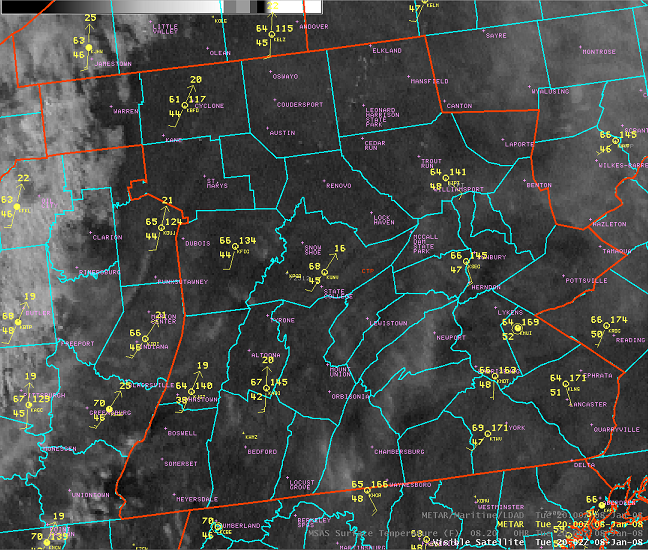 3PM EST temperatures (in the 60s) are shown from the afternoon of January 8, 2008. |
Temperature and Records
Monday, January 7, 2008
| Location | High | (Old) Record High | (Old) Record Year |
| Altoona (KAOO) | 67 |
64 |
1998 |
| Bradford (KBFD) | 56 |
44 |
1961 |
| Johnstown (KJST) | 61 |
70 |
1937 |
| Lancaster (Coop) | 62 |
65 |
1998 |
| Middletown (KMDT) | 65 |
64 |
1998 |
| State College (Coop) | 66 |
65 |
1998 |
| Williamsport (KIPT) | 58 |
61 |
1998 |
| York (KTHV) | 68 |
*67 |
1998 |
* Coop Observer 3 SSW York (Pump Station), as KTHV records only go back to 2000.
Tuesday, January 8, 2008
| Location | High | (Old) Record High | (Old) Record Year |
| Altoona (KAOO) | 67 |
65 |
1949 |
| Bradford (KBFD) | 61 |
52 |
1965 |
| Johnstown (KJST) | 65 |
65 |
1965 |
| Lancaster (Coop) | 66 |
64 |
1998 |
| Middletown (KMDT) | 67 |
68 |
1998 |
| State College (Coop) | 67 |
66 |
1998 |
| Williamsport (KIPT) | 65 |
64 |
1998 |
| York (KTHV) | 70 |
*70 |
1930 |
* Coop Observer 3 SSW York (Pump Station), as KTHV records only go back to 200
 |
Media use of NWS Web News Stories is encouraged! Please acknowledge the NWS as the source of any news information accessed from this site. |
|


 Send Us a Report