Overview
|
This Alberta Clipper acted VERY much like we thought it would. The heaviest snow fell in the Laurels, and along and south of the Turnpike. Locations north of i-80 had very little snow at all. A heavy burst of snow over Adams and York Counties (some reports of 2-4 inches) in the evening hours on Wed made things interesting there, though. |
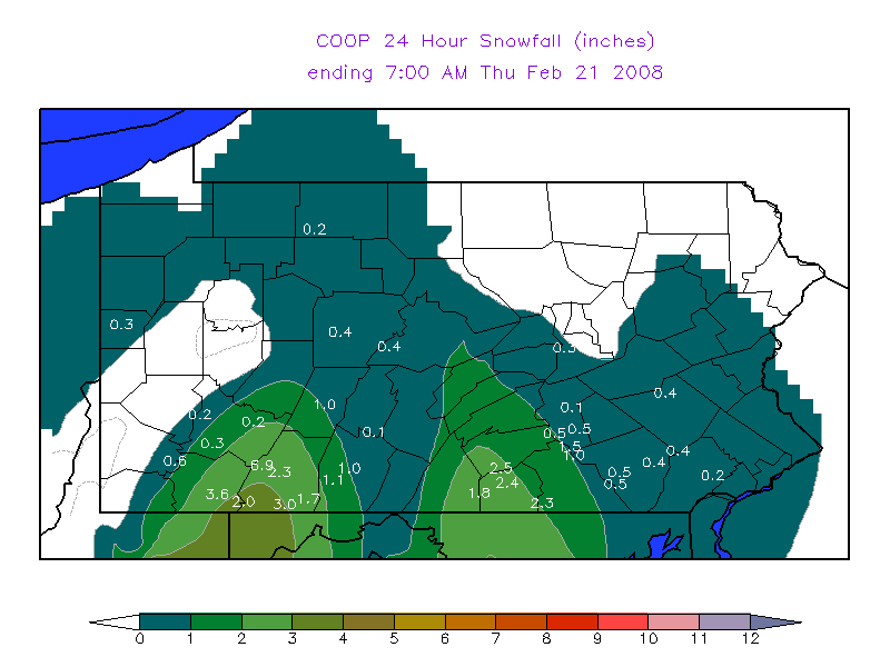 24-Hour Snowfall totals Wed morn-Thur Morn |
Storm Reports
000
NOUS41 KCTP 210340
PNSCTP
PAZ004>006-010>012-017>019-024>028-033>037-041-042-045-046-049>053-
056>059-063>066-211534-

PUBLIC INFORMATION STATEMENT
SPOTTER REPORTS
NATIONAL WEATHER SERVICE STATE COLLEGE PA
1040 PM EST WED FEB 20 2008

THE FOLLOWING ARE UNOFFICIAL OBSERVATIONS TAKEN DURING THE PAST 8 HOURS
FOR THE STORM THAT HAS BEEN AFFECTING OUR REGION.  APPRECIATION IS EXTENDED
TO HIGHWAY DEPARTMENTS...COOPERATIVE OBSERVERS...SKYWARN SPOTTERS
AND MEDIA FOR THESE REPORTS.  THIS SUMMARY IS ALSO AVAILABLE ON OUR
HOME PAGE AT WEATHER.GOV/CTP

********************STORM TOTAL SNOWFALL********************

LOCATION          STORM TOTAL    TIME/DATE    COMMENTS
                     SNOWFALL       OF
                     (INCHES)   MEASUREMENT


PENNSYLVANIA

...ADAMS COUNTY...
   NEW OXFORD             4.0   653 PM  2/20
   NEW OXFORD             3.0   540 PM  2/20
   ABBOTTSTOWN            2.8   607 PM  2/20

...CUMBERLAND COUNTY...
   CARLISLE               2.9   613 PM  2/20
   CAMP HILL              2.5   502 PM  2/20
   CAMP HILL              1.5   706 PM  2/20
   CARLISLE               1.5   412 PM  2/20

...DAUPHIN COUNTY...
   HARRISBURG             1.0   732 PM  2/20

...FRANKLIN COUNTY...
   UPPER STRASBURG        2.0   545 PM  2/20

...LANCASTER COUNTY...
   MILLERSVILLE           0.5   725 PM  2/20

...SOMERSET COUNTY...
   MEYERSDALE             5.2   508 PM  2/20
   BOSWELL                4.7   423 PM  2/20

...YORK COUNTY...
   DOVER                  4.0   600 PM  2/20
   YORK                   3.8   710 PM  2/20
   YORK                   3.2   548 PM  2/20
   YORK                   2.5   402 PM  2/20
   DALLASTOWN             2.0   708 PM  2/20
   YORK                   2.0   432 PM  2/20
   SEVEN VALLEYS          1.5   533 PM  2/20
   DALLASTOWN             0.5   348 PM  2/20

$$
 |
Media use of NWS Web News Stories is encouraged! Please acknowledge the NWS as the source of any news information accessed from this site. |
|


 Send Us a Report