Overview
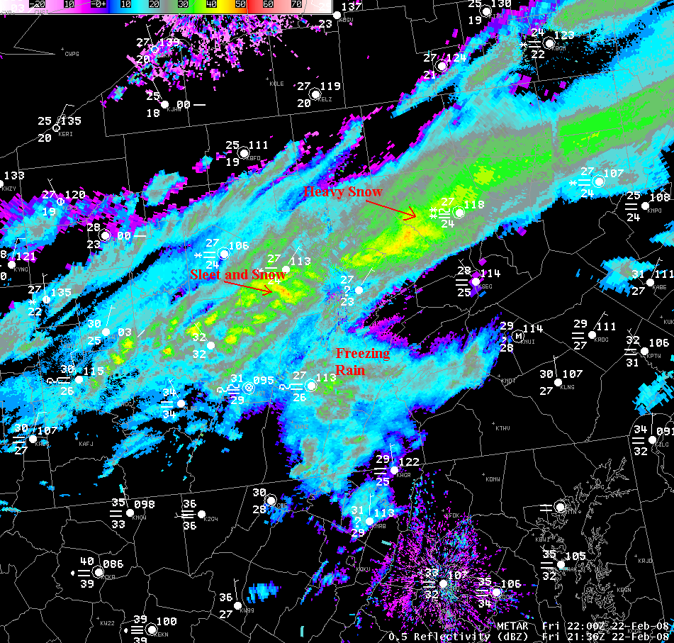
A long-duration Winter Storm affected the entire region from late Thursday Night into Friday Night. Many locations picked up 2-4 inches of snow before Noon on Friday. Sleet and Freezing Rain started to occur across the Southern Tier during the morning on Friday as well, which ended the snowfall there. A band of heavier snow and some sleet sat across the north-central mountains most of the day.
 |
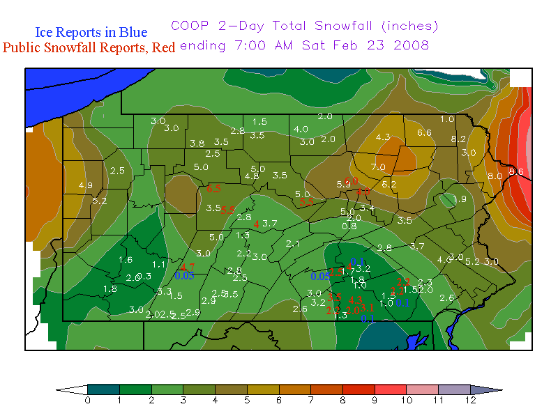 |
| Radar Mosaic around 430 PM EST, with many enhanced areas of precipitation. | 36 Hour Snowfall reports from 7PM Feb 21st thru 7AM on the 23rd, 2008 |
Storm Reports
|
    ** 36 Hour Snowfall totals (7PM 21st thru 7AM 23rd): **

LOCATION          STORM TOTAL    TIME/DATE    COMMENTS
                     SNOWFALL       OF
                     (INCHES)   MEASUREMENT


PENNSYLVANIA

...ADAMS COUNTY...
   YORK SPRINGS            3.5   742 AM    2/22   PUBLIC REPORT
   BIGLERVILLE             3.2   700 AM    2/22   COOP REPORT
   NEW OXFORD              2.2   947 AM    2/22   PUBLIC RPT
   HANOVER                 1.3   700 AM    2/22   COOP REPORT

...BEDFORD COUNTY...
   EVERETT                 3.5   700 AM    2/22   COOP REPORT
   BUFFALO MILLS           2.9   700 AM    2/22   COOP REPORT
   SAXTON                  2.5   700 AM    2/22   COOP REPORT
   WOLFSBURG               2.3   700 AM    2/22   COOP REPORT

...BLAIR COUNTY...
   ALTOONA                 2.8   700 AM    2/23   COOP REPORTS
   TYRONE                  1.3   700 AM    2/23   COOP REPORTS
   WILLIAMSBURG            2.2   700 AM    2/23   COOP REPORTS

...CAMBRIA COUNTY...
   JOHNSTOWN               4.7   900 AM    2/22   PUBLIC RPT
   PRINCE GALLITZIN SP     5.0   700 AM    2/23   COOP REPORTS
   EBENSBURG               3.0   700 AM    2/23   COOP REPORTS

...CAMERON COUNTY...
   SINNEMAHONING           4.8   700 AM    2/23   COOP REPORTS
   STEVENSON DAM           5.0   700 AM    2/23   COOP REPORTS

...CENTRE COUNTY...
   STATE COLLEGE           3.7   700 AM    2/23   COOP REPORTS
   PHILIPSBURG 2S          2.8   700 AM    2/23   COOP REPORTS
   PARK FOREST             5.0   700 AM    2/23   NWS EMPLOYEE
   STORMSTOWN              4.0   135 PM    2/22   PUBLIC REPORT

...CLEARFIELD COUNTY...
   PENFIELD                6.5   700 AM    2/23   PUBLIC REPORT
   HYDE                    5.5   400 PM    2/22   PENN DOT

...CLINTON COUNTY...
   LOCK HAVEN              5.0   700 AM    2/23   COOP REPORTS
   LOCK HAVEN              5.5   750 PM    2/22   PUBLIC REPORT

...COLUMBIA COUNTY...
   BENTON                  6.2   700 AM    2/23   COOP REPORTS

...CUMBERLAND COUNTY...
   CAMP HILL               2.5   545 PM    2/22   PUBLIC REPORT
   PINE GROVE FURNACE      3.0   700 AM    2/23   COOP REPORTS

...DAUPHIN COUNTY...
   HARRISBURG              4.0   959 AM    2/23   PUBLIC REPORT
   HARRISBURG 1NE          1.7   700 AM    2/23   COOP REPORTS
   HERSHEY                 3.2   700 AM    2/23   COOP REPORTS

...ELK COUNTY...
   RIDGWAY                 5.0   700 AM    2/23   COOP REPORTS

...FRANKLIN COUNTY...
   UPPPER STRASBURG        3.3   700 AM    2/23   COOP REPORTS
   SOUTH MOUNTAIN          2.6   700 AM    2/22   COOP REPORTS

...LANCASTER COUNTY...
   GLEN MOORE              2.7   700 AM    2/23   COOP REPORTS
   MILLERSVILLE            1.5   700 AM    2/23   COOP REPORTS
   LANCASTER               2.2   838 AM    2/22   PUBLIC REPORT
   LITITZ                  2.2   753 AM    2/22   PUBLIC REPORT
   NEW HOLLAND             1.5   700 AM    2/23   COOP REPORTS

...LYCOMING COUNTY...
   WILLIAMSPORT            5.9   700 AM    2/23   COOP REPORTS
   WILLIAMSPORT            6.0   926 AM    2/23   PUBLIC REPORT
   WILLIAMSPORT            5.5   800 AM    2/23   PUBLIC REPORT
   MONTGOMERY              3.9   857 PM    2/22   PUBLIC REPORT
   MUNCY                   4.0   633 PM    2/22   PUBLIC REPORT

...MCKEAN COUNTY...
   CLERMONT                3.5   700 AM    2/23   COOP REPORTS
   KANE                    3.8   700 AM    2/23   COOP REPORTS
   PORT ALLEGHENY          2.8   700 AM    2/23   COOP REPORTS

...MIFFLIN COUNTY...
   LEWISTOWN               2.1   700 AM    2/23   COOP REPORTS

...MONTOUR COUNTY...
   DANVILLE                3.4   700 AM    2/23   COOP REPORTS

...NORTHUMBERLAND COUNTY...
   SHAMOKIN                4.5   950 AM    2/22   PUBLIC RPT
   MONTANDON               2.0   500 PM    2/22   PUBLIC REPORT

...POTTER COUNTY...
   GALETON                 4.0  1000 AM    2/23   COOP REPORTS

...SCHUYLKILL COUNTY...
   MAHANOY CITY            3.5   700 AM    2/23   COOP REPORTS

...SULLIVAN COUNTY...
   LAPORTE                 7.0   700 AM    2/23   COOP REPORTS

...TIOGA COUNTY...
   COVINGTON               3.0   700 AM    2/23   COOP REPORTS
   SABINSVILLE             4.0   700 AM    2/23   COOP REPORTS

...UNION COUNTY...
   LEWISBURG               5.0   700 AM    2/23   COOP REPORTS

...WARREN COUNTY...
   CHANDLERS VALLEY        3.0   700 AM    2/23   COOP REPORTS
   WARREN                  3.0   700 AM    2/23   COOP REPORTS

...YORK COUNTY...
   DALLASTOWN              3.1   650 PM    2/22   PUBLIC REPORT
   YORK                    4.3  1016 AM    2/22   PUBLIC REPORT
   SEVEN VALLEYS           1.8  1058 AM    2/22   PUBLIC REPORT
   SPRING GROVE            2.0   110 PM    2/22   PUBLIC REPORT

ICE (FREEZING RAIN) REPORTS:

...CAMBRIA COUNTY...
   JOHNSTOWN               0.05  900 AM    2/22   PUBLIC REPORT

...CUMBERLAND COUNTY...
   CAMP HILL               0.05  545 PM    2/22   PUBLIC REPORT

...DAUPHIN COUNTY...
   HARRISBURG              0.1   959 AM    2/23   PUBLIC REPORT

...LANCASTER COUNTY...
   MILLERSVILLE            0.1   900 PM    2/22   PUBLIC REPORT

...YORK COUNTY...
   DALLASTOWN              0.1   650 PM    2/22   PUBLIC REPORT
|
 |
Media use of NWS Web News Stories is encouraged! Please acknowledge the NWS as the source of any news information accessed from this site. |
|


 Send Us a Report