Overview
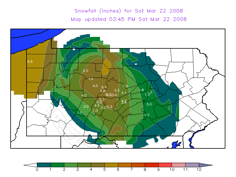
An Alberta Clipper moved through the State on Friday Night and Saturday Morning (March 22nd), producing a stripe of snow from DuBois to State College.
 |
 |
| Snowfall Map ending 10 AM EDT 22Mar2008 | Visible Satellite Picture on March 23rd |
Storm Reports
PUBLIC INFORMATION STATEMENT
SPOTTER REPORTS
NATIONAL WEATHER SERVICE STATE COLLEGE PA
130 PM EDT SAT MAR 22 2008
THE FOLLOWING ARE UNOFFICIAL OBSERVATIONS TAKEN DURING THE PAST 24
HOURS FOR THE STORM THAT HAS BEEN AFFECTING OUR REGION.
APPRECIATION IS EXTENDED TO HIGHWAY DEPARTMENTS...COOPERATIVE
OBSERVERS...SKYWARN SPOTTERS AND MEDIA FOR THESE REPORTS.  THIS
SUMMARY IS ALSO AVAILABLE ON OUR HOME PAGE AT WEATHER.GOV/CTP
***********************STORM TOTAL SNOWFALL***********************
LOCATION          STORM TOTAL    TIME/DATE     COMMENTS
                     SNOWFALL       OF
                     (INCHES)   MEASUREMENT

PENNSYLVANIA
...BLAIR COUNTY...
   BELLWOOD               6.0   900 AM  3/22   SPOTTER
   ALTOONA                4.5   900 AM  3/22   NWS EMPLOYEE
   WILLIAMSBURG           3.2   700 AM  3/22   COOP REPORT
   TYRONE                 2.0   700 AM  3/22   COOP REPORT
   NEWRY                  1.0   700 AM  3/22   COCORAHS
...CAMBRIA COUNTY...
   PRINCE GALLITZIN SP    4.5   700 AM  3/22   COOP REPORT
   EBENSBURG              3.0   600 AM  3/22   PENNDOT
   JOHNSTOWN              1.0   600 AM  3/22   PUBLIC
...CENTRE COUNTY...
   BELLEFONTE             5.5   800 AM  3/22   COCORAHS
   STORMSTOWN             5.3   930 AM  3/22   SPOTTER
   PORT MATILDA           5.2   700 AM  3/22   NWS EMPLOYEE
   PARK FOREST            4.3   800 AM  3/22   NWS EMPLOYEE
   SPRING MILLS           4.1   900 AM  3/22   PUBLIC
   STATE COLLEGE 3NW      4.0   700 AM  3/22   COCORAHS
   PHILIPSBURG            3.8   700 AM  3/22   COOP REPORT
   PENN STATE UNIV        3.5   800 AM  3/22   PSU MET DEPT
   STATE COLLEGE          3.0   600 AM  3/22   NWS OFFICE
...CLEARFIELD COUNTY...
   PENFIELD               7.0   800 AM  3/22   PUBLIC
   KYLERTOWN              5.0   600 AM  3/22   PENNDOT
   CLEARFIELD             4.0   600 AM  3/22   PENNDOT
   PATCHINVILLE           4.0   600 AM  3/22   PENNDOT
...CLINTON COUNTY...
   LAMAR                  1.5   600 AM  3/22   PENNDOT
...DAUPHIN COUNTY...
   ELIZABETHVILLE         3.0   700 AM  3/22   PUBLIC
   HARRISBURG             1.0   945 AM  3/22   PUBLIC
...ELK COUNTY...
   RIDGWAY                2.0   700 AM  3/22   COOP REPORT
...HUNTINGDON COUNTY...
   HUNTINGDON             5.3   700 AM  3/22   COOP REPORT
...MIFFLIN COUNTY...
   BURNHAM                3.7   800 AM  3/22   COCORAHS
   LEWISTOWN              2.8   700 AM  3/22   COOP REPORT
...NORTHUMBERLAND COUNTY...
   SUNBURY                1.0   700 AM  3/22   COOP REPORT
...SNYDER COUNTY...
   SELINSGROVE            1.0   700 AM  3/22   COOP REPORT
...UNION COUNTY...
   MIFFLINBURG            1.8   700 AM  3/22   NWS EMPLOYEE
$$
 |
Media use of NWS Web News Stories is encouraged! Please acknowledge the NWS as the source of any news information accessed from this site. |
|


 Send Us a Report