Overview
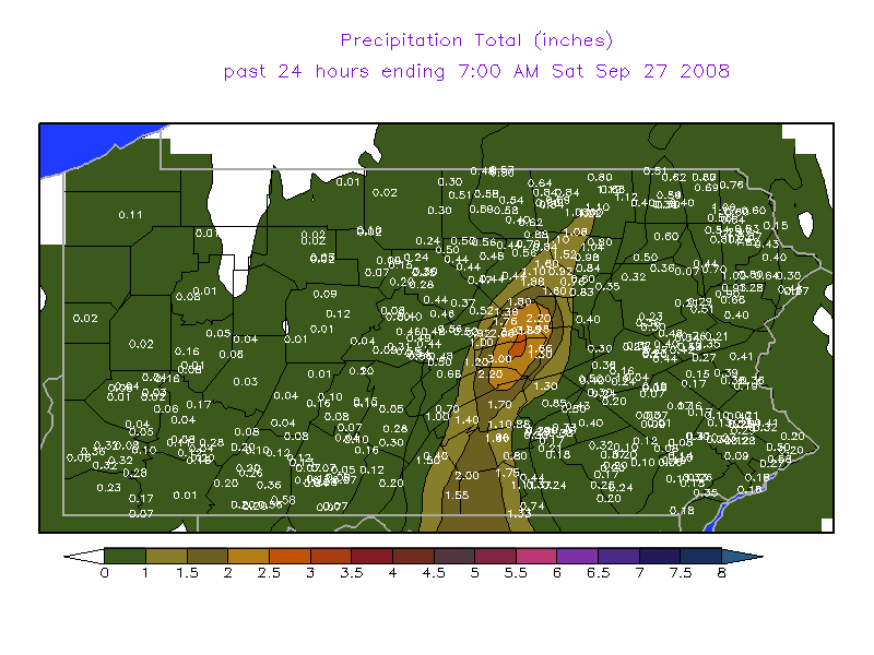
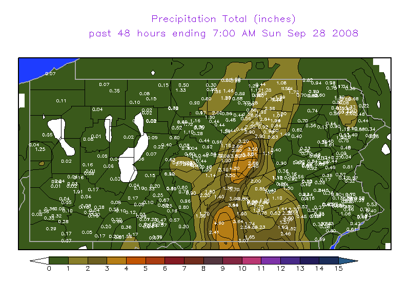
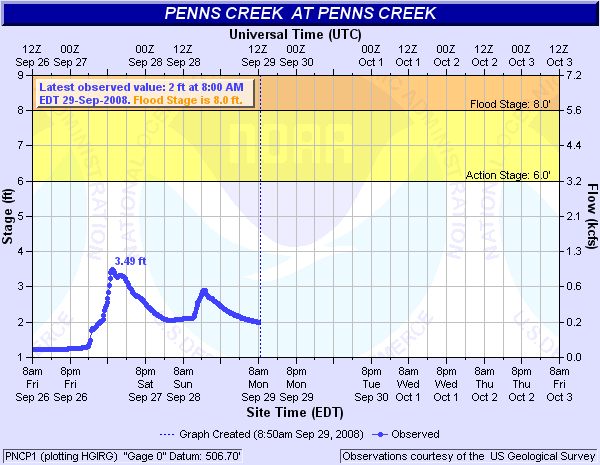
Heavy rain, due to training showers and thunderstorms, fell along and just to the west of the Main Stem Susquehanna River during the early morning of September 27th, 2008. Moderate to heavy rain continued through the day on Saturday, and into the morning on Sunday the 28th. Some locations in and close to Union County (Lewisburg and Mifflinburg) had 3 to 4 inches of rain on Saturday morning, and another inch or so through Sunday morning (the 28th). This rain was the first significant rainfall since the 9th and 10th of the month for most of that area. This recent dryness helped to keep the rivers and streams from overflowing. Only very minor reports of flooding were received.Maps & Figures
 |
 |
 |
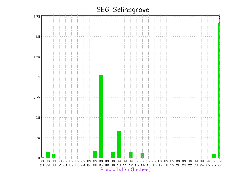 |
| Precipitation Totals Ending 7:00AM September 27 | Precipitation Totals Ending 7:00AM September 28 | Flood Stage of Penns Creek | Precipitation Graph for Selinsgrove |
Radar
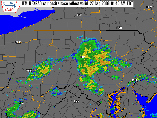 |
| IEM NEXRAD Composite Base Reflectivity |
Storm Reports
PUBLIC INFORMATION STATEMENT
SPOTTER REPORTS
NATIONAL WEATHER SERVICE STATE COLLEGE PA
150 PM EDT SUN SEP 28 2008

THE FOLLOWING ARE UNOFFICIAL STORM TOTAL RAINFALL ACCUMULATIONS
FOR AMOUNTS GREATER THAN 1.00 INCH OVER THE PAST 2 DAYS FROM
THE NATIONAL WEATHER SERVICE. THANKS TO PUBLIC AND COOP SPOTTERS
FOR YOUR REPORTS. THIS SUMMARY CAN ALSO BE FOUND ON OUR HOME
PAGE AT HTTP://WWW.NWS.NOAA.GOV/CTP

********************STORM TOTAL RAINFALL********************

LOCATION          STORM TOTAL    TIME/DATE    COMMENTS
                     RAINFALL       OF
                     (INCHES)   MEASUREMENT


PENNSYLVANIA

...ADAMS COUNTY...
   HANOVER               3.43   700 AM  9/28 COOP REPORT

...BEDFORD COUNTY...
   WOLFSBURG             1.31   700 AM  9/28 COOP REPORT

...BLAIR COUNTY...
   TYRONE                1.44   700 AM  9/28 COOP REPORT

...CAMERON COUNTY...
   STEVENSON DAM         1.40   700 AM  9/28 COOP REPORT

...CENTRE COUNTY...
   STATE COLLEGE         1.61   700 AM  9/28 COOP REPORT

...COLUMBIA COUNTY...
   BENTON                1.52   700 AM  9/28 COOP REPORT

...DAUPHIN COUNTY...
   HERSHEY               1.40   700 AM  9/28 COOP REPORT
   HARRISBURG            2.05   700 AM  9/28 COOP REPORT
   HARRISBURG 1NE        1.79   700 AM  9/28 COOP REPORT
   DEHART DAM            1.05   700 AM  9/28 COOP REPORT

...FRANKLIN COUNTY...
   UPPPER STRASBURG      1.50   700 AM  9/28 COOP REPORT
   SOUTH MOUNTAIN        2.87   700 AM  9/28 COOP REPORT

...HARFORD COUNTY...
   CONOWINGO DAM         1.16   700 AM  9/28 COOP REPORT

...HUNTINGDON COUNTY...
   RAYSTOWN LAKE         1.06   700 AM  9/28 COOP REPORT

...LANCASTER COUNTY...
   SAFE HARBOR           2.15   700 AM  9/28 COOP REPORT
   MILLERSVILLE          1.76   700 AM  9/28 COOP REPORT
   HOLTWOOD              2.61   700 AM  9/28 COOP REPORT

...LYCOMING COUNTY...
   WILLIAMSPORT          2.91   700 AM  9/28 COOP REPORT

...MONTOUR COUNTY...
   DANVILLE              1.21   700 AM  9/28 COOP REPORT

...SCHUYLKILL COUNTY...
   MAHANOY CITY          1.05   700 AM  9/28 COOP REPORT
   PINE GROVE            1.00   700 AM  9/28 COOP REPORT

...SNYDER COUNTY...
   SELINSGROVE           2.44   700 AM  9/28 COOP REPORT

...SOMERSET COUNTY...
   GLENCOE               1.17   700 AM  9/28 COOP REPORT

...SULLIVAN COUNTY...
   LAPORTE               2.03   700 AM  9/28 COOP REPORT

...TIOGA COUNTY...
   WELLSBORO             1.51   700 AM  9/28 COOP REPORT
   COWANESQUE DAM        1.08   700 AM  9/28 COOP REPORT
   SABINSVILLE           1.36   700 AM  9/28 COOP REPORT

...UNION COUNTY...
   LEWISBURG             3.32   700 AM  9/28 COOP REPORT

...YORK COUNTY...
   YORK HAVEN            1.79   700 AM  9/28 COOP REPORT
 |
Media use of NWS Web News Stories is encouraged! Please acknowledge the NWS as the source of any news information accessed from this site. |
|


 Send Us a Report