Overview
|
A storm moved across the Ohio Valley on the 27th and spread a wintry mix of precipitation into Pennsylvania late on the 27th. The precipitation stayed almost all snow in Northern PA, but turned to a sloppy mix of sleet and freezing rain in the rest of the region. Many areas were covered with light to moderate snow by sunrise on the 28th, only to see a layer of ice form on top of that snow. The storm slowed travel and delayed activities as the precipitation lingered into the late afternoon on the 28th. Winds picked up behind the storm, with many places getting wind gusts above 40 mph in the evening on the 28th. |
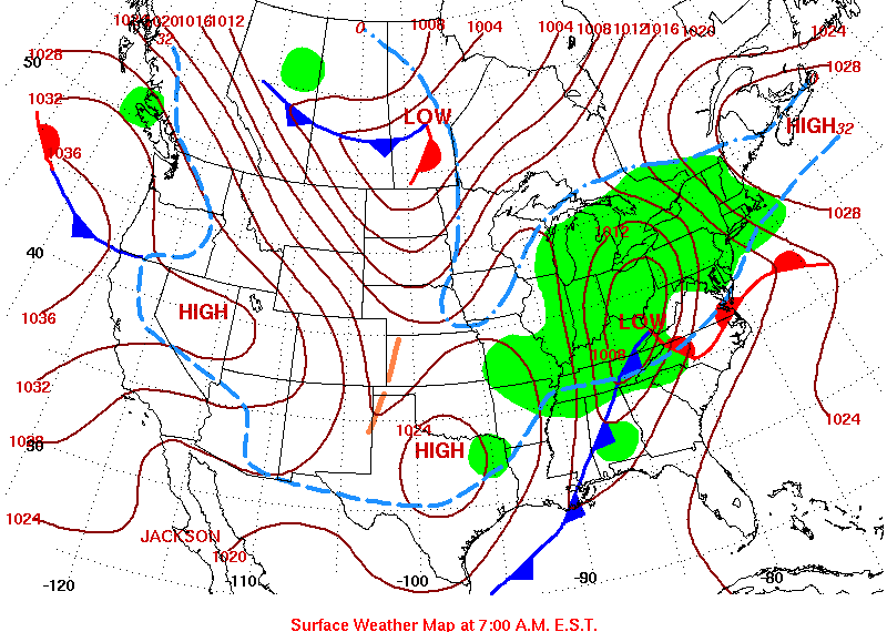 Surface Map from the morning of 28 of January |
Storm Reports
PUBLIC INFORMATION STATEMENT
SPOTTER REPORTS
NATIONAL WEATHER SERVICE STATE COLLEGE PA
155 PM EST THU JAN 29 2009

THE FOLLOWING ARE UNOFFICIAL STORM TOTAL SNOWFALL ACCUMULATIONS FROM
THE NATIONAL WEATHER SERVICE. THANKS TO PUBLIC AND COOP SPOTTERS FOR
YOUR REPORTS. THIS SUMMARY CAN ALSO BE FOUND ON OUR HOME PAGE AT
HTTP://WWW.NWS.NOAA.GOV/CTP

******************** STORM TOTAL SNOWFALL ************************

LOCATION          STORM TOTAL    TIME/DATE     COMMENTS
                     SNOWFALL       OF
                     (INCHES)   MEASUREMENT


PENNSYLVANIA

...ADAMS COUNTY...
   BIGLERVILLE            3.4   700 AM  1/29   COOP

...BEDFORD COUNTY...
   WOLFSBURG              3.1   700 AM  1/29   COOP
   BUFFALO MILLS          2.7   700 AM  1/29   COOP

...BLAIR COUNTY...
   TYRONE                 3.2   700 AM  1/29   COOP
   ALTOONA                2.2   700 AM  1/29   COOP

...CAMERON COUNTY...
   3S EMPORIUM            7.5   900 PM  1/28   SPOTTER
   SINNEMAHONING          5.0   700 AM  1/29   COOP

...CENTRE COUNTY...
   STATE COLLEGE          3.5   400 PM  1/28   GLAZE OF ICE/NWS
   PLEASANT GAP           3.0   700 AM  1/29   NWS EMPLOYEE
   UNIVERSITY PARK        2.8   700 AM  1/29   PSU METEO DEPT.

...CLEARFIELD COUNTY...
   CLEARFIELD             8.0   445 PM  1/28   0.25 ICE/SPOTTER
   GRAMPIAN               7.5   700 AM  1/29   COOP
   PENFIELD               5.0   830 PM  1/28   SPOTTER

...CLINTON COUNTY...
   LOCK HAVEN             3.2   700 AM  1/29   COOP

...COLUMBIA COUNTY...
   BENTON                 5.1   700 AM  1/29   COCORAHS

...DAUPHIN COUNTY...
   HARRISBURG CITY        3.0   447 PM  1/28   SPOTTER
   HARRISBURG INTL ARPT   2.7   500 PM  1/28   0.25 ICE/MDT OBSVR

...ELK COUNTY...
   RIDGWAY                7.0   700 AM  1/29   COOP
   GLEN HAZEL             6.0   700 AM  1/29   COOP

...LYCOMING COUNTY...
   MONTOURSVILLE          3.7   500 PM  1/28   GLAZE OF ICE/COOP
   WILLIAMSPORT           3.6   700 AM  1/29   GLAZE OF ICE/COOP
   CLARKSTOWN             3.0   700 AM  1/29   0.25 ICE/SPOTTER


...MCKEAN COUNTY...
   KANE                  12.0   800 PM  1/29   SPOTTER
   KANE                  10.2   700 AM  1/29   COOP
   BRADFORD               9.9   800 AM  1/29   COCORAHS
   PORT ALLEGANY          6.7   700 AM  1/29   COOP

...POTTER COUNTY...
   COUDERSPORT            7.0   700 AM  1/29   COOP
   BROOKLAND              6.5   300 PM  1/29   SPOTTER
   OSWAYO                 5.0   700 AM  1/29   COOP

...SCHUYLKILL COUNTY...
   MAHANOY CITY           5.6   700 AM  1/29   COOP
   ORWIGSBURG             4.8   900 AM  1/29   COCORAHS
   PINE GROVE             4.0   700 AM  1/29   0.25 ICE/COOP

...SOMERSET COUNTY...
   SOMERSET               4.1   700 AM  1/29   COOP
   LAUGHLINTOWN           5.9   700 AM  1/29   COOP

...SULLIVAN COUNTY...
   LAPORTE                6.0   700 AM  1/29   COOP

...TIOGA COUNTY...
   WESTFIELD              4.5   700 AM  1/29   COCORAHS
   WELLSBORO              4.5   700 AM  1/29   COOP
   TIOGA                  4.0   700 AM  1/29   COOP

...WARREN COUNTY...
   GRAND VALLEY          16.0   649 PM  1/28   SPOTTER
   RUSSELL               14.0   805 PM  1/28   SPOTTER
   CHANDLERS VALLEY      11.8   700 AM  1/29   COOP
   TIDIOUTE              10.0   800 PM  1/29   SPOTTER
   WARREN                 9.5   700 AM  1/29   COOP

...YORK COUNTY...
   GOLDSBORO              5.0   800 AM  1/29   COCORAHS
   YORK HAVEN             4.0   700 AM  1/29   COOP
 |
Media use of NWS Web News Stories is encouraged! Please acknowledge the NWS as the source of any news information accessed from this site. |
|


 Send Us a Report