Overview
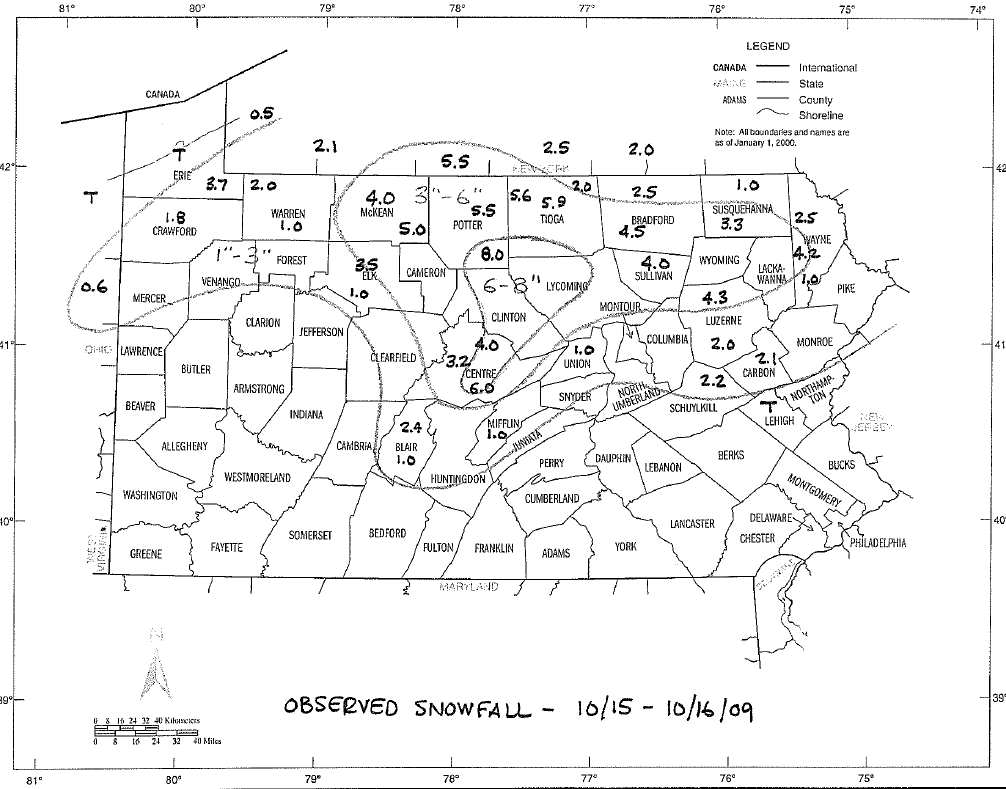
A very heavy and wet snow fell across Central Pennsylvania during the daytime on Thursday the 15th and all night into Friday the 16th of October, 2009.
This storm was noteworthy for two reasons:
1) This storm made the earliest measurable snow of any winter season on record in many places.
2) This storm produced a large amount of damage to trees (which also downed power and telephone lines) across much of the northern mountains and even down into State College.
An upper trough digging southward into the eastern U.S. from the Great Lakes helped to enhance a surface low forming over the Gulf Coast States - eventually spinning the storm up off the the North Carolina coast. The storm center then traveled toward Cape Cod and pulled a great amount of moisture into the mountains from the ocean.
Enough cold air was in place for the moisture to fall as snow over the central and northern mountains, but mainly rain in the southern third to half of the state.
 |
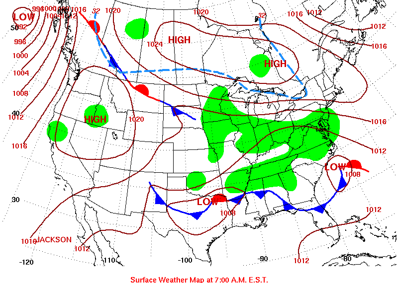 |
| Co-Operative Observer Snowfall from Thursday morning (15th) to Friday Morning (16th). | Surface Map from the morning of the 15th - with developing low off the Carolina Coast. |
Storm Reports
PUBLIC INFORMATION STATEMENT
SPOTTER REPORTS
NATIONAL WEATHER SERVICE STATE COLLEGE PA
1220 PM EDT FRI OCT 16 2009
THE FOLLOWING ARE UNOFFICIAL OBSERVATIONS TAKEN DURING THE PAST
24 HOURS FOR THE STORM THAT HAS BEEN AFFECTING OUR REGION.
THIS STORM OCCURRED VERY EARLY IN THE SEASON AND TREES STILL HAD
LEAVES. THE WET...HEAVY NATURE OF THE SNOW CAUSE WIDESPREAD TREE
DAMAGE OVER NORTH CENTRAL PENNSYLVANIA. WIDEPSREAD POWER OUTAGES
ALSO OCCURRED AS THE WEIGHT OF THE SNOW DROPPED POWER LINES.
APPRECIATION IS EXTENDED TO HIGHWAY DEPARTMENTS...COOPERATIVE
OBSERVERS...SKYWARN SPOTTERS AND MEDIA FOR THESE REPORTS.  THIS
SUMMARY IS ALSO AVAILABLE ON OUR HOME PAGE AT WEATHER.GOV/CTP
********************STORM TOTAL SNOWFALL********************
LOCATION          STORM TOTAL    TIME/DATE    COMMENTS
                     SNOWFALL       OF
                     (INCHES)   MEASUREMENT

PENNSYLVANIA
...BLAIR COUNTY...
   ALTOONA 1NE            2.4   700 AM 10/16   COOP
   TYRONE                 1.0   700 AM 10/16   COOP
   ALTOONA 1S             1.0   630 AM 10/16   NWS EMPLOYEE
...CENTRE COUNTY...
   CENTRE HALL 2W         9.0   700 AM 10/16   NITTANY MT. SUMMIT
   PORT MATILDA           6.0   700 AM 10/16   COCORAHS
   STORMSTOWN             6.0   600 AM 10/16   NWS EMPLOYEE
   PARK FOREST            6.0   700 AM 10/16   LARGE BRANCHES DOWN
   PLEASANT GAP           5.0   600 AM 10/16   NWS EMPLOYEE
   GRAYS WOODS            5.0   700 AM 10/16   COCORAHS
   BOALSBURG              4.9   600 AM 10/16   NWS EMPLOYEE
   STATE COLLEGE          4.7   630 AM 10/16   PENN STATE
   CLARENCE               4.0   700 AM 10/16   COOP
   PHILIPSBURG 2S         3.2   700 AM 10/16   COOP
...CLINTON COUNTY...
   HANEYVILLE             4.4  1030 PM 10/15   SPOTTER
...ELK COUNTY...
   ST. MARYS              3.5   700 AM 10/16   COCORAHS
   WILCOX                 2.5   700 AM 10/16   COOP
   RIDGWAY                1.0   700 AM 10/16   COOP
...MCKEAN COUNTY...
   KANE                   5.0   700 AM 10/16   COOP
...MIFFLIN COUNTY...
   LEWISTOWN              1.0   700 AM 10/16   COOP
...POTTER COUNTY...
   GERMANIA               8.0   700 AM 10/16   SPOTTER
   COUDERSPORT 7SE        5.5   700 AM 10/16   COOP
   ULYSSES                4.0  1015 PM 10/15   MANY TREE LIMBS DOWN
   GALETON                3.5   700 AM 10/16   COOP
...SCHUYLKILL COUNTY...
   MAHANOY CITY           2.2   700 AM 10/16   COOP
...SULLIVAN COUNTY..
   LAPORTE                4.0   700 AM 10/16   COOP
...TIOGA COUNTY...
   WELLSBORO              5.9   700 AM 10/16   COOP
   SABINSVILLE            5.6   700 AM 10/16   COOP
   COVINGTON              5.0   700 AM 10/16   COOP
   WESTFIELD 4S           4.5   700 AM 10/16   COCORAHS
   COWANESQUE DAM         2.0   700 AM 10/16   COOP
...UNION COUNTY...
   MIFFLINBURG            1.0   700 AM 10/16   NWS EMPLOYEE
...WARREN COUNTY...
   CHANDLERS VALLEY       2.0   700 AM 10/16   COOP
   WARREN                 1.0   700 AM 10/16   COOP
$$
TYBURSKI
 |
Media use of NWS Web News Stories is encouraged! Please acknowledge the NWS as the source of any news information accessed from this site. |
|


 Send Us a Report