Overview
On June 1st, 2012 a supercell produced two EF0 tornadoes that touched down in Alum Bank and North Hopewell Township, contributing to widespread damage across central Pennsylvania.
 |
 |
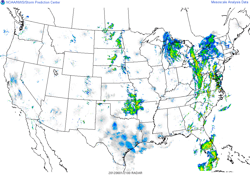 |
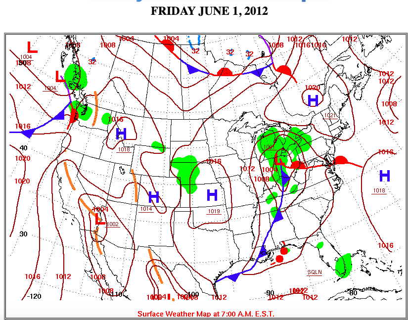
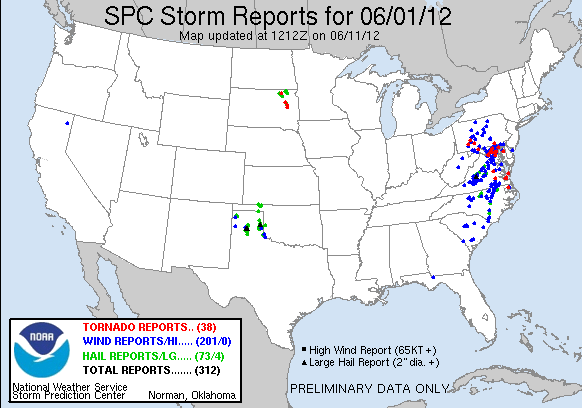
| WPC Surface Map 6/1/2012 | SPC Storm Reports for 06/01/12 | 21:00 UTC Radar |
Tornado Reports
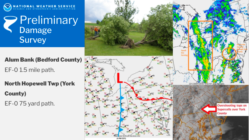
Tornado - Alum Bank
 |
|
512
NOUS41 KCTP 022039
PNSCTP
PAZ004>006-010>012-017>019-024>028-033>037-041-042-045-046-049>053-
056>059-063>066-030045-
PUBLIC INFORMATION STATEMENT
NATIONAL WEATHER SERVICE STATE COLLEGE PA
439 PM EDT SAT JUN 2 2012
...TORNADO CONFIRMED NEAR ALLUM BANK IN BEDFORD COUNTY
PENNSYLVANIA...
LOCATION...PLEASANTVILLE IN WEST ST. CLAIRE TOWNSHIP...BEDFORD
COUNTY PENNSYLVANIA
DATE...6/1/2012
ESTIMATED TOUCH DOWN TIME...618 PM EDT
MAXIMUM EF-SCALE RATING...EF0
ESTIMATED MAXIMUM WIND SPEED...70 MPH
MAXIMUM PATH WIDTH...75 YARDS
PATH LENGTH...1 1/2 MILES
BEGINNING LAT/LON...
ENDING LAT/LON...
FATALITIES...0
INJURIES...0
* THE INFORMATION IN THIS STATEMENT IS PRELIMINARY AND SUBJECT TO
CHANGE PENDING FINAL REVIEW OF THE EVENT(S) AND PUBLICATION IN NWS
STORM DATA.
...SUMMARY...
THE NATIONAL WEATHER SERVICE IN STATE COLLEGE PA HAS CONFIRMED A
TORNADO NEAR ALLUM BANK IN BEDFORD COUNTY PENNSYLVANIA ON 6/1/2012.
A THUNDERSTORM SPAWNED A SHORT LIVED WEAK TORNADO NEAR ALLUM BANK
IN BEDFORD COUNTY FRIDAY EVENING. THE TORNADO TOUCHED DOWN AT THE
INTERSECTION OF RTE 96 AND GORDON HALL ROAD AND WAS ON THE GROUND
FOR 1 1/2 MILES BEFORE LIFTING OFF AGAIN AT THE INTERSECTION OF
RTE 96 AND TOWNSHIP ROAD T606.
THE TORNADO WAS EMBEDDED WITHIN A LARGER AREA OF STRAIGHT LINE
WINDS. MAXIMUM WINDS WERE ESTIMATED AROUND 70 MPH WHICH DAMAGED A
BARN AND CAUSED MINOR DAMAGE TO 3 OTHER STRUCTURES. APPROXIMATELY
30 TREES WERE ALSO KNOCKED DOWN FROM THE STORM WHICH SEVERAL
WITNESSES REPORTED AS BEING ACCOMPANIED BY WHIRLING CLOUDS AND A
DRIVING RAIN.
THIS INFORMATION CAN ALSO BE FOUND ON OUR WEBSITE AT
WEATHER.GOV/CTP.
FOR REFERENCE...THE ENHANCED FUJITA SCALE CLASSIFIES TORNADOES INTO
THE FOLLOWING CATEGORIES:
EF0...WIND SPEEDS 65 TO 85 MPH.
EF1...WIND SPEEDS 86 TO 110 MPH.
EF2...WIND SPEEDS 111 TO 135 MPH.
EF3...WIND SPEEDS 136 TO 165 MPH.
EF4...WIND SPEEDS 166 TO 200 MPH.
EF5...WIND SPEEDS GREATER THAN 200 MPH.
$$
LA CORTE
Tornado - North Hopewell Township
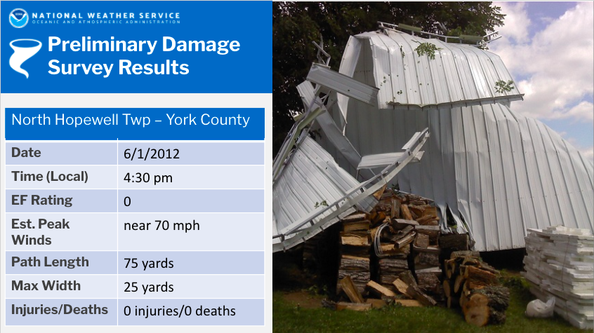 |
A SMALL TORNADO HAS BEEN CONFIRMED TO HAVE OCCURRED IN NORTH HOPEWELL TOWNSHIP IN
YORK COUNTY ON JUNE 1st.
LOCATION...NORTH HOPEWELL TOWNSHIP IN YORK COUNTY PENNSYLVANIA
DATE...JUNE 1 2012
ESTIMATED TIME...AROUND 430 PM EDT
MAXIMUM EF- SCALE RATING...EF0
ESTIMATED MAXIMUM WIND SPEED...NEAR 70 MPH
MAXIMUM PATH WIDTH...25 YARDS
PATH LENGTH...75 YARDS
BEGINNING LAT/LON... ENDING LAT/LON...
* FATALITIES...NONE
* INJURIES...NONE
* THE INFORMATION IN THIS STATEMENT IS PRELIMINARY AND SUBJECT TO
CHANGE PENDING FINAL REVIEW OF THE EVENT(S) AND PUBLICATION IN NWS
STORM DATA.
...SUMMARY...
A NATIONAL WEATHER SERVICE SURVEY TEAM INCLUDING THE YORK COUNTY
EMERGENCY MANAGEMENT AGENCY SURVEYED STORM DAMAGE WHICH OCCURRED
NEAR THE INTERSECTION OF LIST ROAD AND ROUTE 24 ABOUT 2 MILES
NORTH OF WINTERSTOWN IN NORTH HOPEWELL TOWNSHIP ON JUNE 1 2012.
A SMALL TORNADO HAD A BRIEF TOUCHDOWN IN THE AREA BLOWING A METAL
ROOF OFF A SINGLE LEVEL HOME AND SPLITTING A NEARBY TREE.
THE SEVERE THUNDERSTORM SPAWNING THE TORNADO MOVED NORTHEASTWARD
ACROSS SOUTHERN YORK COUNTY PRODUCING FUNNEL CLOUDS WHICH WERE
REPORTED AND CAPTURED WITH VISUAL IMAGERY FROM SHREWSBURY
TOWNSHIP INTO CHANCEFORD TOWNSHIP DURING THE LATE AFTERNOON OF
JUNE 1.
FOR REFERENCE...THE ENHANCED FUJITA SCALE CLASSIFIES TORNADOES INTO
THE FOLLOWING CATEGORIES:
EF0...WIND SPEEDS 65 TO 85 MPH.
EF1...WIND SPEEDS 86 TO 110 MPH.
EF2...WIND SPEEDS 111 TO 135 MPH.
EF3...WIND SPEEDS 136 TO 165 MPH.
EF4...WIND SPEEDS 166 TO 200 MPH.
EF5...WIND SPEEDS GREATER THAN 200 MPH.
Tornado Watch
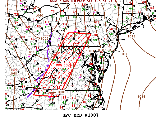
MESOSCALE DISCUSSION 1007
NWS STORM PREDICTION CENTER NORMAN OK
0235 PM CDT FRI JUN 01 2012
AREAS AFFECTED...SRN PA...WRN MD...ERN WV...WRN VA...NWRN NC
CONCERNING...TORNADO WATCH 332...
VALID 011935Z - 012030Z
THE SEVERE WEATHER THREAT FOR TORNADO WATCH 332 CONTINUES.
SUMMARY...COLD FRONT WILL SPREAD INTO THE WRN PORTIONS OF WW 332
SHORTLY WITH AN INCREASED RISK FOR SEVERE TSTMS. PRE-FRONTAL
ISOLATED SUPERCELLS SHOULD LINGER ALONG ERN EDGE OF WW 332.
DISCUSSION...FRONTAL CONVECTION IS PROGRESSING EWD AT ROUGHLY
25-30KT AND IS CRESTING THE APPALACHIANS AS IT MOVES INTO THE WRN
PARTS OF WW 332. THIS ACTIVITY WILL LIKELY INCREASE IN INTENSITY AS
IT APPROACHES CNTRL PORTIONS OF THE WATCH DUE TO MORE FAVORABLE
THERMODYNAMIC ENVIRONMENT CHARACTERIZED BY 1500-2000 J/KG MUCAPE.
GIVEN THE CURRENT SPEED OF THE COLD FRONT IT SHOULD APPROACH THE
ERN-MOST PART OF THE WATCH AROUND 23-00Z TIME FRAME. TORNADO THREAT
REMAINS HIGHEST WITH PRE-FRONTAL SUPERCELLS.
..DARROW.. 06/01/2012
ATTN...WFO...CTP...LWX...RAH...RNK...PBZ...RLX...GSP...
LAT...LON 36088173 40687891 40697662 36087955 36088173
Public Information Statement
512
NOUS41 KCTP 022039
PNSCTP
PAZ004>006-010>012-017>019-024>028-033>037-041-042-045-046-049>053-
056>059-063>066-030045-
PUBLIC INFORMATION STATEMENT
NATIONAL WEATHER SERVICE STATE COLLEGE PA
439 PM EDT SAT JUN 2 2012
...TORNADO CONFIRMED NEAR ALLUM BANK IN BEDFORD COUNTY
PENNSYLVANIA...
LOCATION...PLEASANTVILLE IN WEST ST. CLAIRE TOWNSHIP...BEDFORD
COUNTY PENNSYLVANIA
DATE...6/1/2012
ESTIMATED TOUCH DOWN TIME...618 PM EDT
MAXIMUM EF-SCALE RATING...EF0
ESTIMATED MAXIMUM WIND SPEED...70 MPH
MAXIMUM PATH WIDTH...75 YARDS
PATH LENGTH...1 1/2 MILES
BEGINNING LAT/LON...
ENDING LAT/LON...
FATALITIES...0
INJURIES...0
* THE INFORMATION IN THIS STATEMENT IS PRELIMINARY AND SUBJECT TO
CHANGE PENDING FINAL REVIEW OF THE EVENT(S) AND PUBLICATION IN NWS
STORM DATA.
...SUMMARY...
THE NATIONAL WEATHER SERVICE IN STATE COLLEGE PA HAS CONFIRMED A
TORNADO NEAR ALLUM BANK IN BEDFORD COUNTY PENNSYLVANIA ON 6/1/2012.
A THUNDERSTORM SPAWNED A SHORT LIVED WEAK TORNADO NEAR ALLUM BANK
IN BEDFORD COUNTY FRIDAY EVENING. THE TORNADO TOUCHED DOWN AT THE
INTERSECTION OF RTE 96 AND GORDON HALL ROAD AND WAS ON THE GROUND
FOR 1 1/2 MILES BEFORE LIFTING OFF AGAIN AT THE INTERSECTION OF
RTE 96 AND TOWNSHIP ROAD T606.
THE TORNADO WAS EMBEDDED WITHIN A LARGER AREA OF STRAIGHT LINE
WINDS. MAXIMUM WINDS WERE ESTIMATED AROUND 70 MPH WHICH DAMAGED A
BARN AND CAUSED MINOR DAMAGE TO 3 OTHER STRUCTURES. APPROXIMATELY
30 TREES WERE ALSO KNOCKED DOWN FROM THE STORM WHICH SEVERAL
WITNESSES REPORTED AS BEING ACCOMPANIED BY WHIRLING CLOUDS AND A
DRIVING RAIN.
THIS INFORMATION CAN ALSO BE FOUND ON OUR WEBSITE AT
WEATHER.GOV/CTP.
FOR REFERENCE...THE ENHANCED FUJITA SCALE CLASSIFIES TORNADOES INTO
THE FOLLOWING CATEGORIES:
EF0...WIND SPEEDS 65 TO 85 MPH.
EF1...WIND SPEEDS 86 TO 110 MPH.
EF2...WIND SPEEDS 111 TO 135 MPH.
EF3...WIND SPEEDS 136 TO 165 MPH.
EF4...WIND SPEEDS 166 TO 200 MPH.
EF5...WIND SPEEDS GREATER THAN 200 MPH.
$$
LA CORTE
 |
Media use of NWS Web News Stories is encouraged! Please acknowledge the NWS as the source of any news information accessed from this site. |
|


 Send Us a Report