|
Multiple tornadoes touched down across central pennsylvania during the afternoon hours of May 29, 2019. |
 |
|
Below you can find more information from each damage survey conducted in central PA: |
|
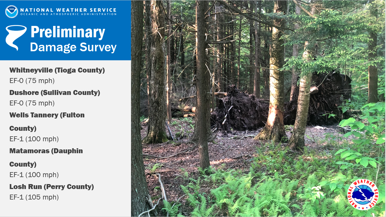
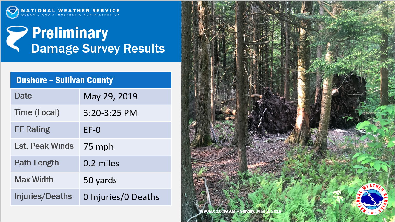
Dushore EF-0 Tornado (Sullivan County)
Whitneyville EF-0 Tornado (Tioga County)
Wells Tannery EF-1 Tornado (Fulton County)
Matamoras EF-1 Tornado (Dauphin County)
Losh Run EF-1 Tornado (Perry County)
Public Information Statement
National Weather Service State College PA
1129 AM EDT Sat Jun 1 2019

...EF-0 TORNADO CONFIRMED IN SULLIVAN COUNTY...

Location...Dushore in Sullivan County Pennsylvania
Date...May 29, 2019
Estimated Time...3:20 - 3:25 PM EDT
Maximum EF-Scale Rating...EF-0
Estimated Maximum Wind Speed...75 mph
Maximum Path Width...50 yards
Path Length...0.2 miles
* Fatalities...0
* Injuries...0

* The information in this statement is preliminary and subject to
change pending final review of the event(s) and publication in
NWS Storm Data.

...Summary...
The National Weather Service in State College PA has confirmed a
tornado near Dushore in Sullivan County Pennsylvania on May 29,
2019.

A survey team investigated damage on Friday May 31st associated
with a strong thunderstorm that moved through an area just east
of Dushore on Wednesday May 29th. Significant tree damage was
observed south of Route 87 and Dutch Mountain Road and north of
the Little Loyalsock Creek.

Additional details from the survey may be updated in the next
couple days.

This information can also be found on our website at
weather.gov/StateCollege.

For reference: the Enhanced Fujita Scale classifies tornadoes
into the following categories:

EF0...Wind speeds 65 to 85 mph
EF1...Wind speeds 86 to 110 mph
EF2...Wind speeds 111 to 135 mph
EF3...Wind speeds 136 to 165 mph
EF4...Wind speeds 166 to 200 mph
EF5...Wind speeds greater than 200 mph

&&

$$

Watson/Banghoff/Travis
Public Information Statement National Weather Service State College PA 1100 AM EDT Sun Jun 2 2019 ...EF-0 TORNADO CONFIRMED IN TIOGA COUNTY... Location...Whitneyville in Tioga County Pennsylvania Date...May 29, 2019 Estimated Time...2:10 PM EDT Maximum EF-Scale Rating...EF-0 Estimated Maximum Wind Speed...75 MPH Maximum Path Width...50 yards Path Length...1 mile * Fatalities...0 * Injuries...0 * The information in this statement is preliminary and subject to change pending final review of the event(s) and publication in NWS Storm Data. ...Summary... The National Weather Service in State College PA has confirmed a tornado near Whitneyville in Tioga County Pennsylvania on May 29, 2019. A survey team investigated damage on Friday May 31st associated with a strong thunderstorm that moved through an area just east southeast of Whitneyville on Wednesday May 29th. Significant damage to trees, a barn, and a trampoline was observed. The start point of the tornado path is 41.77014, -77.185232 and the end point was located at 41.770429, -77.16488. This information can also be found on our website at weather.gov/StateCollege. For reference: the Enhanced Fujita Scale classifies tornadoes into the following categories: EF0...Wind speeds 65 to 85 mph EF1...Wind speeds 86 to 110 mph EF2...Wind speeds 111 to 135 mph EF3...Wind speeds 136 to 165 mph EF4...Wind speeds 166 to 200 mph EF5...Wind speeds greater than 200 mph $$ Watson/Ceru/Tyburski Public Information Statement National Weather Service State College PA 643 PM EDT Fri May 31 2019 ...EF1 TORNADO CONFIRMED IN FULTON COUNTY... Location...Wells Tannery in Fulton County Pennsylvania Date...5/29/2019 Estimated Time...410 PM - 412 PM Maximum EF-Scale Rating...EF1 Estimated Maximum Wind Speed...100 mph Maximum Path Width...50 yards Path Length...3/4 miles * Fatalities...0 * Injuries...0 * The information in this statement is preliminary and subject to change pending final review of the event(s) and publication in NWS Storm Data. ...Summary... The National Weather Service in State College PA has confirmed a tornado near Wells Tannery in Fulton County Pennsylvania on 5/29/2019. The tornado touched down just west of 1159 Metzler Rd, Wells Tannery in Fulton County PA. It traveled east for about 3/4 miles knocking down dozens of trees. There was damage at 1695 Metzler Rd. where the roof was torn off a barn and the roof of a home was damaged. The storm lifted shortly after. This information can also be found on our website at weather.gov/StateCollege. For reference: the Enhanced Fujita Scale classifies tornadoes into the following categories: EF0...Wind speeds 65 to 85 mph EF1...Wind speeds 86 to 110 mph EF2...Wind speeds 111 to 135 mph EF3...Wind speeds 136 to 165 mph EF4...Wind speeds 166 to 200 mph EF5...Wind speeds greater than 200 mph $$ La Corte/Jung/Banghoff Public Information Statement...Corrected for path width National Weather Service State College PA 845 PM EDT Thu May 30 2019 ...EF-1 TORNADO CONFIRMED IN DAUPHIN COUNTY... Location...Matamoras in Dauphin County Pennsylvania Date...May 29, 2019 Estimated Time...424 PM to 428 PM EDT Maximum EF-Scale Rating...EF-1 Estimated Maximum Wind Speed...100 mph Maximum Path Width...100 yards Path Length...2.5 miles * Fatalities...0 * Injuries...0 * The information in this statement is preliminary and subject to change pending final review of the event(s) and publication in NWS Storm Data ...Summary... The National Weather Service in State College PA has confirmed a tornado near Matamoras in Dauphin County Pennsylvania on May 29, 2019. The tornado touched down near Route 225 north of Matamoras Rd. The tornado produced intermittent tree damage along a 2.5 mile path as it traveled to the east-southeast into Camp Hebron. The tree damage, which consisted of many uprooted trees and a few snapped tree trunks, was most intense near the end of the tornado's path in Camp Hebron. A separate area of tree damage near Halifax was determined to be the result of straight-line winds. This information can also be found on our website at weather.gov/StateCollege. For reference: the Enhanced Fujita Scale classifies tornadoes into the following categories: EF0...Wind speeds 65 to 85 mph EF1...Wind speeds 86 to 110 mph EF2...Wind speeds 111 to 135 mph EF3...Wind speeds 136 to 165 mph EF4...Wind speeds 166 to 200 mph EF5...Wind speeds greater than 200 mph $$ PJ/RR/MC Public Information Statement...corrected for event time National Weather Service State College PA 359 PM EDT Thu May 30 2019 ...EF1 TORNADO CONFIRMED IN PERRY COUNTY... Location...Losh Run in Perry County Pennsylvania Date...May 29, 2019 Estimated Time...414 to 419 PM EDT Maximum EF-Scale Rating...EF1 Estimated Maximum Wind Speed...105 mph Maximum Path Width...300 yards Path Length...approximately 4.8 miles * Fatalities...0 * Injuries...0 * The information in this statement is preliminary and subject to change pending final review of the event(s) and publication in NWS Storm Data. ...Summary... The National Weather Service in State College PA has confirmed a tornado near Losh Run in Perry County Pennsylvania on May 29, 2019. An EF1 tornado touched down southeast of Newport near the intersection of Route 849 and Narrows Road and progressed nearly due east for approximately 4.8 miles, finally lifting just east of the Juniata River near Route 322. The tornado downed hundreds of trees, including one tree that fell on a pickup truck. Some tree limbs fell onto rooftops, but little other property damage was observed. This information can also be found on our website at weather.gov/StateCollege. For reference: the Enhanced Fujita Scale classifies tornadoes into the following categories: EF0...Wind speeds 65 to 85 mph EF1...Wind speeds 86 to 110 mph EF2...Wind speeds 111 to 135 mph EF3...Wind speeds 136 to 165 mph EF4...Wind speeds 166 to 200 mph EF5...Wind speeds greater than 200 mph $$ PJ/RR/CE |


 Send Us a Report