Freezing Rain event New Years Day 2021
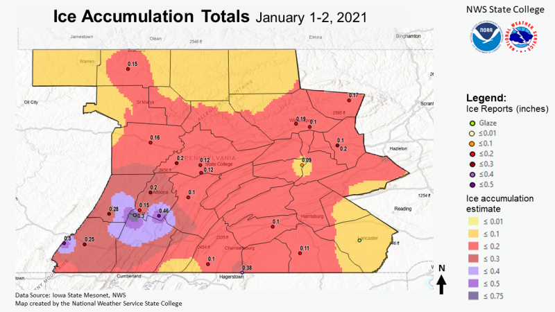
PNS Data:

000
NOUS41 KCTP 020949
PNSCTP
PAZ004>006-010>012-017>019-024>028-033>037-041-042-045-046-049>053-056>059-
063>066-022149-

PUBLIC INFORMATION STATEMENT
NATIONAL WEATHER SERVICE STATE COLLEGE PA
449 AM EST SAT JAN 2 2021

...FREEZING RAIN REPORTS...

LOCATION                     AMOUNT    TIME/DATE       PROVIDER

...PENNSYLVANIA...

...BEDFORD COUNTY...
3 WSW SKI GAP                0.66 IN   0934 PM 01/01   PUBLIC

...BLAIR COUNTY...
1 SSE MARTINSBURG            0.46 IN   0700 PM 01/01   ASOS
2 N ALTOONA                  0.20 IN   0854 PM 01/01   TRAINED SPOTTER
3 N SKI GAP                  0.15 IN   0744 PM 01/01   TRAINED SPOTTER

...CAMBRIA COUNTY...
2 NE GEISTOWN                0.28 IN   0700 PM 01/01   ASOS

...CENTRE COUNTY...
5 NE SANDY RIDGE             0.20 IN   0443 PM 01/01   EMERGENCY MNGR
1 WSW PINE GROVE MILLS       0.12 IN   1157 PM 01/01   PUBLIC

...CLEARFIELD COUNTY...
2 NE CLEARFIELD              0.16 IN   0700 PM 01/01   ASOS

...COLUMBIA COUNTY...
3 WNW BLOOMSBURG             0.20 IN   0930 PM 01/01   PUBLIC

...FRANKLIN COUNTY...
4 ESE MERCERSBURG            0.10 IN   0705 PM 01/01   TRAINED SPOTTER

...HUNTINGDON COUNTY...
HUNTINGDON                   0.10 IN   0400 PM 01/01   PUBLIC

...LYCOMING COUNTY...
MUNCY                        0.10 IN   1000 PM 01/01   PUBLIC

...MCKEAN COUNTY...
3 WSW CYCLONE                0.15 IN   0700 PM 01/01   ASOS

...SNYDER COUNTY...
1 NNE SELINSGROVE            0.09 IN   0700 PM 01/01   ASOS

...SOMERSET COUNTY...
SEVEN SPRINGS                0.50 IN   0250 PM 01/01   PUBLIC
SOMERSET                     0.25 IN   0320 PM 01/01   TRAINED SPOTTER

...SULLIVAN COUNTY...
3 SSE DUSHORE                0.17 IN   1100 PM 01/01   TRAINED SPOTTER

...YORK COUNTY...
THOMASVILLE                  0.11 IN   0700 PM 01/01   ASOS
&&

OBSERVATIONS ARE COLLECTED FROM A VARIETY OF SOURCES WITH VARYING
EQUIPMENT AND EXPOSURES. WE THANK ALL VOLUNTEER WEATHER OBSERVERS
FOR THEIR DEDICATION. NOT ALL DATA LISTED ARE CONSIDERED OFFICIAL.

$$


 Send Us a Report