Historical Rainfall Event for the Cape Fear Region
Overview | Surface Analysis | Water Vapor Imagery | Radar Imagery | Rainfall Totals Map | Event Summaries
MONDAY | TUESDAY | WEDNESDAY | THURSDAY
|
Monday, September 27th Showers began to overspread the area early Sunday afternoon ahead of the initial frontal boundary. However, most of this activity occurred across inland portions of the Weather Forecast Office (WFO) Wilmington County Warning Area (CWA). By late Monday morning, convection had become widespread across most of northeastern South Carolina and southeastern North Carolina.This enhanced convection was associated primiarly with increasing upper level diffluence associated with the southeastward progression of the upper low over the TN/AL area. |
|
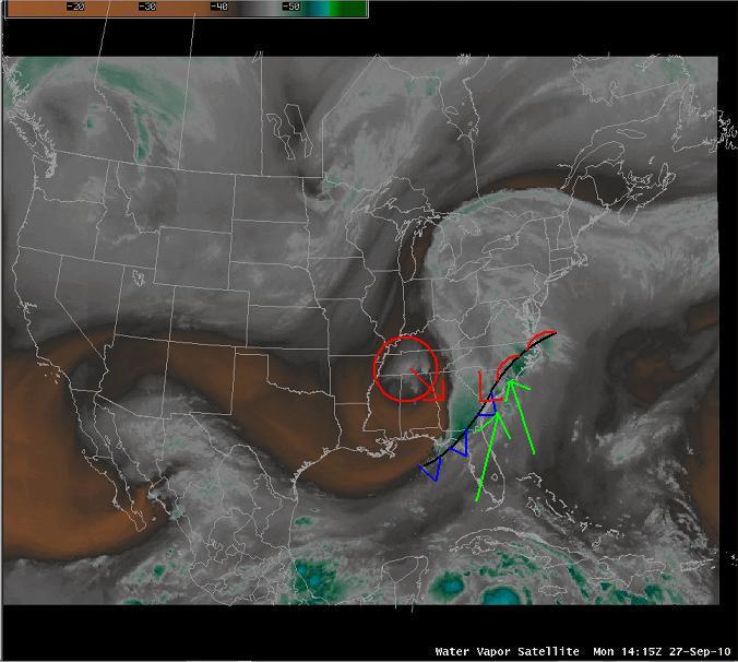 Water Vapor Imagery at 14z Monday Water Vapor Imagery at 14z Monday |
|
| Although the rainfall tapered off across the Pee Dee and inland NC areas during the afternoon, the area of low pressure over Georgia continued to move northeast. A leading warm front was draped along the coast as well which allowed for significant overrunning of tropical moisture. This feature, combined with increasing upper diffluence as the trough became more negatively tilted, began to focus incredibly heavy rainfall along the Cape Fear coast. This prompted NESDIS to issue a SPENES Message outlining the continued heavy rain threat. | |
 Surface Analysis at 15z Monday |
|
| Persistent rainfall rates of 1/2" per hour or more fell at the Wilmington, NC airport through the day...with a peak of 1.99" in one hour. It was during this time that WFO ILM issued their first Flash Flood Warning (FFW) for Brunswick, New Hanover, and Pender Counties, letting people know of the seriousness of this situation. It was the first of 16 FFW's that would be issued during the upcoming days.
As the low pressure moved slowly NE, west of the Cape Fear Coast, the heavy rain finally began to abate with the northward progress of the warm front and subsequent offshore movement of the stationary boundary. However, by the end of the day record daily rainfall had occurred at Wilmington, and the WFO issued this impressive Record Event Report. The tremendous rainfall across the Cape Fear Region caused minor flooding on Monday...but with another 6 to 10" of rainfall forecast for the rest of the week, flooding became a serious concern for the ILM CWA. |


 Coastal Flood