 Hurricane Fran developed from a tropical wave that moved off the coast of Africa on August 22, 1996. After becoming a tropical depression on August 23rd, Fran strengthened into a powerful category three hurricane with maximum sustained winds of 120 mph while north of the Bahamas on September 4th. Weakening slightly as it approached the North Carolina coast, Fran made landfall near the tip of Cape Fear with maximum sustained winds near 115 mph on the evening of September 5th. Fran was responsible for 26 deaths and was at the time the most expensive natural disaster ever in North Carolina's history.
Fran was the second of four strong hurricanes to directly strike Southeastern North Carolina during the mid to late 1990s. (Hurricane Bertha hit in July 1996, Hurricane Bonnie in August 1998, and Hurricane Floyd in September 1999) Fran struck southeastern North Carolina before damage from Hurricane Bertha was fully cleaned up and repaired. In the same way that residents of Columbia and Charlotte remember Hurricane Hugo's devastating inland winds, residents of Raleigh and most of the North Carolina inland coastal plain think back to Fran when discussing the strong wind a hurricane can bring well away from the coast.
Meteorological History
|
GOES-8 visible satellite loop of Hurricane Fran. September 5, 1996 |
GOES-8 infrared satellite loop of Hurricane Fran. September 5, 1996 |
The National Hurricane Center issued a Hurricane Watch for the South Carolina coast at 11 p.m. on September 3rd, and extended it to include coastal North Carolina the following morning. Hurricane Warnings were issued at 5 p.m. on September 4th. Evacuations for the beach towns of New Hanover and Brunswick Counties were ordered to be complete by noon on Wednesday September 5th. Classes were cancelled at UNC-Wilmington and the 1,900 on-campus students were asked to leave for the duration of the storm. All local schools including Cape Fear Community College were closed and all city/county offices in the Cape Fear region closed early.
Forecasts for Fran initially called for a South Carolina landfall as a category 3-4 storm. This implied a landfall perilously close to high tide on Wednesday, an event that would have produced an unspeakable amount of damage. Comparisons to Hurricane Hazel were discussed in the local media. Fortunately for South Carolina, Fran's path curved to the right sparing the state a direct impact. Fran also weakened slightly as it approached the coast with maximum sustained winds dropping to around 115 mph -- still a very strong category three hurricane on the Saffir-Simpson Hurricane Wind Scale.
|
Radar loop of the Hurricane Fran's landfall, 7:17 pm until 9:03 pm on September 5, 1996. A zoomed-out 12-hour loop is available here. |
Landfall occurred around 8:30 pm on Thursday September 5, 1996 as the ragged eye crossed over Bald Head Island and Southport, NC. A barometer on the NOAA ship Whiting, docked in the Cape Fear River near Wilmington, read 959.9 millibars or 28.35 inches. Wind gusts of 105 mph were recorded at the State River Pilot office in Southport. Offshore at the Frying Pan Shoals tower gusts to 124 mph were measured at about 80 feet elevation. At the Wilmington airport winds reached 86 mph in gusts. Unofficial wind gusts were measured by rooftop weather equipment as high as 125 mph at Wrightsville Beach and 137 mph along Hewitt's Creek in Wilmington. Later investigation revealed these two anemometers were mounted very close to rooflines and the readings were likely too high.
Even though Fran made landfall near the time of low tide a large storm surge pushed across the beaches causing tremendous destruction. Total storm tide reached as high as 12 feet north of Cape Fear from Carolina Beach across Wrightsville Beach to Topsail Island. This water level in combination with crashing waves was sufficient to destroy beachfront dunes and overwash many locations along the barrier islands of Southeastern North Carolina. A fascinating graphic produced by the USGS shows the amount of overwash that occurred during Fran compared to Hurricane Bertha earlier in the summer.
After landfall Fran moved into interior eastern North Carolina; the storm's center took a path across Boiling Spring Lakes and the towns of Delco, White Lake, Roseboro, Dunn and Buies Creek. Although weakening, Fran still brought hurricane-force wind gusts and tremendous damage to trees and power lines across a broad swath of eastern North Carolina. Wind gusts were measured at 100 mph in Greenville, 81 mph in Goldsboro, and 79 mph in both Fayetteville and Raleigh. Author Jay Barnes in North Carolina's Hurricane History also reports wind gusts of 122 mph on Figure Eight Island and 105 mph in New Bern. (These were not part of the official National Hurricane Center report) Fran's eye disintegrated before it reached Interstate 85 and the system was downgraded to a tropical storm as it moved near Durham. Fran entered Virginia between Danville and Halifax just before sunrise on Thursday September 6th. Even after moving across 200 miles of land Fran still brought wind gusts of 50 to 65 mph across much of southern Virginia from Roanoke in the mountains to Norfolk on the coast.
Surface Weather Analysis Maps
 |
These maps were hand-analyzed in August 2015 using historic airport and buoy observations taken at six-hour intervals during Hurricane Fran.
Guide to decoding a station model |
|
The NOAA/AOML Hurricane Research Division created these high-resolution (H*wind) analyses using data collected by aircraft and a variety of surface observations. Wind speeds are given in knots and are valid at 10 meters above ground level in regions of open marine exposure. |
|
Public Impact
Fran was the worst storm to strike southeastern North Carolina since Hurricane Hazel in 1954. According to the Wilmington Star-News, Fran knocked out electricity for 1.5 million people. Of the 26,000 customers served by Four County Electric Co-op only 100 still had working electrical service after the storm. Interstate 40, U.S. highways 17 and 74/76, and College Road near Castle Hayne were closed for a time due to trees blown across the roadway. Hurricane Fran was responsible for 26 deaths and $4.16 billion in damage according to a report from the National Hurricane Center.
In Wilmington, 75 percent of homes sustained some damage, with 24 percent sustaining major damage. Historic First Baptist Church downtown lost its 197-foot steeple which landed in Market Street. Galloway Hall at UNC-Wilmington lost a portion of its roof and suffered significant water damage. Curfews were in place for Wilmington and New Hanover County from 10 p.m. until 6 a.m. for several days after the storm. Wrightsville Beach, Kure Beach and Carolina Beach were completely closed to all but emergency workers.
| Hurricane Fran in Carolina Beach from Jim Leonard |
Storm surge flooding in Carolina Beach reached six feet across Lake Park Blvd, flooding many businesses and the town fire station. Three feet of sand was left behind on parts of Carolina Beach Ave. The Carolina Beach Fishing Pier, heavily damaged during Hurricane Bertha earlier in the summer, was completely destroyed along with the restaurant. The Star-News interviewed Carolina Beach resident Granger Soward who stayed at his home through the storm; during the eye he watched a manatee swim up to his back door! At Kure Beach part of Atlantic Avenue was undermined by the storm surge and impassible after the storm. The portion of Kure Beach Pier that survived Bertha was destroyed. At least 200 homes were damaged with about 25 beachfront homes destroyed in the south part of town along Fort Fisher Blvd.
At Wrightsville Beach, Fran destroyed part of Crystal Pier and most of Johnnie Mercer's Pier. Most of the island's dunes were flattened and sand covered most residential roads near the beach. Figure Eight Island's main road was covered in three feet of sand, and some homes had enough sand scoured from their yards to expose parts of septic systems. Many beachfront homes had their first floors knocked out by Fran's storm surge.
Topsail Island was almost completely overwashed by the storm tide which reached 12 feet in places. The Surf City fire station was destroyed, as was the North Topsail police station. The Surf City Pier, Scotch Bonnet Pier, Ocean City Pier, and Barnacle Bill's Pier were heavily damaged. North Topsail Beach lost an entire row of beachfront homes and a 60-foot section of highway 210. Topsail Island was breached in six places according to the Star-News, with 331 homes destroyed.
In Duplin County the dome of the historic courthouse in Kenansville was blown down. The Raleigh News & Observer stated that nearly every road across Duplin and Sampson Counties was impassible due to trees felled by high winds. The city of Raleigh experienced significant wind damage and flooding. Thousands of tall oaks crashed to the ground during the hurricane-force gusts, with power lines and houses subsequently damaged. Crabtree Creek, normally a small stream almost unnoticed in the midst of a major commercial district, filled with Fran's rainfall and rose seven feet above flood stage. This flooded Crabtree Valley Mall as well as nearby neighborhoods.
Farther up the coast Fran's surge was generally lower with five feet measured in Beaufort, NC, and seven feet at Atlantic Beach, NC. However the surge was funneled into river estuaries with observations of up to a 10 foot surge in New Bern, and nine feet in the towns of Belhaven and Washington. This surge was sufficient to flood the majority of downtown Washington. A portion of the roadway leading up to the Highway 17 bridge in downtown New Bern was washed out.
The Cape Fear River crested about seven feet above flood stage at Lock and Dam #2 in Elizabethtown, but at Lock and Dam #3 near the Cumberland County line the river reached 17 feet above flood stage. The Northeast Cape Fear River in Pender and Duplin Counties had significant flooding. Homes along highway 53 near Burgaw and Holly Shelter Creek had up to ten feet of water inside. This was several years before the Burgaw river gauge was installed along this portion of the river.
In Columbus County about two-thirds of the county residents lost power due to downed trees. County officials said 92 homes suffered major damage, 128 homes had minor damage, and one mobile home was destroyed. Duplin County suffered over $30 million in agricultural losses with complete losses to the county's tobacco crop. Reports state 300,000 turkeys and chickens were killed. Residents of the Crusoe Island community were isolated due to flooding along the Waccamaw River. At one point Lake Waccamaw was reportedly 26 inches above the dam spillway. In Brunswick County cotton, tobacco and corn crops were heavily damaged by Fran and by Bertha earlier in the summer. Storm surge and beach erosion claimed a small number of beach houses on Ocean Isle Beach and Holden Beach. Overall damage to structures was mild considering the situation.
|
Photo from NC Division of Marine Fisheries. North Topsail Beach, NC |
Photo from NC Division of Marine Fisheries. North Topsail Beach, NC |
|
Photo from NC Division of Marine Fisheries. North Topsail Beach, NC |
Photo from NC Division of Marine Fisheries. North Topsail Beach, NC |
|
Photo from NC Division of Marine Fisheries. North Topsail Beach, NC |
Photo from NC Division of Marine Fisheries. North Topsail Beach, NC |
Lowest Pressures, Highest Wind Gusts, Storm Surge/Tide, and Rainfall Totals from Hurricane Fran
| Location | Lowest Pressure | Highest Gust | Storm Surge | Storm Tide | Rainfall |
| South Carolina | |||||
| Cherry Grove Pier | 77 mph | 8.36" | |||
| Myrtle Beach Pavilion | 76 mph | ||||
| Myrtle Beach Pier | 75 mph | 3.6 feet | 7.02" | ||
| Garden City Pier | 74 mph | 5.91" | |||
| Florence | 64 mph | 2.21" | |||
| Cheraw | 992.2 mb, 29.30" | 64 mph | 1.32" | ||
| Conway | 55 mph | 5.02" | |||
| Loris | 54 mph | 5.14" | |||
| Folly Island | 997.6 mb, 29.46" | 47 mph | |||
| Charleston | 47 mph | 1.1 feet | 0.87" | ||
| Charleston Airport | 998 mb, 29.47" | 41 mph | 1.10" | ||
| Dillon | 4.62" | ||||
| Mullins | 3.98" | ||||
| Marion | 3.01" | ||||
| North Carolina | |||||
| Frying Pan Shoals Tower | 960.6 mb, 28.37" | 124 mph | |||
| Southport River Pilot | 105 mph | ||||
| Atlantic Beach | 100 mph | ||||
| Greenville | 100 mph | ||||
| New River | 982 mb, 29.00" | 94 mph | 7.05" | ||
| Beaufort | 92 mph | 5.4 feet | |||
| Wilmington Airport | 961.4, 28.39" | 86 mph | 5.09" | ||
| Cape Lookout | 996.9 mb, 29.44" | 82 mph | |||
| Goldsboro | 981 mb, 28.97" | 81 mph | 6.38" | ||
| Raleigh/Durham Airport | 977.6 mb, 28.87" | 79 mph | 8.80" | ||
| Fayetteville Airport | 971.6 mb, 28.69" | 79 mph | |||
| Cherry Point MCAS | 993.9 mb, 29.35" | 76 mph | |||
| Diamond Shoals Tower | 1006.6 mb, 29.72" | 75 mph | |||
| Fort Bragg | 972.3 mb, 28.71" | 74 mph | 4.70" | ||
| Holden Beach | 69 mph | ||||
| Pope Air Force Base | 977.6 mb, 28.87" | 67 mph | 6.72" | ||
| Elizabeth City Airport | 1005.1, 29.68" | 55 mph | |||
| Greensboro Airport | 984.4 mb, 29.07" | 48 mph | 3.91" | ||
| Rocky Mount Airport | 980.7 mb, 28.96" | 45 mph | 3.68" | ||
| Graham | 6.65" | ||||
| Butner | 6.21" | ||||
| Apex | 6.06" | ||||
| Newport | 3.24" | ||||
| Duck Pier | 1.5 feet | ||||
| Figure Eight Island | 10-12 feet | ||||
| Wrightsville Beach | 10-11 feet | ||||
| North Topsail Beach | 8-9 feet | ||||
| Wilmington Tide Gauge | 5.5 feet | ||||
| Oregon Inlet | 2.3 feet | ||||
| NOAA Ship Whiting | 959.9 mb, 28.35" | ||||
| Virginia | |||||
| Norfolk NAS | 1004.6 mb, 29.67" | 63 mph | 2.6 feet | ||
| Hot Springs Airport | 1002.4 mb, 29.59" | 55 mph | |||
| Danville Airport | 987.5 mb, 29.16" | 53 mph | |||
| Richmond Airport | 1000.8 mb, 29.66" | 53 mph | |||
| Roanoke Airport | 994.7 mb, 29.37" | 51 mph | |||
| Staunton Airport | 997.6 mb, 29.46" | 49 mph | |||
| Charlottesville Airport | 998.6 mb, 29.49" | 44 mph | |||
| Lynchburg Airport | 990.6 mb, 29.25" | 44 mph | |||
| Washington D.C. | 5.6 feet | ||||
In addition to the National Hurricane Center report on Fran, additional storm tide data was published in a March 1997 "Civil Engineering" journal article Fran-Spotting by Patricia W. McDermott and Darryl J. Hatheway. They list the following supplemental storm tide heights derived from precise measurement of high-water marks and debris lines with heights accurate to 2 inches using differential GPS.

| Caswell Beach to Southport | 5.4 to 11.2 feet NGVD |
| Kure Beach to Carolina Beach | 9.8 to 12.5 feet NGVD |
| Wrightsville Beach to Figure Eight Island | 9.3 to 12.7 feet NGVD |
| Howard Landing to Watts Landing | 9.6 to 12.6 feet NGVD |
| Topsail Beach to Surf City | 8.1 to 10.7 feet NGVD |
| Surf City to North Topsail Beach | 8.1 to 11.5 feet NGVD |
| Morris Landing to Thomas Landing | 8.8 to 9.4 feet NGVD |
| Hubert to Swansboro | 8.1 to 8.9 feet NGVD |
| Bogue Inlet to Morehead City | 4.8 to 7.3 feet NGVD |
| Fort Macon State Park to Beaufort | 4.5 to 5.9 feet NGVD |
Ecological Impact
 With the near-complete destruction of the protective beachfront dunes and severe overwashing/scouring of the barrier islands north of Cape Fear, Hurricane Fran re-wrote the face of Southeastern North Carolina. Tremendous volumes of debris from demolished houses and docks littered the beaches and nearshore ocean environment after the storm. Septic systems and municipal system overwhelmed by the amount of rain and saltwater leaked raw sewage into the ocean and marshes. Any sea turtle nests still waiting to hatch were undoubtedly destroyed along with the beaches themselves.
An artificial reef about five miles off Topsail Island was the final destination for thousands of used tires. This reef was constructed to enhance habitat for fish and local fishermen. Unfortunately Fran's waves and surge destroyed the reef and deposited many of the tires along the beach.
A report from North Carolina Department of Forestry estimated Fran damaged 8.2 million acres of forest, with losses estimated at over $1 billion. While much of this loss was due to strong winds blowing down trees, salt spray near the coast also damaged trees and made them vulnerable to later insect damage.
Landfalling hurricanes often cause disturbances to marine and coastal bird species. The report Storms of '96: Birds and Atlantic Tropical Cyclones in an Active Year referenced reports of Sandwich Terns, Royal Terns, Sooty Terns, and Bridled Terns at several of the large lakes near Raleigh including Jordan Lake, Falls Lake, and Harris Lake. As was seen during Hurricane Hugo, seabirds transported inland by the hurricane often "fall out" and congregate near inland lakes as winds diminish below hurricane force.
Local Stories from the Wilmington Morning Star newspaper (now called the Star-News)
|
|
|
|
|
|
|
|
|
|
|
|
|
|
|
|
|
|
|
|
|
Personal Stories
 Katherine Nunn: I saw the Milky Way in my own backyard for the 1st time in Sept 1996. The sky was so dark due to all the power outages. (shared from Twitter)
Darwin Brandis: I'll never forget hearing pine trees snap like toothpicks, and the scary wait to see if they'd fall on the house or not. (shared from Twitter)
James K. Lewis II: watched as about 50 trees and power poles fell ! was without power 5 days ! (shared from Facebook)
Tracy Kelly Eames: Yes! I remember it like it was yesterday! I have tons of video. It was BAD!! (shared from Facebook)
Mary Blades: Just wanted to share my story with you in regards to Fran. I lived in Fuquay-Varina at the time, and Fran was the first hurricane to maintain its strength and come all the way to the Raleigh area. Now, I've never been through a hurricane before, so even a Category 1 was enough to make me nervous.
I took my children and we all slept in a windowless room until about 3 in the morning. At that time I heard water coming into the daylight basement, in the room next to where we were sleeping. The rain had managed to come into the corner and was seeping over to us. I quickly woke the children and took them upstairs. The wind sounded like a wide open engine...it was so loud. Not sure why I felt the children were safer with me, but I wouldn't let them out of my sight.
Then the eye crossed over...it got so quiet, eery kind of stillness. The back side of Fran was not as bad, and as dawn began, I looked out my window to not too much damage. Of course, trees were down so we couldn't travel anywhere for a few days. And it took a really long time to get our power back on...at least a week. We had a grill, so we were cooking up everything from the freezer as fast as we could & feeding the neighbors. (shared via email)
Gewn Bowman Goins: I remember my oldest son had just turned one the day before (shared from Facebook)
Steve Austin: I lived 25 miles east of Raleigh when fran hit, it had been less than a year losing my wife to pancreasitis. Horrible storm. I won’t forget it. (shared via email)
George Hardy: Fran and Bertha-remember them both well (shared from Facebook)
Jessica Paramore: This is what started my fascination with weather. I spent my 16th birthday watching Fran come on shore. We lived in Grifton NC and while we were a ways away from the coast I will never forget those long hours of horrible wind and rain. It was like it would never stop. We only lost two pine trees and power for two days, but some of our neighbors had it much worse. (shared via email)
Ed & Michelle Hartle: Thank you for the chance to tell our Hurricane Fran story. We actually did consider hurricane season in the planning of our wedding. We chose to go to Hawaii for the honeymoon instead of the Caribbean - we had not heard of hurricanes hitting Hawaii at that time. We never dreamed our wedding could be affected so far inland as that occurrence is rather rare in the Carolinas.
My wife Michele and I were married in Chapel Hill, NC on Saturday, September 7, 1996, just after Hurricane Fran changed the landscape of Chapel Hill. We had big plans for Friday including golf for the groomsmen, a luncheon for the bridesmaids and a catered rehearsal dinner featuring delicious NC BBQ by Allen & Sons. Fran had other ideas. It came thundering through on Thursday night. One of the bridesmaids landed from Rhode Island on the last flight allowed to land at RDU on Thursday evening. FEMA and other government reps on the flight were asking why on earth she was flying into the path of a hurricane. No one else on the flight seemed to be traveling to Raleigh for pleasure or celebration. The ladies went to my wife’s home in Carrboro, an older home nestled among a small forest of huge old oak trees where they worked on wedding preparations while watching the news of Fran moving onshore. No one expected Fran to come so far inland. Suddenly, around 11:00 pm, while folding programs and catching up, the power went out and the winds began to howl. It continued to roar most of the night. Miraculously, even though the yard was littered with branches and debris, the house and car were spared from damage; the large limbs somehow missing the house and car. Some neighbors weren’t so fortunate.
I woke up Friday to a beautiful Carolina morning with an intact house, but no power. My response was to break out the Coleman stove and fire up pancakes, bacon and coffee for myself and my 3 children. The Finley golf course had become an obstacle course. The rehearsal dinner hosting site was a shambles, but that did not matter. The BBQ folks, who lived in the country, were trapped on their farm for 2 days by fallen trees until they could chainsaw their way out. Only places with emergency generators had power.
Our families started arriving. Michele's mom's family arrived Friday barely able to cross some roads before they were closed due to flooding and managed to crowd into the few reserved hotel rooms that still had power. My family came in from the North and did the same. My sister, a pastry chef, had baked our wedding cake had to dodge falling trees on the highway and through Chapel Hill. When she arrived late on Thursday evening in the dark and pouring rain, it was almost impossible to find someone to let her in at the Carolina Club on campus. Finally, she found a security officer to let her in to put the cake in the refrigerator. Fortunately, the facility had power – one of the few places in town to have power throughout the event. Miraculously, Michele's father arrived from Roanoke, Virginia and literally walked into his spot in the wedding rehearsal at St. Thomas More Catholic Church on Friday afternoon. Michele shed tears of joy – his presence was the last necessary item on the checklist. The rehearsal was a skeleton crew. The priest was phenomenal at passing out tissues and making everything flow flawlessly!
Other groomsmen were en route. I called and requested that they bring batteries and ice. All fell together in perfect harmonic convergence on Friday evening. Saturday, our wedding day, was a true example of a glorious early autumn day in North Carolina. The florist had to trudge through knee-deep water to pack and deliver the beautifully arranged flowers. Trees needed to be cut from the roads so the church could be accessed. The church had no power, but it did not matter the windows were open and warm breezes blew. We were having a candlelit wedding at noon – a nice touch but we didn’t want it at this price. The string quartet, Musica, which we had hired was utterly untroubled by the lack of power. Their instruments predated Franklin and Edison.
The only bump in the road was the need to bribe the guy running a chainsaw next door so he would work in the back of his house.
 |
 |
 |
The wedding was glorious with the power of God, joy and love. It is certainly unforgettable as are the many sacrifices of family and friends. The lack of electricity was just a humorous footnote to be recounted in stories like this one. The reception at the Carolina Club had every kind of power.
We danced, ate and drank and all had a marvelous time. Our wedding night was at the Fearrington Inn south of Chapel Hill which thank heavens had power.
We then flew to Hawaii for our honeymoon. The Sunday headlines read, “Now the Real Work Begins.” My wife married a widower with 3 kids – a lot of irony was packed into that headline. On the plane, the first song we heard was "Our Love Can Survive a Hurricane." We looked at each other and laughed – more irony. Neither of us had ever heard the song before or since. That was 19 years ago and we are still happily married. Our love did survive Hurricane Fran and the lesser storms of life which have occurred since. We were so blessed to have such an eventful wedding. (shared via email)
Local Videos
| Jim Mincher's remarkable video from Wrightsville Beach, NC during Hurricane Fran showing wind, flooding, and damage. | Jim Mincher's detailed video account of Fran's damage in Wrightsville Beach, NC |
| WPDE-TV 5 pm newscast September 5, 1996 | HurricaneTrack storm video from Leland, NC |
|
WWAY TV-3 Wilmington documentary Hurricane Alley '96 detailing the impacts of Hurricanes Bertha and Fran on the Cape Fear area. |
 Local Photos
Photos taken from the Blockade Runner resort at Wrightsville Beach
USGS photos from Topsail Beach and West Onslow Beach
Photos from Kure Beach and Durham, NC
Surf City Pier photos of hurricane damage, including Fran
Other Resources on Hurricane Fran
National Hurricane Center: Preliminary Report on Hurricane Fran
National Weather Service Newport/Morehead City, NC: Hurricane Fran Event Overview
National Weather Service Raleigh, NC: Hurricane Fran
National Weather Service: Hurricane Fran Service Assessment
NWS Weather Prediction Center: Rainfall Analysis
National Institutes of Standards & Technology: Hurricane Fran in North Carolina by Richard D. Marshall
FEMA: Building Performance Assessment: Hurricane Fran in North Carolina
USGS: Aftermath of Hurricane Fran in North Carolina, Preliminary Data on Flooding and Water Quality
East Carolina University/RENCI: Hurricane Fran
USAtoday: Flight into Fran was a Rare One for a Storm Over Land by Jack Williams
Intense Sub-Kilometer-Scale Boundary Layer Rolls Observed in Hurricane Fran by Wurman and Winslow
Page Author: Tim Armstrong
Page Created: September 2, 2015
Last Updated: September 5, 2015


 Coastal Flood
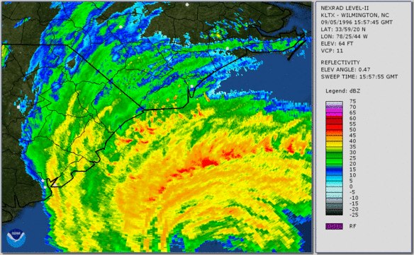