Drought
After a spring plagued by severe drought across the Carolinas, concerns about rainfall through the coming summer are foremost on our minds. Rain gauges at local airport climate stations have recorded below normal precipitation almost every month so far this year.
| January | February | March | April | May | YTD Total | Departure from Normal | |
| Wilmington, NC | 1.41" | 3.01" | 2.03" | 0.94" | 4.27" | 11.16" | -7.38" |
| Lumberton, NC | 1.69" | 2.48" | 1.00" | 1.30" | 4.82" | 11.29" | -3.71" |
| N. Myrtle Beach, SC | 1.42" | 2.41" | 0.78" | 0.51" | 1.21" | 6.77" | -8.87" |
| Florence, SC | 1.86" | 3.27" | 0.58" | 1.05" | 6.52" | 13.28" | -2.70" |
The current National Drought Monitor shows severe to locally extreme drought continues across parts of North and South Carolina. Although many areas have picked up beneficial rainfall over the past couple of weeks, groundwater and river levels remain very low relative to normal.
A graphic from the National Centers for Environmental Information suggests it would take 20 inches or more of rain over the next three months to completely end the drought. Summer rainfall of that magnitude is unlikely inland, but is possible near the coast where approximately half of all summer seasons in Wilmington see at least 20 inches of rain.
|
Current U.S. Drought Monitor shows severe to locally extreme drought covers most of the Carolinas |
NCEI graphic annotated to show how much rain is needed within the next three months to end the drought |
The latest Seasonal Drought Outlook from the NWS Climate Prediction Center suggests the transition to summer may bring enough rain to help improve ongoing drought conditions across South Carolina and the southeastern half of North Carolina. For the northwestern half of North Carolina, summer rainfall is expected to remain too light to significantly improve the drought.
|
The Climate Prediction Center's Summer 2026 drought outlook suggests drought may improve across portions of North and South Carolina. |
Developing El Niño
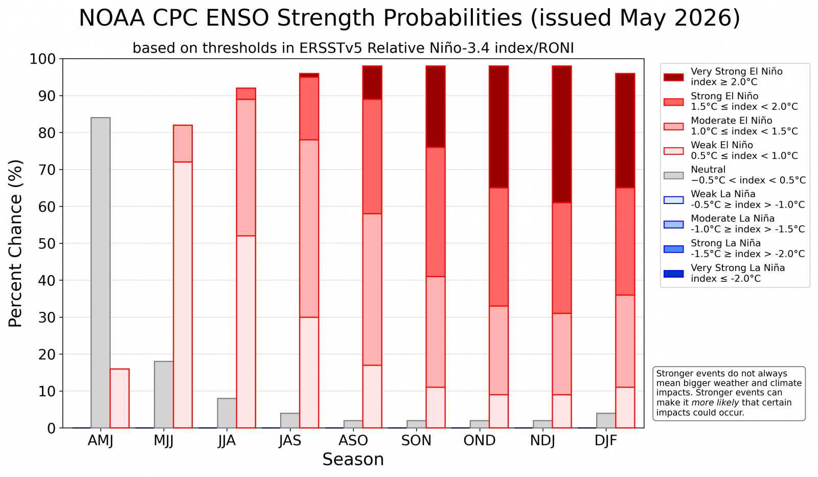
The El Niño Southern Oscillation (ENSO) is in its neutral phase as we enter June, but is expected to swing dramatically toward El Niño conditions this summer. Most ENSO forecast models suggest El Niño could become strong to exceptionally strong this fall.
|
Probabilities for ENSO strength through winter 2026-27. El Niño is predicted to develop this summer and become strong to perhaps very strong this fall. |
El Niño is the warm phase of a naturally occurring shift in tropical Pacific Ocean water temperatures called the El Niño Southern Oscillation (ENSO) that brings changes in rainfall and wind circulation patterns worldwide. El Niño's opposite is called La Niña, the cool phase of ENSO that brings shifts in weather and climate in largely the opposite direction.
> > > Read more about El Niño and La Niña from NOAA Climate Services
Research from NOAA's Physical Sciences Laboratory (PSL) shows there is little significant variation in local summer temperatures across North or South Carolina directly attributable to El Niño. There is a slight tendency for El Niño to bring drier-than-normal summer conditions from the Mid Atlantic states southward into eastern North Carolina, and a better tendency for wet summer weather across Florida and the Deep South during El Niño.
While some summers are hotter or cooler than others, El Niño/La Niña aren't the reason for those differences across North and South Carolina.
|
NOAA PSL summer temperature anomalies attributable to El Niño. El Niño has no significant impact on summer temperatures across the Carolinas |
 NOAA PSL summer rainfall anomalies attributable to El Niño. El Niño is associated with slightly drier-than-normal weather across the Mid Atlantic states. NOAA PSL summer rainfall anomalies attributable to El Niño. El Niño is associated with slightly drier-than-normal weather across the Mid Atlantic states. |
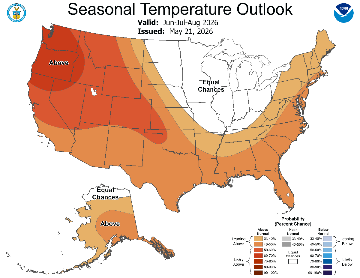
Official outlooks from the NWS's Climate Prediction Center show an increased potential for above normal temperatures this summer. Precipitation outlooks show "equal chances" of above, near, or below normal rainfall - an outlook category used when there is no clear signal among forecast models or climate patterns to guide the forecast.
|
NWS Climate Prediction Center temperature outlook for the summer of 2026 |
NWS Climate Prediction Center precipitation outlook for the summer of 2026 |
CPC's Prognostic Discussion explains that their temperature and precipitation outlooks were based on climate models, influences from soil moisture anomalies, and trends toward warmer temperatures as a consequence of ongoing climate change.
> > > Read more about Climate Change from NOAA
Hot summer temperatures can increase heat stress to people, animals, and plants. Warmer temperatures also increase the amount of energy needed for air conditioning, driving up costs to families and businesses. Each one-degree F increase in average summer temperature roughly equals a six percent increase in energy costs used for air conditioning. Computed cooling degree days are used to estimate how much energy is used for cooling throughout a day, a month, or a season.
Hurricane Season
NOAA's official Seasonal Hurricane Outlook calls for a below normal Atlantic Hurricane Season featuring 8 to 14 named storms, 3 to 6 hurricanes, and 1 to 3 major hurricanes. These forecast ranges are below long-term averages (14 named storms, 7 hurricanes, and 3 major hurricanes) due to anticipated impacts from the developing El Niño.
Hurricane season officially starts on June 1 and continues through the end of November.
 |
Sea surface temperatures are slightly above normal across the tropical and subtropical Atlantic Ocean including the Gulf and Caribbean. Parts of the Atlantic north of Bermuda are running colder than normal, as is the eastern Atlantic Ocean near the African coast. As a whole, the Atlantic is still above normal but nowhere near the extreme warmth noted by this point in 2023 and 2024.
|
Shades of yellow, orange, and red indicate warmer-than-normal ocean water. Source: NOAA Coral Reef Watch |
Last fall and winter featured a La Niña climate pattern. Eastern tropical Pacific sea surface temperatures recently have returned toward normal and are expected to rapidly warm this summer. This should trigger the start of a strong to very strong El Niño that will last through the upcoming winter season.
During the summer and fall, El Niño increases wind shear across the tropical Atlantic which can reduce the number and intensity of Atlantic tropical cyclones. This anticipated El Niño is the primary reason why the official NOAA seasonal outlook is for below normal tropical cyclone activity across the Atlantic Ocean this year.
During the past five years where El Niño conditions either developed during the summer or were already in place, four years still saw impacts from tropical storms and hurricanes across the area.
|
Local tropical cyclone impacts during the past five El Niño years: 2023, 2015, 2009, 2006, 2004 |
|
|
Coastal Flooding Risk
The largest astronomical tides of the summer will occur in the days surrounding a New Moon on June 14. This is the time when minor coastal flooding will be most possible even without the benefit of a storm in the area. New Moons on July 14 and August 12 will also create larger tides, but likely insufficient on their own to produce coastal flooding.
|
Astronomical Tide Predictions for the of Summer 2026 |
Significant coastal flooding is almost always the consequence of strong winds from a tropical cyclone or large Nor'easter creating a storm surge. When a storm occurs at the same time as high astronomical tides, water levels and the impacts from the flooding will be greater.
The Monthly High Tide Flooding Outlook from the National Ocean Service has more details about each month's coastal flooding risk.
Wildfire Risk
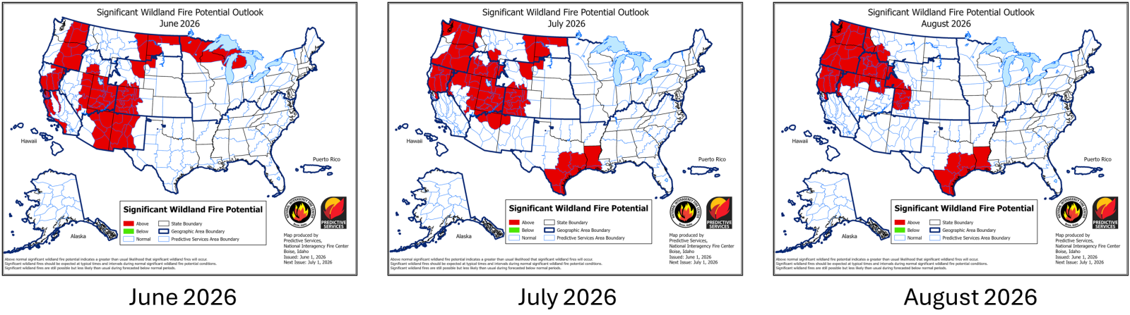
Forecasters with the National Interagency Fire Center (NIFC) monitor trends in drought, fuel moisture, and plant growth to create maps highlighting the hazards posed by wildfire. Their outlook shows a near-normal risk of wildfire across all portions of North and South Carolina throughout the summer season.
|
NIFC Wildland Fire Potential Outlooks for June through August 2026 |
NIFC's forecast discussion accompanying the graphics notes there is uncertainty about how much rainfall the South will see later this summer since El Niño tends to reduce the number of tropical cyclones. From their discussion:
| With the El Niño-Southern Oscillation (ENSO) transitioning from the neutral phase to an El Niño pattern, the forecast is for below normal tropical storm activity for this year's Atlantic hurricane season. However, warm sea surface temperatures may allow for the season to be just below normal, with the beginning of the season more active than the end, as the strengthening El Niño becomes more effective in curtailing tropical storm development. The lack of tropical moisture coming into the Southern Area could have the effect of below normal rainfall later in the summer, which could lead to more drought conditions and higher than normal fire activity in some areas, especially in those areas significantly affected by drought this year already. This will lead to greater uncertainty in the forecast for fire activity through the summer. |
Avoid outdoor burning on days when recent dry weather, low relative humidity, and gusty winds coexist. Check our latest Fire Weather Forecast to see if weather conditions will allow safe burning.
Other Links of Interest
Research and Page Author: Tim Armstrong
Last Updated: June 9, 2026








 Radar
Radar Current Weather
 Rivers & Lakes
 Satellite
 Forecast Maps
 Hour by Hour Forecast
 Tropical Weather
 Graphical Hazards
 Weather Hazard Briefing
 Forecaster's Discussion
 Text Bulletins
 Climate
 Skywarn
 NOAA Weather Radio
 Sunrise/Sunset
 Marine Forecasts
 Beach & Surf
 Coastal Flood
  Follow us on X
 Follow us on Facebook
 Follow us on YouTube
 ILM RSS Feed