|
|
|
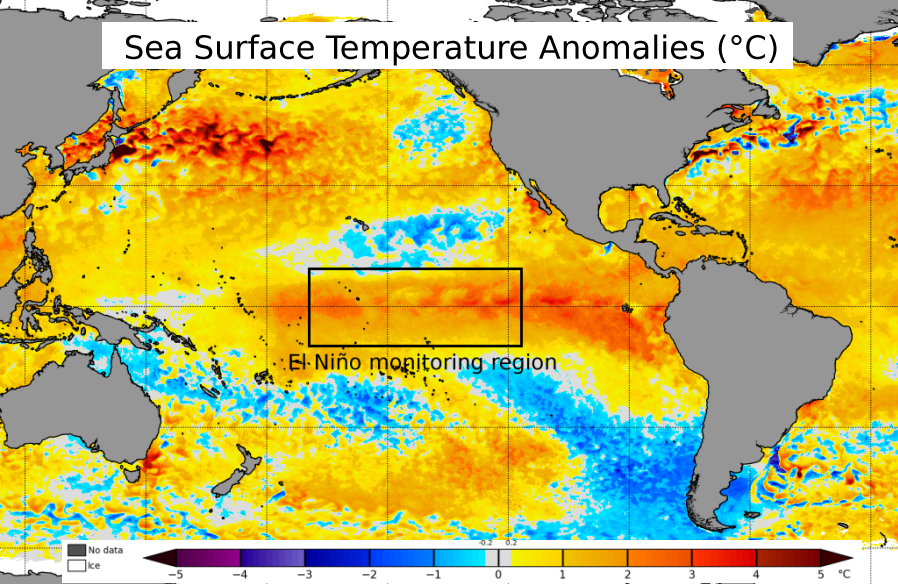
Ocean temperature anomalies in mid Nov 2023 |
For the first time in four years, El Niño has returned and should be the controlling factor for this winter's weather across North and South Carolina.
El Niño is natural, periodic warming of ocean water across the tropical east Pacific Ocean that brings global impacts to temperatures, rainfall, wind, and pressure patterns. El Niño is known during the summer and fall for its suppressing influence on Atlantic tropical cyclone activity, but often brings its largest impacts to the Carolinas during the winter when it increases the potential for above normal rainfall across the southern United States.
The last two strong El Niño events, 1997-1998 and 2015-2016, both brought exceptional rainfall totals across the coastal Carolinas. Over 23 inches of rain fell in Wilmington between December 1997 and February 1998 -- our wettest winter season in over 150 years of records. Given the moderate to severe drought conditions that are currently in place over large portions of the Carolinas, an outlook of increased chances for substantial rainfall is very good news.
Learn more about El Niño from the National Ocean Service...
|
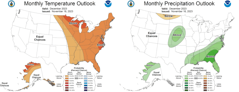
Monthly and seasonal temperature and precipitation outlooks from the NWS Climate Prediction Center for the winter of 2023-2024 |
Rainfall
Winter outlooks from the NWS Climate Prediction Center show an increased potential for above normal precipitation totals during the month of December. For the remainder of the winter (January and February) the potential for above normal precipitation increases further: across eastern North and South Carolina there is a 70 percent chance that this winter's precipitation totals will reach the upper one-third of historical measurements, and only a 3 percent chance that they will fall within in the lowest one-third.
| Wilmington, NC | Florence, SC | N. Myrtle Beach, SC | Lumberton, NC | |
| 1991-2020 Average Winter Precipitation Total | 10.97" | 9.55" | 9.29" | 8.63" |
| El Niño Average Winter Precipitation | 13.45" (+2.48") | 11.28" (+1.73") | 12.27" (+2.98") | 10.54" (+1.91") |
| Neutral ENSO Average Winter Precipitation | 11.13" (+0.16") | 9.55" (+0.00") | 8.49" (-0.80") | 10.08" (+1.45") |
| La Niña Average Winter Precipitation | 8.72" (-2.25") | 8.21" (-1.34") | 8.20" (-1.09") | 7.95" (-0.68") |
An increase in winter rainfall totals is the single largest impact El Niño typically brings to the eastern Carolinas.
Moderate to severe drought has developed across large portions of the southeastern United States including North and South Carolina due to unusually dry weather since summer. The U.S. Drought Monitor shows 48 percent of South Carolina and 72 percent of North Carolina is experiencing moderate or worse drought conditions as of mid November. In Wilmington, 90-day rainfall totals are nearly seven inches below normal. Over the past month less than one inch of rain has fallen in Florence, SC and Lumberton, NC.
|
The U.S. Drought Monitor valid for mid November, and the CPC outlook for drought during the winter 2023-2024 season. Moderate drought currently ongoing across portions of the eastern Carolinas is forecast to improve this winter due to plentiful rainfall. |
El Niño increases the odds that substantial rainfall will occur this winter. Should this outlook verify, the ongoing drought should improve and may completely end before spring arrives.
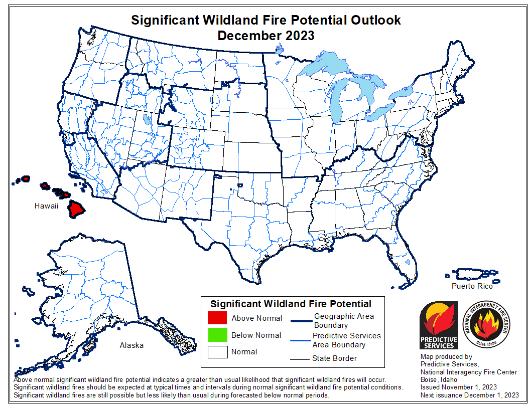
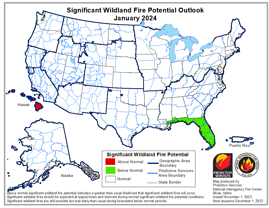
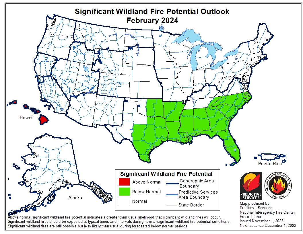
Another positive aspect of this winter's El Niño should be a lessening of the risk of wildfire. According to the most recent outlook from the National Interagency Fire Center, expected ample precipitation through the winter should lead to a below normal risk of wildfire across the Southeast, including the Carolinas, by February.
|
Wildland Fire Outlook for December 2023 |
Wildland Fire Outlook for January 2024 |
Wildland Fire Outlook for February 2024 |
Temperatures
The difference in average seasonal temperature between El Niño, ENSO-neutral, and La Niña winters is not especially large. In general, El Niño winters are slightly cooler than either La Niña or neutral winters for local cities.
| Wilmington, NC | Florence, SC | N. Myrtle Beach, SC | Lumberton, NC | |
| 1991-2022 Average Winter Temperature | 48.6° | 48.2° | 48.5° | 46.3° |
| El Niño Average Winter Temperature | 48.0° (-0.6°) | 47.5° (-0.7°) | 48.2 (-0.3°) | 45.9 (-0.4°) |
| Neutral ENSO Average Winter Temperature | 49.4° (+0.8°) | 49.1° (+0.8°) | 49.3 (+0.8°) | 46.6 (+0.3°) |
| La Niña Average Winter Temperature | 48.5° (-0.1°) | 48.0° (-0.2°) | 48.1 (-0.4°) | 46.4 (+0.1°) |
El Niño does not appear to bring a significant increase in the number or severity of arctic outbreaks this far south. Instead, the decrease in average temperature appears to be more related to a larger number of cool, cloudy winter days during El Niño. This is due to the jet stream usually shifting farther south during El Niño winters, plus an increase in the amount of moisture carried northward by the subtropical jet stream. A more detailed explanation is provided on Climate.gov.
|
Warm tropical east Pacific ocean water during El Niño creates thunderstorms which feed moisture northward toward the Carolinas via the subtropical jet stream. This lead to additional cool, cloudy days locally. |
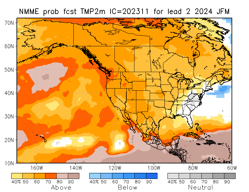
North American Multimodel Ensemble (NMME) temperature forecast for January through March. CPC is forecasting an enhanced potential for above normal temperatures in December, then CPC and the model ensemble show near-normal temperatures for the remainder of the winter into March. |
Snow
|
January 28-29, 2014 snowstorm in Wilmington, NC |
Snow is an uncommon occurrence across eastern North and South Carolina. Not every winter sees measurable snow occur, and when it does amounts are typically small. Major snowstorms (six or more inches of snow) haven't occurred in Wilmington since December 1989 and since January 2000 in Florence, SC.
Epic snowstorms where a foot or more of snow has fallen have occurred only three times in Wilmington's history: February 17-18, 1896; February 9-11, 1973; and December 22-24, 1989. In Florence, SC, where climate records only extend back to 1948, only the Feburary 1973 snowstorm has produced over a foot of accumulation.
Since 1950, 50 percent of El Niño winters (13 out of 26) saw at least some measurable snowfall (0.1 inches or greater) in Wilmington and Florence. But despite the rather meager probability of snow, El Niño winters collectively have had the highest average snowfall totals, larger than those observed during ENSO-neutral or La Niña winters.
Examination of the climate record shows major snowstorms in February 1973, March 1980, and January 1988, all while El Niño was occurring, were primarily responsible for this bump in historical averages.
| El Niño chance of measurable snow | Neutral chance of measurable snow | La Niña chance of measurable snow | El Niño avg snowfall | Neutral avg snowfall | La Niña avg snowfall | ||
| Wilmington, NC | 50% | 58% | 54% | 1.9" | 1.7" | 1.3" | |
| Florence, SC | 50% | 74% | 43% | 2.4" | 2.1" | 1.3" |
When sufficient cold air is present, the enhancement in precipitation frequency and totals that El Niño brings can help produce a significant snowstorm here across the eastern Carolinas. But tempering our expectations for this winter: the most recent 30-year period used for climate normals (1991 through 2020) has the smallest average snowfall for any time in Wilmington's climate record, only 0.9 inches per year. This is likely related to ongoing climate change which has led to warmer temperatures.
|
Wilmington, NC's complete annual snowfall history since 1871 with calculated 30-year normals. The average annual snowfall of only 0.9 inches during the period 1991 to 2020 is the smallest on record. |
"How does El Niño affect snowfall over North America?" from Climate.gov
Tides and Coastal Flooding
Predicted astronomical tides will remain rather small through February. The highest astronomical tide of the season will occur December 13-14 at only 6.17 feet MLLW at Myrtle Beach and 5.05 feet MLLW at Wrightsville Beach. This is almost one foot below minor flood stage at both beaches, and means there would need to be a rather large tidal anomaly produced by weather systems (onshore wind or nearby strong low pressure) to produce coastal flooding.
|
Nor'easter of November 6-8, 2021 |
However research from the U.S. Naval Academy shows that El Niño can help to increase the number of strong winter storms, often called Nor'easters, along the Atlantic coast. Depending on the strength and their precise storm track, Nor'easters can create significant coastal flooding due to strong onshore winds that continue across several tide cycles.
A Nor'easter on January 1, 1987 produced severe impacts along the North Carolina coastline. The Wilmington Star-News reported "a three-quarter mile stretch of South Topsail Island was under up to 3 feet of water" and that flooding was observed on streets in Wrightsville Beach. This occurred during an El Niño winter.
Hourly forecasts for water levels at Wrightsville Beach, Myrtle Beach, and the Cape Fear River at downtown Wilmington are available on the Advanced Hydrological Prediction Service webpage. These forecasts are made by NWS meteorologists and include storm surge and tidal anomalies.
Additional Links
Research and Page Author: Tim Armstrong
Last Updated: November 20, 2023


.jpg)

 Coastal Flood