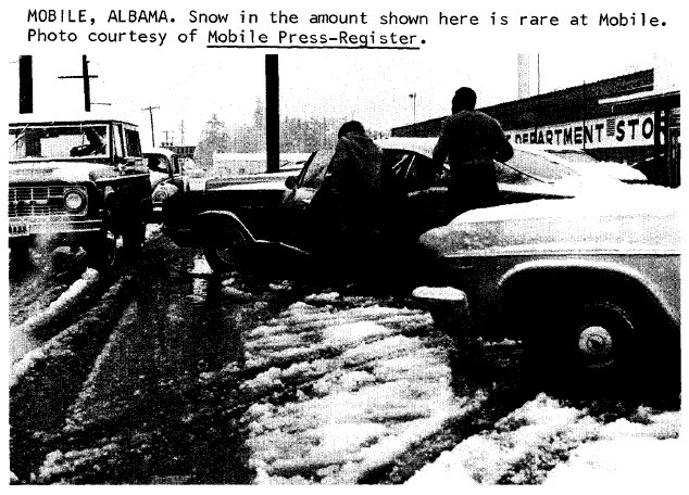
One of the greatest snowstorms in Southeastern United States history occurred February 9-11, 1973. This storm dropped one to two feet of snow across a region that typically sees only an inch or two of snow per year. New all-time snowfall records were established in a number of locations including Rimini, SC with 24 inches; 18 inches in Darlington, SC; and 16.5 inches in Macon, GA. Snowfall in Wilmington, NC reached 12.5 inches with 7.1 inches recorded in Charleston, SC, both setting all-time records which were broken just 16 years later during the Christmas snowstorm of 1989. Measurable snow fell along the Gulf Coast from Texas to Florida and flurries were reported as far south as Lisbon and Clermont, Florida just outside of Orlando.
Snowfall Totals by State. Click the state name to expand...
|
|
|
Meteorological History
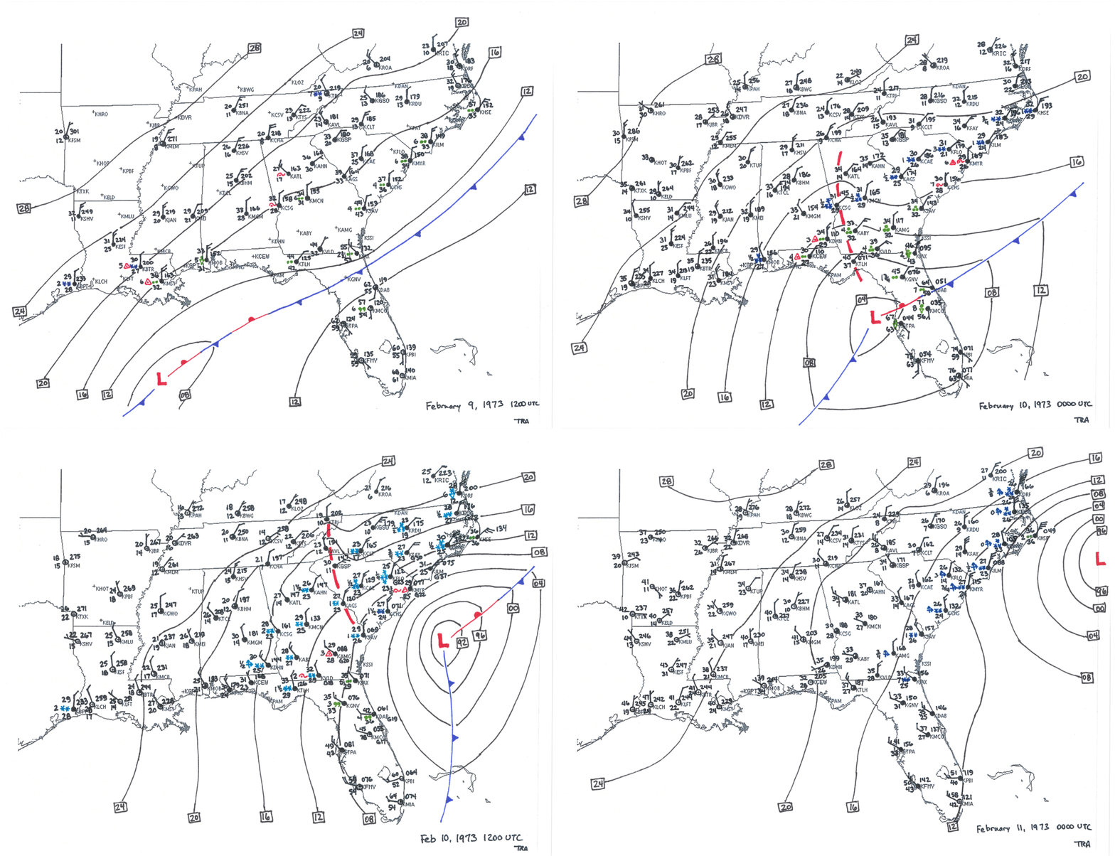
A cold front brought chilly air into the Southeastern states on February 8, 1973. This front moved off the Gulf Coast and into the Gulf of America that evening and low pressure began to develop along the stalled front that night. Winds spiraling around the developing low transported Gulf moisture northward over the cold air, and a mixture of sleet, snow, and freezing rain was reported from coastal Texas through Louisiana by sunrise on February 9th.
 |
||||
|
The low moved east along the nearly stationary front in the Gulf and reached central Florida during the evening hours of February 9th. Ice changed over to snow before ending across southern Louisiana and Mississippi with isolated totals over 3 inches. Snow began to spread northeastward across Alabama, Georgia, and the Carolinas with freezing rain and sleet forming a transition zone across coastal South Carolina, Georgia and Alabama between the snow and rain. Snowfall totals across Alabama were heaviest in a narrow band between Dothan and Montgomery, including totals over a foot reported from the communities of Highland Home, Pittsview, and Union Springs.
The low strengthened quickly the morning of February 10th, dragging cold air southward across Georgia and Florida. This changed precipitation over to all snow as far south as Tallahassee, Florida; Valdosta, Georgia; and Savannah, Georgia. Moderate to heavy snow developed across central Georgia, most of South Carolina and eastern North Carolina. Thunder even accompanied the snowfall in Augusta, GA around 3 a.m., in Florence, SC at 6 a.m., Wilmington, NC at noon, and in New Bern, NC at 2 p.m. Snowfall rates increased to one to two inches per hour and held there for most of the day, producing a 50-mile wide stripe of snowfall totals over one foot extending clear across Georgia including 18.5 inches in Butler, 16.5 inches in Macon, and 14 inches in Columbus, Georgia. Interestingly the snow remained entirely south of Atlanta with only cloudy skies reported there.
The low continued to strengthen as it moved east of the North Carolina coast during the evening of February 10th. Snow began to taper off across Georgia and most of South Carolina, however light snow and flurries were carried south into the northern half of the Florida peninsula with measurable snow falling in Jacksonville. Wind gusts exceeded 40 mph and led to areas of blowing snow with visibility falling to near zero in many locations across eastern North Carolina during the evening of February 10th -- truly blizzard conditions in an area that hardly sees any snow in a typical winter. By the time the snow ended an amazing 24 inches had fallen in the Clarendon County town of Rimini, South Carolina. Other significant snowfall totals included 18 inches in Darlington, 17 inches in Florence, and 16 inches in Columbia, South Carolina. In eastern North Carolina 16.5 inches fell in Whiteville, 16 inches in Morehead City, 13 inches in New Bern, and 12.5 inches in Wilmington.
ATS-3 Satellite Data
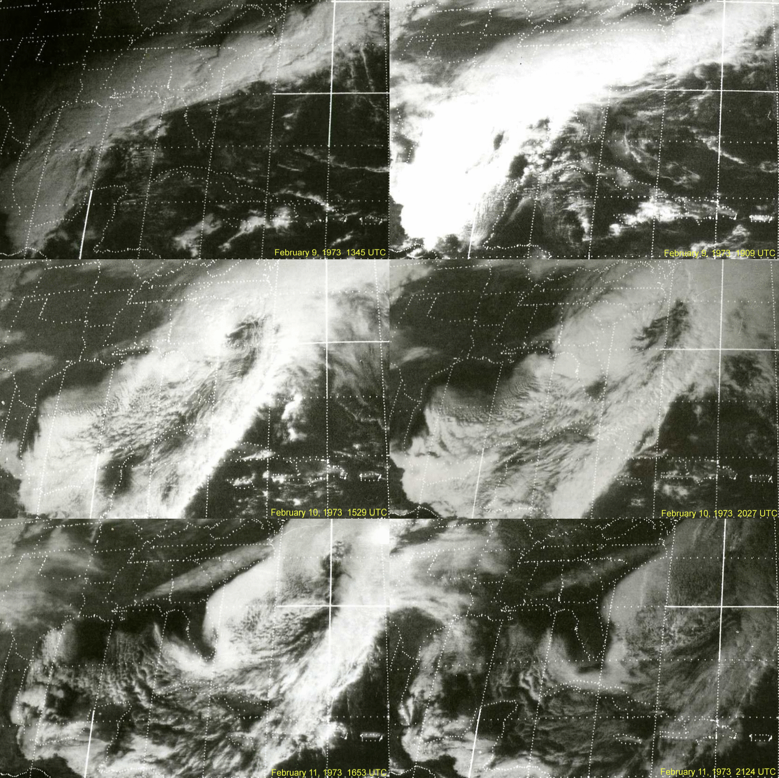
The GOES (Geostationary Operational Environmental Satellite) program didn't begin returning data until after the launch of GOES-1 in late 1975. However ATS-3, (Applications Technology Satellite-3) operated by NASA, was in orbit during the February 1973 snowstorm and provided visible imagery of the event every 30 minutes. Below is an animation produced from scanned hardcopies graciously provided by The Schwerdtfeger Library at The Space Science and Engineering Center (SSEC) of the University of Wisconsin. This animation covers the time span from February 9-11, 1973.

|
Impact
This storm shut down travel and isolated entire communities across south Alabama, central Georgia, South Carolina, and eastern North Carolina for several days. In some places over a decade's worth of snow fell in less than two days! A quote from the South Carolina state climatologist, reprinted in a storm summary from the National Climatic Data Center, sums up the situation well:
"About 30,000 tourists traveling to or from Florida and more northern states, were stranded on the State's highways. Many were rescued by helicopter and some by other vehicles. When the hotels and motels were filled, they were housed in armories, schools, and churches. Farmers gave aid to travelers stranded near their homes. Many farm homes had 50 to 60 unexpected guests for a day or two." The snow was accompanied by strong winds and followed by severe cold. Drifts up to 7 or 8 feet could be found in same locations and all highways in the central part of the State were closed for from 2 to 4 days. Many tons of food and supplies were airlifted by helicopter to snowed-in families. At least 200 buildings collapsed, as did thousands of store awnings and carports..."
 The s
The snowfall totals in this event were so large they completely overwhelmed the meager snow removal equipment available. School children in Montgomery County, Alabama had to spend a night in their classrooms as snow fell so heavily buses could not safely take them home. In Forsyth, Georgia around 1,000 travelers sought shelter, most of whom were traveling south toward Florida along Interstate 75. I-75 was closed along an almost-200 mile stretch from central Georgia to near the Florida border, with state troopers estimating there were "thousands of stranded cars" along the highway. In Macon, Georgia every road was closed at the height of the storm and the city's mayor declared a curfew and a state of emergency. The cities of Columbus, Georgia and Phenix City, Alabama suffered similar impacts.
Snow drifts up to 8 feet height were reported in central South Carolina and virtually all roads were closed for two to four days. Helicopters were used to airlift food to stranded residents. In Columbia two roofs collapsed due to the weight of the snow. Nighttime temperatures dipped as low as 5 degrees in Columbia, SC after the storm.
Interstate 95 was closed in Fayetteville, North Carolina, where approximately 1,000 travelers became stranded. At the height of the storm 1,600 people in Fayetteville took advantage of emergency shelters at the National Guard Armory and a nearby auditorium. The Raleigh airport was closed for part of two days due to snow. NC Highway 12 on the Outer Banks was overwashed and buried by sand. The town of Buxton lost up to 200 feet of beach in spots with several houses and hotels damaged or destroyed. Even in "sunny" Florida, the Florida Highway Patrol reported a traffic fatality on an icy bridge in the panhandle region.
The Sumter Daily Item newspaper reported at least 11 exposure-related fatalities in South Carolina. Traffic accidents claimed three lives in Georgia and at least one in Louisiana. In North Carolina a small airplane crashed during the storm killing two and seriously injuring three people.
Agricultural impacts included collapsed chicken houses and dead birds with $3 million in damages in South Carolina alone. Heavy accumulations of freezing rain across parts of southern Alabama caused significant damage to pine plantations with substantial losses, including $1 million dollars in damages just in Covington County. In Florida winds and waves from the storm sunk a tugboat towing a 2,300 ton molasses tanker. The Coast Guard and a nearby yacht rescued the tug's eight crewmen.
Offshore the rapidly strengthening storm created strong winds and very large waves. The Frying Pan Shoals Tower, then a Coast Guard Light Station, recorded wind gusts of 75-80 mph and waves over 20 feet high. A Coast Guard vessel Gresham stationed off the coast of southern New Jersey recorded a wind gust to 90 mph.
Interestingly, this was the second snow of the winter for Baton Rouge, Louisiana and for parts of the Florida panhandle, both extremely unusual events.
Newspaper Reports
The following is a collection of publicly available newspaper articles published during and after the snowstorm from the Gadsden Times (Gadsden, Alabama), the Sarasota Herald (Sarasota, Florida), the Lakeland Ledger (Lakeland, Florida), the Sumter Daily Item (Sumter, South Carolina), and the Spartanburg Herald (Spartanburg, South Carolina).
Personal Stories
Long-time residents of the Carolinas, Georgia, and Alabama have vivid memories of this snowstorm which paralyzed the region for many days. Here are a few we've collected. If you remember this storm and have memories, pictures, or video you would like to share, please send an email using the link at the bottom of this page.
Kitty Fitzgibbon, Wilmington, NC television and radio personality
Was living in the Carolina Apartments (5th St. and Market St). I was used to driving in snow, and my '63 Valiant was light enough to get out and about on the snow/ice pack. Ended up bringing "care packages" to my Mom (in Bayshore) and several friends that were housebound for several days. Even had WPD help me get the car out of a snowdrift for the "mercy missions" on more than 1 occasion. (Great Times for me...quiet, isolated, Beautiful...Recently back from the Northeast...i.e. NYC.) I remember it being a double event, lots of snow that melted, partially, and became ice, and then a second snowfall that topped the ice and became truly treacherous within a day or 2. Anyway, it was an Event Extraordinaire! (Also walked to one of the downtown movie theaters through the drifts to see "Jeremiah Johnson" with Redford. I was the only person in the theater. Won't soon forget That One.)(Still wonder who the poor projectionist was.) Felt like the St. Bernard in the Alps for a day or so....And then later we had '89.... Interesting times....(Little wonder that I later became a weather forecaster.)
Kathy Martin of Loris, South Carolina
I was going to Conway Tech at the time. Got sent home early and snowed in for most of the week
Gary Hollar of Gary's Nursery in New Bern, North Carolina
I was trapped at my job at DuPont in Kinston for three days. Two feet deep. No one was able to get into the plant, even the National Guard, who tried to bring us cots and blankets, couldn't get there. We had to work almost around the clock the first two days until relief workers could make it in. Double pay around the clock while we were there but I just wanted to go home. Most miserable days I ever spent.
Stan McKenzie of McKenzie Farms in Florence County, South Carolina
I sure do remember it! There was so much snow that the roofs of many chicken houses and tobacco warehouses collapsed! The stench of all those rotting chickens is something that is stamped on my memory! We were stranded with no way of transportation for a long time due to the depth of the snow! An event I will never forget!
Ned Rahn of Port Royal, South Carolina
I was a firefighter at the time, and got off duty that morning. I could barely make my way home, because the road was covered and it was hard to make out were it was. I just creeping along and hoped I didn't run in a ditch - luckily I made it.
Danny Elliott, formerly of Warner Robins, GA
I was a 12-year old boy who’d spent his entire life living in Warner Robins, GA, host city of Robins Air Force Base. You can imagine the overwhelming thrill that I and my friends experienced during this time. My memory is that the cold temperatures remained several days after the snow, keeping us out of school for nearly a week.
While the Middle Georgia area isn’t hilly, is general, there are relatively short but steep hills in the area surrounding my home. With so many Air Force families from around the country living around us at the time, the number of sleds, skis, and other snow “toys” were abundant. It was the most memorable experience of my youth. Even today at 55 and living in the western half of North Carolina (for the past 4+ years), when snow falls, that 12-year old kid always comes back to life. And the memories of that storm come back as well.
Ann Weaver
Remember it well....I was living in Columbia at the time, but it collapsed my parent's brand new carport in Darlington County. Never have seen a snow like that one here since...once in a lifetime I hope!
Shannon Carmichael
We had a photograph framed that hung on our wall of our house in Nichols, SC in a snow drift. I was 4 years old. I remember the feeling of the magic/danger of it.
Rick Beacham
My brother and I were waiting in our car while mom was in the Wilson's Grocery on Oleander Drive. ...when it started snowing.
John Boatman of Augusta, GA
I was 13 at the time. It started on Friday so we had the weekend to play in the snow. The big takeaway: having grown up in Augusta, never had seen anything like it before or since. Us kids in our neighborhood had the best time of our life in this winter wonderland. It was so much fun, I didn’t want to go home except to change out of wet clothes.
Patricia Caponi
Patricia provided a detailed account of traveling through South Carolina on her way to Florida during this record snowstorm
Videos
|
South Carolina ETV special report on the February 1973 snowstorm
|
Charleston, South Carolina
|
| Sumter, South Carolina | Macon, Georgia |
Additional Links
NOAA Technical Memorandum EDS NCC-2: Southeastern Snow Storm February 8-11, 1973 by William T. Hodge
Forty-year Anniversary Article from The State Newspaper in Columbia, SC
Forty-year Anniversary Article from The Augusta Chronicle newspaper in Augusta, GA
"Blizzard of '73" shocked, stranded South Carolinians from WIS TV in Columbia, SC
Local Snowfall History for Wilmington, Florence, and Myrtle Beach

Research & Page Author: Tim Armstrong
Page Created: February 9, 2016
Last Updated: May 24, 2020