Please join us in promoting severe weather safety during this year's "Severe Weather and Flood Preparedness Week". The National Weather Service asks emergency management, public safety officials, local media and Weather-Ready Nation Ambassadors to help join forces in improving the nation's readiness, responsiveness, and overall resilience against severe weather during the upcoming season.
Be sure to check out Severe Weather Climatology for NWS Wilmington, NC 1991-2021.
Each day this week, a different topic will be covered. Click on the tabs below for more severe weather preparedness information.
Overview
Severe Weather Preparedness Week Overview & Types of Severe Weather
Statewide Tornado Drill scheduled for Wednesday, March 11th at 9:00 AM.
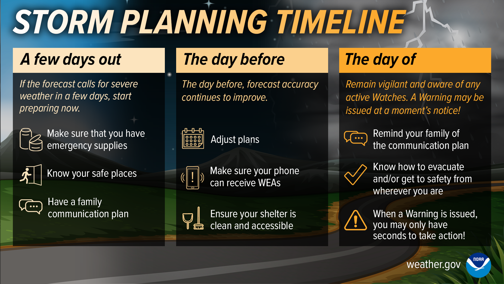
This week is South Carolina’s annual Severe Weather and Flood Preparedness Week. The South Carolina Emergency Management Division (SCEMD) and the National Weather Service jointly sponsor this week to remind people that severe storms, tornadoes and flash floods are significant hazards in South Carolina and people need to take proper safety precautions. With warmer weather quickly approaching, now is the time to prepare for the severe weather season. If each South Carolina resident would take a few moments this week to learn about severe weather and flood safety and implement a safety plan, then we would all be better off when severe thunderstorms, tornadoes, and flooding inevitably strike our state and the likelihood of injury and fatalities caused by severe weather and flooding could be minimized.
Severe weather and severe weather preparedness takes many forms, so each day this week we will highlight a different preparedness topic. This week’s topics will include…
| Day of The Week | Topics |
|---|---|
| Sunday | Types of Severe Weather |
| Monday | Watches and Warnings |
| Tuesday | Have Multiple Ways to Stay Connected |
| Wednesday |
What to do During a Tornado Statewide Tornado Drill |
| Thursday | FLOODING! Stats and Danger |
| Friday |
Turn Around, Don't Drown & Flooding home safety tips |
| Saturday | After the Storm (Storm damage reporting, recovery from storms and flooding, insurance, etc.) |
​
On Wednesday, March 11th at 9:00 AM, the National Weather Service in cooperation with local broadcasters will conduct a statewide tornado drill. The alarm test, which will come in the form of a Test Tornado Warning, will activate the State Emergency Alert System and be carried by local radio broadcasters. Every school, business, and residence is encouraged to participate in this drill. It’s really easy: at 9:00 AM on March 11th, take a few moments to practice your severe weather safety plan, and seek shelter for a few minutes as if a tornado was headed your way. Practicing this when the weather is good will allow you to react more quickly when the weather turns bad.
Please visit the South Carolina Emergency Management preparedness website scemd.org/prepare. On this web page you will find an abundance of information, and links to a free cell phone app, that will help you plan and prepare for the severe weather season.
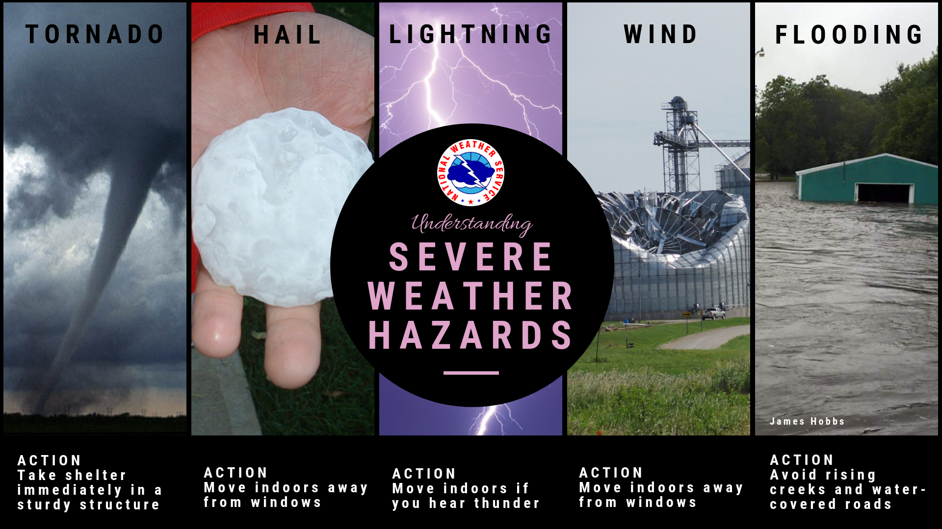
Types of Severe Weather
Severe Thunderstorms
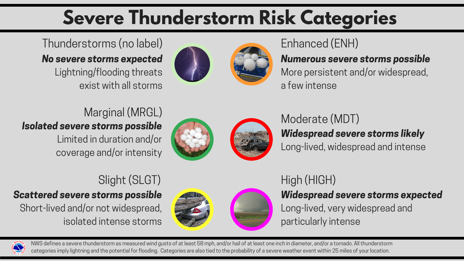
A thunderstorm is a local storm that produces lightning and thunder. Severe thunderstorms are officially defined as storms that are capable of producing hail that is an inch or larger or wind gusts over 58 mph. Hail this size can damage property such as plants, roofs, and vehicles. Wind this strong is able to break off large branches, knock over trees or cause structural damage.
Tornadoes
A tornado is a violently rotating column of air extending from the base of a thunderstorm down to the ground. Tornadoes are capable of completely destroying well-made structures, uprooting trees, and hurling objects through the air like deadly missiles. Tornadoes can occur at any time of day or night and at any time of the year. South Carolina averages 20-25 tornadoes a year statewide.
Lightning
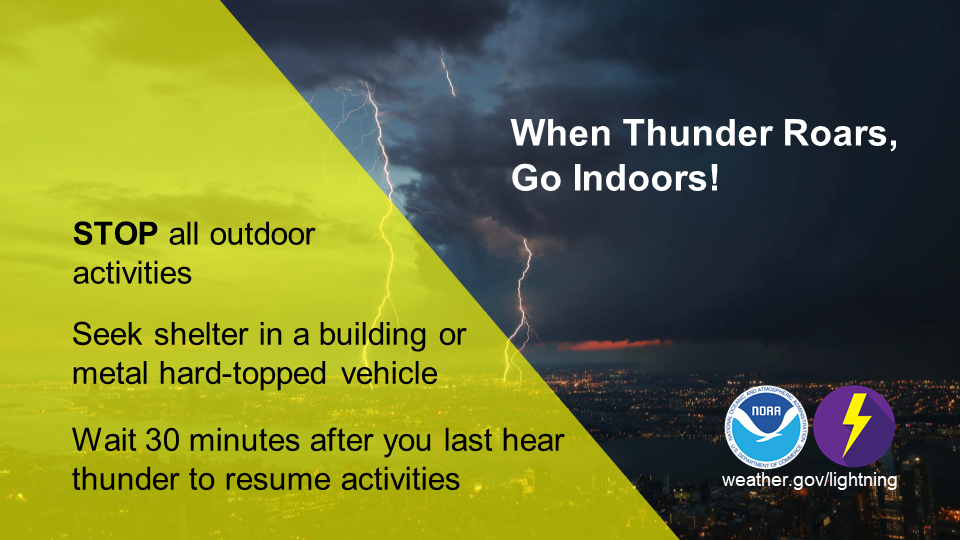
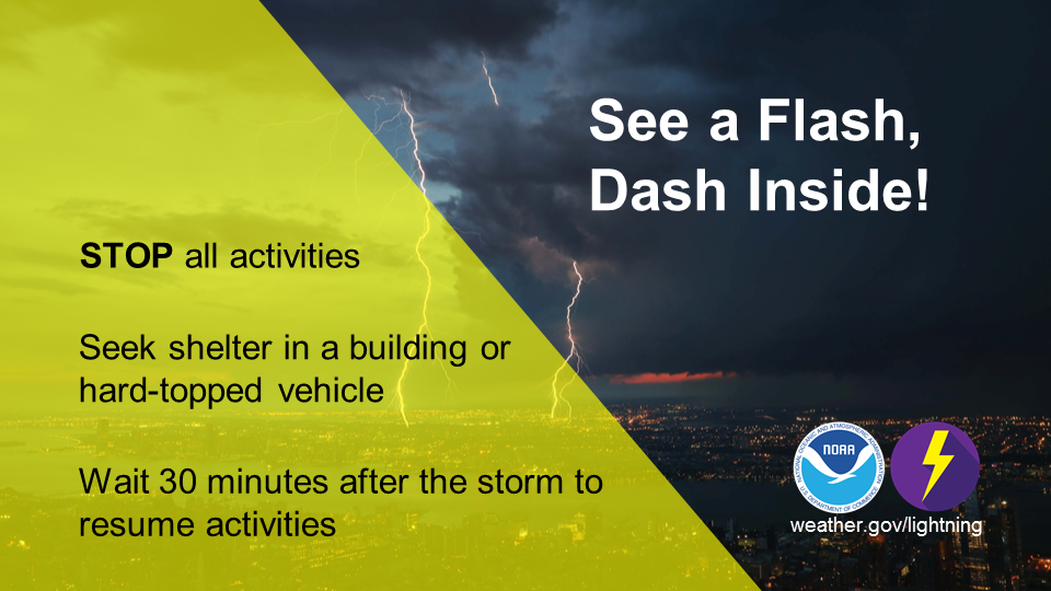
Lightning strikes the United States about 25 million times a year. Although most lightning occurs in the summer, people can be struck at any time of year. Lightning kills 20 or more people in the U.S. each year, and hundreds more are severely injured. Most of these tragedies can be prevented. When thunderstorms threaten, get inside a building with plumbing and electricity, or a hard-topped metal vehicle!
Flooding
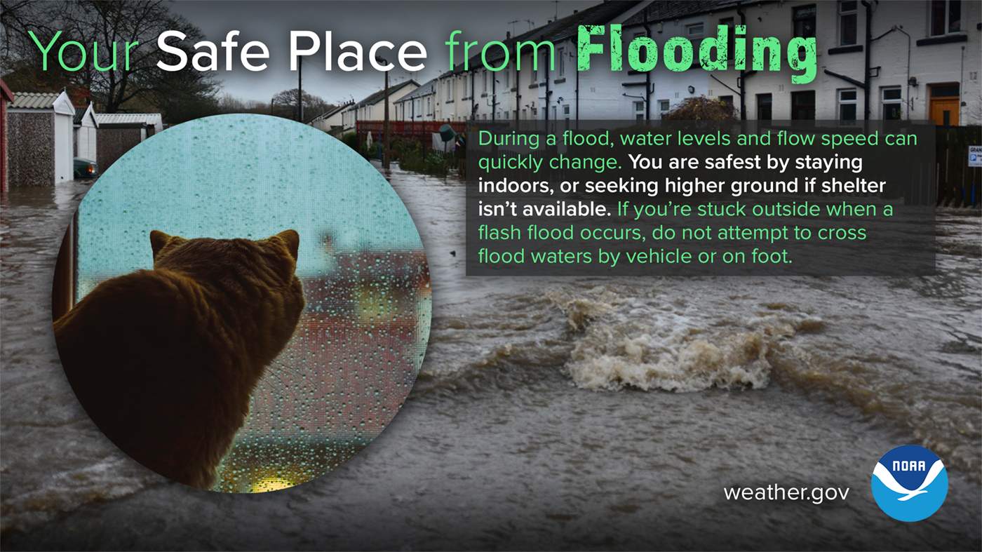
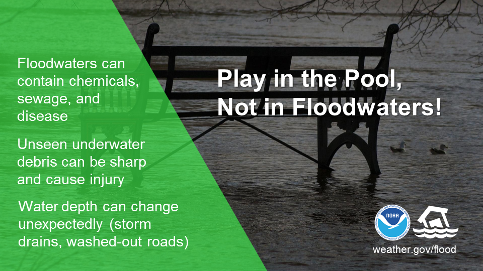
Flooding is the number one storm-related killer in the United States (and second weather-related killer behind heat). Why? Most people fail to realize the power of water. More than 50 percent of flood-related deaths are due to someone driving or walking into floodwaters.
Severe Weather & Flooding Infographics
 |
 |
 |
 |
 |
 |
USEFUL LINKS
Watches & Warnings
Watches and Warnings
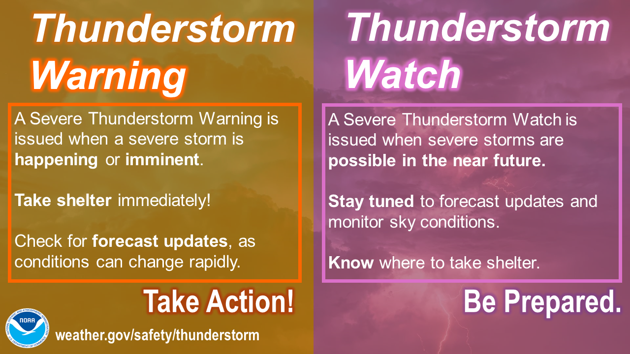
Do you know the difference between a National Weather Service Watches and Warnings for severe weather? These include Severe Thunderstorm, Tornado, and Flash Flood Watches and Warnings. A Watch means Be Prepared, as severe weather is possible in or near the watch area. A Warning means Take Action, as severe weather is expected imminently. Read more below about the various severe weather watches and warnings issued by the NWS.
Severe Thunderstorm Watch: Be Prepared! Severe thunderstorms are possible in and near the watch area. Stay informed and be ready to act if a severe thunderstorm warning is issued. Have multiple ways to receive warnings. The watch area is typically large, covering numerous counties or even states.
Severe Thunderstorm Warning: Take Action! Severe weather has been reported by spotters or indicated by radar. Warnings indicate imminent danger to life and property. Take shelter in a substantial building. Get out of mobile homes that can blow over in high winds.
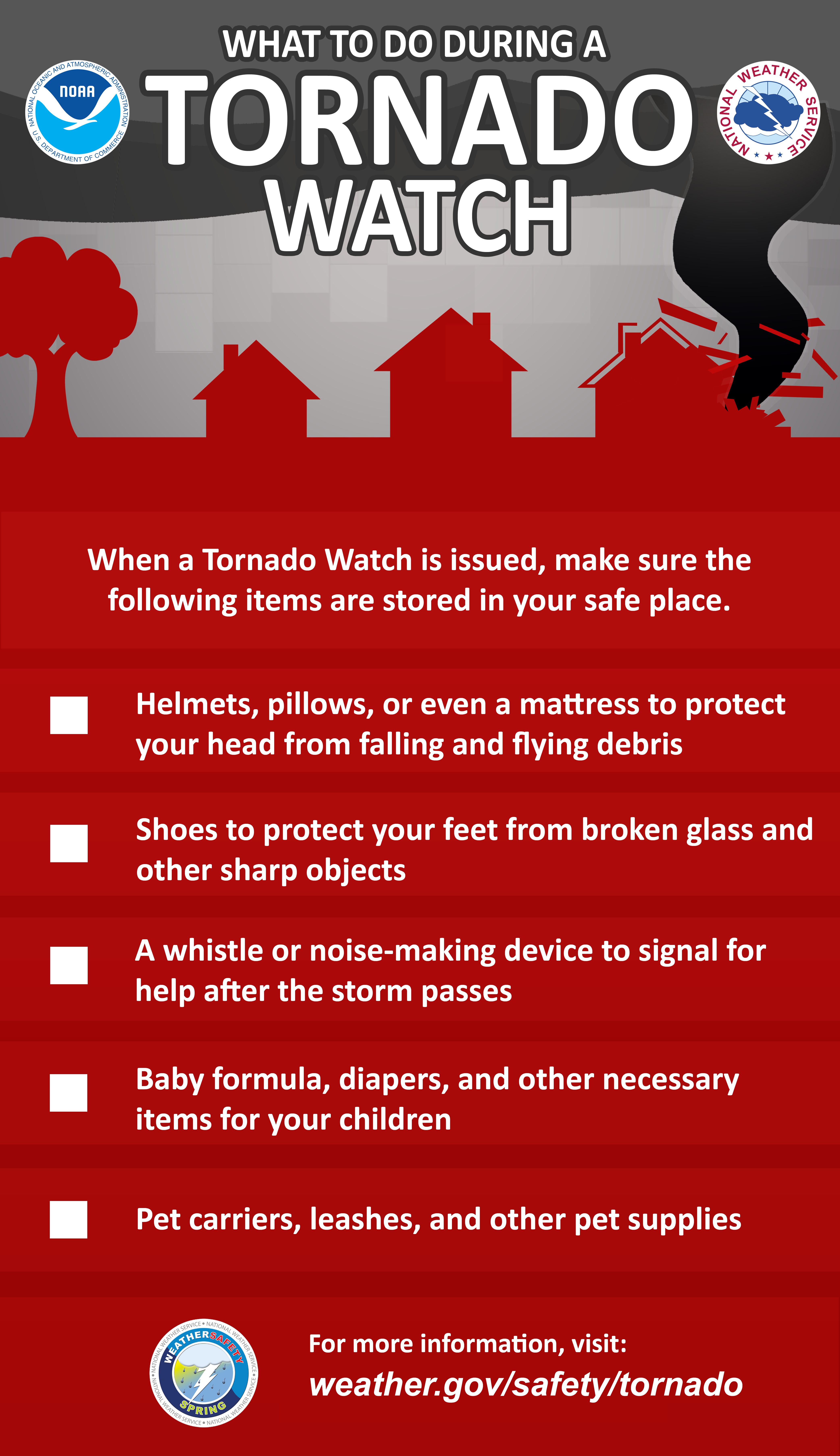
Tornado Watch: Be Prepared! Tornadoes are possible in and near the watch area. Review and discuss your emergency plans and check supplies and your safe room. Be ready to act quickly if a warning is issued or you suspect a tornado is approaching. Acting early helps to save lives! Have multiple ways to receive warnings. Watches are issued by the Storm Prediction Center for counties where tornadoes may occur, and typically covers a large area.
Tornado Warning: Take Action! A tornado has been sighted or indicated by weather radar. There is imminent danger to life and property. Move to an interior room on the lowest floor of a sturdy building. Avoid windows. If in a mobile home, a vehicle, or outdoors, move to the closest substantial shelter and protect yourself from flying debris.
Flash Flood Watch: Be Prepared! Flash flooding or flooding is possible within the watch area. Remain weather aware and be prepared to take action if a flash flood warning is issued for your area. Have multiple ways to receive warnings. Flood watches are issued by local NWS offices and typically encompass large areas.
Flash Flood Warning: Take Action! A flash flood is imminent or occurring. If you are in a flood prone area, move immediately to high ground. Never drive or walk through floodwaters. A flash flood is a sudden violent flood that can take from minutes to hours to develop. It is even possible to experience flash flood in areas not immediately receiving rain.
Watch & Warning - Infographics

Stay Connected
Have Multiple Ways to Stay Connected
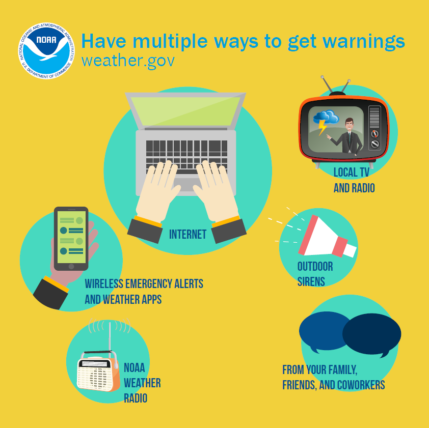
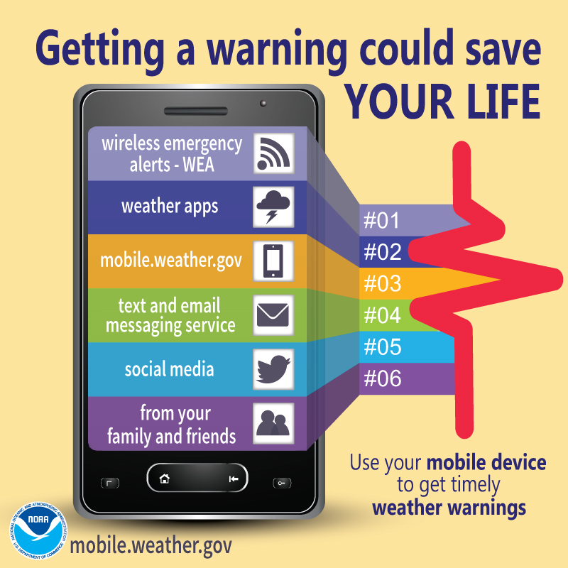
One of the keys to staying safe during the severe weather season is making sure that you have a way to receive lifesaving severe weather watches and warnings. There are many methods and tools, some of which are available with no cost or fees, that you can use to receive these important lifesaving alerts no matter where you are - at home, at school, or at work.
| Day of The Week | Topics |
|---|---|
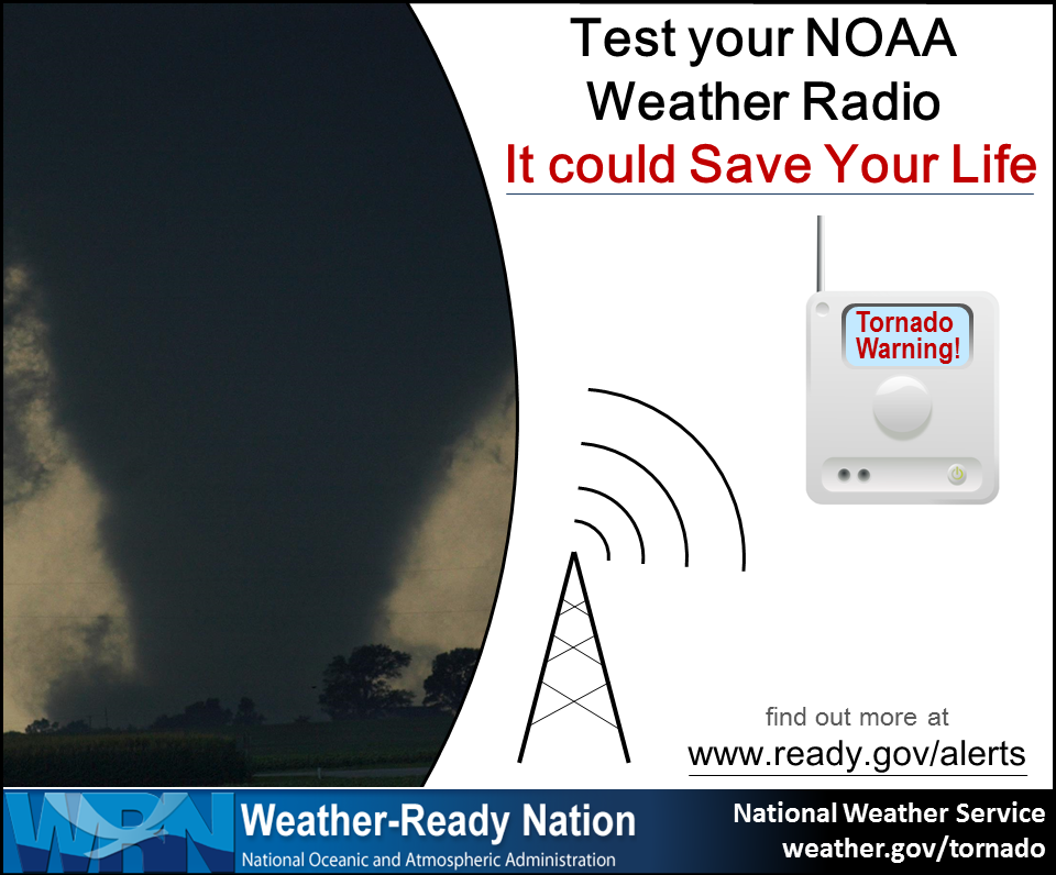
| NOAA Weather Radio (NWR) | NWR is a nationwide network of radio stations broadcasting continuous weather information from the nearest National Weather Service office. Specially built receivers, which can be purchased at most electronics and large retail stores for less than $40, receive the NWR broadcast 24 hours a day, 7 days a week, and sound an audible alert when official watches and warnings are issued for your area. Think of these radios as a “smoke detector” for severe weather alerts. |
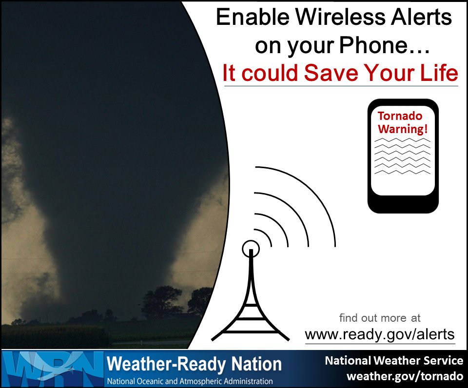
| Wireless Emergency Alerts (WEA) | With WEA, emergency alerts can be sent to your cell phone or mobile device when you may be in harm's way, without need to download an app or subscribe to a service. In addition to other alert types such as AMBER Alerts, this free service will transmit extreme weather warnings such as Tornado and Flash Flood warnings to your cell phone. The alerts will look like a text message, and will typically show the type and time of the alert, any action you should take. WEA messages include a special tone and vibration. If you receive a WEA message, you should follow any action advised by the emergency message. Seek more details from your favorite TV or radio station, NOAA Weather Radio, news website, desktop application, mobile application, or other trusted source of information. |
| Cell phone apps | There are many great cell phone apps that provide real-time NWS warnings and alerts, some of which are free to download and use, and others that may charge a small fee. A simple search of your app provider will reveal many of these apps. |
| Emergency Alert System (EAS) and your favorite TV and radio stations | EAS is the message dissemination pathway that sends warnings via broadcast, cable, satellite, and wireline services. EAS may be used by state and local authorities, including the National Weather Service, in cooperation with the broadcast community, to deliver important emergency information such as severe weather information, AMBER alerts, and local incident information targeted to specific areas. In short, when severe weather strikes, it’s a good idea to tune to your favorite local TV or radio station or web site for detailed information about the severe weather threat. |
In addition to the aforementioned alerting system, many communities also offer free emergency alert notifications through their own systems, such as reverse 911 phone systems. Be sure to check with your local emergency management agency to learn what is available in your area.
Receiving Severe Weather Alerts Infographics
 |
 |
 |
 |
Tornadoes
What to do During a Tornado (and Drill)
***On Wednesday, March 11th at 9:00 AM, the National Weather Service will conduct a statewide tornado drill***
The South Carolina tornado drill is conducted in close coordination with the South Carolina Broadcasters Association. The State Superintendent of Education is encouraging schools statewide to participate. The National Weather Service will use the Tornado Warning product on NOAA tone-alert weather radio when the drill is conducted. During the drill, the National Weather Service will use a real-event code, "TOR" on NOAA Weather Radio. The “TOR” code will activate tone-alert weather radios that are set to receive tornado warnings, and those radios will broadcast the exercise message.
The drill will be conducted Wednesday March 11th, at 9 a.m. Public schools, state and local Emergency Management, the South Carolina Broadcasters Association, and others will participate in this annual event. The purpose of the drill is to test communication systems, safety procedures, mitigation processes, etc.
During the drill:
What to Do Before a Tornado
Be alert to changing weather conditions, listen for latest weather information, and be prepared to take shelter immediately if a Tornado Warning is issued, or you observe any of the following danger signs:
What to Do During a Tornado
When your area is under a tornado warning, or if you see a tornado approaching, you should seek shelter immediately! Most injuries associated with high winds are from flying debris, so remember to protect your head. The following are safety tips for seeking shelter during tornadoes.
If you are in a home or small business:
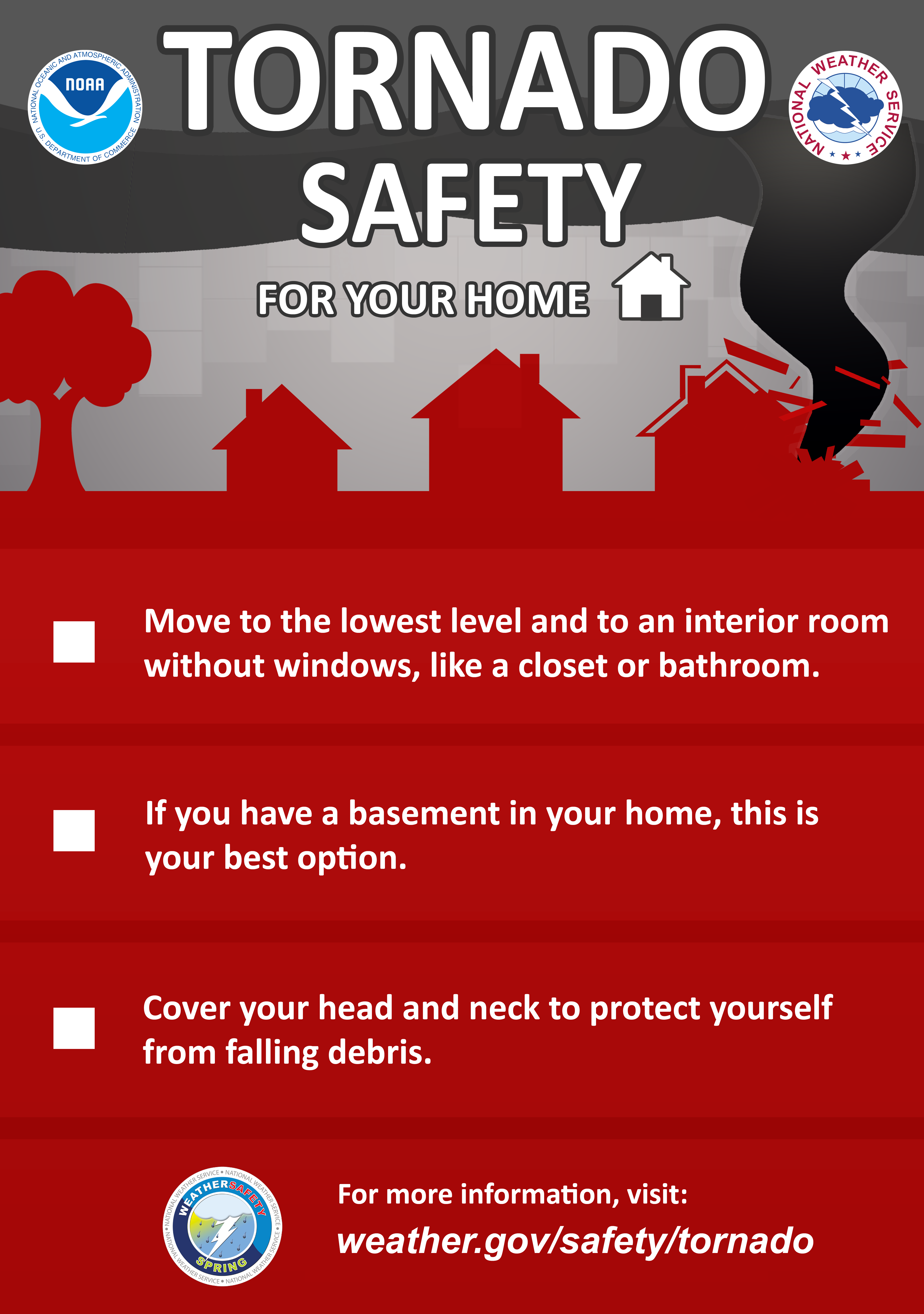
Go to the basement or a small interior room such as a closet, bathroom or interior hallway without windows on the lowest level. Put as many walls between yourself and the outside as possible. If possible, get under something sturdy, such as a heavy table, or use a mattress to protect yourself from flying debris. Most injuries associated with high winds are from flying debris, so remember to protect your head. If available, put on a bicycle or motorcycle helmet to protect yourself from head injuries.
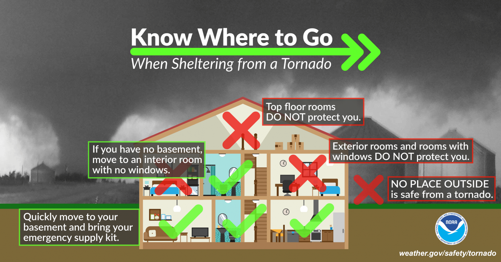
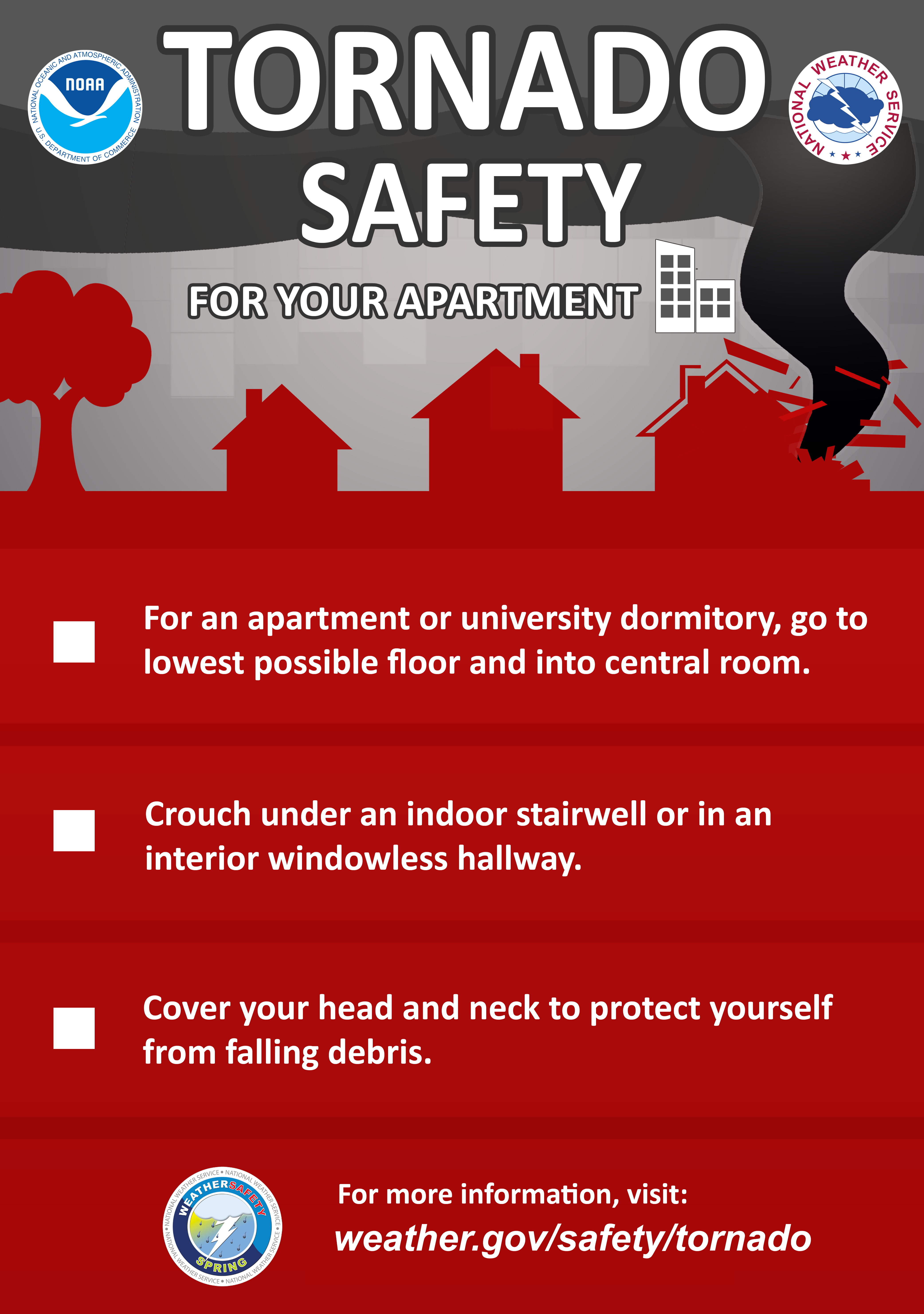
If you are in a large business, school, hospital, shopping center or factory:
Go to the designated shelter area. If a shelter area is not available, the best place is to go to an interior hallway on the lowest level. Stay away from the structurally weaker portions of buildings, such as windows and rooms with expansive roofs, which are more likely to collapse when tornadoes strike.
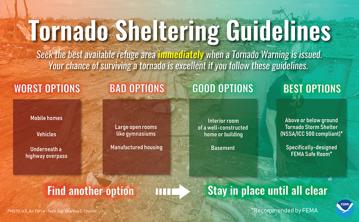
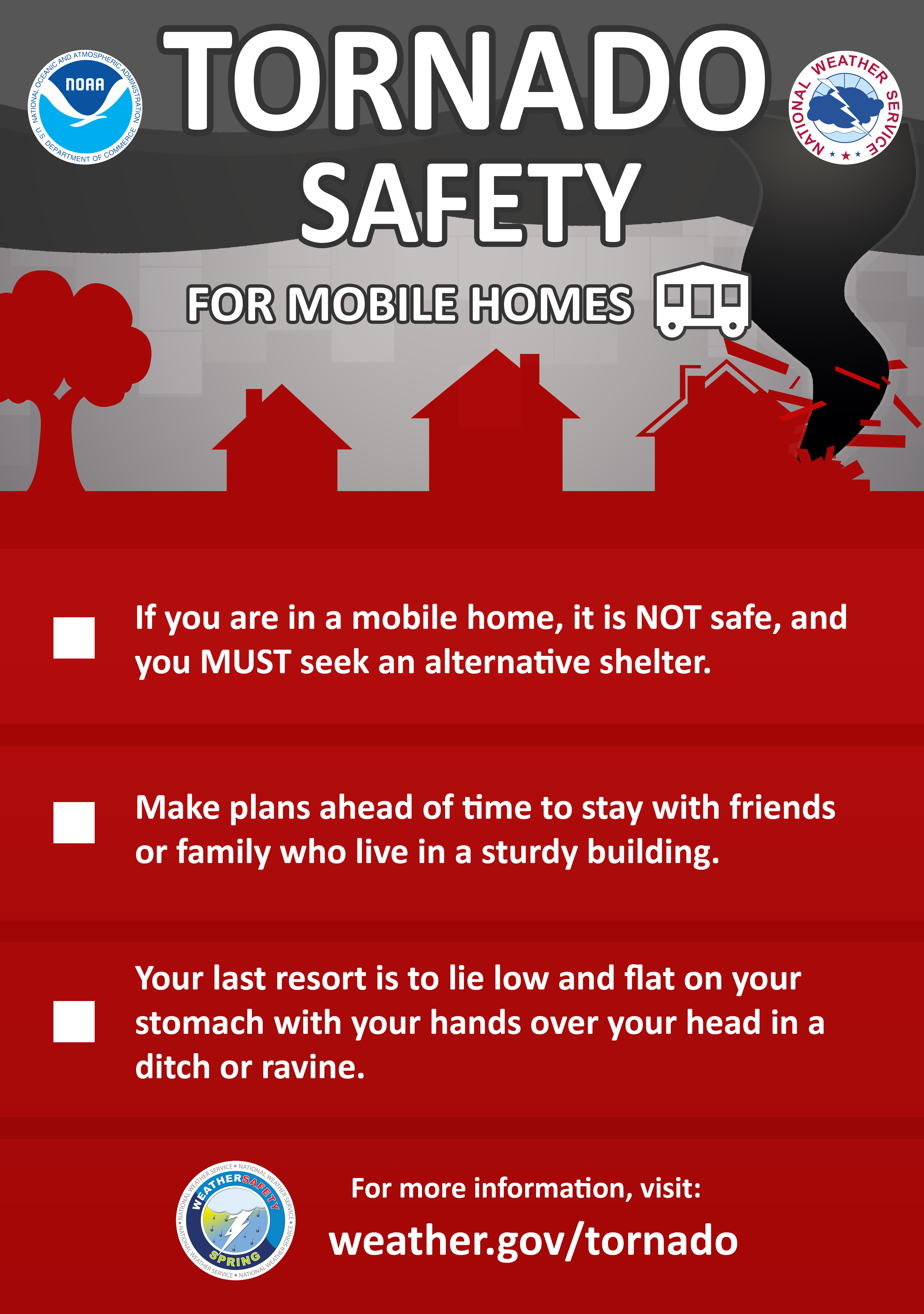
If you are in a mobile home or home on stilts:
Get out and take shelter in a sturdy building or storm shelter. If there is not one nearby, take shelter in the most interior room that has no windows, such as an interior bathroom or closet.
 |
 |
 |
If you are outside with no shelter available, there is no single research-based recommendation for what last-resort action to take, because many factors can affect your decision. Possible actions include:
What to Do After a Tornado
Use the telephone only for emergency calls. Avoid downed power lines and report them to your utility company. Stay out of damaged buildings.
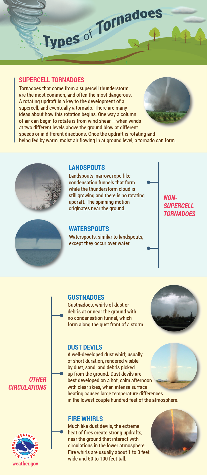
Did You Know There Are Different Types of Tornadoes?
Flooding
FLOODING! Stats and Danger
In South Carolina, several variations of flood hazards occur due to the different effects of severe thunderstorms, hurricanes, seasonal rains and other weather-related conditions. The State's low-lying topography, combined with its humid subtropical climate, makes it highly vulnerable to inland or riverine flooding. Riverine flooding occurs when the flow of rainwater runoff is greater than the carrying capacities of the natural drainage systems. The largest riverine flood in South Carolina, based on the area affected, was the 1903 flood. Relentless rains associated with warm moist air and a low-pressure system caused this flood. The textile communities of Clifton and Pacolet were hardest hit. The Pacolet River rose as much as 40 feet in an hour, resulting in the deaths of sixty-five people.
In comparison to riverine flooding, coastal flooding is usually the result of a severe weather system such as a tropical storm or hurricane, which contains an element of high winds. The damaging effects of coastal floods are caused by a combination of storm surge, wind, rain, erosion and battering by debris. In 1999, three tropical systems resulted in over 24 inches of rain in Horry County. The Waccamaw River and tributaries caused significant flooding throughout northeastern South Carolina. More recently, significant river and coastal flooding occurred with Hurricanes Matthew, Irma, Florence and Michael as well as the October floods of 2015.
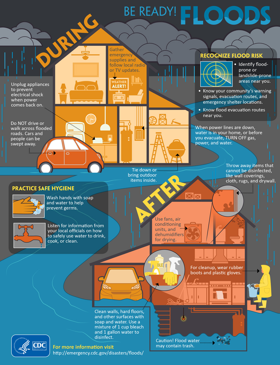
Before a Flood
During a Flood
After a Flood
Flooding Infographics
 |
 |
 |
 |
 |
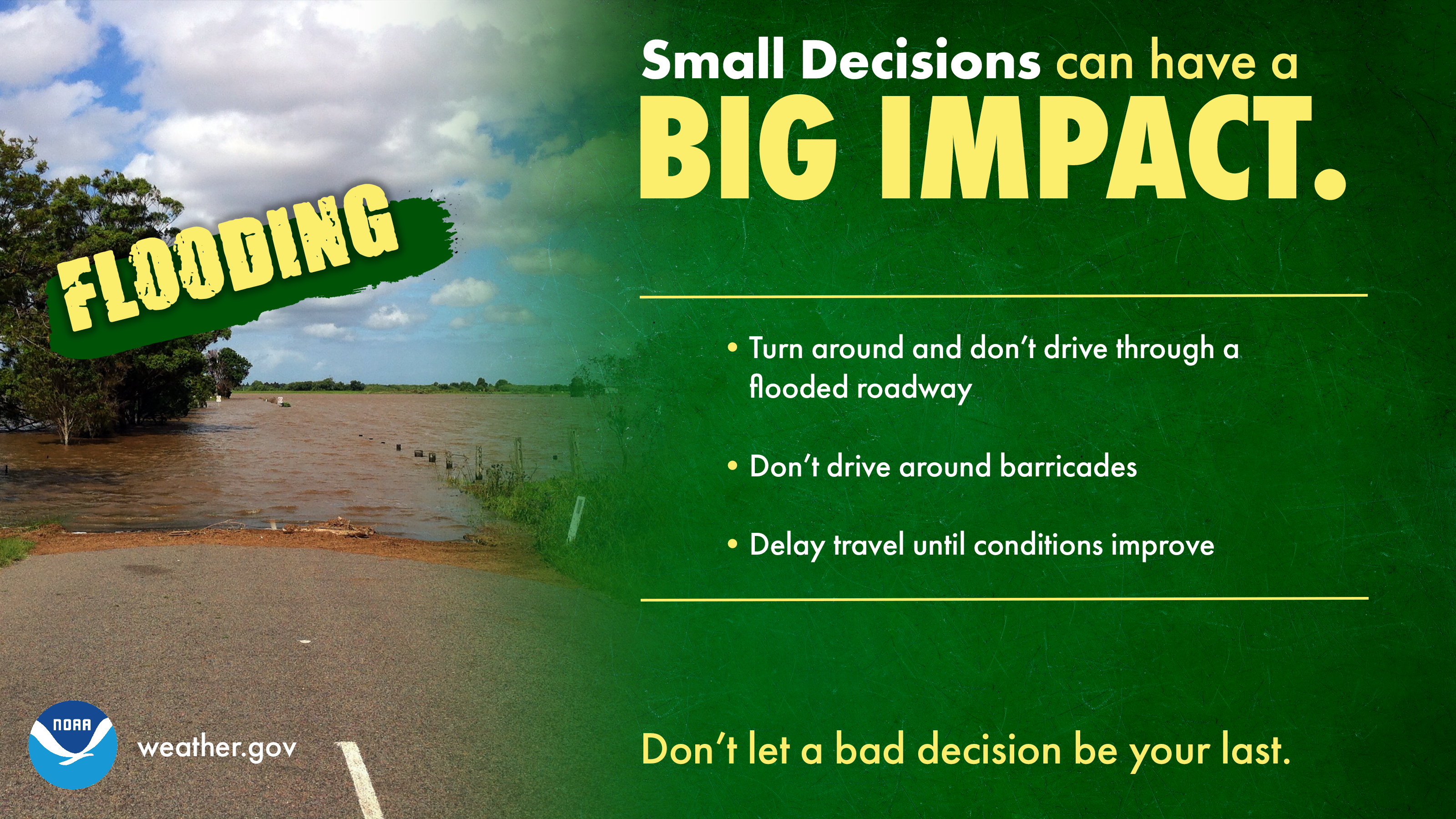 |
Turn Around, Don't Drown
Turn Around, Don't Drown & Flooding Home Safety Tips
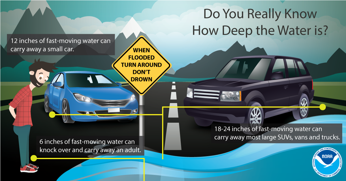
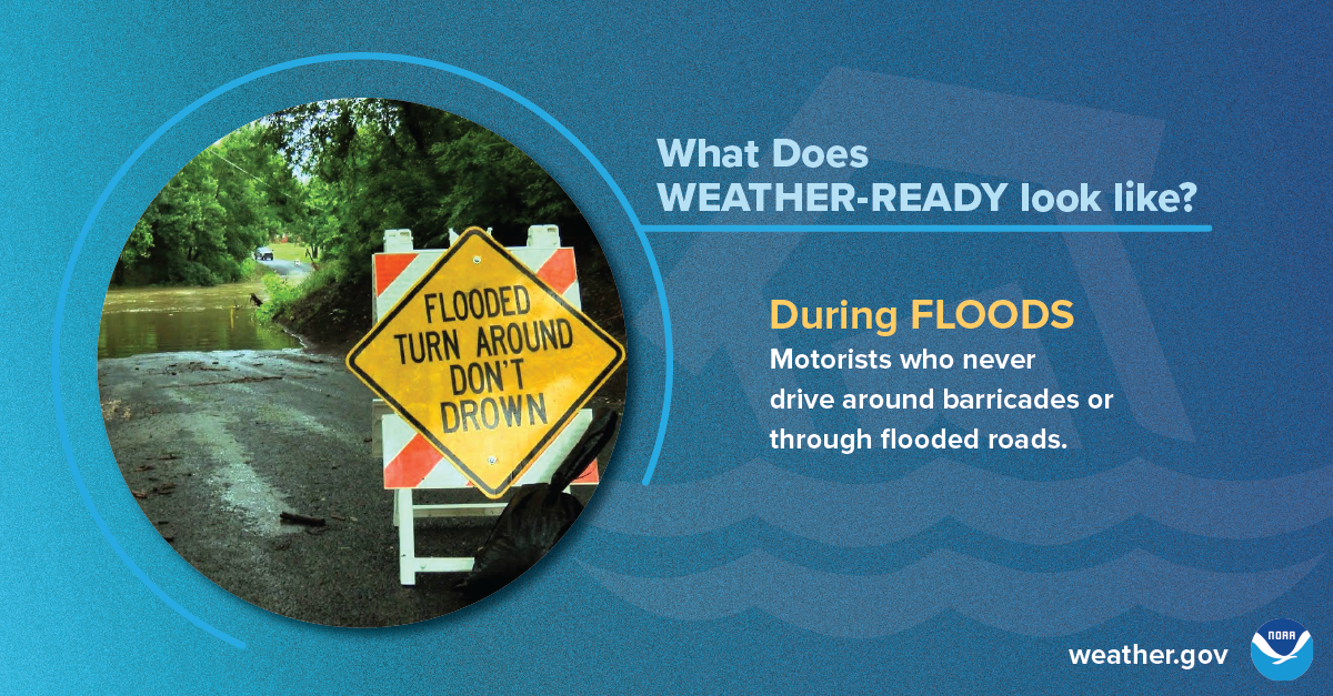
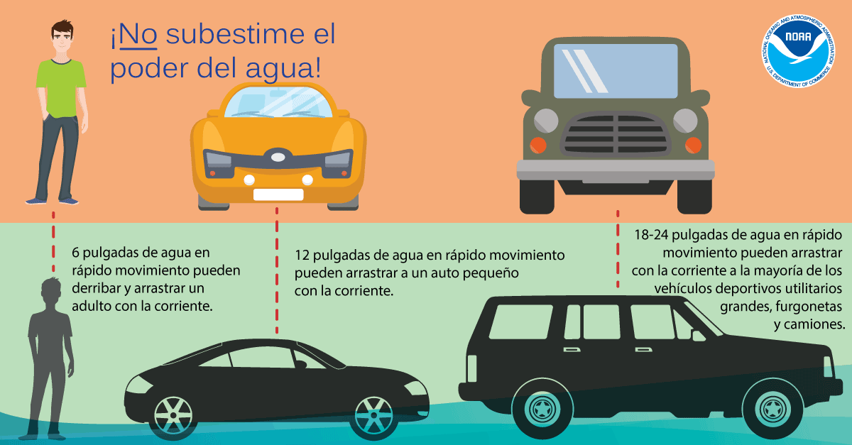
Each year, more deaths occur due to flooding than from any other thunderstorm related hazard. Over half of all flood-related drownings occur when a vehicle is driven into hazardous flood water. The next highest percentage of flood-related deaths is due to walking into or near flood waters. People underestimate the force and power of water. Many of the deaths occur in cars swept downstream. Many of these drownings are preventable. Never drive around the barriers blocking a flooded road. The road may have collapsed under that water. A mere 6 inches of fast-moving flood water can knock over an adult. It takes just 12 inches of rushing water to carry away most cars and just 2 feet of rushing water can carry away SUVs and trucks. It is NEVER safe to drive or walk into flood waters.
Turn Around, Don't Drown Webpage
Flooding Home Safety Tips
Below are a few tips from the American Red Cross on protecting your home from floods:
Visit ready.gov/floods for additional information on preparing for floods.
After the Storm
After the Storm (Storm damage reporting, recovery from storms and flooding, insurance, etc.)
After severe weather hits, stay informed about current weather conditions and forecasts, contact your family and loved ones, assess the damage, and avoid flood waters.
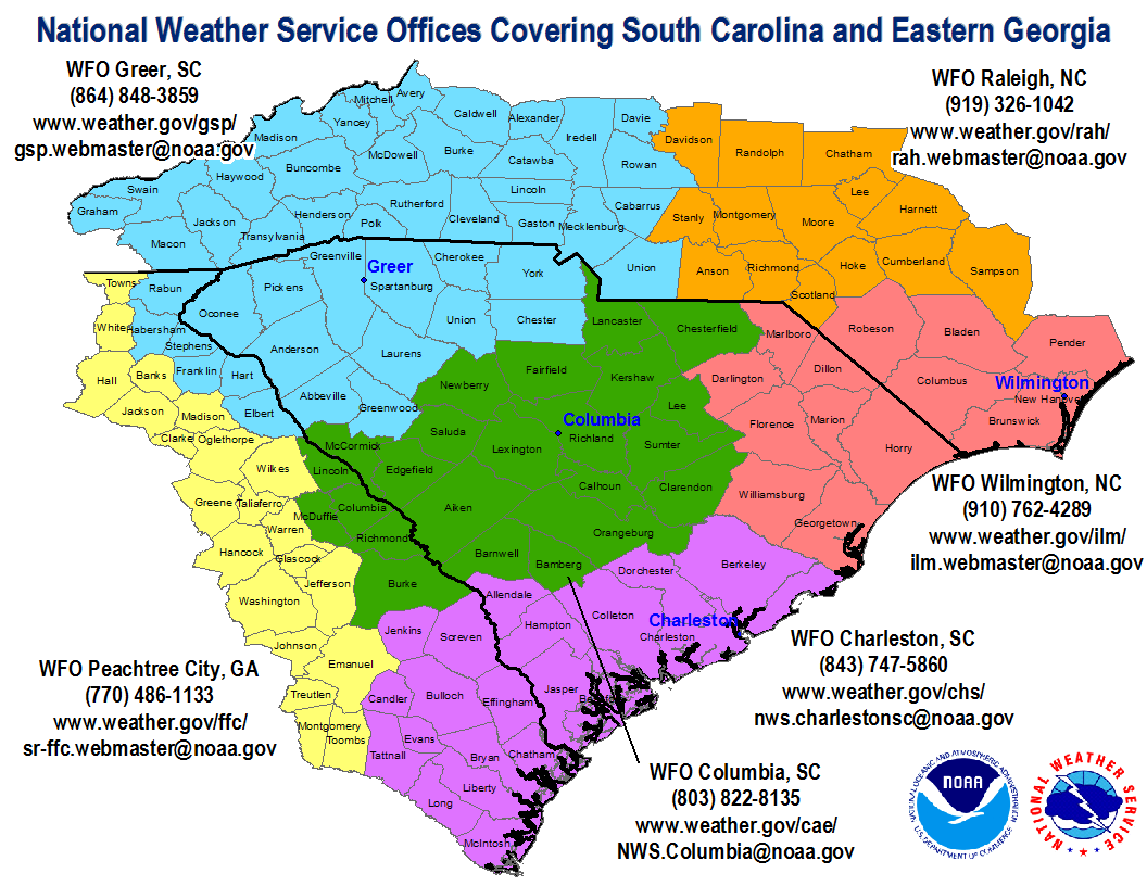
If it is safe to do so, the National Weather Service depends on accurate reporting of severe weather in its mission to protect lives and property. We would like to hear of any significant weather phenomena that you observe, though we are particularly interested in receiving timely reports of tornadoes, one-inch (quarter-sized) and larger hail, damaging wind gusts and flash flooding. Best method of reporting storm reports varies by NWS office, and can be via phone, email, online form, and/or social media. Visit the webpages below for your local SC NWS office to learn more about how to report severe weather:
Greenville-Spartanburg, SC (GSP)
Storm Recovery & Insurance
The South Carolina Emergency Management Division is dedicated to helping individuals and families return to normal and to facilitate the recovery of communities after a storm, from a small storm impacting a local community to a major disaster. The SCEMD coordinates with local, State, and Federal partners, as well as non-governmental organizations and private industries, to ensure that all available resources for individuals and families are provided in a timely and efficient manner. Visit the SCEMD webpage for additional information on storm recovery help for individuals.
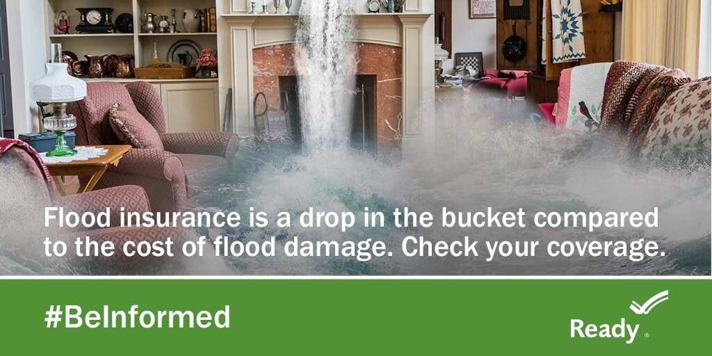
Flood Insurance: The standard homeowner's insurance policy does not include coverage for flood damage, including damage resulting from street flooding, creek overflows or river flooding, or a hurricane's storm surge. If your area is at risk from flooding, you will need to purchase a separate flood insurance policy to protect your home and property from damages due to flood. To learn more about flood insurance, ask your agent and visit www.Floodsmart.gov.
Deaf & Hard of Hearing
#SeeAFlashDashInside
Severe Thunderstorm Safety (ASL Video)
Do you see a lot of strong thunderstorms in your area?
Check out this video in American Sign Language from the National Weather Service
to learn about what you need to know for the next big storm! youtu.be/V-t-9R2o8No
Tornado Safety (ASL Video)
You may only have seconds to get to your safe place when the next tornado occurs!
Learn where to shelter and how to get warning information from the National Weather Service with this video in American Sign Language!
youtu.be/aEPC5F4Zios
See a Flash, Dash Inside (ASL Video)
If you are outdoors and see a flash of lightning or feel the rumble of thunder, dash inside immediately! Check out our Lightning Safety video in American Sign Language and captioned in English!
Flood Safety Video (ASL Video)
Did you know flooding is the leading cause of death due to storms? Learn more about Flood Safety with this video in American Sign Language and captioned in English! youtu.be/RUf3ErtEbG4
NOAA Weather Radio (ASL Video)
NOAA Weather Radios receive warnings, watches, forecasts, and other hazard information 24 hours a day. Why would Deaf people want a radio? They can be used as a way to alert you or wake you up at night! Some come with flashing lights, vibrating alarm attachments, and color displays with text readouts for use by those with hearing loss. youtu.be/A4izxOnKnug
General Safety and Preparedness Tips (ASL Video)
Having a plan is important in times of emergency, and this includes building an emergency preparedness kit before a disaster. Learn how with this video in American Sign Language.
youtu.be/XWEvqy0e9-0
Severe Weather Safety (Español)
Estar listo para los desastres requiere preparación, no la suerte. Conozca su riesgo, haga un plan y tenga un kit. www.listo.gov
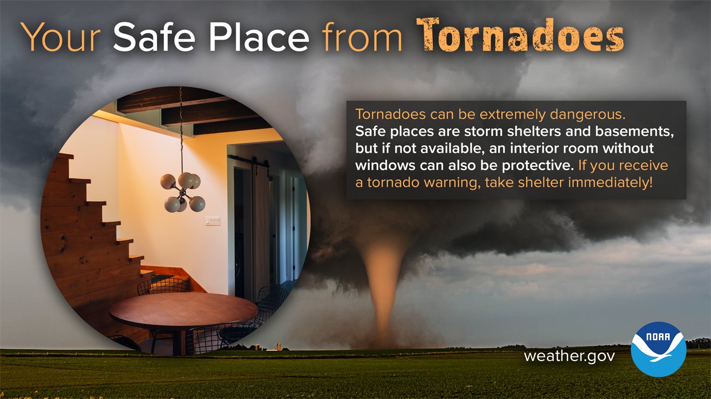
Su Lugar Seguro de Tornados (Your Safe Place from Tornadoes)
Los tornados pueden ser extremadamente peligrosos. Los lugares seguros incluyen refugios para tormentas y sótanos, pero si no están disponibles, una habitación interior sin ventanas también puede protegerle. Si recibe un aviso de tornado, ¡busque refugio de inmediato! weather.gov/safety/tornado

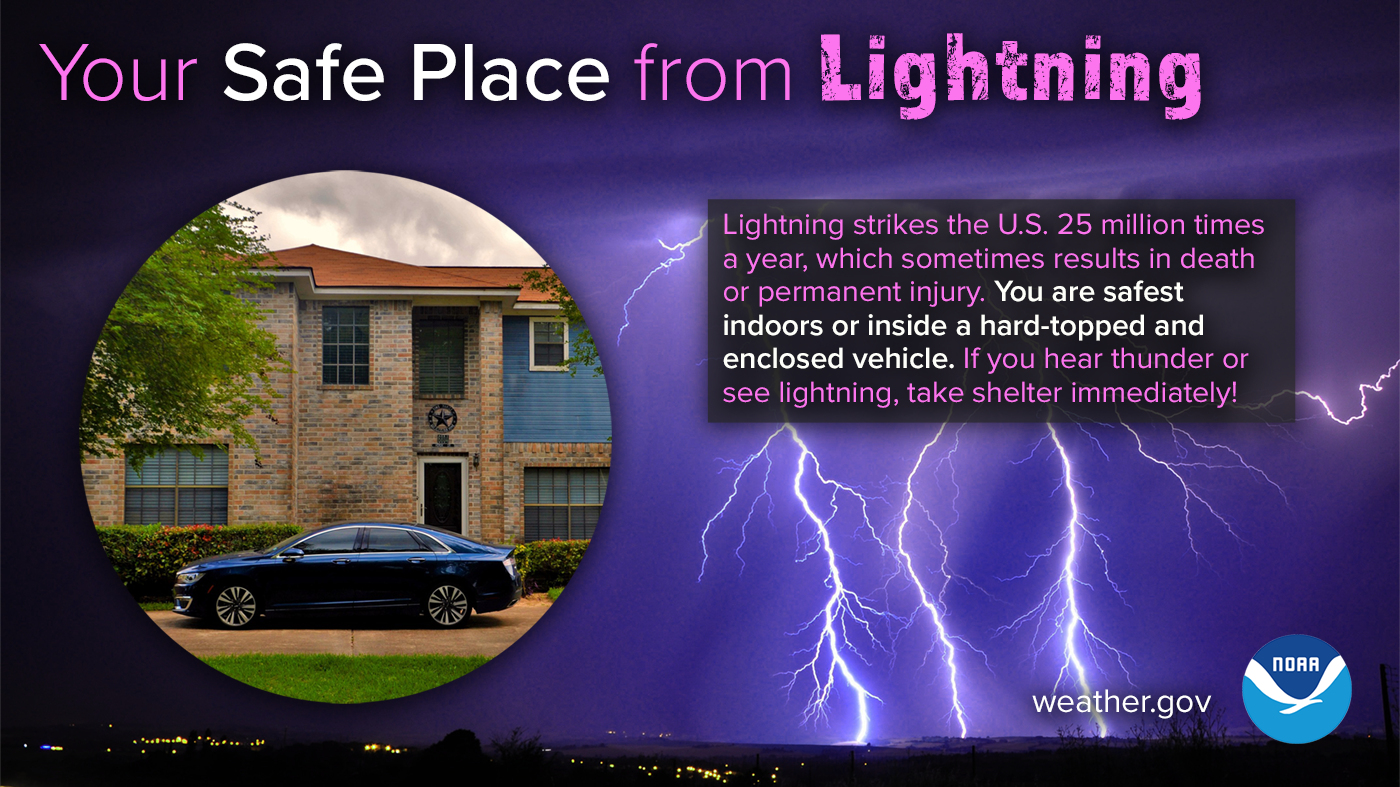
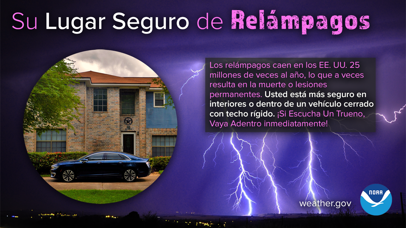
Su Lugar Seguro de Relámpagos (Your Safe Place from Lightning)
Los relámpagos caen en los EE. UU. 25 millones de veces al año, lo que a veces resulta en la muerte o lesiones permanentes. Usted está más seguro en interiores o dentro de un vehículo cerrado con techo rígido. Manténgase preparado para las condiciones del tiempo y obtenga más información sobre la seguridad contra relámpagos: weather.gov/safety/lightning
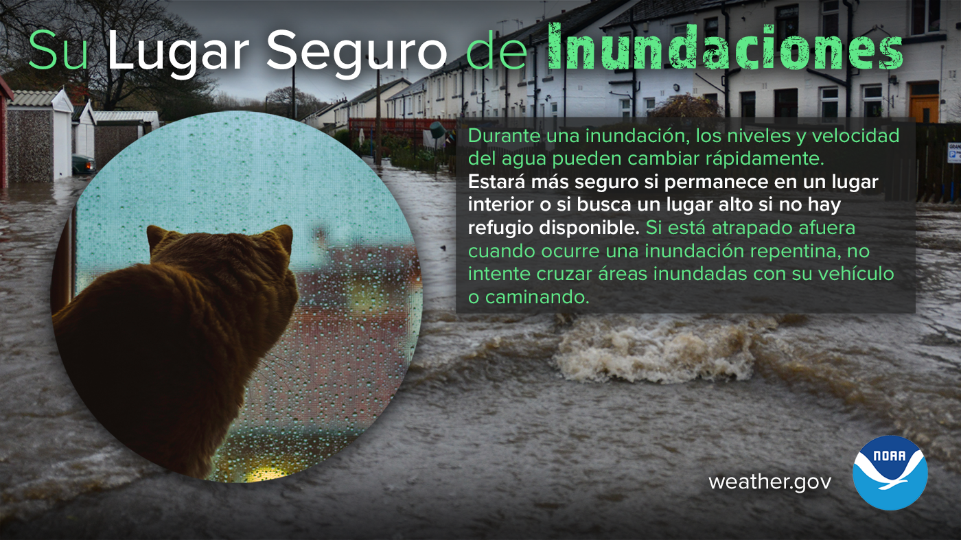
Su Lugar Seguro de Inundaciones (Your Safe Place from Flooding)
Durante una inundación, los niveles y velocidad del agua pueden cambiar rápidamente. Estará más seguro si permanece en un lugar interior o si busca un lugar alto si no hay refugio disponible. Si está atrapado afuera cuando ocurre una inundación repentina, no intente cruzar áreas inundadas con su vehículo o caminando. Obtenga más información sobre la seguridad contra inundaciones en weather.gov/safety/flood
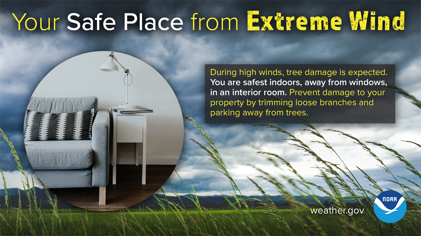
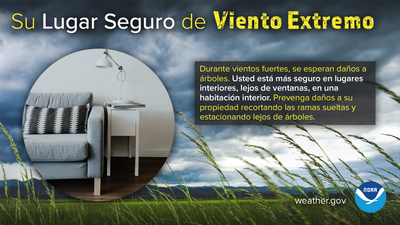
Su Lugar Seguro de Viento Extremo (Your Safe Place from Extreme Wind)
Durante vientos fuertes, se esperan daños a árboles y los objetos sueltos podrían volar por el aire y ser peligrosos. Usted está más seguro en lugares interiores, lejos de ventanas, en una habitación interior. Manténgase preparado para las condiciones del tiempo y obtenga más información sobre la seguridad de vientos fuertes: weather.gov/safety/wind
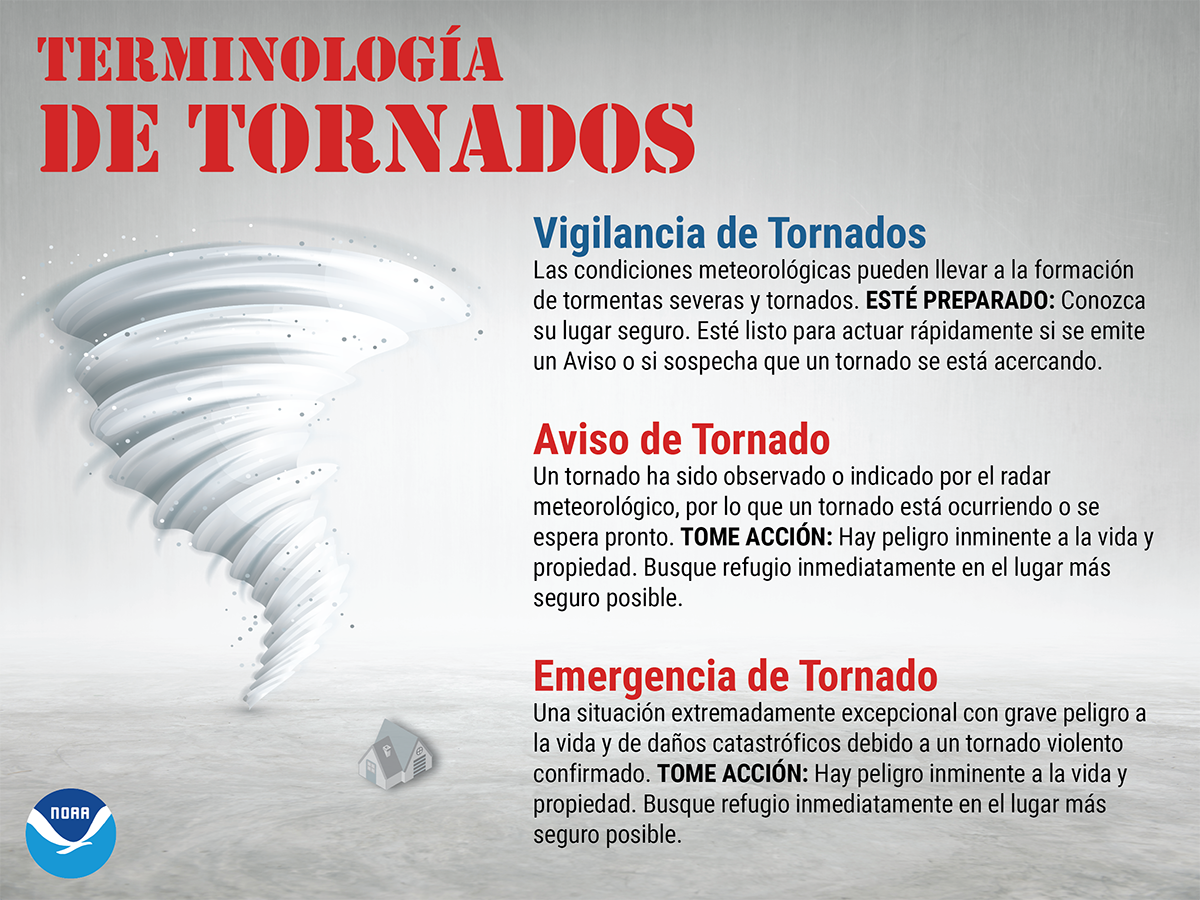
Terminología De Tornados (Tornado Terminology)
Una VIGILANCIA de tornados significa ESTÉ PREPARADO. Un AVISO o una EMERGENCIA de tornado significa TOME ACCIÓN.
En caso de una vigilancia de tornados, preste mucha atención al tiempo y esté listo para actuar, porque existe la posibilidad de tornados. En caso de un aviso de tornado, busque refugio inmediatamente, y diríjase a una habitación interior en la planta más baja de un edificio seguro, porque un tornado está ocurriendo u ocurrirá pronto. Evite las ventanas y cúbrase la cabeza para protegerse de los escombros lanzados por el tornado. ¡Tomar acción de antemano puede ayudar a salvar vidas! weather.gov/safety/tornado-ww
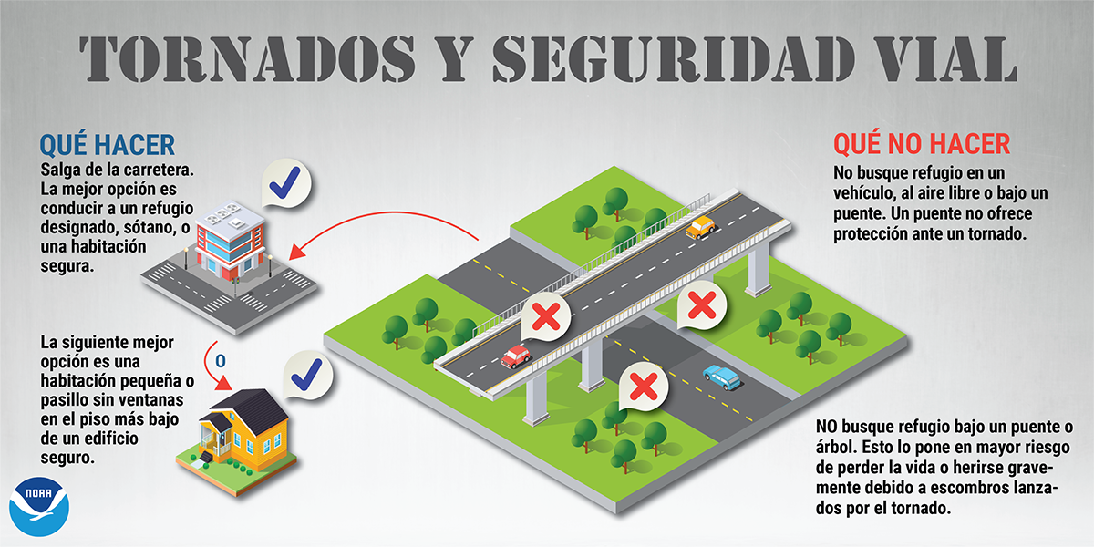
Terminologa De Tornados (Tornadoes and Road Safety)
Durante un tornado, buscar refugio en un vehículo o bajo un puente NO es seguro. Si está al aire libre durante un aviso de tornado, la mejor opción es conducir a un refugio designado, sótano o una habitación segura. weather.gov/safety/tornado #SpringSafety
Vigilancia vs Aviso de Tormentas Severas (Thunderstorm Watch vs. Warning)
Una VIGILANCIA de tormentas severas significa ESTÉ PREPARADO. ¡Un AVISO de tormenta severa significa TOME ACCIÓN! Si hay una vigilancia de tormentas severas en efecto, manténgase informado y esté listo para actuar, porque tormentas severas son posibles. En caso de un aviso de tormenta severa, refúgiese en un edificio seguro. Tiempo severo está ocurriendo u ocurrirá en breve. weather.gov/safety/thunderstorm-ww

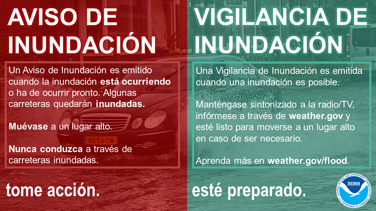
Aviso vs Vigilancia de Inundaciones (Flood Warning vs. Watch)
Un AVISO de inundación significa TOMAR ACCIÓN. Una VIGILANCIA de inundación significa PREPARARSE. Cuando se emite un Aviso, significa que inundaciones son inminentes o que ya están ocurriendo. Cuando una Vigilancia de Inundación está en efecto, significa que es posible que ocurra una inundación en su área. weather.gov/safety/flood-watch-warning #FloodSafety
Graifica - El Ponder del Agua (Infographic - Power of Water)
No subestime el poder del agua. Sólo se necesitan 6 pulgadas de agua en rápido movimiento para derribar y arrastrar a un adulto, y 12 pulgadas de agua para arrastrar a un automóvil pequeño. ¡Dé la Vuelta, No Se Ahogue! weather.gov/safety/flood-turn-around-dont-drown
Local SC Severe Events
Find us on social media:
You can also contact:
Brandon Locklear (Clyde.Locklear@noaa.gov) for additional information about Severe Weather Preparedness.


 X
X Facebook
 YouTube
 Coastal Flood