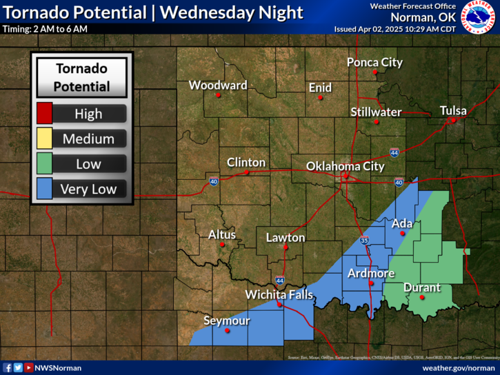
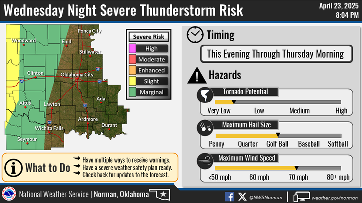
National Weather Service United States Department of Commerce

Heavy Rain and Flash Flooding Threat in Montana; Severe Thunderstorms in the Middle Missouri Valley

A low pressure system will bring heavy to excessive rainfall and high winds across Montana this afternoon. Heavy rainfall totals may lead to scattered flash flooding concerns. A line of showers and strong to severe thunderstorms will move into the mid Missouri Valley region this afternoon producing severe winds and isolated large hail with stronger storms. Read More >

Click a location below for detailed forecast.

Last Map Update: Wed, Sep 18, 2024 at 6:24:51 pm CDT

A few thunderstorms are possible across western into northern Oklahoma Wednesday evening. A few strong to severe storms will be possible, with damaging wind gusts the main hazard.
Scattered thunderstorms are possible this afternoon and evening across northwest and into far western Oklahoma. There is a marginal risk that storms could become severe, with cloud-to-ground lightning and strong wind gusts up to 60 mph the main hazards of concern.
Strong to severe storms appear possible Thursday afternoon and evening near a weak surface front. Damaging wind gusts will be the main threat from these storms, along with cloud-to-ground lightning.

 Current Weather Observations...
Location Time
(CDT)
Weather Vsby.
(SM)
Temp.
(ºF)
Dewpt.
(ºF)
Hum.
(%)
Wind
(mph)
Wind Chill / Heat Index
(ºF)
Pres.
(in)
Oklahoma City, OK17:52Partly Cloudy10926642SSE 14G2395 [HI]29.80
Norman, OK17:45Partly Cloudy10916643ESE 1694 [HI]29.79
Stillwater, OK17:53Mostly Cloudy10966637SSE 14G24100 [HI]29.78
Lawton, OK17:53Clear10976231SSE 17G2898 [HI]29.77
Wichita Falls, TX17:52Clear10966333SSE 21G2998 [HI]29.77
Ponca City, OK17:53Clear10936641S 10G2896 [HI]29.77
Enid, OK17:55Clear10956334SSE 2297 [HI]29.73
Alva, OK17:55Clear10965928S 22G2996 [HI]29.72
Woodward, OK17:55Partly Cloudy10915933S 21G28-29.78
Gage, OK17:53Clear10966232S 20G3597 [HI]29.74
Watonga, OK17:55Clear10946133S 18G2695 [HI]29.80
Clinton, OK17:53Clear10945931S 23G3293 [HI]29.78
Weatherford, OK17:55Clear10965828S 17G2495 [HI]29.78
Altus, OK17:55Clear10966232S 16G2597 [HI]29.75
Frederick, OK17:53Clear10985927SSE 23G3198 [HI]29.74
Ardmore, OK17:50Clear10936438SSE 1495 [HI]29.80
Ada, OK17:55Partly Cloudy10936843SE 13G1797 [HI]29.83

Local Weather History For September 18th...
Two people were injured just west of Weatherford on September 18,
1978, when severe thunderstorm winds demolished the mobile home they
were in. One required hospitalization. Winds were estimated at around
60 mph.

Text Product Selector (Selected product opens in current window)
Weather Observations Area Forecast Discussion Air Quality Forecasts Hydrology Information Frequently Asked Questions Social Media
Observations Discussion Air Quality Hydrology FAQ Social Media
 
Submit a Storm Report Graphical Weather Forecasts Aviation Weather Forecasts Climate Data Storm Data Weather Radio Information
Storm Reports Gridded Forecast Aviation Climate Storm Data Weather Radio  
 
Satellite Information Hourly Weather Forecast Fire Weather Information Past Weather Events StormReady Skywarn/Storm Spotters
Satellite Hourly Forecast Fire Weather Past Events StormReady Storm Spotters