
Heat expands across the Desert Southwest, Plains, Mississippi Valley and Midwest into Monday. Fire weather concerns continue for portions of the Intermountain West. Active monsoonal moisture fuels thunderstorms over the Southwest with possible flash flooding. Tropical cyclone Fausto in the Pacific, should weaken as it approaches Hawaii; Dangerous surf, swells and rip currents are expected. Read More >
Overview
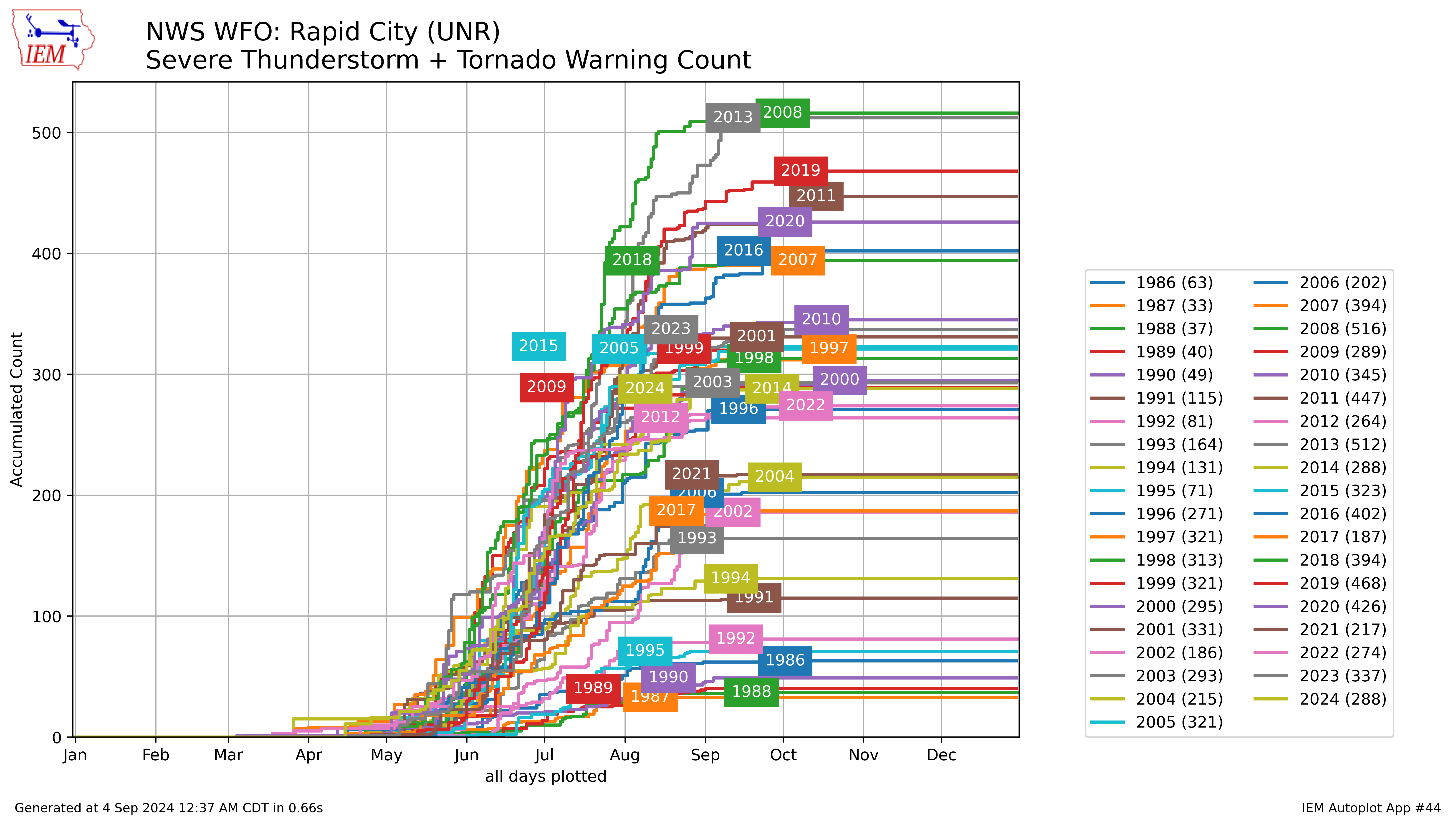 |
| Total Severe Thunderstorm and Tornado Warning count by year for our county warning area, since 1996. Credit Daryl Herzmann at the Iowa Environmental Mesonet (https://mesonet.agron.iastate.edu/). |
|
Severe weather season across western South Dakota and northeastern Wyoming is relatively short compared to much of the Plains and eastern U.S. but also relatively active. Typically, the Rapid City weather forecast office issues around 300 Severe Thunderstorm and Tornado Warnings per year (shown at left), with the majority coming from late May through August. As a result, during most years, we are among the top ten offices in terms of warnings issued. In 2020, our count of 426 was fifth in the country. This climatology page will provide a look at our typical annual and diurnal cycles of Severe Thunderstorm and Tornado Warnings and their associated hazards: large hail, damaging straight-line winds, and, of course, tornadoes. Many of the images herein are courtesy of Daryl Herzmann at the Iowa Environmental Mesonet, while data for the climatology was provided by the Storm Prediction Center and, specifically, Andy Dean. If you have any questions or suggestions for additions, please email those to our meteorologist maintaining this page, Keith Sherburn. |
Tornadoes
Updated 9/3/2024
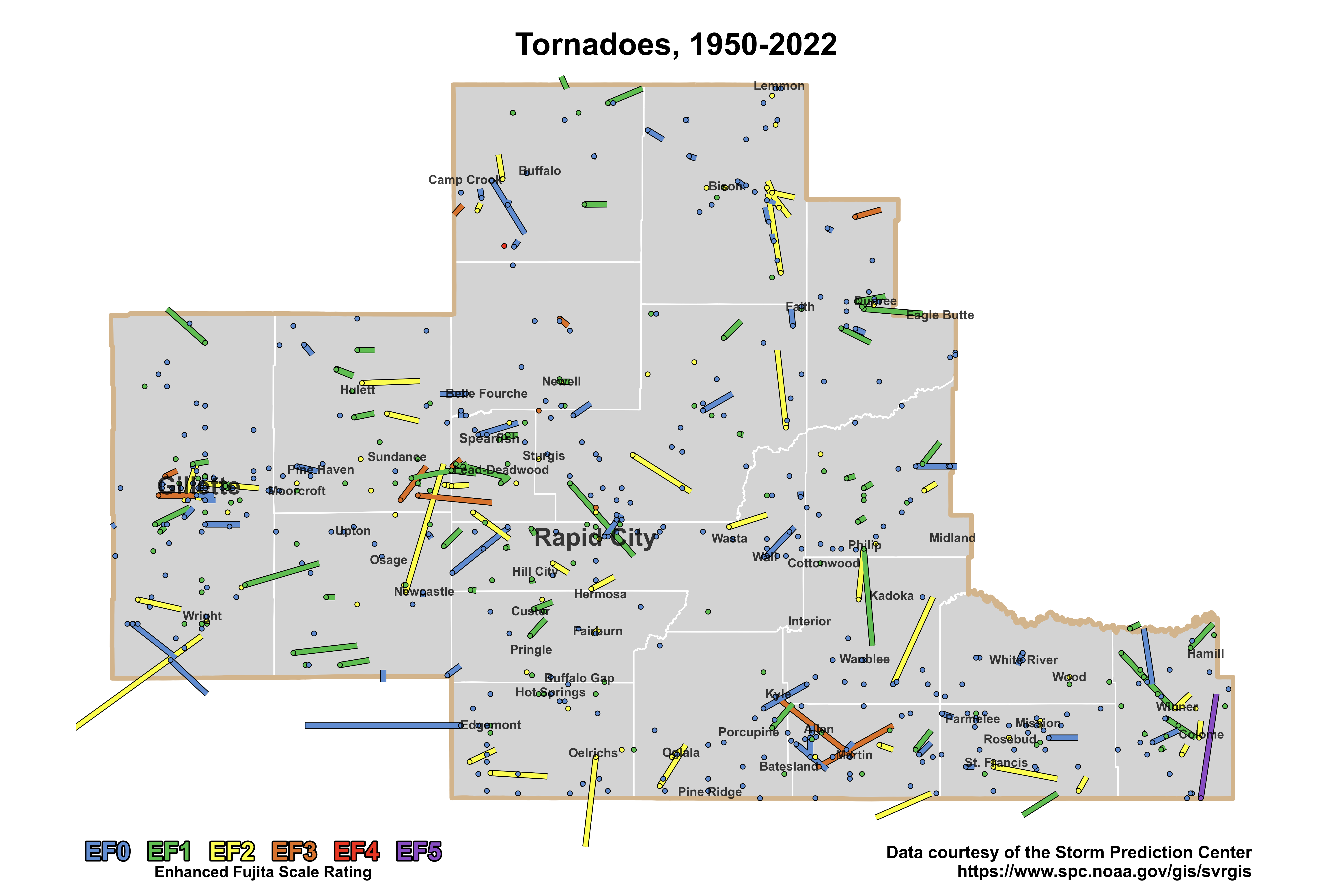
With the potential to produce winds over 200 miles per hour (mph), tornadoes are potentially the most devastating severe weather phenomenon across the central United States. Though not as frequent as large hail or damaging straight-line winds across western South Dakota and northeastern Wyoming, tornadoes are still common for our area, with about seven occurring each year on average.
 |
|
Map of all official tornado tracks for our area of responsibility from 1950 to 2023. |
The enhanced Fujita (EF) scale is used to classify tornadoes and does so using the following categories:
| EF0 Weak 65-85 mph |
EF1 Moderate 86-110 mph |
EF2 Significant 111-135 mph |
EF3 Severe 136-165 mph |
EF4 Extreme 166-200 mph |
EF5 Catastrophic 200+ mph |
 |
|||||
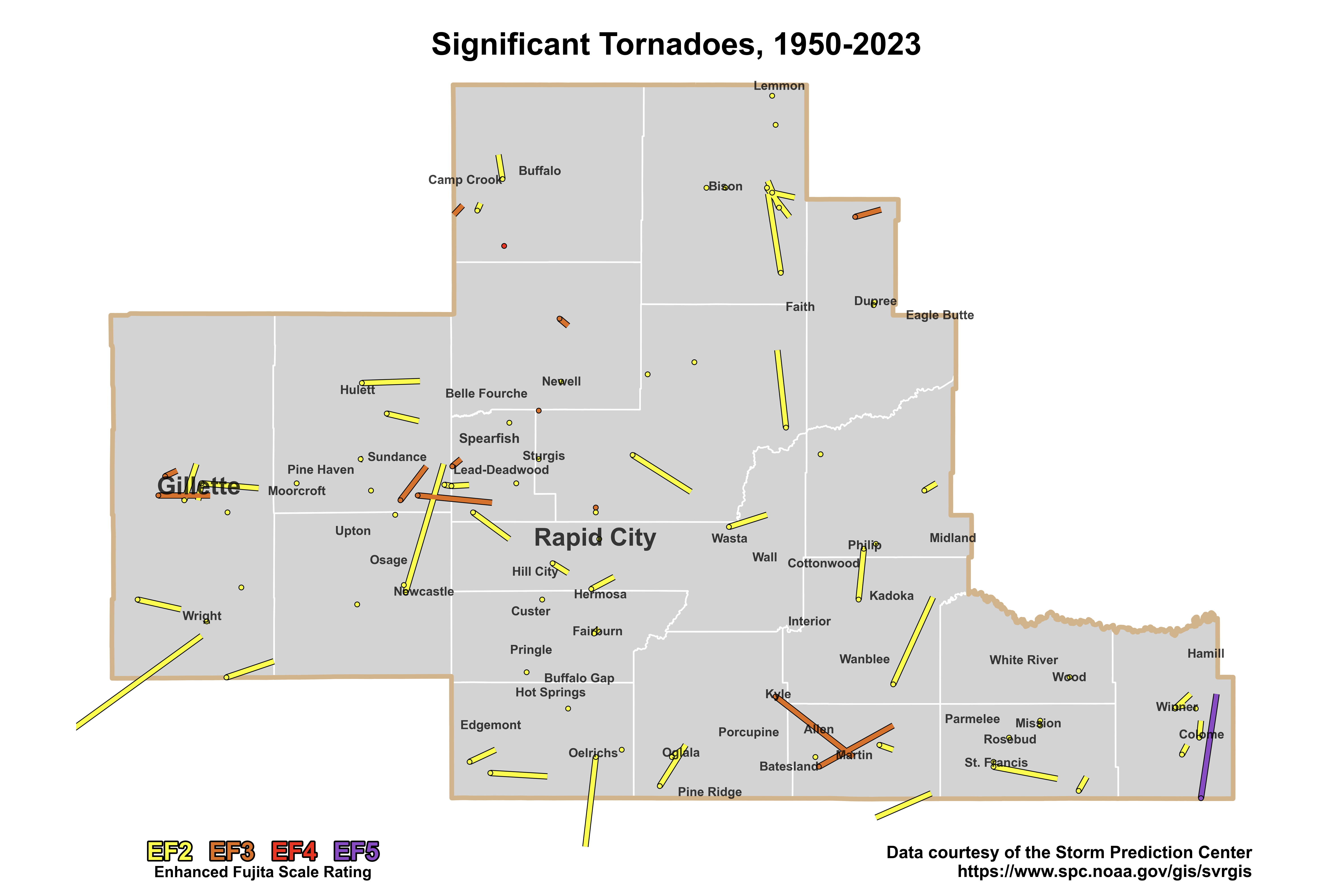
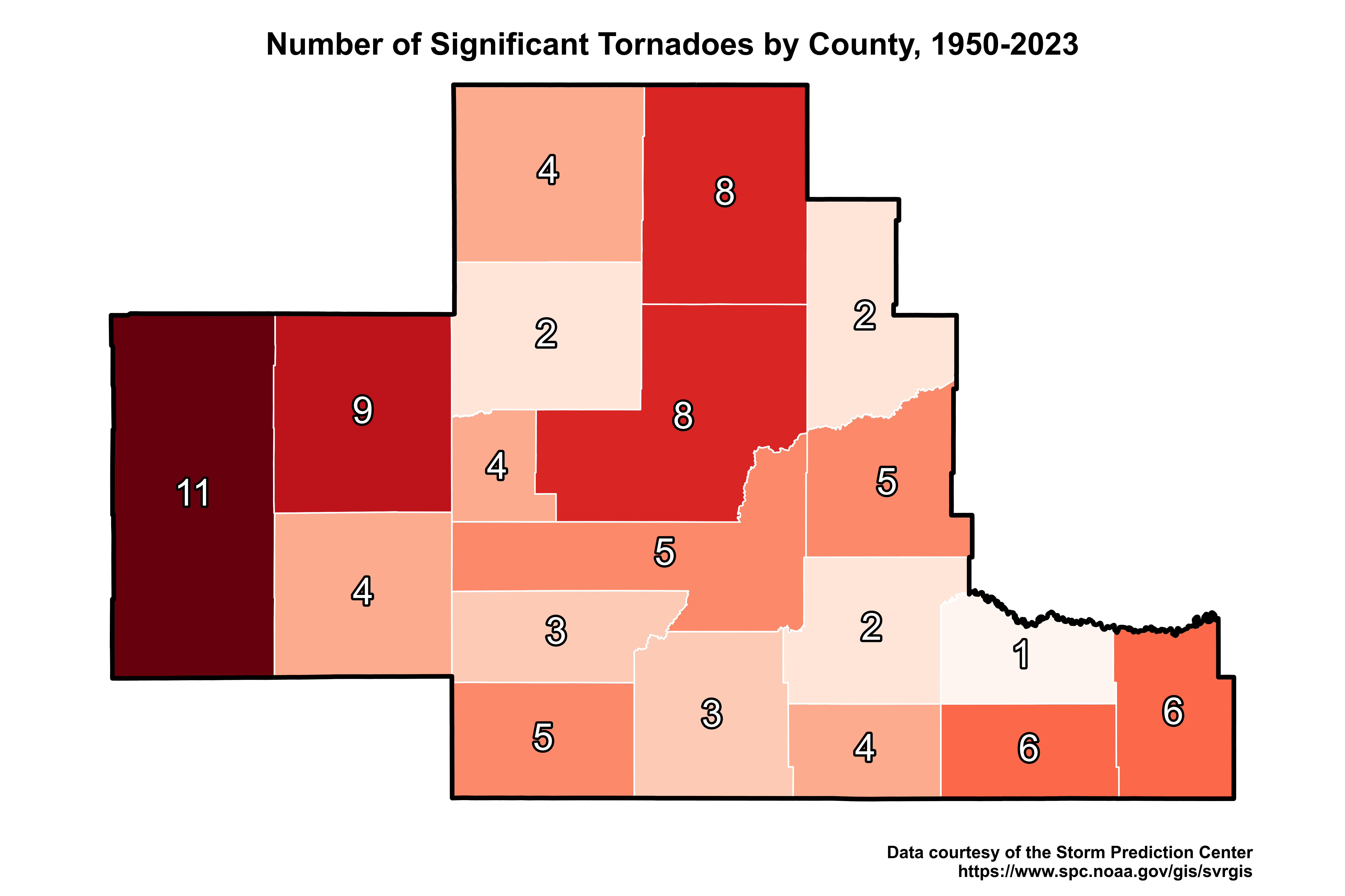
Though the majority of tornadoes are rated EF0 and EF1, we've also experienced many "significant" tornadoes, which are those rated EF2 or higher. These are considered significant because of their increased impact on life and property.
 |
|
Map of all significant tornado tracks for our area of responsibility from 1950 to 2023. |
Our area has experienced only one "catastrophic" F5 tornado, which occurred in Tripp County in 1965. You can read more about this event here.
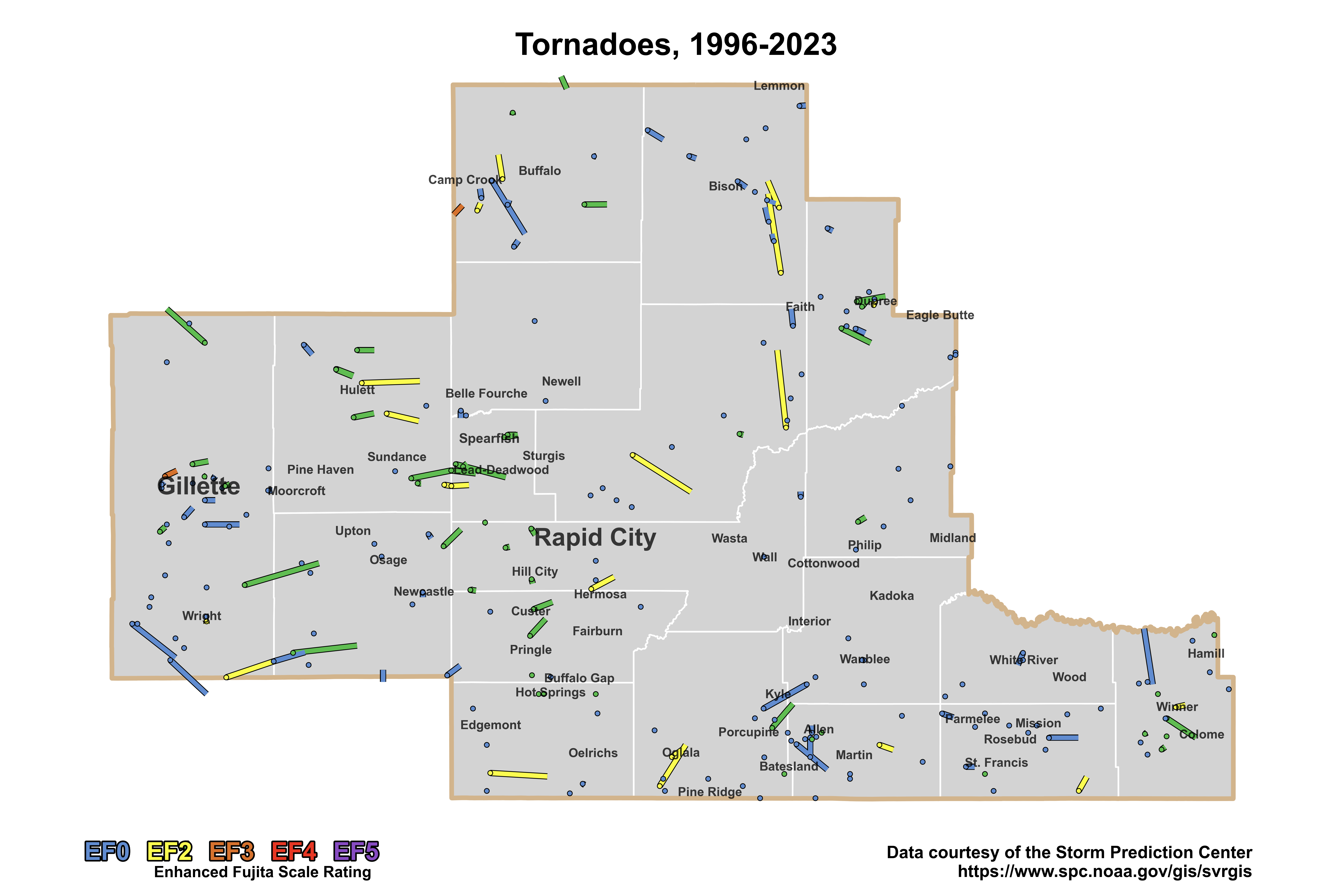
There is some uncertainty in tornado tracks in early decades of the dataset, particularly for weak tornadoes. Tornado records after the nationwide installation of the Weather Surveillance Radar, 1988, Doppler (WSR-88D) network in the early to mid 90s are generally thought to be more accurate. As a result, it is also instructive to look at tornadoes from 1996 onward, when the WSR-88D network became operational. This subset is shown below.
 |
|
Map of all official tornado tracks for our area of responsibility from 1996 to 2023. |
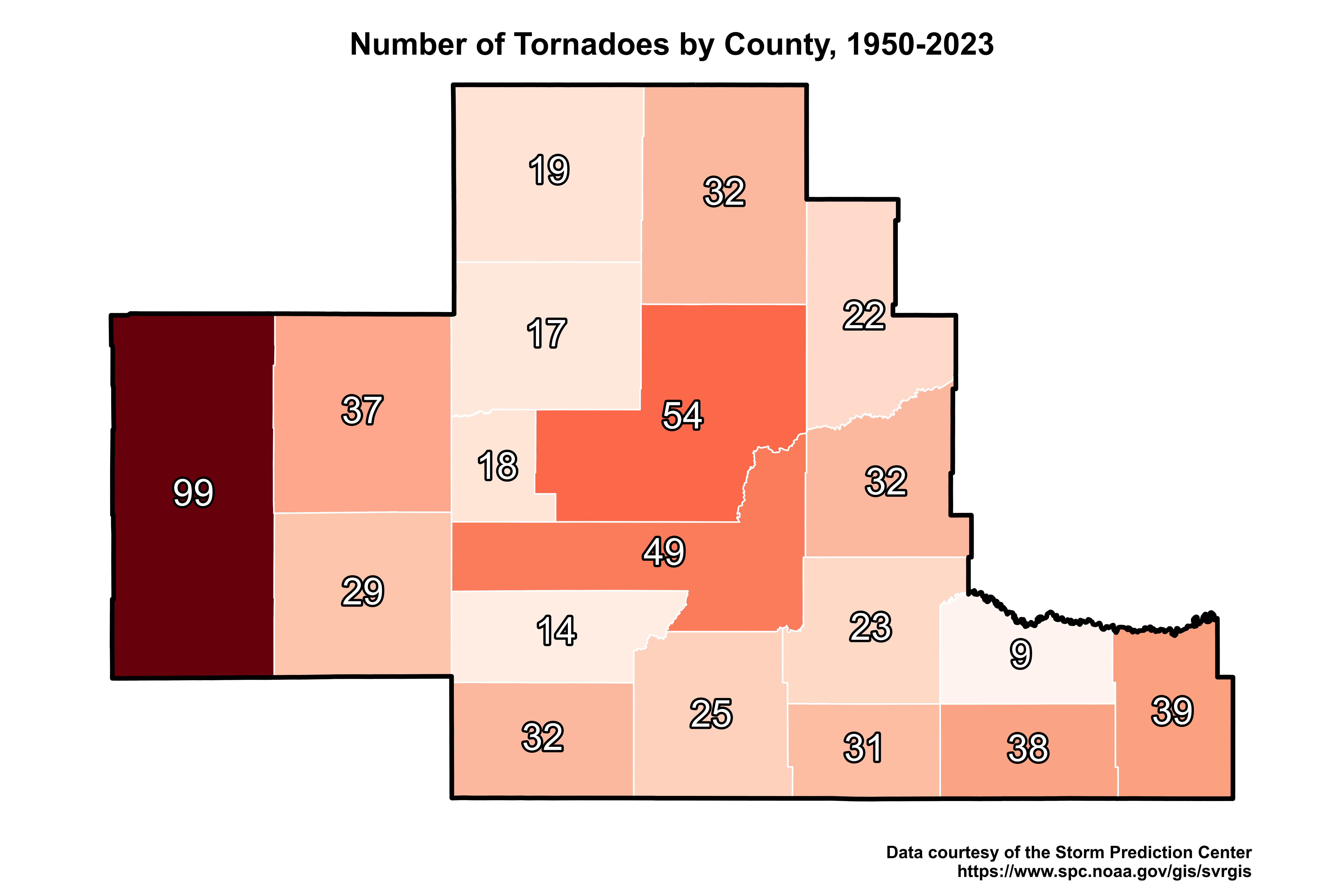
Though tornadoes can and do occur across all of our area, they are most common across the northeastern Wyoming plains and east of the Black Hills, as shown below. This includes significant tornadoes, and it is generally true for the entire official tornado database and the subset from 1996 to present.
 |
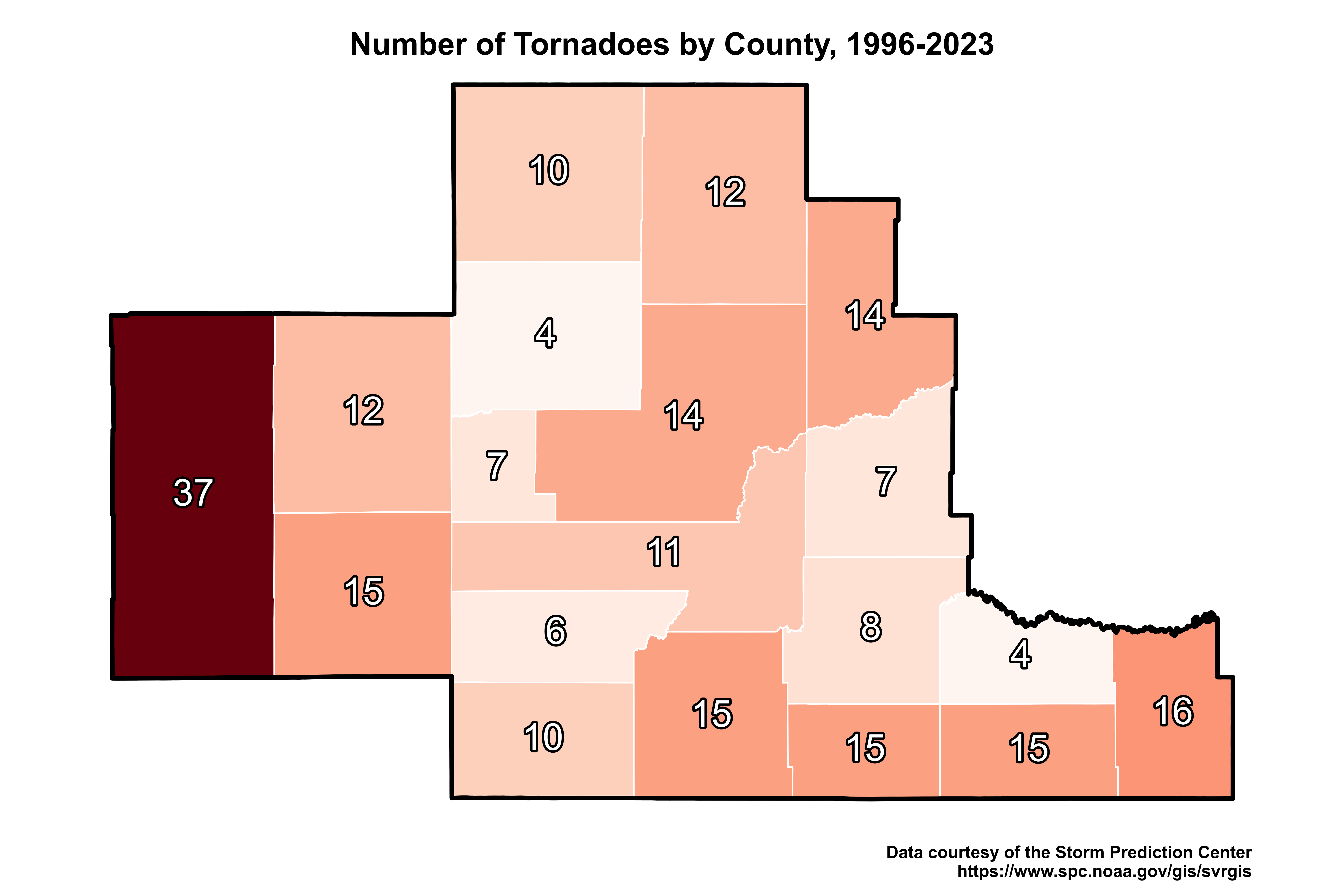 |
| Number of tornadoes per county from 1950 to 2023. | Number of tornadoes per county from 1996 to 2023. |
 |
|
Number of significant tornadoes per county from 1950 to 2023. |
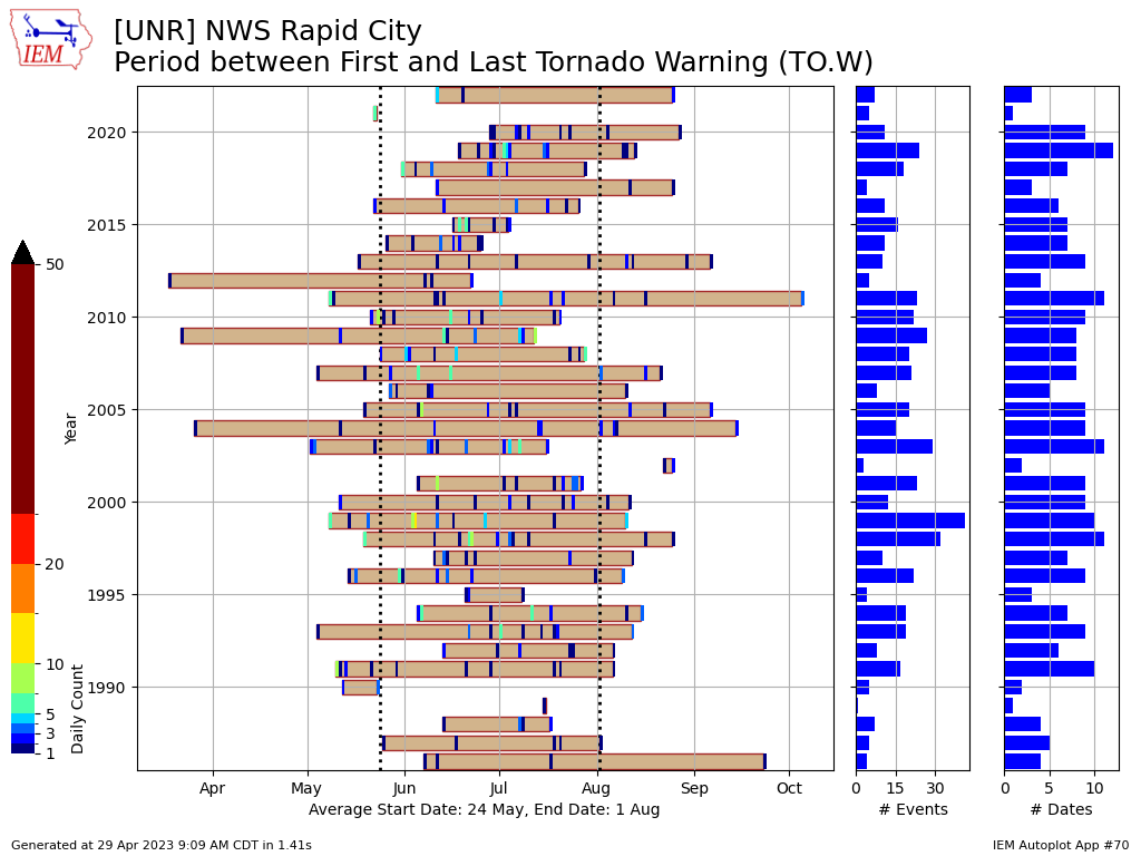
Typically, environments supportive of tornadoes are most common from late spring through the middle of summer, as reflected (below) in the annual cycle of Tornado Warnings for our county warning area. However, we can and do occasionally get tornadoes as early as March and as late as October.
 |
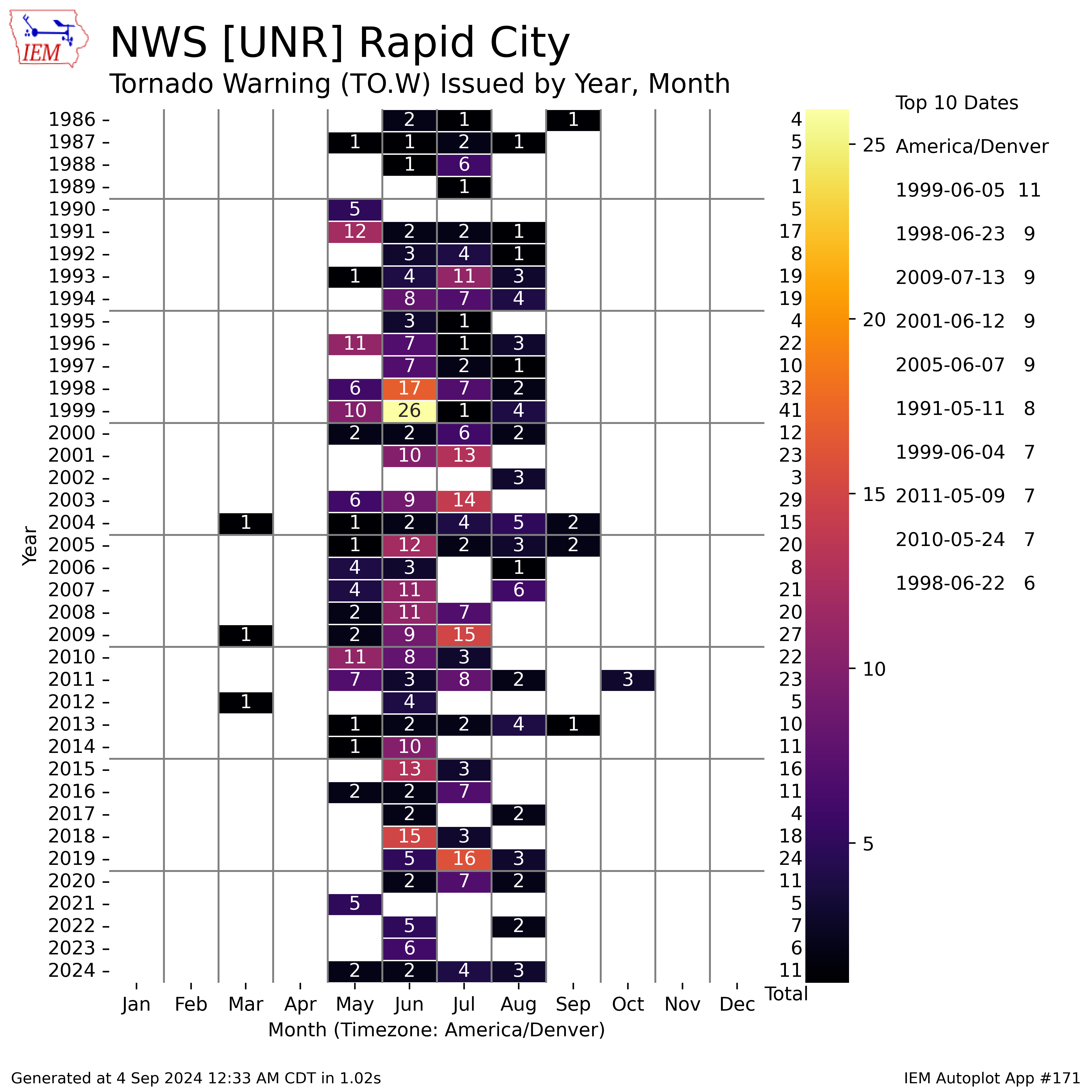 |
| Period extending from first to last tornado warning issued by our office, by year, since 1986. Credit Daryl Herzmann at the Iowa Environmental Mesonet (https://mesonet.agron.iastate.edu/). Note that because our office's county warning area expanded in 1996, you may note an associated change in our warning statistics. | Tornado warnings issued by our office per month, by year, since 1986. Credit Daryl Herzmann at the Iowa Environmental Mesonet (https://mesonet.agron.iastate.edu/). Note that because our office's county warning area expanded in 1996, you may note an associated change in our warning statistics. |
How do the tornado warning counts in each month every year compare to our averages? Compare the image on the right above to the table below, which shows the average number of tornado warnings for a given month between 1986 and 2022.
Average Number of Tornado Warnings per Month (1986-2024)
| Month | March | April | May | June | July | August | September | October | Annual |
|
Average # |
0.1 | 0 | 2.5 | 5.9 | 4.1 | 1.5 | 0.2 | 0.1 | 14.3 |
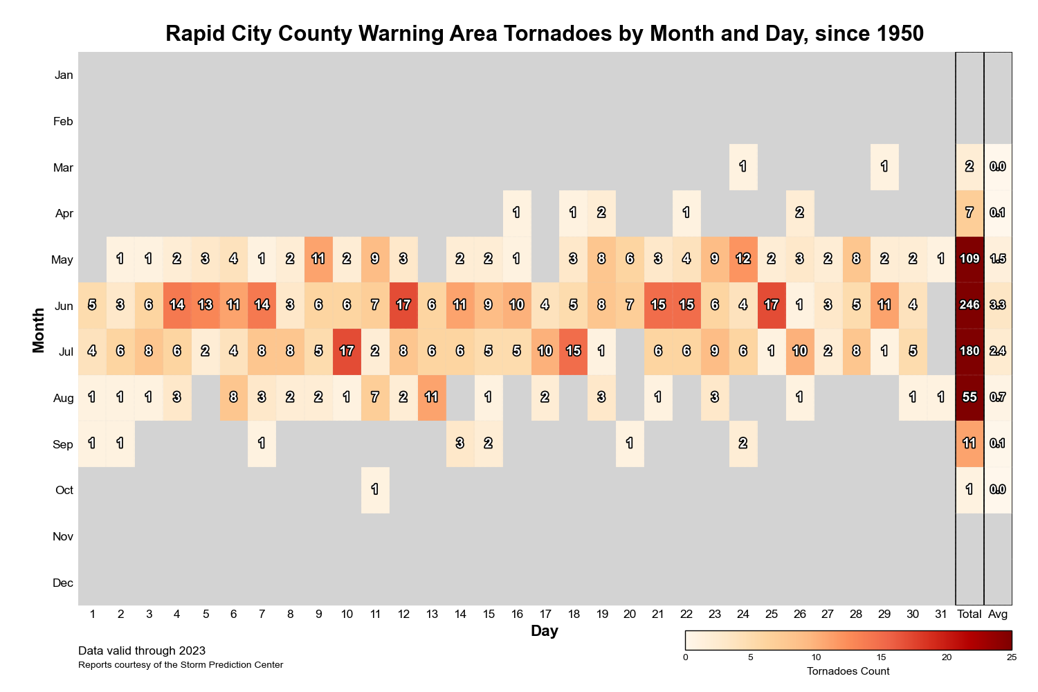
Of course, not every tornado warning has a tornado associated with it, and some warnings include more than one tornado. Here are how the actual tornado counts for our area compare.
 |
|
Number of tornadoes for our area by month and day from 1950 to 2023, including monthly totals and averages. |
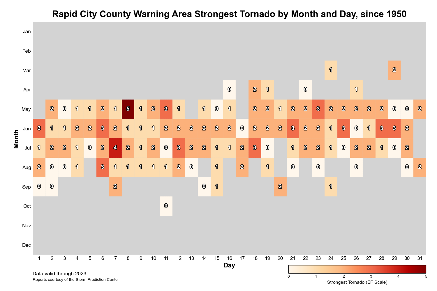
Tornadoes (and significant tornadoes) have occurred within our area in each month from March to September, as shown below, and on most days in the months of May, June, and July.
 |
|
Strongest tornado (by Fujita or enhanced Fujita scale rating) for our area by month and day from 1950 to 2023. |
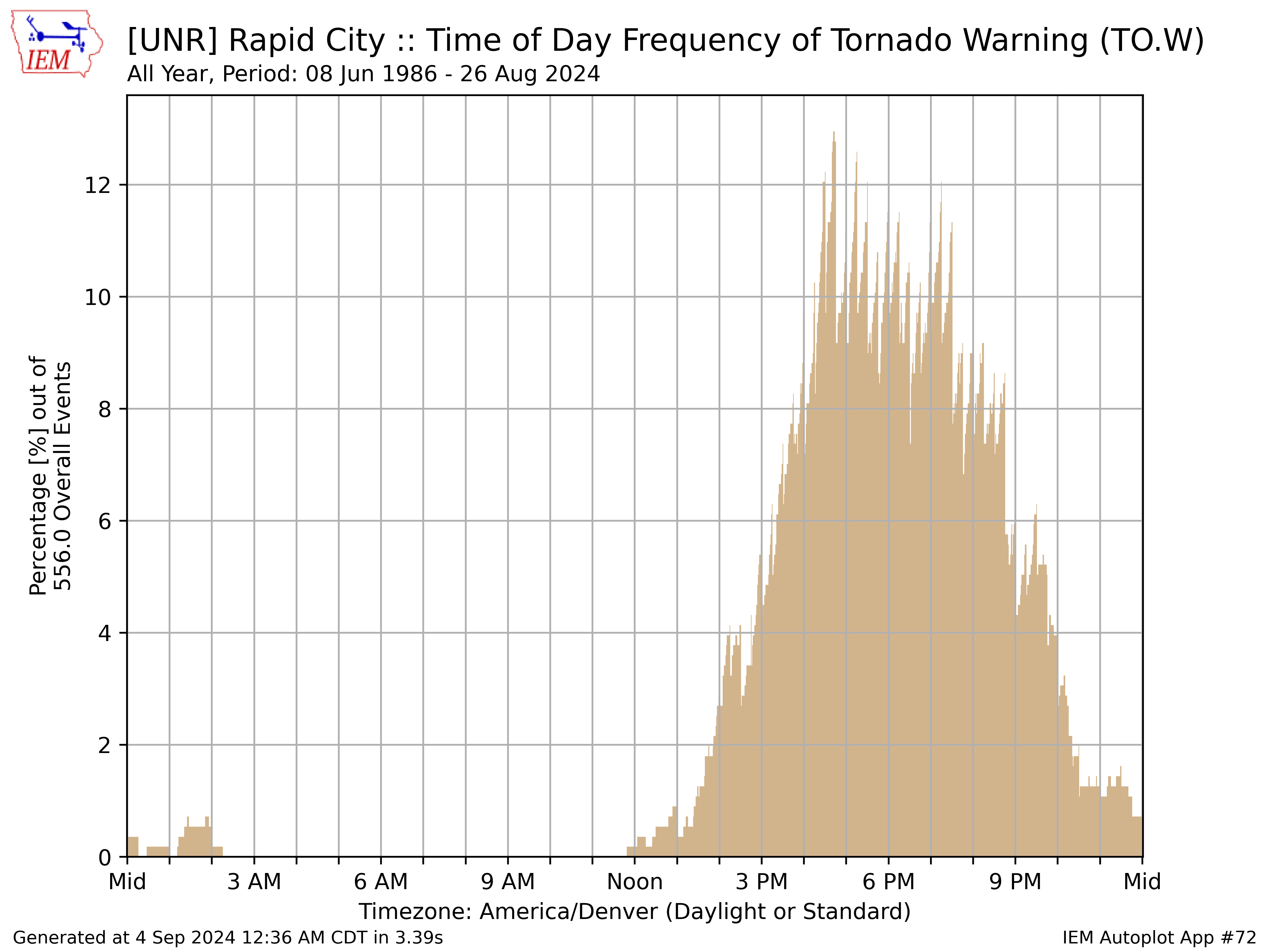
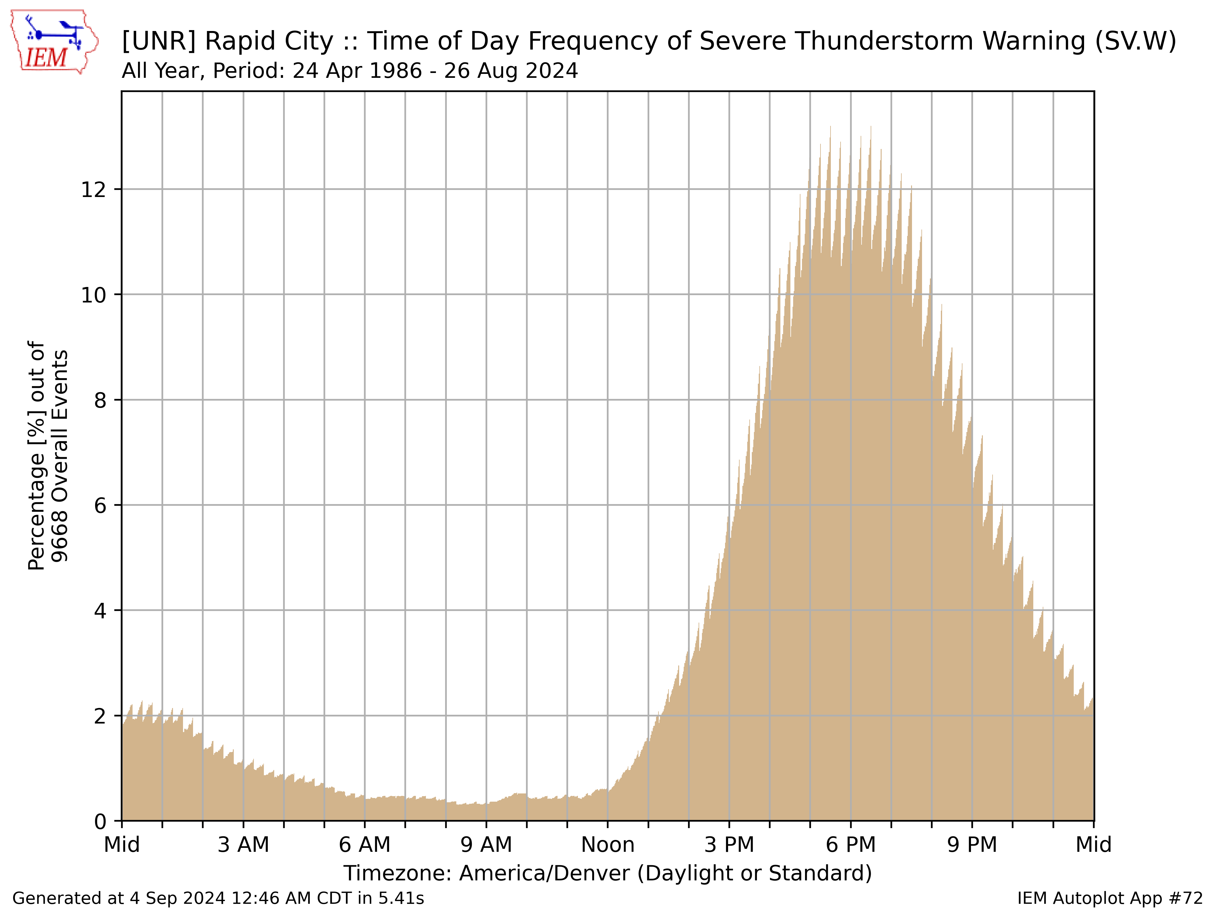
Diurnally, most of our tornado-favorable environments occur during the mid-afternoon through early evening, though the tornado threat can occasionally extend late into the overnight period.
 |
|
Percentage of tornado warnings issued at our office by a given time of day. Credit Daryl Herzmann at the Iowa Environmental Mesonet (https://mesonet.agron.iastate.edu/). |
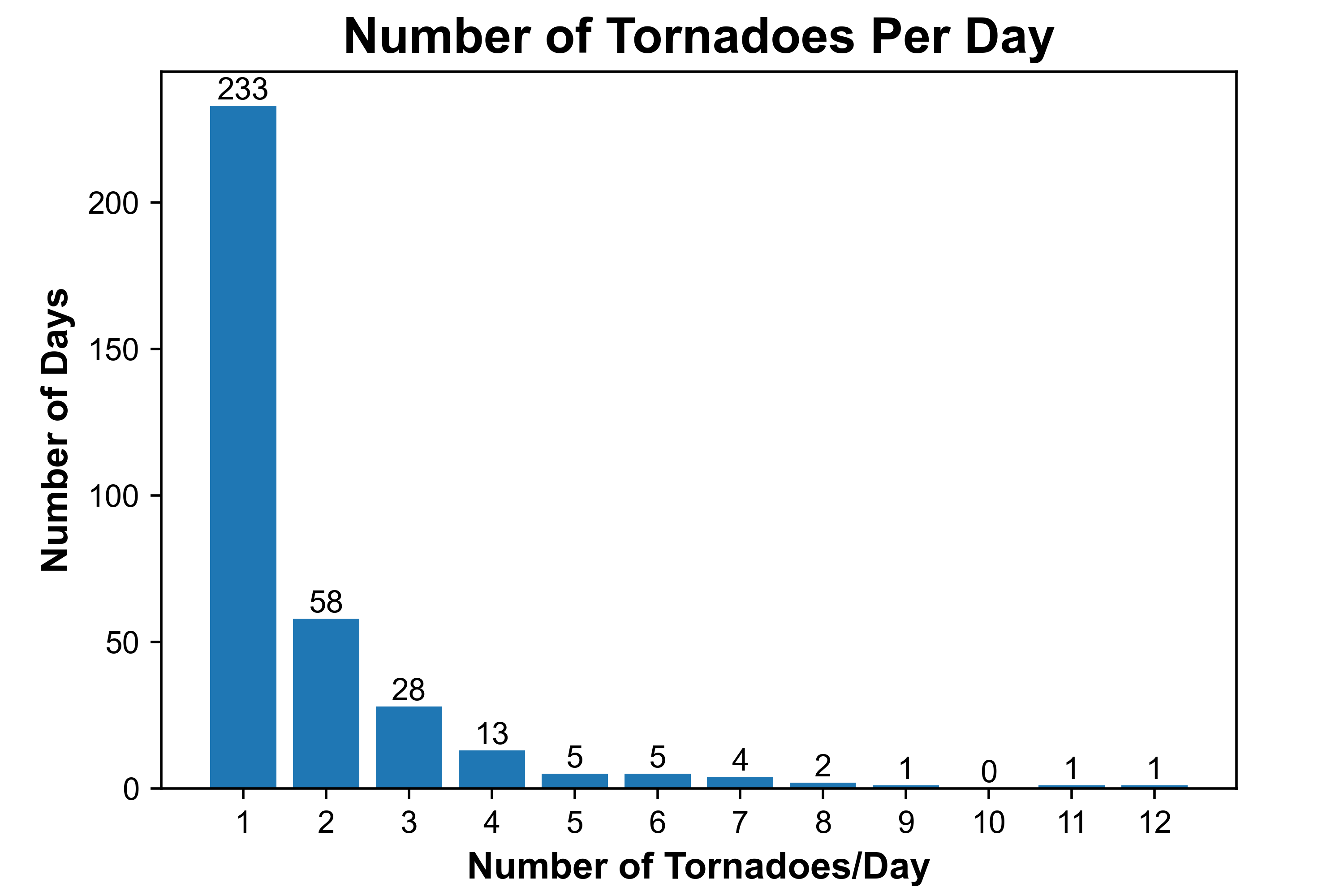
Tornado days with more than one or two tornadoes are fairly rare for our region. As shown by the graph below, on 233 of all days with tornadoes across northeastern WY or western SD since 1950, only one tornado occurred (about 66%), while on 58 days, only two tornadoes occurred (approximately 17%).
 |
|
Number of tornadoes per day on days with at least one tornado in the Rapid City, SD County Warning Area since 1950. |
Winds and Hail
As was the case with tornado environments, environments supporting severe thunderstorms are most common across our area from late spring through mid summer. Diurnally, the maximum occurrence time is again from mid-afternoon through the early evening; however, there is an increased likelihood of occurrence of straight-line winds and large hail from late evening through the overnight when compared to tornadoes.
 |
 |
| Severe thunderstorm warnings issued by our office per month, by year, since 1986. Credit Daryl Herzmann at the Iowa Environmental Mesonet (https://mesonet.agron.iastate.edu/). Note that because our office's county warning area expanded in 1996, you may note an associated change in our warning statistics. | Percentage of severe thunderstorm warnings issued at our office by a given time of day. Credit Daryl Herzmann at the Iowa Environmental Mesonet (https://mesonet.agron.iastate.edu/). |
Damaging Straight-Line Winds
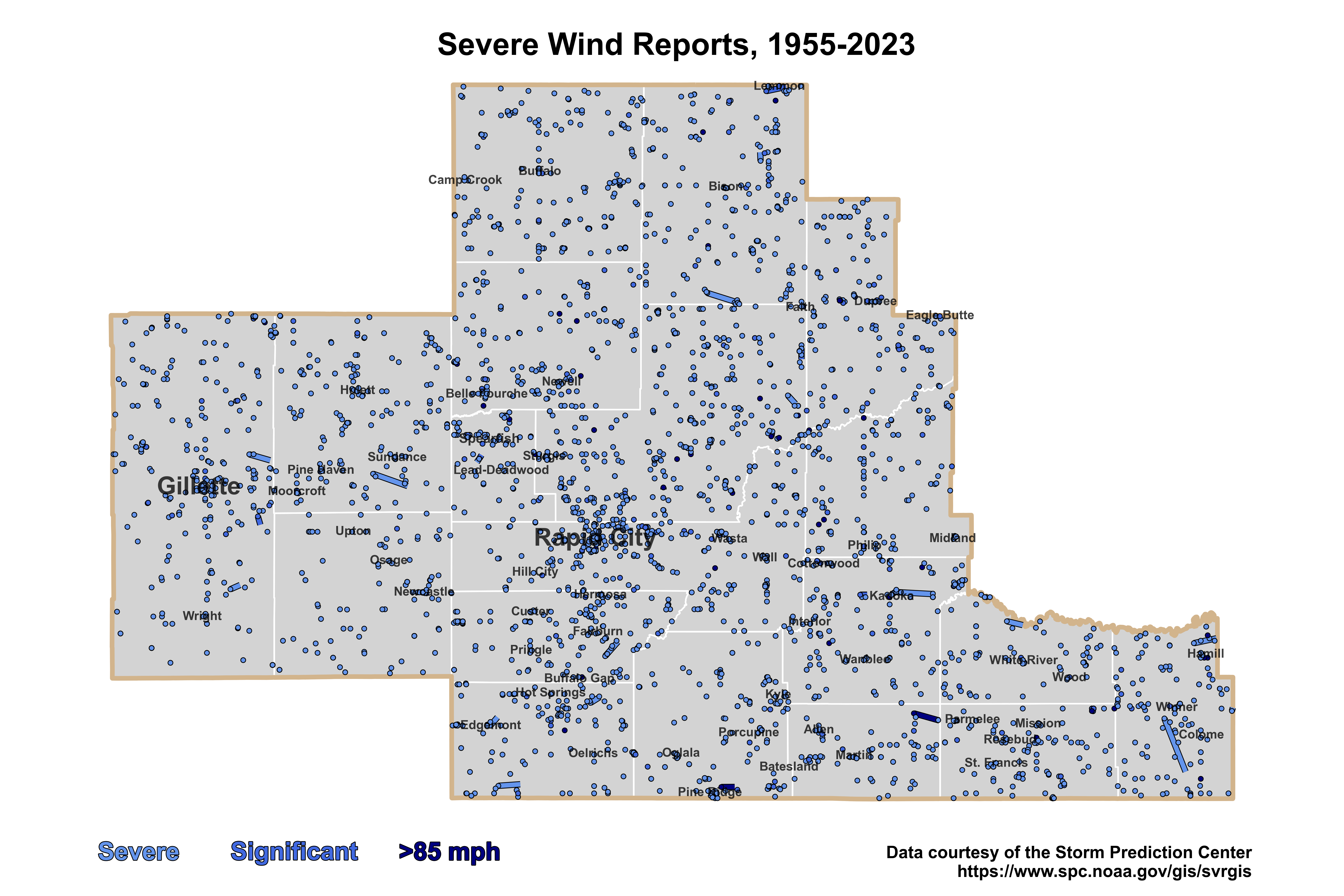
Strong winds can occur at all times of year across northeastern Wyoming and western South Dakota. However, here we are referring to those that occur in association with thunderstorms. Severe winds are defined as those that reach at least 50 kt (58 mph) or produce wind damage. Significant severe winds reach at least 65 kt (75 mph) or produce comparable damage.
 |
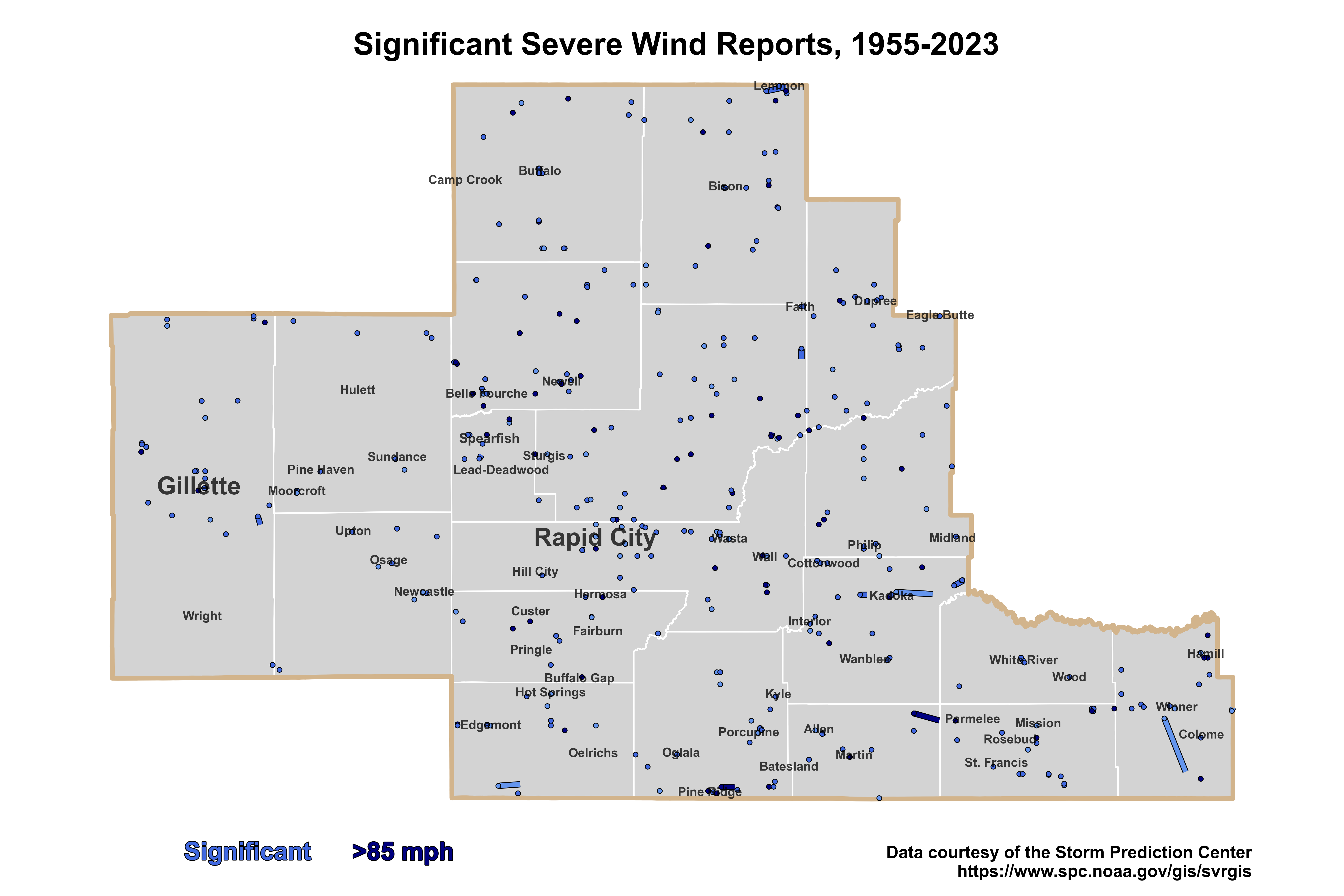 |
| Map of all severe (50 kt/58 mph or higher) straight-line wind reports for our area of responsibility from 1955 to 2023. | Map of all significant severe (65 kt/75 mph or higher) wind reports for our area of responsibility from 1955 to 2023. |
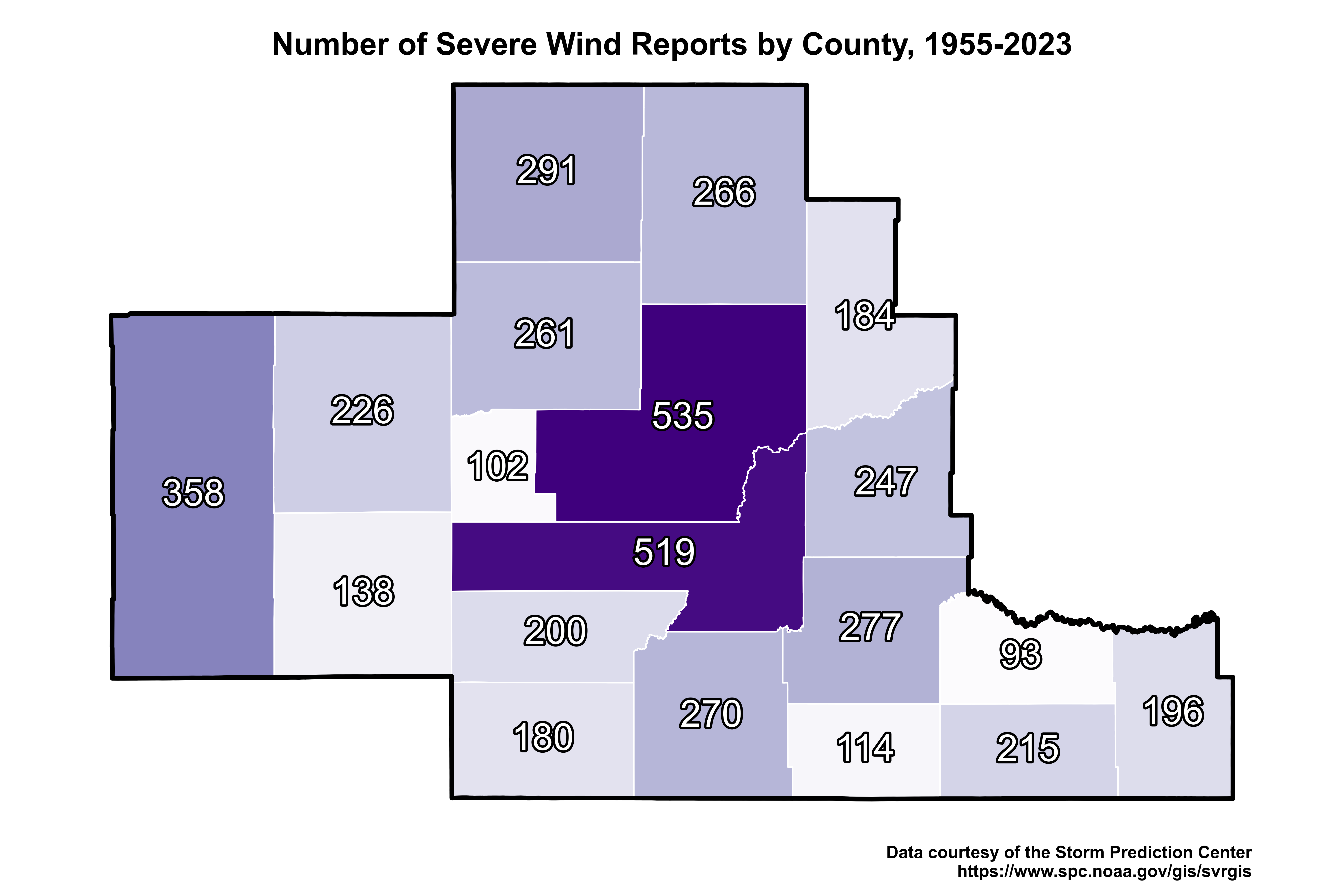 |
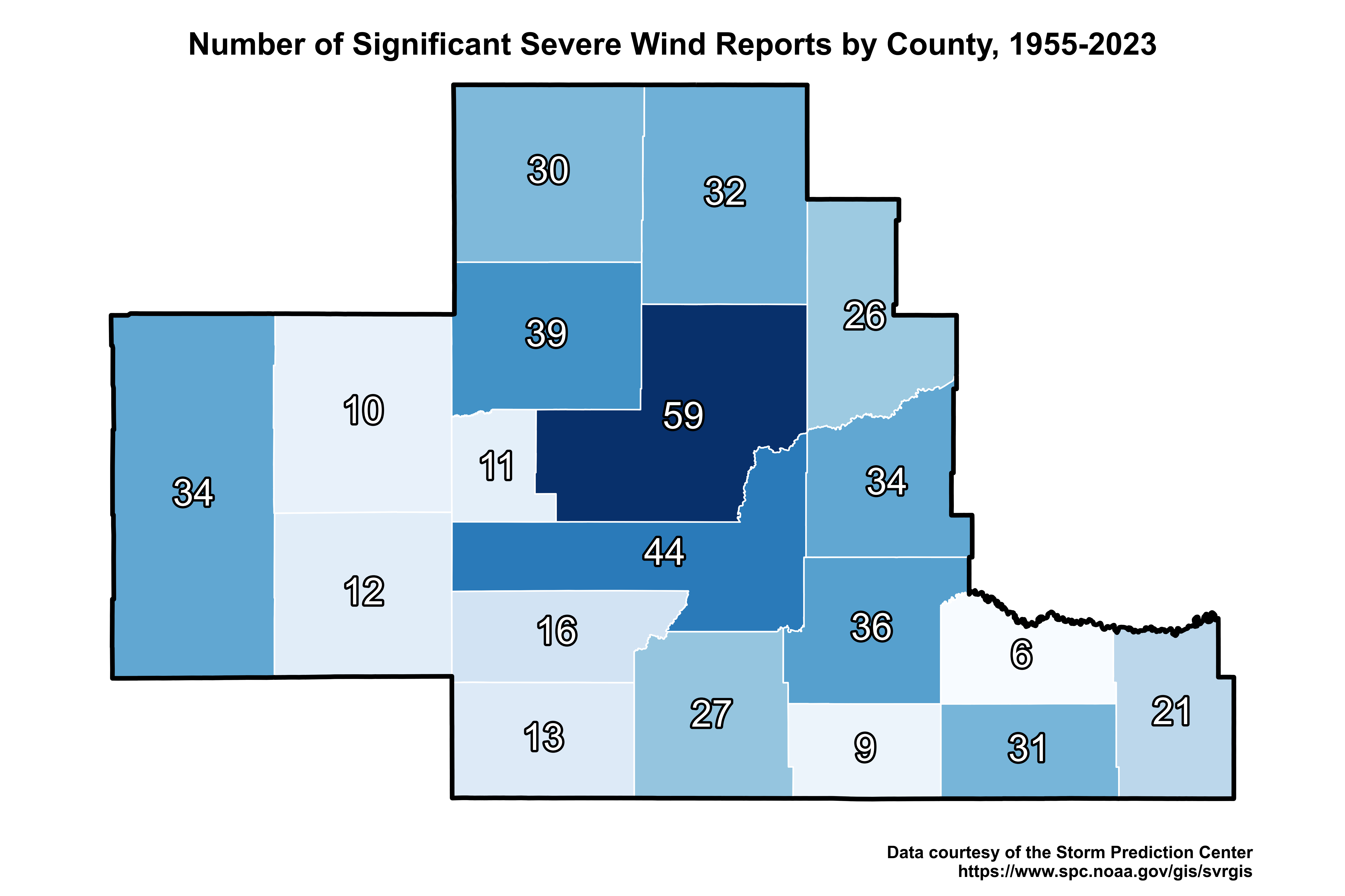 |
| Number of severe wind reports per county from 1955 to 2023. | Number of significant wind reports per county from 1955 to 2023. |
 |
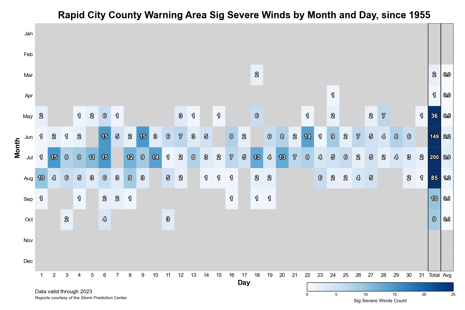 |
| Count of all severe wind reports for our area by day and month from 1955 to 2023, including monthly totals and averages. | Count of all significant severe wind reports for our area by day and month from 1955 to 2023, including monthly totals and averages. |
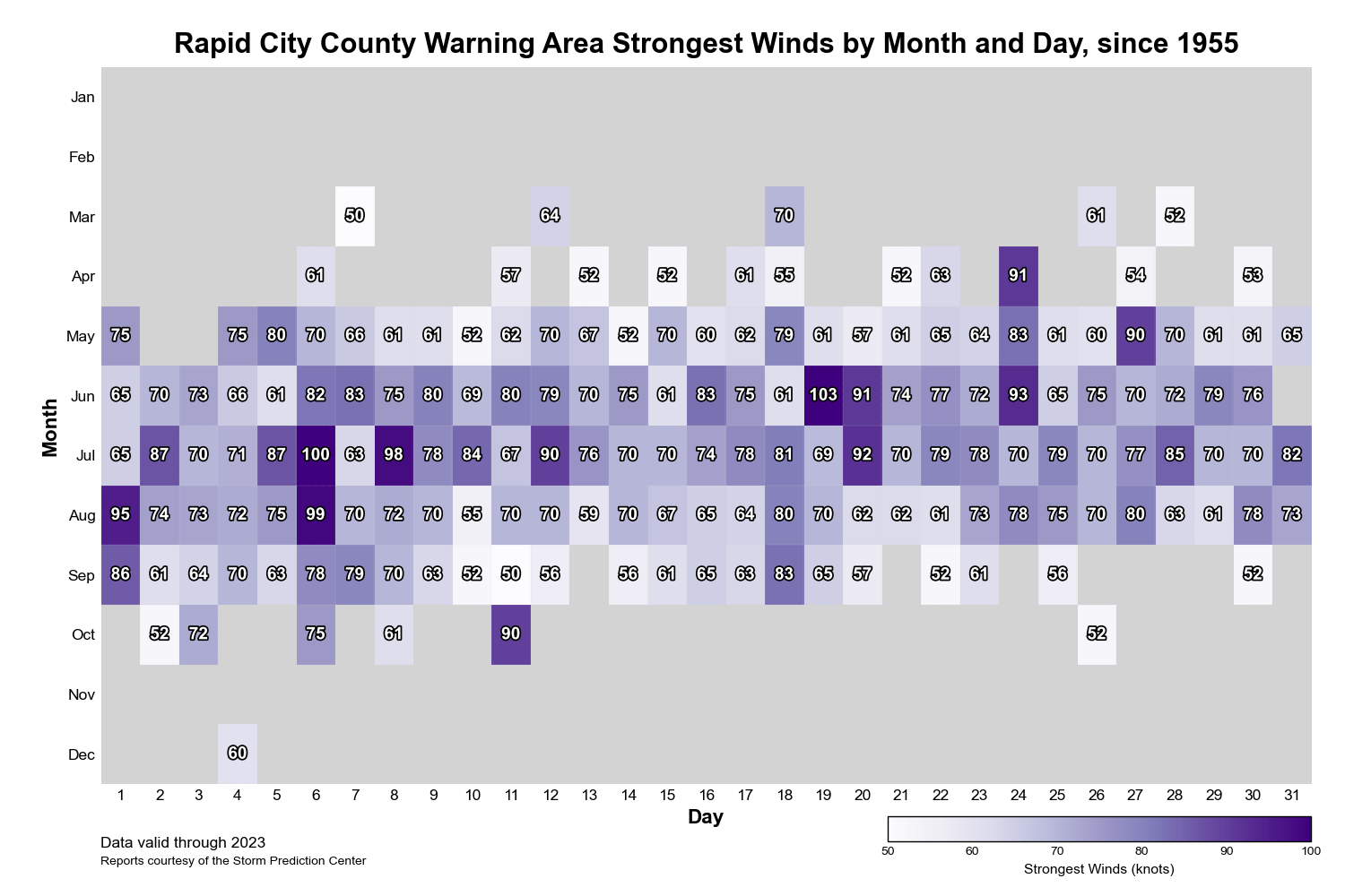 |
|
Maximum thunderstorm wind speed (kt; recorded or estimated) for our area by month and day from 1955 to 2023. Minimum of 50 kt (58 mph). |
Large Hail
Of all the severe hazards, large hail is the one that we experience most often across our area, particularly near and just east of the Black Hills. Golf ball-sized hail is common during the summer months, while several incidences of baseball-sized or larger hail are likely each year.
 |
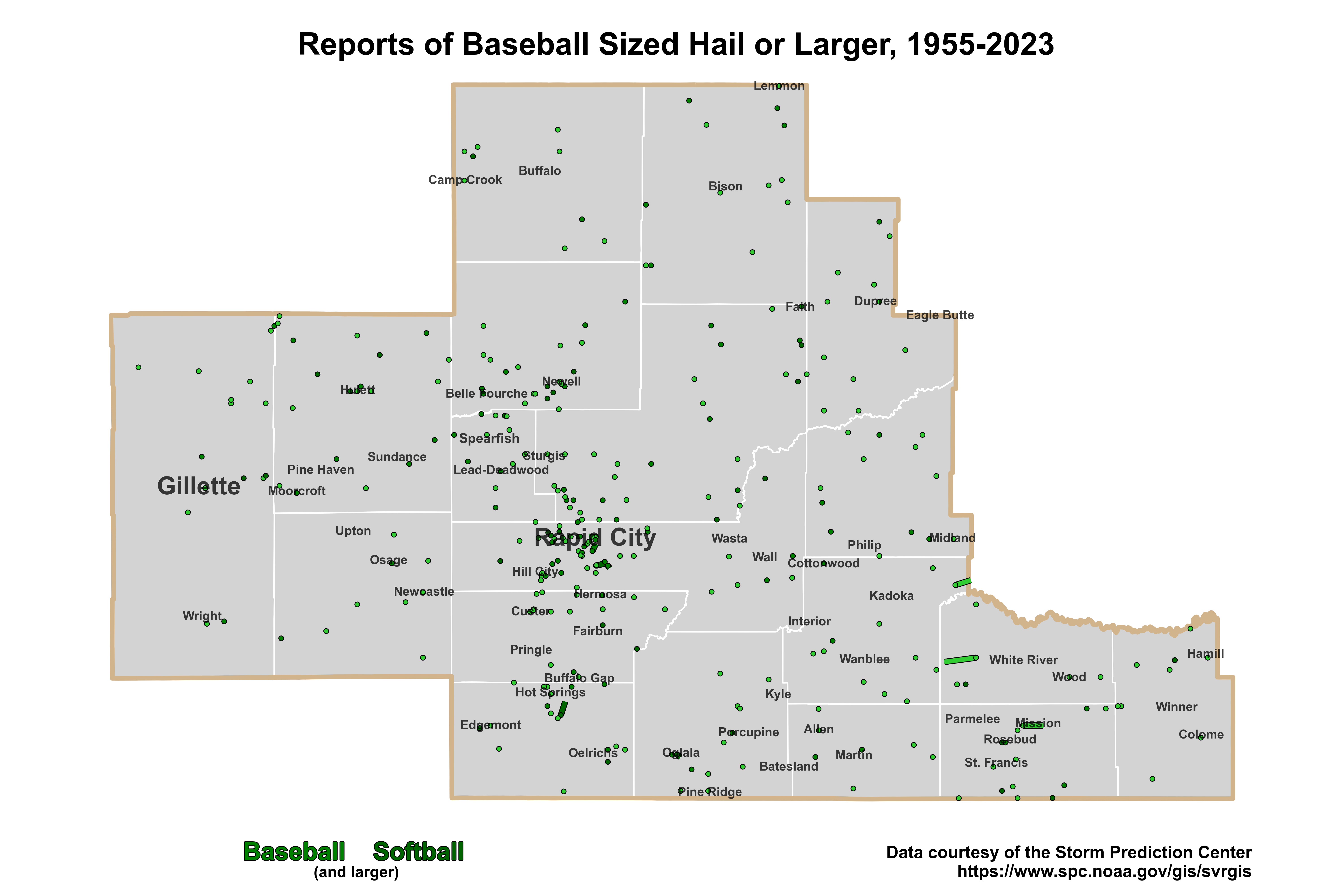 |
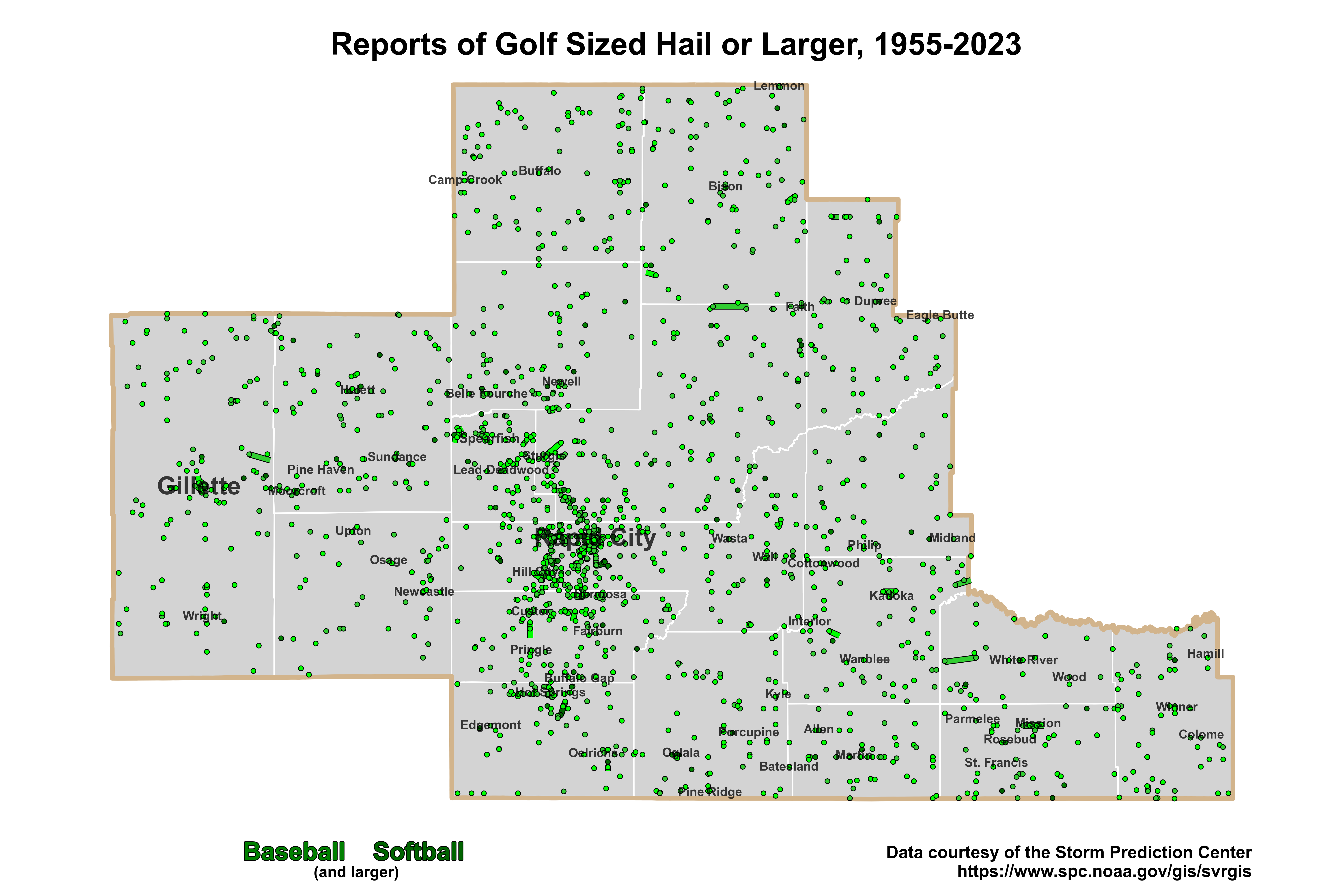
| Map of all golf ball-sized hail reports or larger for our area of responsibility from 1955 to 2023. | Map of all baseball-sized hail reports or larger for our area of responsibility from 1955 to 2023. |
 |
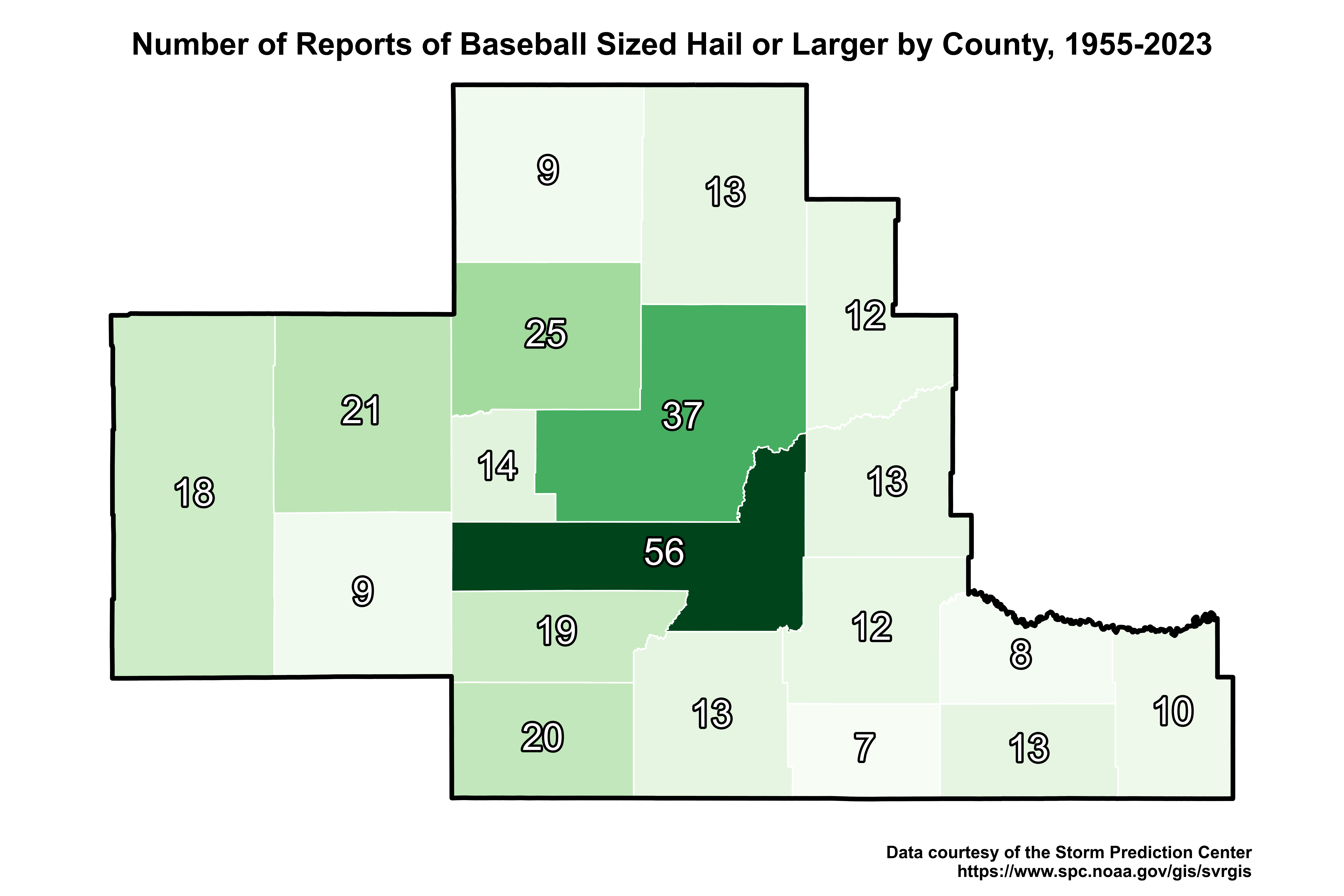 |
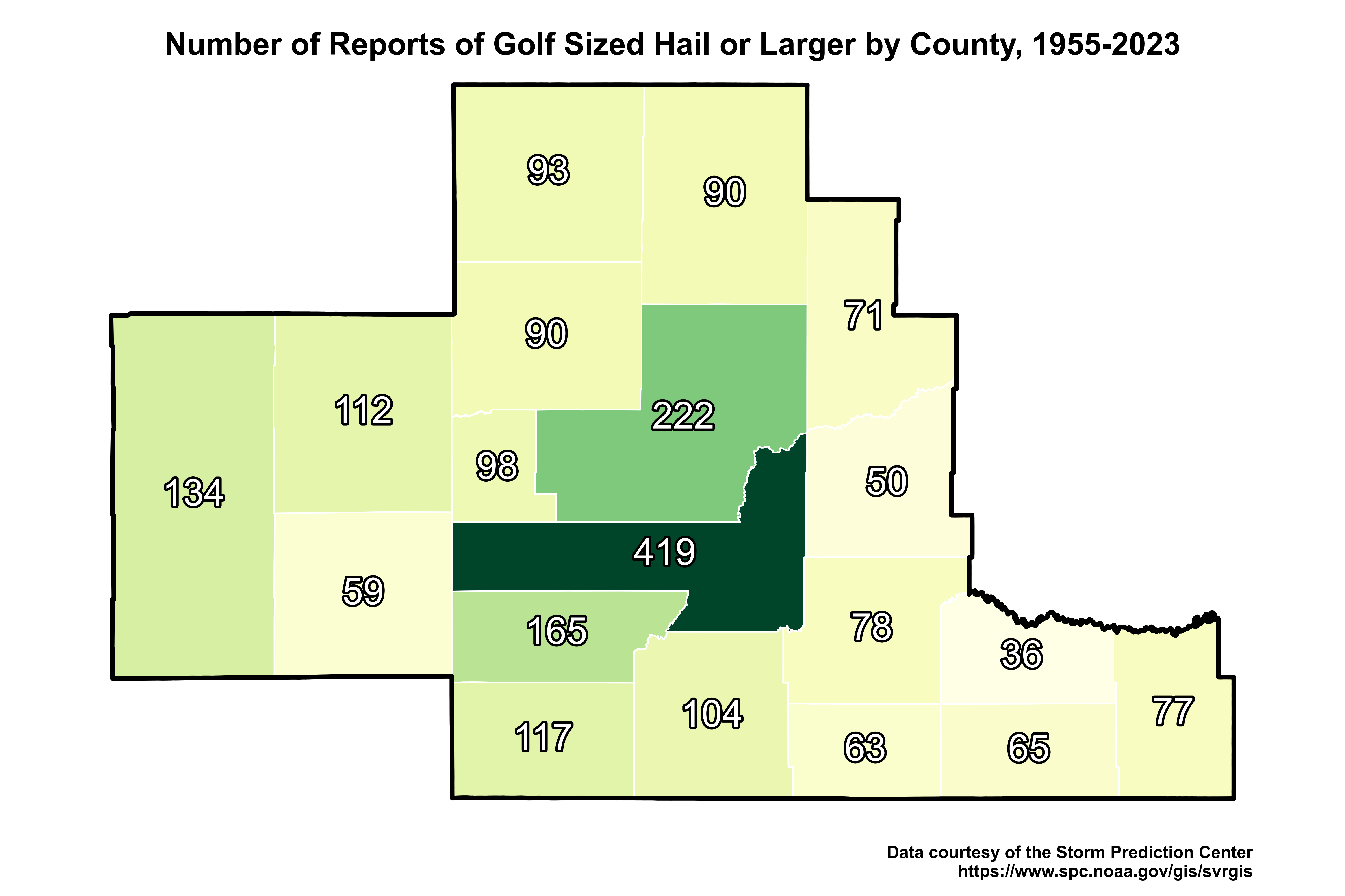
| Number of reports of golf ball-sized hail or larger per county from 1955 to 2023. | Number of reports of baseball-sized hail or larger per county from 1955 to 2023. |
 |
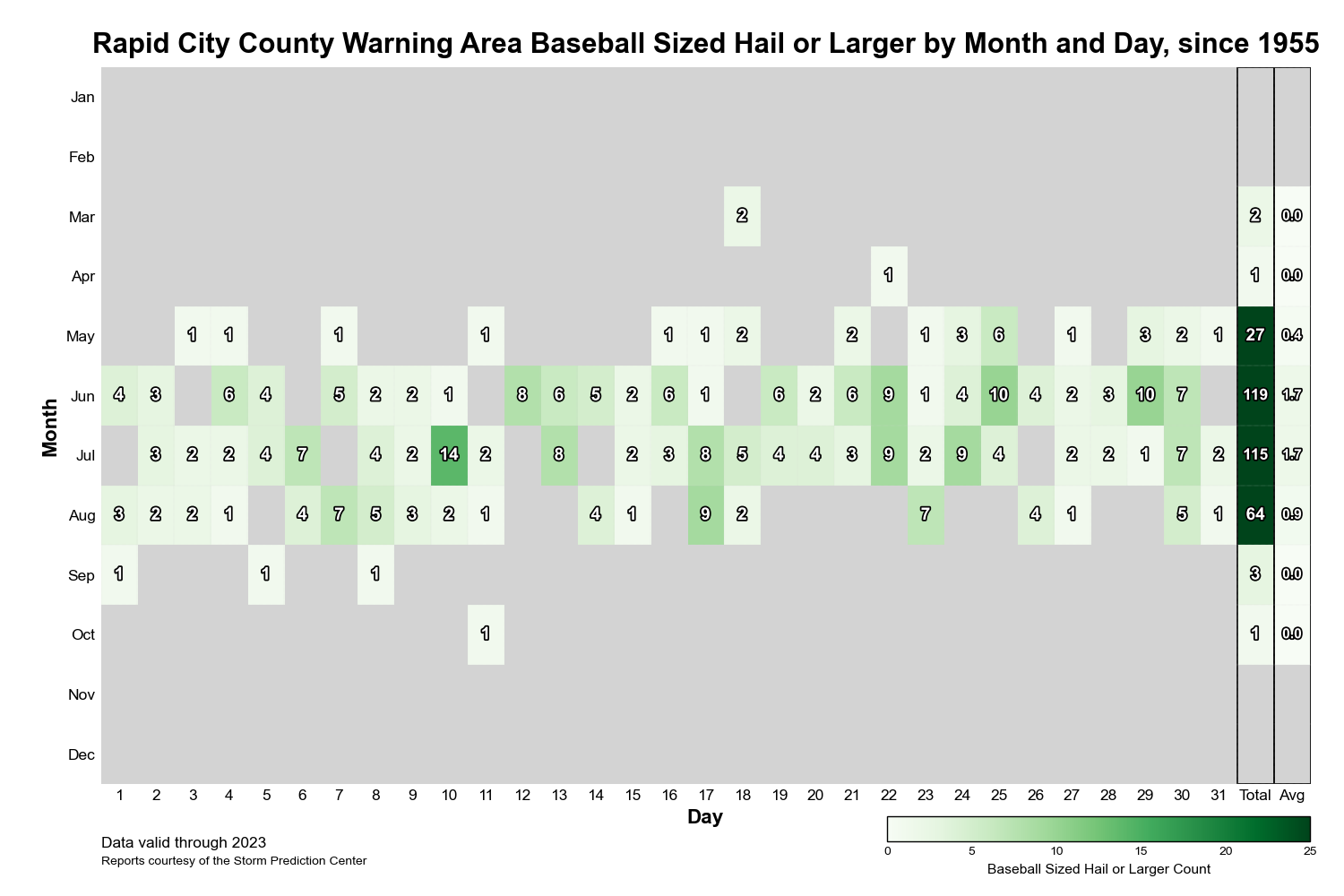 |
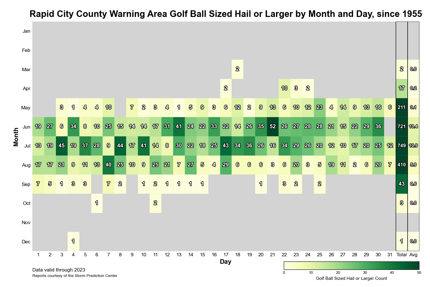
| Count of all reports of golf ball-sized hail or larger for our area by day and month from 1955 to 2023, including monthly totals and averages. | Count of all reports of baseball-sized hail or larger for our area by day and month from 1955 to 2023, including monthly totals and averages. |
 |
|
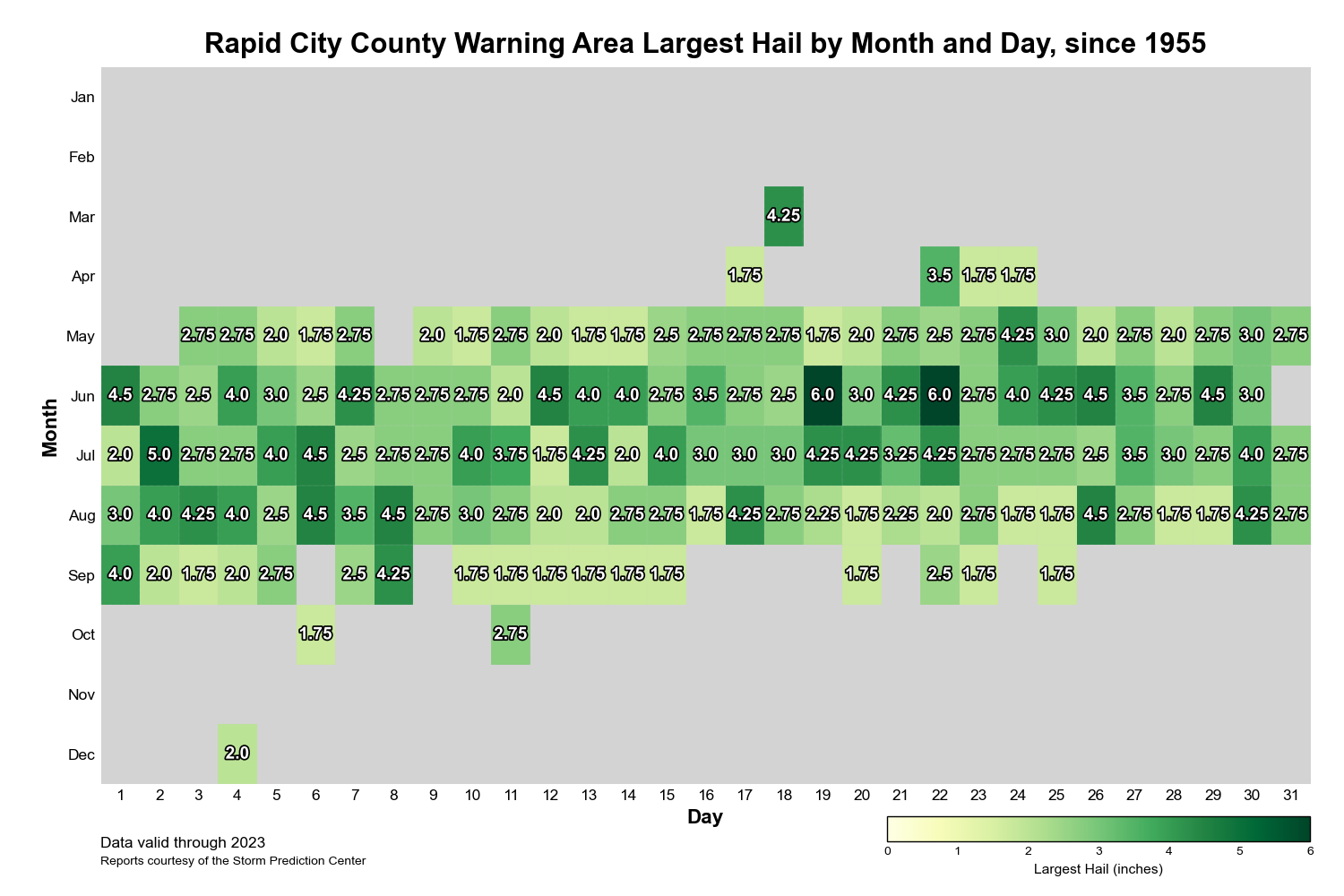
Largest hail report (in inches) for our area by month and day from 1955 to 2023. Minimum of penny-sized hail (0.75 inches in diameter). |
Top Tens
Strongest Tornadoes (1950-2022)
| Rank | Date | Start Time (MST) | Rating | Counties | Path Length | Width |
| 1st | May 8th, 1965 | 4:15 PM | 5 | Tripp | 30.1 miles | 1760 yards |
| 2nd | July 7th, 1969 | 4:15 PM | 4 | Harding | 1.8 miles | 133 yards |
| 3rd (tie) | August 6th, 1956 | 6:00 PM | 3 | Oglala Lakota, Bennett | 28.3 miles | 100 yards |
| June 6th, 1963 | 6:45 PM | 3 | Bennett | 24.4 miles | 1167 yards | |
| July 12th, 1965 | 5:40 PM | 3 | Crook, Lawrence | 20.8 miles | 1400 yards | |
| May 23rd, 1978 | 3:55 PM | 3 | Campbell | 14.5 miles | 180 yards | |
| June 25th, 1975 | 5:15 PM | 3 | Crook | 11.5 miles | 440 yards | |
| June 21st, 1983 | 7:51 PM | 3 | Ziebach | 6 miles | 300 yards | |
| June 1st, 2018 | 1:41 PM | 3 | Campbell | 3.78 miles | 200 yards | |
| June 28th, 2018 | 7:20 PM | 3 | Harding | 3.63 miles | 900 yards | |
| June 29th, 1993 | 9:50 AM | 3 | Crook, Lawrence | 3 miles | 150 yards | |
| July 18th, 1963 | 6:30 PM | 3 | Butte | 2.3 miles | 10 yards | |
| May 11th, 1991 | 7:10 PM | 3 | Meade | 2 miles | 500 yards | |
| July 18th, 1965 | 3:15 PM | 3 | Meade, Butte | 0.1 miles | 10 yards |
Largest Hail Reports (1955-2022)
| Rank | Date | Time (MST) | Size | County |
| 1st (tie) | June 22nd, 1968 | 5:45 PM | 6.0" | Custer |
| June 19th, 2015 | 7:20 PM | 6.0" | Butte | |
| 3rd | July 2nd, 1957 | 7:00 PM | 5.0" | Butte |
| 4th (tie) | July 6th, 1977 | 5:30 PM | 4.5" | Pennington |
| August 6th, 1986 | 6:15 PM | 4.5" | Tripp | |
| June 26th, 1998 | 4:15 PM | 4.5" | Meade | |
| June 12th, 2001 | 5:25 PM | 4.5" | Fall River | |
| August 26th, 2002 | 1:30 PM | 4.5" | Meade | |
| June 1st, 2015 | 5:55 PM | 4.5" | Meade | |
| June 19th, 2015 | 6:30 PM | 4.5" | Lawrence | |
| June 29th, 2018 | 3:49 PM | 4.5" | Butte |
Highest Wind Reports (1955-2022)
| Rank | Date | Time (MST) | Speed | County |
| 1st | June 19th, 2015 | 8:11 PM | 103 kt | Meade |
| 2nd | July 6th, 2016* | 3:44 PM | 100 kt | Meade |
| 3rd | August 6th, 1999* | 7:25 PM | 99 kt | Meade |
| 4th | July 8th, 2001 | 4:30 PM | 98 kt | Custer |
| 5th | August 1st, 2000 | 9:31 PM | 95 kt | Lawrence |
| 6th | June 24th, 2007 | 5:58 PM | 93 kt | Meade |
| 7th | July 20th, 2002 | 8:13 PM | 92 kt | Meade |
| 8th (tie) | April 24th, 1983 | 7:40 PM | 91 kt | Campbell |
| June 20th, 1999 | 9:49 PM | 91 kt | Harding | |
| 10th (tie) | May 27th, 1974 | 4:53 PM | 90 kt | Weston |
| July 12th, 1979 | 8:40 PM | 90 kt | Haakon | |
| October 11th, 1997* | 4:46 PM | 90 kt | Meade | |
| July 6th, 1998 | 5:00 PM | 90 kt | Perkins | |
| *Multiple reports from similar location and time that would make top ten list | ||||
Radar Characteristics
Supercells
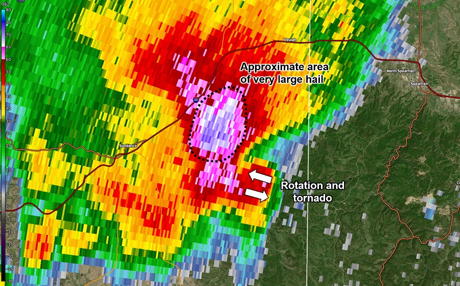
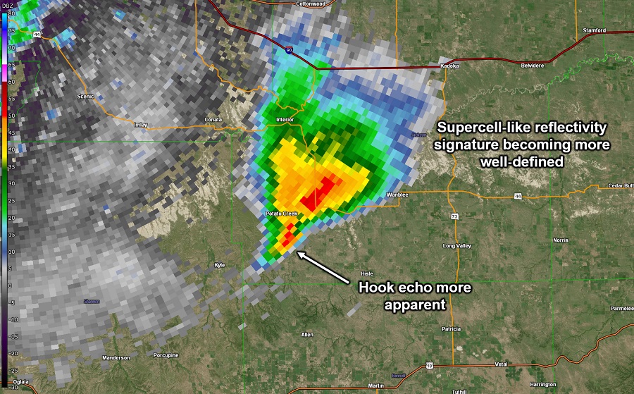
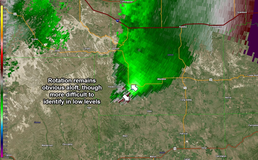
Most strong tornadoes and large hailstones are associated with supercells. Supercells are particularly strong thunderstorms that are characterized by a persistent, rotating updraft. Classic supercells, such as the example below, are typically identified on radar by their distinctive hook echo feature, which is evidence of rotation within the storm.
 |
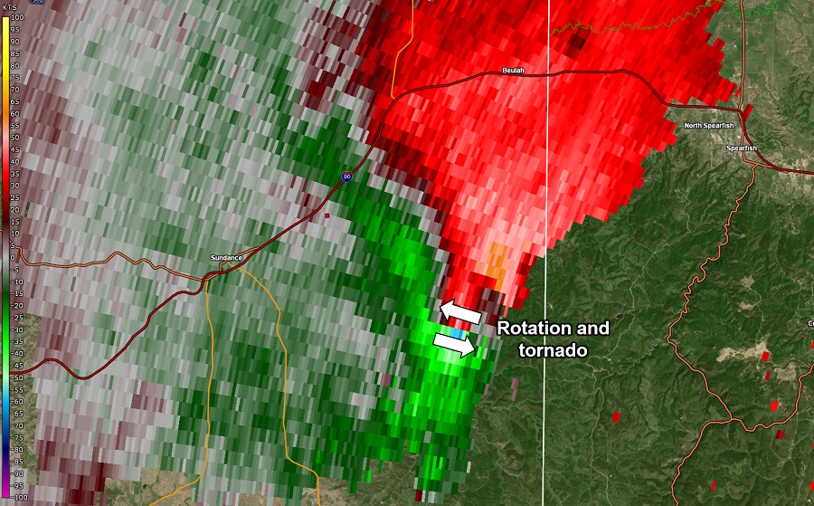 |
| Radar reflectivity (precipitation intensity) for the classic supercell associated with the June 29th, 2018 northern Black Hills EF3 tornado. Very large hail (3" in diameter) was also observed with this storm. Note the hook echo evident southeast of Sundance, coincident with the supercell's rotation. | Storm-relative velocity (wind speed) for the storm at left. Green and blue colors show winds blowing toward the radar, with reds and oranges showing winds away from the radar. Note the rotation evident southeast of Sundance, coincident with the supercell's hook echo. |
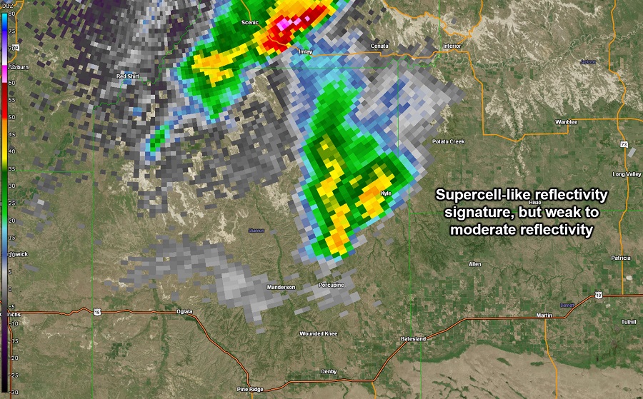
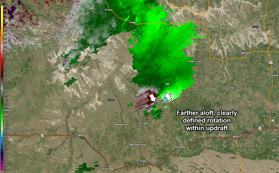
In addition to classic supercells, there are also two other types of supercells: "low-precipitation (LP)" and "high-precipitation (HP)". LP supercells tend to lack the familiar hook echo feature on radar imagery and are generally associated with less rain and hail. In addition, LP supercells often do not produce tornadoes, though they can produce large hail or evolve into classic or HP supercells.
 |
 |
| Radar reflectivity (precipitation intensity) for an LP supercell on June 7th, 2005, which later produced a tornado and hail up to 2.5" in diameter once it transitioned to a classic supercell. | Storm-relative velocity (wind speed) at the 1.5 degree radar tilt for the storm at left. Green and blue colors show winds blowing toward the radar, with reds and oranges showing winds away from the radar. |
 |
 |
| Radar reflectivity (precipitation intensity) for the storm above as it transitioned to a classic supercell. At this time, two tornadoes were reportedly in progress. | Storm-relative velocity (wind speed) for the storm at left. Green and blue colors show winds blowing toward the radar, with reds and oranges showing winds away from the radar. |
HP supercells, on the other hand, are associated with larger amounts of rain and hail and can pose a significant straight-line wind threat, particularly if they evolve into a bow echo (which we will talk more about shortly). Of the three, classic supercells are the most likely to produce tornadoes.
 |
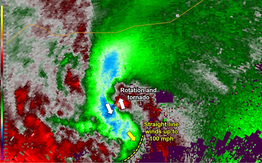 |
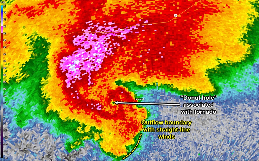
| Radar reflectivity (precipitation intensity) for a classic/HP supercell on June 19th, 2015, responsible for a tornado, hail of over softball size, and 100 mph straight-line winds. | Storm-relative velocity (wind speed) for the storm at left. Green and blue colors show winds blowing toward the radar, with reds and oranges showing winds away from the radar. |
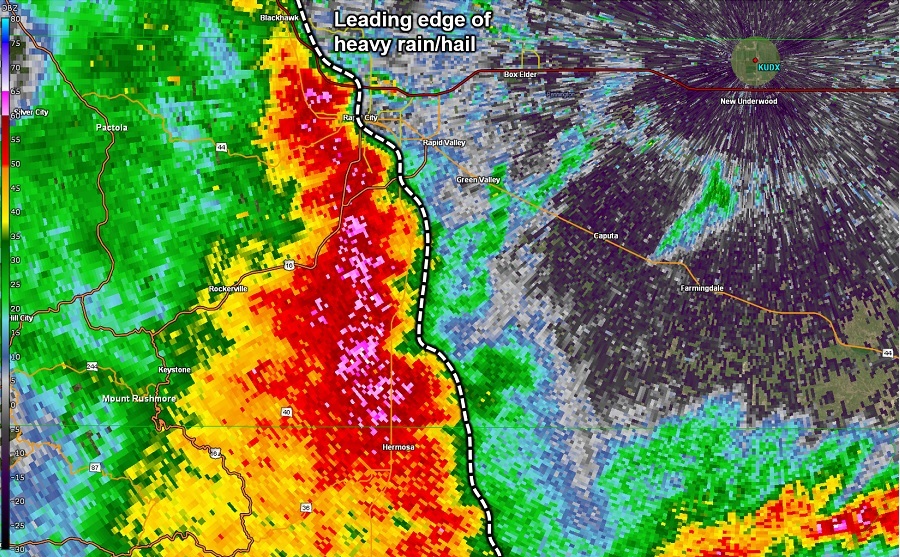
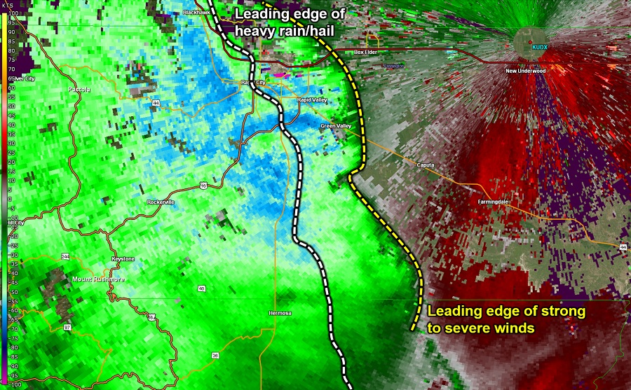
The case above was unique because all three severe hazards were present with one supercell: a tornado, hail up to 6" in diameter, and straight-line winds up to 100 mph. Here, a couple of interesting features are evident. First, a "donut hole" coincident with rotation west of Hereford is evidence of a tornado. This is sometimes present when a large, rain-wrapped tornado is close to a radar. In this case, the tornado was less than 20 miles from our New Underwood radar. The second feature is an outflow boundary, particularly evident as an arc of enhanced winds approaching the radar, to the southeast of the tornado's location. This storm, which was borderline classic/HP, later fully evolved into an HP supercell, predominantly producing damaging straight-line winds as it moved into eastern Pennington County.
Some additional recent supercell examples include:
Quasi-Linear Convective Systems (QLCSs), aka Squall Lines
Compared to supercells, QLCSs account for a larger fraction of severe straight-line winds and fewer tornadoes and large hailstones. However, all three hazards remain possible with QLCSs, and they occasionally produce significant tornadoes and hail in addition to significant straight-line wind damage.
On radar, QLCSs generally appear like a line of strong thunderstorms, potentially with some cusps, wiggles, appendages, or breaks within the line. Severe straight-line winds tend to occur along the leading edge of the line.
 |
 |
| Radar reflectivity (precipitation intensity) for a QLCS on July 6th, 2016 as it was producing 60 mph winds and hail up to 3" in diameter. | Base velocity (wind speed) for the squall line at left. Green and blue colors show winds blowing toward the radar, which is located east of the squall line near New Underwood, with red and oranges showing winds blowing away from the radar. |
 |
 |
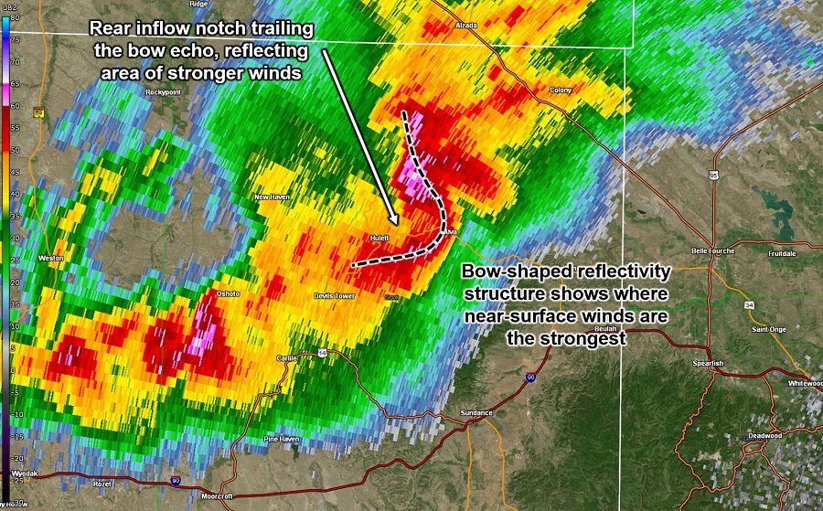
| Radar reflectivity (precipitation intensity) for the QLCS above later in its lifetime, as it was producing a tornado and straight-line winds to 60 mph. The QLCS went on to produce straight-line winds over 110 mph near the bowing feature annotated above. | Base velocity (wind speed) for the squall line at left. Green and blue colors show winds blowing toward the radar, which is located east of the squall line near New Underwood, with red and oranges showing winds blowing away from the radar. |
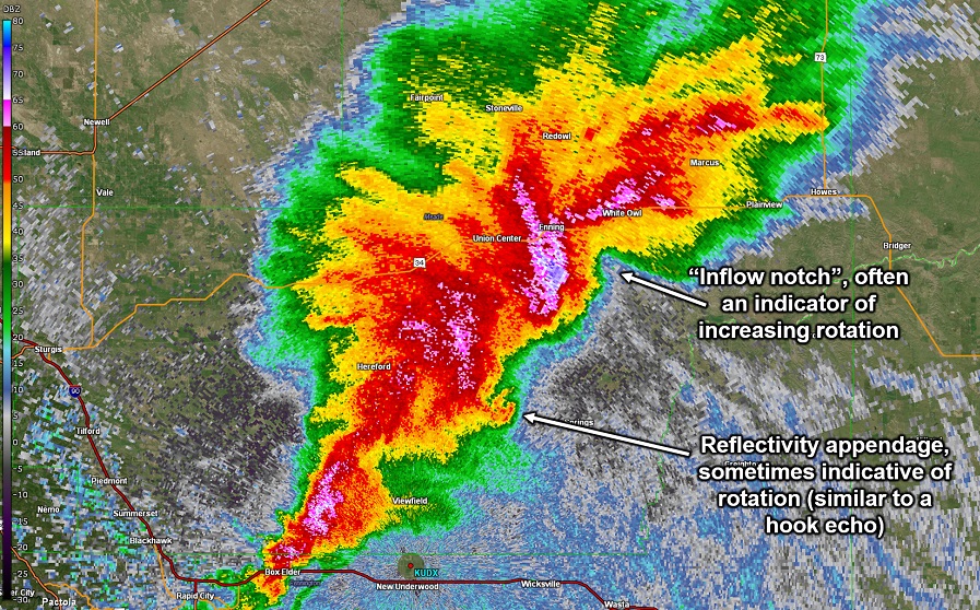
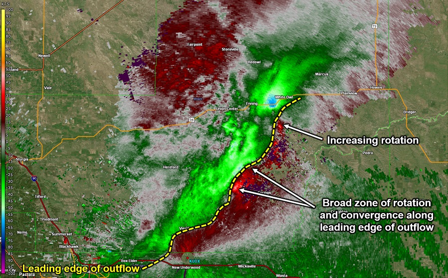
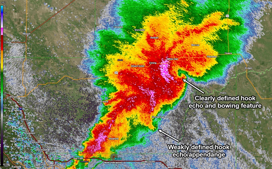
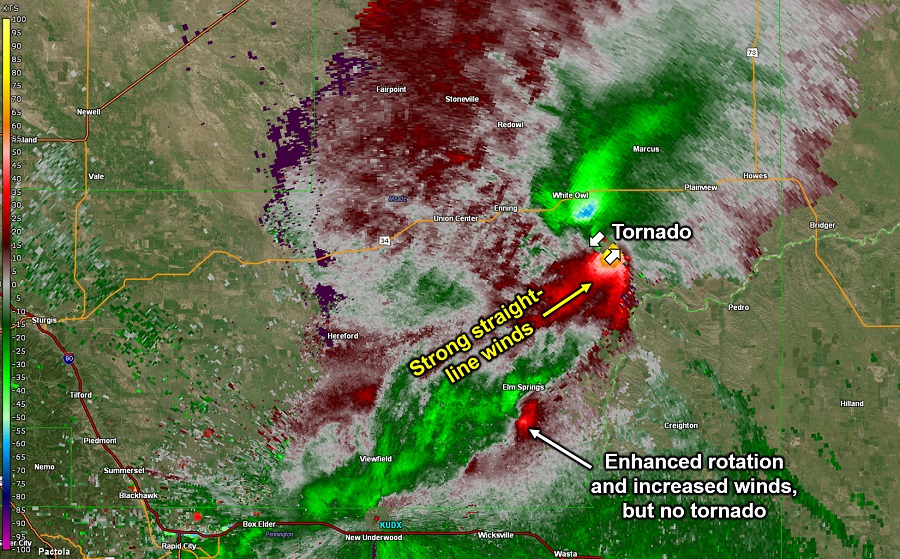
The high-impact QLCS above produced all severe hazards across our area, including large hail up to 3" in diameter, straight-line winds with recorded speeds of over 110 mph, and a tornado. As shown here, tornadoes within QLCSs tend to be associated with embedded inflow notches (areas of relatively weak reflectivity compared to surroundings) and hook echoes. However, it is possible to have reflectivity signatures that resemble hook echoes in the absence of a tornado. The strongest straight-line winds tend to occur in bowing features, which can sometimes be coincident with, or look like, a hook echo. Another recent example of a QLCS that produced large hail, damaging straight-line winds, and a tornado across our area is the event on June 12, 2017.
In some QLCSs, strong winds may even precede the arrival of any precipitation, as in the case below.
 |
 |
| Radar reflectivity (precipitation intensity) for a squall line on June 27th, 2017, which produced widespread 60-75 mph winds across the Black Hills and onto the South Dakota plains. | Base velocity (wind speed) for the squall line at left. Green and blue colors show winds blowing toward the radar, which is located east of the squall line near New Underwood. |
QLCSs are notoriously challenging for radar operators due to their fairly large scale and rapid evolution when compared to supercells. Knowledge of the features above help identify the potential for locally intense winds or tornadoes within the broader system.
A subset of QLCSs are known as bow echoes. These are identified on radar by their distinctive bow-shaped reflectivity signatures and are typically associated with intense straight-line winds.
 |
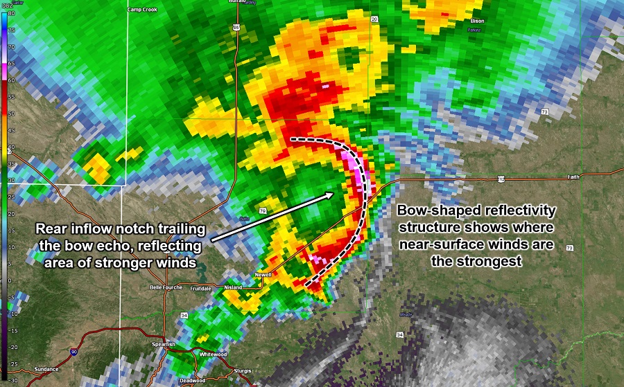 |
| Radar reflectivity (precipitation intensity) for a bow echo on June 17th, 2015, which produced widespread tree damage, winds over 60 mph, and a tornado across northeastern Wyoming and the Black Hills. | Radar reflectivity (precipitation intensity) for a bow echo on July 2nd, 2005, which produced widespread 80-100 mph winds across northeastern Wyoming and much of northern South Dakota. |
Some bow echoes, such as the July 2nd, 2005 example above, are particularly prolific, producing widespread significant straight-line winds over a large area and a long period of time. These are referred to as derechoes. While derechoes are more common east of our area, we can still expect to experience one across northeastern Wyoming or western South Dakota every five to ten years or so. You can learn more about derechoes from the Storm Prediction Center here.
Recent local examples of QLCSs include:
Severe Weather Environments
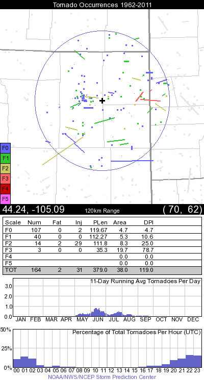
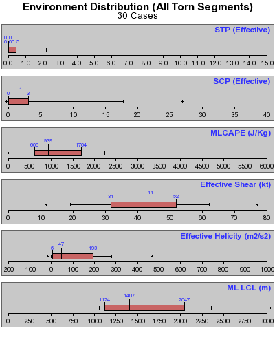
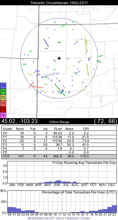
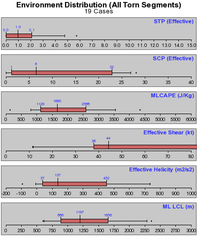
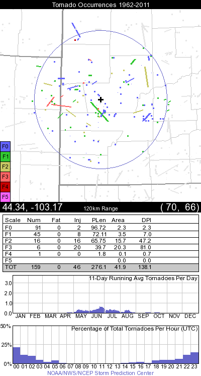
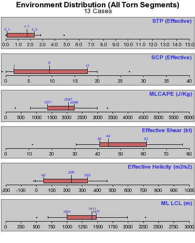
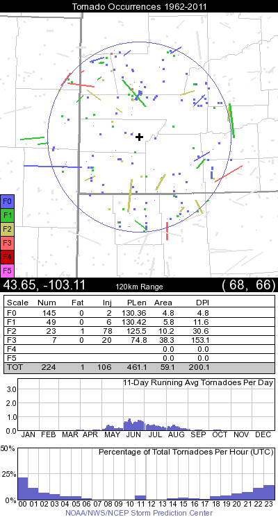
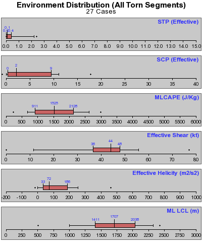
Tornado Environments
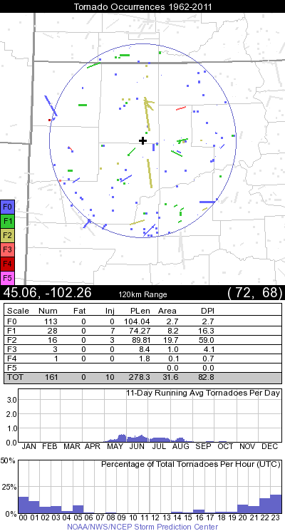
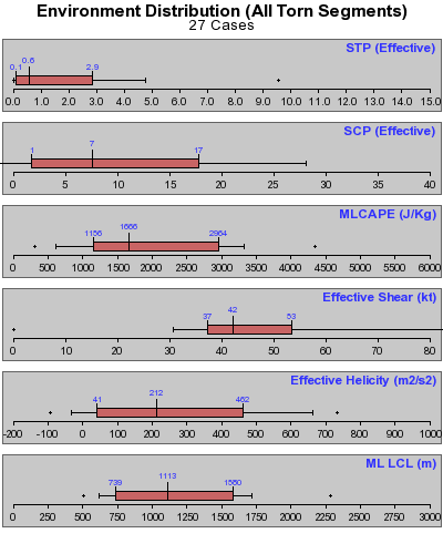
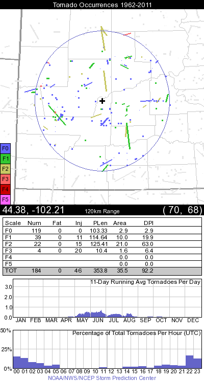
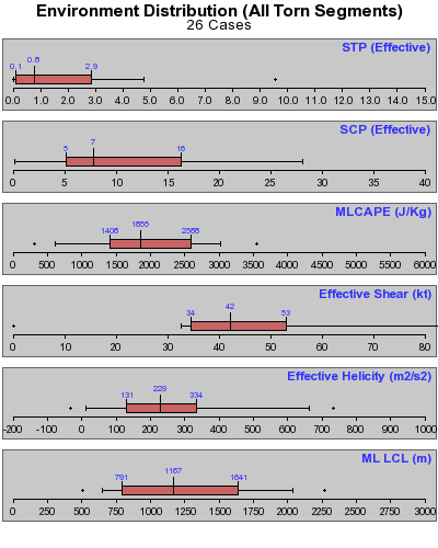
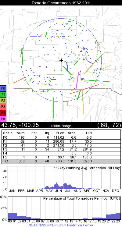
The following plots are provided courtesy of the Storm Prediction Center (SPC). Data for more locations across the contiguous U.S. can be found at their Tornado Environment Browser webpage.
Environmental parameters listed in the plots on the right include the Significant Tornado Parameter, Supercell Composite Parameter, Mixed-Layer Convective Available Potential Energy, Effective Shear Magnitude, Effective Storm-Relative Helicity, and the Mixed-Layer Lifted Condensation Level.
 |
 |
 |
 |
 |
 |
 |
 |
 |
 |
 |
 |
 |
 |
 |
 |
 |
 |
 |
 |
 |
Severe Weather Environments
Significant Severe Environments
Environments that support damaging straight-line winds often differ from those that produce giant hail or tornadoes. However, some environments are capable of supporting damaging tornadoes, significant straight-line winds, and giant hail all on the same day. Here, we investigate the characteristics of environments that supported significant tornadoes (EF1 or greater), straight-line winds (65 knots or stronger), and hail (2" in diameter or larger) across our area from 2006 to 2013, including their similarities and differences. Environmental data shown is from archived Storm Prediction Center (SPC) mesoanalysis data, provided by Techniques Development Meteorologist Andy Dean.
Below, report data are split into the following categories:
| Label | Description (All data 2006-2013) |
| EF1 Tors | All EF1 or stronger tornadoes for our area |
| Sig Winds | All straight-line wind reports of 65 kt or stronger |
| Sig Hail | All hail reports of 2" in diameter or larger |
| HI Winds | Straight-line wind reports of 65 kt or stronger from days with at least three of such reports, with no significant tornadoes or significant hail reports |
| HI Hail | Hail reports of 2" in diameter or larger from days with at least five of such reports, with no significant tornadoes or significant hail reports |
| Hail & Wind | Straight-line wind reports of 65 kt or stronger and hail reports of 2" in diameter or larger from days with at least one of each report |
| HI All | EF1 or stronger tornado reports, straight-line wind reports of 65 kt or stronger, and hail reports of 2" in diameter or larger from days with at least one of each report |
For each given report, data represents the environment according to SPC mesoanalysis data at the nearest grid point for the most recent hour.
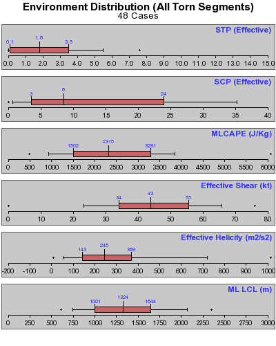
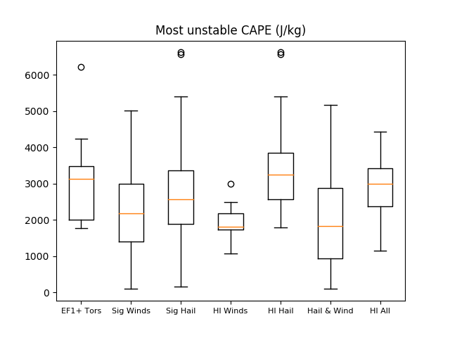
Two key ingredients for the development of strong to severe thunderstorms are instability, typically measured by Convective Available Potential Energy, or CAPE, and deep-layer vertical wind shear. Generally speaking, instability and shear provide fuel for the storms and promote their longevity by separating the updraft and downdraft, respectively.
 |
 |
| Box-and-whisker plots for the most unstable parcel's CAPE for the given subsets of severe weather reports, described above. Boxes encompass the 25th to 75th percentiles of the data, with orange lines depicting median values. Whiskers extend to 1.5 times the interquartile range. Circles show outliers. | As at left, except for 0-6 km shear vector magnitude. |
Based on climatology, most EF1 or stronger tornadoes and significant hail and straight-line wind events across our area require at least moderate CAPE, as the median values for all subsets are approximately 2000 J/kg or larger. Days with multiple significant straight-line wind reports but lacking tornadoes or significant hail reports tend to have somewhat lower CAPE, based on this dataset. Likewise, deep-layer shear (here shown over the 0-6 km layer) tends to be fairly large, with 25th percentile values of at least 35 kt for all subsets. Deep-layer shear is particularly large near tornadoes and on days when all significant severe hazards are observed.
Vertical wind shear over shallower layers, closer to the ground, have been shown to relate to the potential for tornadoes and damaging straight-line winds. In particular, increasing low- and mid-level wind shear tends to correlate to an increasing threat for both hazards. In our area, this rings true for tornadoes, as shown below.
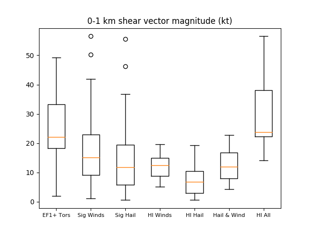 |
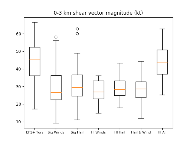 |
| As above, but for 0-1 km shear vector magnitude. | As above, except for 0-3 km shear vector magnitude. |
Rather than using fixed-layer shear, recent research has suggested that measuring shear over a dynamic layer relative to the storm's likely depth and source region is more useful. This contention led to the development of the "effective" bulk wind difference and "effective" storm-relative helicity. The effective shear layer effectively spans the lower half of the storm depth, while the effective storm-relative helicity layer is based on the layer of instability extending from the surface. Storm-relative helicity essentially measures the amount of streamwise vorticity entering the updraft; a higher value suggests a greater potential for rotating updrafts and, thus, supercell development.
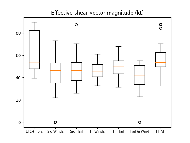 |
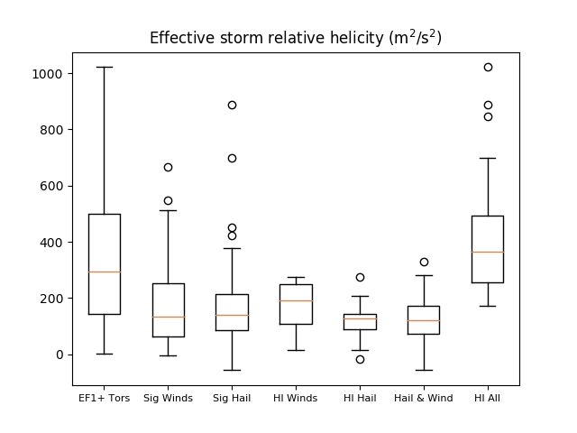 |
| As above, but for effective shear vector magnitude. | As above, except for effective storm-relative helicity. |
|
As was the case with fixed-layer shear parameters, values of effective layer bulk shear magnitude and storm-relative helicity are generally higher near tornado reports and on days when all three hazards occurred. This reinforces the importance of shear in the production of severe weather and, in particular, impactful tornadoes. Another term commonly considered when investigating tornado potential is the lifted condensation level (LCL) height, which essentially quantifies the height of the cloud base. Generally, lower cloud bases (and thus, LCLs) are consistent with an increased potential for tornadoes. It is believed that lower cloud bases limit evaporation of precipitation between the cloud, which prevents downdrafts from becoming too strong. Too strong of a downdraft could disrupt storm balance and promote a straight-line wind threat, rather than a tornado threat. In our dataset, LCLs were slightly lower near tornadoes and on days when all three hazards were observed. The most distinct differences were found between high-impact days with all hazards versus those with just hail and wind. |
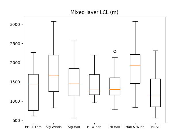 |
| As above, except for mixed-layer lifted condensation level height. |
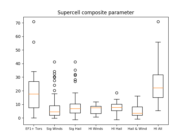
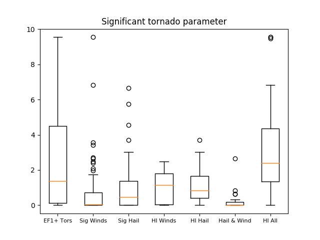
Research over the last two decades has indicated that combining favorable environmental variables into composite parameters is sometimes more useful than investigating individual terms on their own. Two such examples are the supercell composite parameter (SCP), meant to identify environments favorable for the development of supercells, and the significant tornado parameter (STP), intended to isolate the potential for significant tornadoes within environments broadly supportive of supercells.
 |
 |
| As above, but for the supercell composite parameter. | As above, except for the significant tornado parameter. |
As shown above, both SCP and STP values are enhanced in environments supportive of tornadoes across our area. Of particular interest, days in which tornadoes occurred generally have much higher SCP and STP values than those days when only significant hail and wind were reported. This is due to a combination of weaker shear and higher LCLs on days with only hail and wind, compared to increased low-level shear and SRH and lower LCLs on days when tornadoes occurred.
 |
Please acknowledge the NWS as the source of any news information accessed from this site. | |

