Overview
|
On Monday, March 5th a potent winter storm moved into the area bringing a variety of hazards, including some icing, sleet, heavy snow, blowing snow, high wind, and even some blizzard-like conditions. During the morning hours, a mix of freezing rain, sleet, rain, and snow impacted parts of the area. Conditions worsened during the afternoon and evening as a band of heavy snow developed. This brought quick accumulations, poor visibilities, and snow covered roads for the evening commute. Many schools closed early and evening activities were cancelled in a lot of communities. A general 4" to 8" of snow fell over mainly parts of southeast Minnesota into west central Wisconsin. Snow amounts were lower south and north of there. |
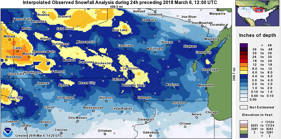 24-hr Snowfall Analysis (March 5-6) |
Peak Wind Gusts:
Here are the peak wind gusts from Monday, March 5th. Rochester International Airport (RST) had a gust to 52 kts and 51 kts around Midday.
Public Information Statement
National Weather Service La Crosse WI
942 AM CST Tue Mar 6 2018

...Peak Wind Reports from March 5th...

Location                     Speed     Time/Date

...Iowa...

...Chickasaw County...
2 N Ionia                    37 MPH    0850 AM 03/05

...Fayette County...
Oelwein Municipal Airport    49 MPH    1215 PM 03/05

...Howard County...
3 NE Riceville               42 MPH    1109 AM 03/05

...Winneshiek County...
Decorah Municipal Airport    43 MPH    1255 PM 03/05

...Minnesota...

...Dodge County...
Dodge Center Airport         48 MPH    1235 PM 03/05
2 E Kasson                   48 MPH    1240 PM 03/05

...Fillmore County...
2 ESE Canton                 45 MPH    0145 PM 03/05
Preston Airport              45 MPH    1155 AM 03/05

...Mower County...
1 ENE Dexter                 48 MPH    1120 AM 03/05
Austin Municipal Airport     45 MPH    1155 AM 03/05

...Olmsted County...
Rochester Intl Airport       60 MPH    1153 AM 03/05
Rochester Intl Airport       59 MPH    0125 PM 03/05
3 N Stewartville             54 MPH    0130 PM 03/05
2 SE Douglas                 53 MPH    1202 PM 03/05
2 SE Eyota                   50 MPH    0145 PM 03/05
Mayo Helipad                 47 MPH    0215 PM 03/05

...Wabasha County...
1 SSE Kellogg                35 MPH    0105 PM 03/05
Lake City                    34 MPH    1249 PM 03/05

...Winona County...
Winona Municipal Airport     43 MPH    0115 PM 03/05
1 E Ridgeway                 40 MPH    0400 PM 03/05

...Wisconsin...

...Crawford County...
Prairie Du Chien  Airport    41 MPH    1135 AM 03/05

...Grant County...
Platteville Municipal Airpor 49 MPH    0255 PM 03/05
Boscobel Airport             35 MPH    1129 AM 03/05
1 ENE Boscobel               32 MPH    0403 PM 03/05

...Jackson County...
Black River Falls Area Airpo 35 MPH    1235 PM 03/05
1 E Black River Falls        32 MPH    1115 AM 03/05

...Juneau County...
Volk Field                   44 MPH    0325 PM 03/05
Mauston                      40 MPH    0537 PM 03/05
Necedah                      33 MPH    0648 PM 03/05
Mauston Airport              33 MPH    0315 PM 03/05

...La Crosse County...
La Crosse Regional Airport   46 MPH    0156 PM 03/05
3 W Saint Joseph             42 MPH    1232 PM 03/05

...Monroe County...
Sparta/Fort McCoy Airport    41 MPH    0455 PM 03/05
2 E Cataract                 33 MPH    0518 PM 03/05

...Taylor County...
Chelsea                      34 MPH    0255 PM 03/05
Medford Airport              32 MPH    0515 PM 03/05
3 NE Lublin                  31 MPH    0114 PM 03/05

Observations are collected from a variety of sources with varying
equipment and exposures. We thank all volunteer weather observers
for their dedication. Not all data listed are considered official.
Snow Amounts:
Public Information Statement
National Weather Service La Crosse WI
1050 AM CST Tue Mar 6 2018

...24 Hour Snowfall Totals...

Location                     Amount    Time/Date

...IOWA...

...Allamakee County...
Waukon                       6.0 in    0640 AM 03/06
3 W Elon                     5.3 in    1005 PM 03/05
Harpers Ferry                4.0 in    0640 AM 03/05

...Chickasaw County...
New Hampton                  4.0 in    0700 AM 03/06
2 W Ionia                    3.5 in    0700 AM 03/06

...Clayton County...
Elkader 6SSW                 5.4 in    0700 AM 03/06
Clayton Center               5.0 in    0639 AM 03/06
Monona WWTP                  4.9 in    0700 AM 03/06
Strawberry Point             4.4 in    0700 AM 03/06
Edgewood                     3.5 in    0532 AM 03/06

...Fayette County...
Fayette                      4.7 in    0700 AM 03/06
Oelwein                      3.0 in    0800 AM 03/06

...Floyd County...
Nora Springs 2.4 SSE         4.0 in    0700 AM 03/06
Charles City                 3.8 in    0700 AM 03/06
2 SW Nashua                  3.3 in    0700 AM 03/06

...Howard County...
Elma                         4.4 in    0800 AM 03/06
Cresco 1NE                   4.0 in    0800 AM 03/06

...Mitchell County...
St Ansgar                    5.4 in    0630 AM 03/06
Riceville                    5.0 in    0800 AM 03/06
Osage                        3.8 in    0700 AM 03/06

...Winneshiek County...
5 ESE Decorah                4.9 in    0700 AM 03/06
7 ENE Decorah                4.0 in    0800 AM 03/06
Calmar NE                    3.6 in    0700 AM 03/06

...MINNESOTA...

...Dodge County...
2 NE Kasson                  7.8 in    0700 AM 03/06

...Fillmore County...
Harmony                      7.3 in    0439 AM 03/06
Rushford                     7.0 in    0800 AM 03/06
Peterson 1S                  6.5 in    0800 AM 03/06
Preston                      6.0 in    1110 PM 03/05
Pilot Mound 1SSE             5.5 in    0700 AM 03/06
Lanesboro 2NE                5.2 in    0700 AM 03/06
1 W Fillmore                 4.0 in    0700 AM 03/06
Mabel                        3.9 in    0700 AM 03/06
Spring Valley 3E             3.9 in    0700 AM 03/06
Spring Valley 1W             3.5 in    0905 AM 03/06

...Houston County...
Mound Prairie                7.2 in    0725 AM 03/06
1 NNW La Crescent            6.5 in    0700 AM 03/06
4 NW Eitzen                  6.0 in    0800 AM 03/06
Caledonia                    5.2 in    0700 AM 03/06
La Crescent                  5.0 in    0730 AM 03/06

...Mower County...
Austin Waste Water Treatment 4.5 in    0700 AM 03/06

...Olmsted County...
2 SSW Predmore               8.1 in    0430 AM 03/06
Byron                        7.6 in    0800 AM 03/06
4 ESE Douglas                7.5 in    0715 AM 03/06
3 NNW Chester                7.3 in    0907 PM 03/05
1 SSW Ornoco                 7.0 in    0708 AM 03/06
2 NW Rochester               7.0 in    0800 AM 03/06
Byron 4N                     6.8 in    0700 AM 03/06
Rochester Intl Airport       6.6 in    0554 AM 03/06
Stewartville 5N              6.3 in    1200 AM 03/06
Elgin 2SSW                   6.1 in    0700 AM 03/06
Elba 4.7 SW                  3.0 in    0700 AM 03/06

...Wabasha County...
Theilman 1SSW                8.2 in    0730 AM 03/06
3 NW Wabasha                 8.1 in    0700 AM 03/06
1 N Wabasha                  8.0 in    0555 AM 03/06
Wabasha                      5.8 in    0700 AM 03/06
Millville                    5.5 in    1022 PM 03/05

...Winona County...
Goodview                     8.0 in    0945 AM 03/06
4 N Saint Charles            7.5 in    0824 AM 03/06
Altura 5w                    7.0 in    0700 AM 03/06
Winona                       7.0 in    0700 AM 03/06
Winona 4SW                   7.0 in    0700 AM 03/06
Winona Dam 5                 5.0 in    0600 AM 03/06
Minnesota City Dam 5         4.0 in    0700 AM 03/06
La Crescent Dam 7            3.6 in    0600 AM 03/06

...WISCONSIN...

...Adams County...
Friendship                   4.6 in    0800 AM 03/06
1 SSW Grand Marsh            4.3 in    0700 AM 03/06

...Buffalo County...
Alma Dam 4                   6.0 in    0600 AM 03/06

...Clark County...
Chili 7N                     5.0 in    0651 AM 03/06
Owen 6SSE                    4.5 in    0700 AM 03/06
Neillsville 3NE              3.5 in    0800 AM 03/06

...Crawford County...
De Soto 1SE                  7.0 in    0600 AM 03/06
Steuben 4SE                  5.0 in    0650 AM 03/06
Prairie Du Chien             4.9 in    0700 AM 03/06
1 WNW Mount Zion             4.5 in    0700 AM 03/06

...Grant County...
Woodman                      5.5 in    1000 AM 03/06
Sinsinawa                    4.0 in    0700 AM 03/06
Cuba City                    3.0 in    0800 AM 03/06

...Jackson County...
Black River Falls            4.0 in    0800 AM 03/06
Hatfield                     4.0 in    0800 AM 03/06
Black River Falls 1.7 NNE    3.9 in    0700 AM 03/06

...Juneau County...
Union Center                 5.0 in    0700 AM 03/06
Mauston 1se                  5.0 in    0800 AM 03/06

...La Crosse County...
West Salem                   8.3 in    0700 AM 03/06
Onalaska 2S                  7.5 in    0130 AM 03/06
3 W Saint Joseph             7.2 in    1052 PM 03/05
La Crosse 4SE                6.7 in    0830 PM 03/05
Holmen                       6.5 in    0945 PM 03/05
Holmen 2S                    6.3 in    0700 AM 03/06
French Island                6.3 in    0700 AM 03/06
La Crosse Regional Airport   6.1 in    0553 AM 03/06
La Crosse Weather Office     6.0 in    0600 AM 03/06

...Monroe County...
Cashton 3NNW                 6.7 in    0739 AM 03/06
Melvina                      6.5 in    0700 AM 03/06
Tomah                        6.0 in    0726 AM 03/06
Warrens 4WSW                 5.6 in    0700 AM 03/06
Four Corners                 3.6 in    0700 AM 03/06

...Richland County...
Ithaca                       5.0 in    0557 AM 03/06

...Taylor County...
Medford                      7.0 in    0249 AM 03/06

...Trempealeau County...
3 N Arcadia                  8.5 in    0710 AM 03/06
Arcadia                      8.0 in    0700 AM 03/06
Ettrick 4WNW                 7.3 in    0555 AM 03/06
Trempealeau Dam 6            6.0 in    0600 AM 03/06
Galesville 2WSW              6.0 in    0838 PM 03/06
Whitehall 2W                 5.0 in    0830 AM 03/06

...Vernon County...
De Soto                      7.0 in    0615 AM 03/06
Hillsboro WSW                6.5 in    0700 AM 03/06
La Farge                     6.5 in    0800 AM 03/06
3 WNW Viola                  5.7 in    0800 AM 03/06
Stoddard 5NNE                5.2 in    0700 AM 03/06
Stoddard 2NE                 5.2 in    0630 AM 03/06
Viroqua                      5.0 in    0700 AM 03/06
Stoddard                     4.6 in    0700 AM 03/06
Westby 3ENE                  4.5 in    0700 AM 03/06
Hillsboro 2SW                4.2 in    0700 AM 03/06
Genoa Dam 8                  4.0 in    0600 AM 03/06

Observations are collected from a variety of sources with varying
equipment and exposures. We thank all volunteer weather observers
for their dedication. Not all data listed are considered official.
Photos:
Header
 |
 |
||
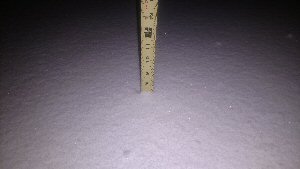
| Snow depth at St.Joseph Ridge (Photo by Dave Lawrence/NWS) |
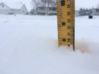
Snowfall in Byron, MN (Photo by Chris Kuball/KAAL) |
Freezing Rain / Icing Reports:
PRELIMINARY LOCAL STORM REPORT
NATIONAL WEATHER SERVICE LA CROSSE WI
1104 AM CST TUE MAR 6 2018

..TIME...   ...EVENT...      ...CITY LOCATION...     ...LAT.LON...
..DATE...   ....MAG....      ..COUNTY LOCATION..ST.. ...SOURCE....
            ..REMARKS..

0143 PM     FREEZING RAIN    OELWEIN                 42.68N 91.91W
03/05/2018  M0.00 INCH       FAYETTE            IA   PUBLIC

            VIA BROADCAST MEDIA FREEZING RAIN AND GLAZE
            COVERING EVERYTHING.

0123 PM     FREEZING RAIN    STRAWBERRY POINT        42.69N 91.53W
03/05/2018  M0.00 INCH       CLAYTON            IA   CO-OP OBSERVER

            COOPERATIVE OBSERVER REPORTS FREEZING RAIN
            AND SLEET. LIGHT GLAZING OF ICE ON OBJECTS
            ALOFT.

0112 PM     FREEZING RAIN    NEW HAMPTON             43.06N 92.32W
03/05/2018  E0.00 INCH       CHICKASAW          IA   EMERGENCY MNGR

            LIGHT GLAZING.

0552 AM     SLEET            2 NNW FAYETTE           42.87N 91.82W
03/05/2018  M0.1 INCH        FAYETTE            IA   AMATEUR RADIO

            WIND GUSTS 38 MPH. MIXED PRECIPITATION OF
            FREEZING RAIN AND SLEET. GLAZING OF ICE.

0552 AM     SLEET            2 NNW FAYETTE           42.87N 91.82W
03/05/2018  M0.6 INCH        FAYETTE            IA   PUBLIC

            WIND GUSTS 38 MPH. MIXED PRECIPITATION OF
            FREEZING RAIN AND SLEET. GLAZING OF ICE.
 |
Media use of NWS Web News Stories is encouraged! Please acknowledge the NWS as the source of any news information accessed from this site. |
|


 Weather Story
 Weather Map
 Local Radar