Houston/Galveston, TX
Weather Forecast Office
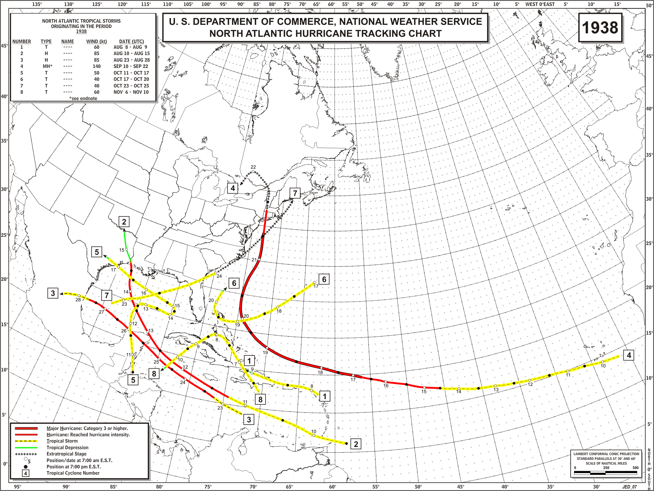
HURRICANE (Cat. 1 - August 14th landfall)
This hurricane struck just east of the TX-LA border. At Lake Jackson, LA, one man was killed, another injured, and scores suffered "a night of terror" as the hurricane roared over the city. Along the upper TX coast, a high tide was the only effect.
TROPICAL STORM (October 17th landfall)
This tropical storm wandered around the Gulf for several days before making landfall near Freeport and producing squally weather.
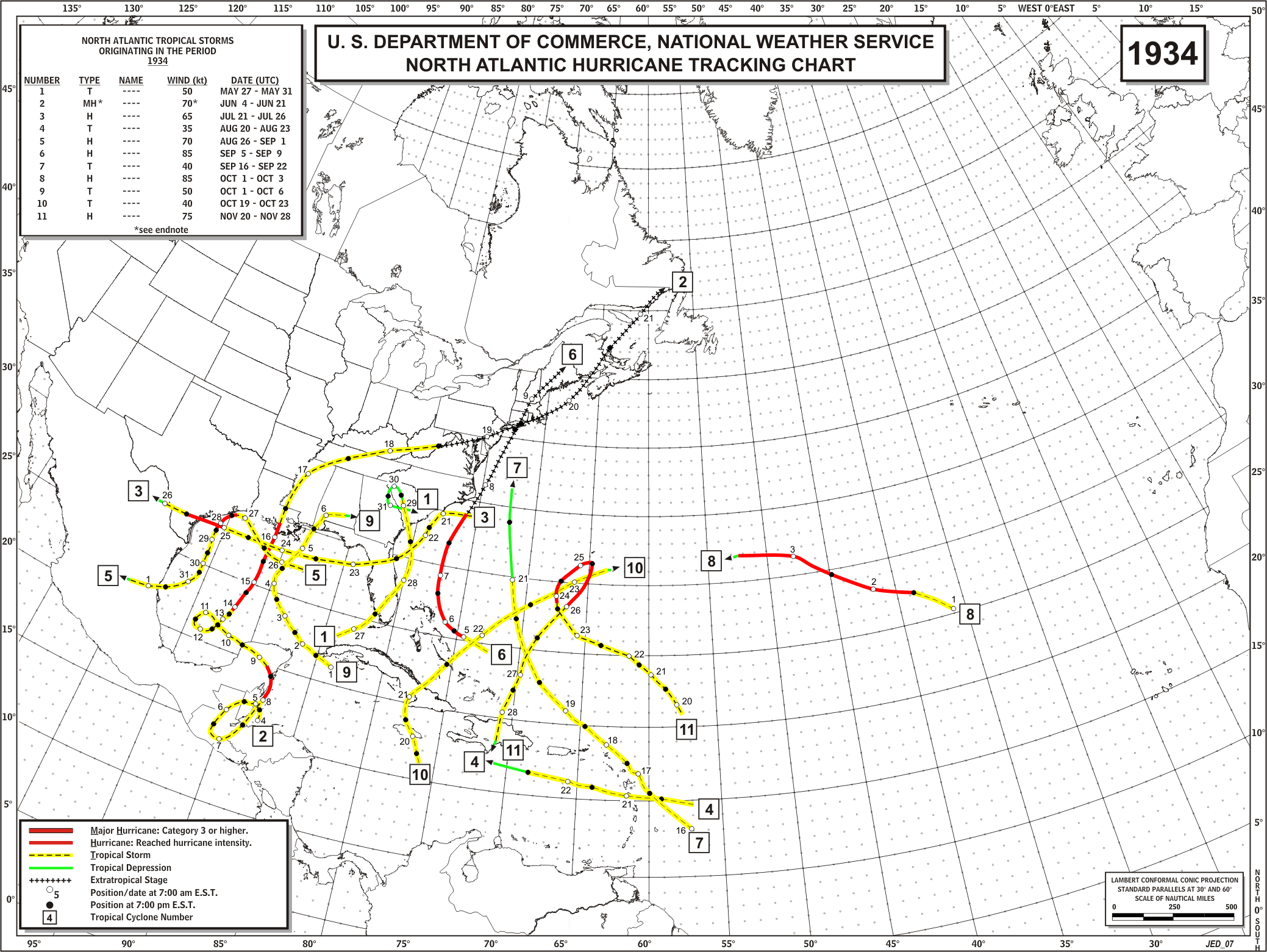
HURRICANE (Cat. 1* - July 25th landfall)
An unusual storm which formed off the Carolina coast in the Atlantic, moved south and west across FL and into the Gulf. South of LA, the storm developed rapidly into a hurricane and moved westward toward its landfall at Rockport. Winds in Corpus Christi gusted to 56 mph, the barometer fell to 29.12" (28.79" at Rockport), and a 10.2' storm surge was recorded on St. Joseph's Island. Up to 19 deaths and many injuries were attributed to the hurricane in TX.
* - Hurrtrak data indicated a Category 1 status; NHC/TPC documents had peak at a Category 2.
HURRICANE (Cat. 1 - August 27th landfall)
This system started in the Gulf below Alabama, moved toward Galveston, and "buzzed" the island on the 27th, then turned southwest and moved down the coast until finally making landfall near Tampico, Mexico. On the Texas coast, high tides and small amounts of rainfall were the only impact.
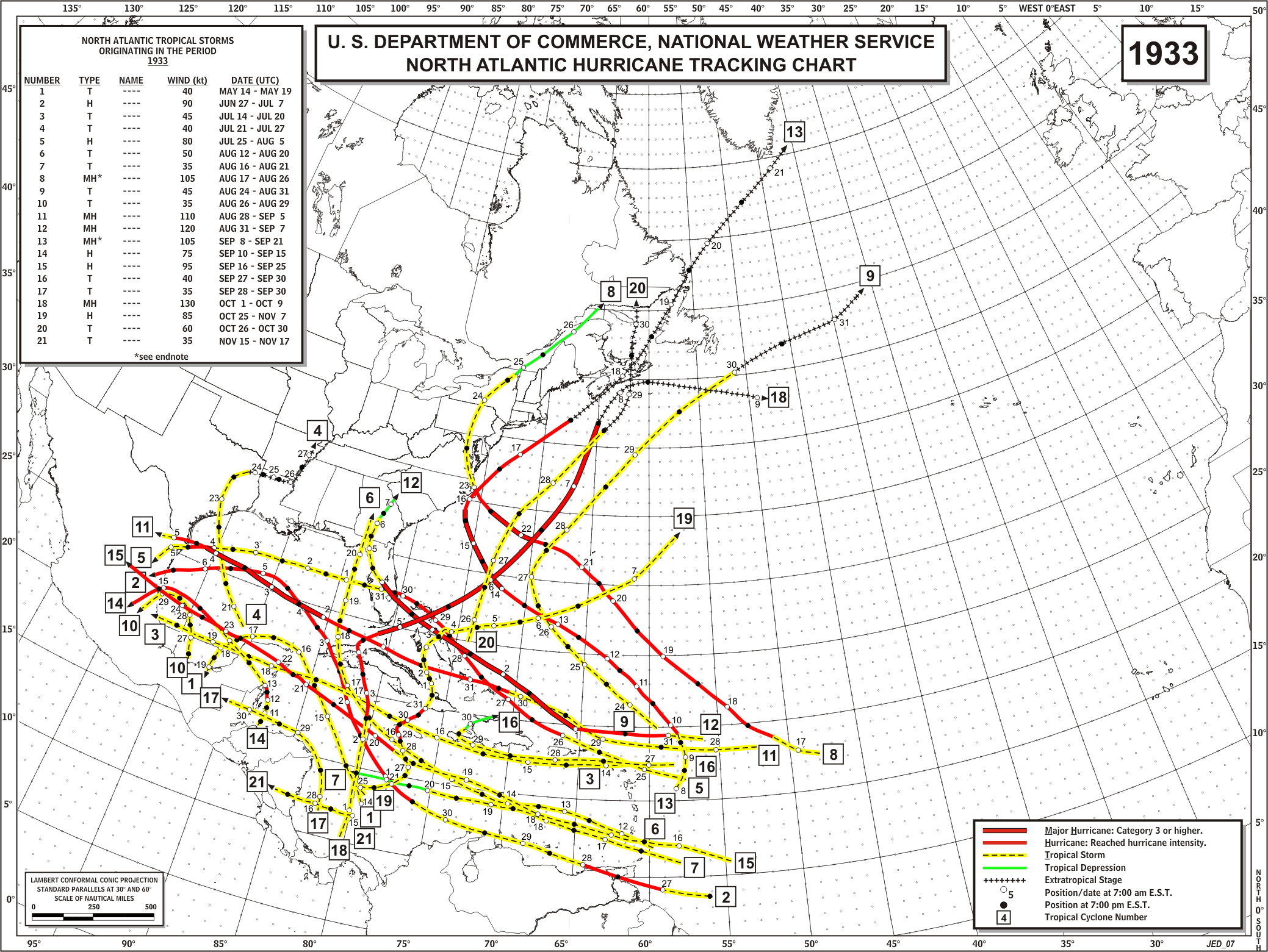
The 1933 Hurricane Season was notable in two respects. First, the 21 tropical disturbances recorded that year was a record in the Atlantic, and second, the majority of storms moved farther west than is usual. Seven of these made landfall between Corpus Christi and Tampico, Mexico.
TROPICAL STORM (July 23rd landfall)
This storm was considered one of the greatest tropical storms in area and general rainfall. The storm reached the Freeport area on 7/22 and moved very slowly for the next three days into LA. Rainfall averaged 12.50" over an area of 25,000 square miles. Twenty inches fell in a small area of east TX and western LA. Logansport, LA recorded 22.30" over a four day period.
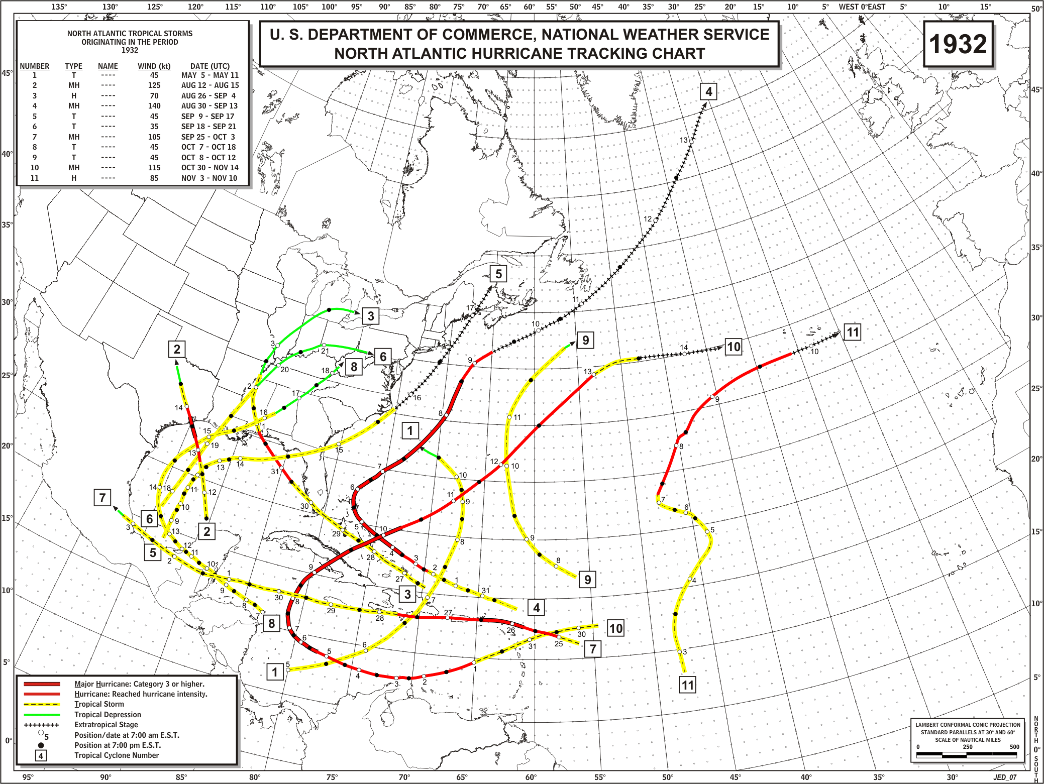
HURRICANE (Cat. 4 - August 14th landfall)
This intense hurricane of small diameter struck between Galveston and Freeport. Highest winds were estimated at 100 mph which blew down flimsy shacks and left 600 families homeless. The system brought 12" of rain to OK later. Forty lives were lost, and 200 persons were injured. Eight hundred birds at Wharton were killed by the driving rain.
Statistics:
Winds (mph): East Columbia - estimated 100; Houston - 65.
Pressure (inches): on a ship offshore - 27.82; East Columbia - 27.83; Freeport - 28.03.
CURRENT HAZARDS
-National Hurricane Center
-Storm Prediction Center
-Weather Prediction Center
-River Forecast Centers
-Aviation Weather Center
-Center Weather Service Units
-Spaceflight Meteorology Group
-Space Weather Prediction Center
CURRENT WEATHER
-Tides and Currents
-Observations
-Satellite
-Rainfall Reports
-Public Information Statement
-Galveston Beach Patrol (Flag Warning System)
FORECASTS
-Activity Planner
-Forecast Discussion
-Marine
-Tropical
-Aviation
-Fire
-Beach
-Models
-Drought
History
-Our Office
-National Weather Service
-NOAA
-Major Events
RADAR
-Houston/Galveston
-National
-Corpus Christi
-Lake Charles
-Austin/San Antonio
-Granger (Central Texas)
-Worldwide
-Education
Rivers/Lakes/Bayous
-Lower Colorado River Authority
-Harris County Flood Warning System
-Local
-National
-Jefferson County Drainage District 6
-Brazos River Authority
CLIMATE
-Houston Intercontinental
-Houston Hobby
-Galveston
-College Station
-Palacios
-Graphs
-Climate Summaries
-Local Data/Records
-Old Climate Page
-NCEI
-Storm Data
-Weather History
-Wind Roses
Education/Careers
-National Weather Service
-Careers
-Web Weather for Kids
-HGX Teacher Resources
-more
PREPAREDNESS/SAFETY
-Evacuation Planning
-Publications/Brochures
-StormReady
-2026 Hurricane Guide
-2026 Hurricane Guide (Spanish)
-SKYWARN Schedule
-FloodAware
-Weather Radio
-Evacuation ZipZone
-Evacuation Routes
-more
ADDITIONAL INFO
-Weather Ready Nation
-Weather Safety
-Severe Stats
-Air Now
-CoCoRaHS
-Miscellaneous Info
-Astronomical Info
-Frequent Products
-Find It Quick
-Watch, Warning, and Advisory Criteria
Tropical
-Preparedness Meetings
-Historical Tracks
-Education
-Climatology for SE TX
-Hurricane Harvey
-Hurricane Alicia
-Tropical Storm Imelda
-Local Page
US Dept of Commerce
National Oceanic and Atmospheric Administration
National Weather Service
Houston/Galveston, TX
1353 FM 646 Suite 202
Dickinson, TX 77539
281-337-5074
Comments? Questions? Please Contact Us.

