Wildfire smoke will push into the Midwest, worsening air quality. A frontal system brings severe storms from the Northern Plains to the Mid‑Atlantic the next few days. Heavy Gulf Coast rain is possible as Tropical Depression Two has formed, while monsoonal storms persist in the Southwest with heavy rainfall. Hazardous heat expands from the Plains into the Lower Mississippi Valley. Read More >
|
|
Other Recaps: National Northwest IL Central IL Southwest IL Northern IN Central IN
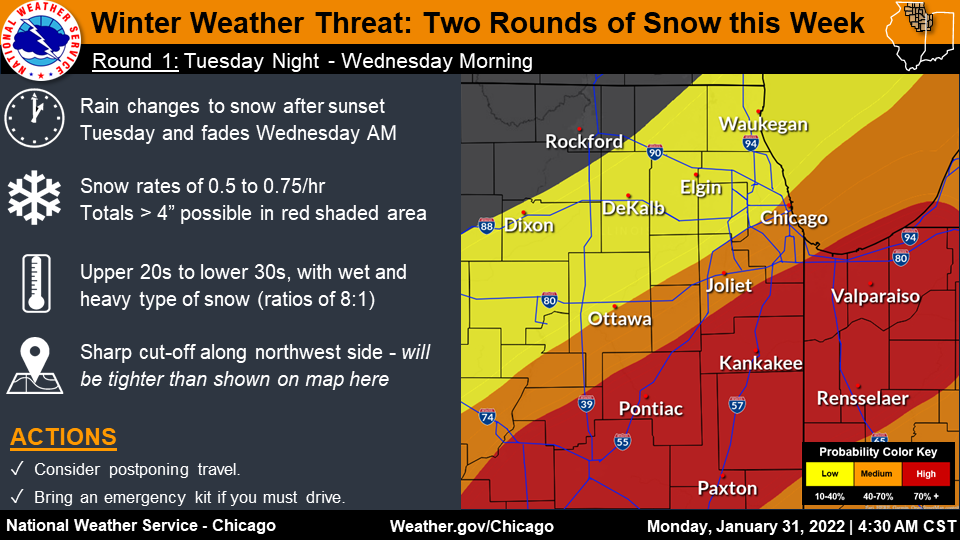
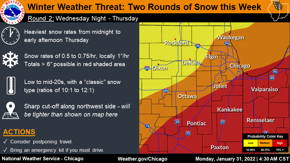
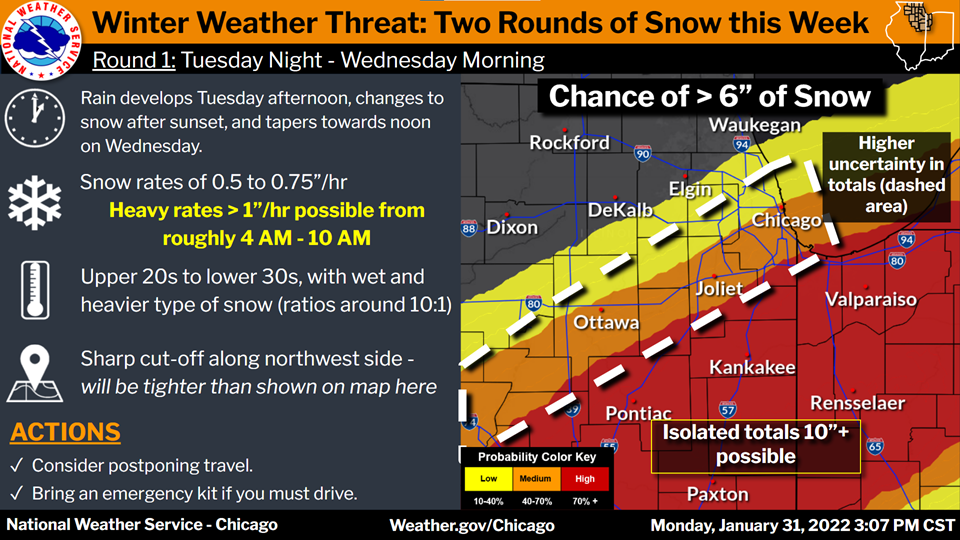
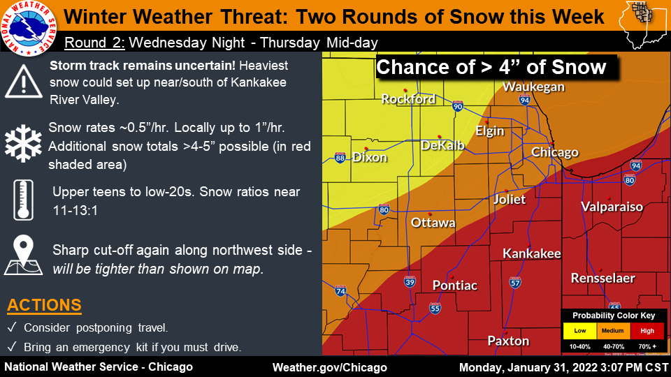
Fast Facts
Snow Totals
|
|
|
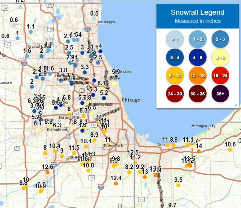 |
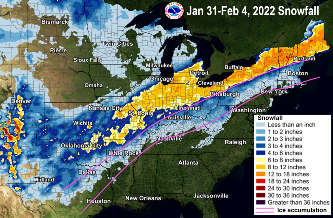
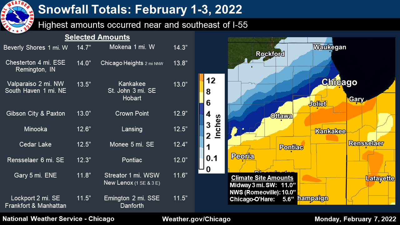
| Snowfall and ice area from Jan 31-Feb 4, most from the same winter system impacting the local area. | Preliminary forecast area observed snowfall map from Feb 1-3. | Preliminary Chicago metro observed snowfall observations from Feb 1-3. |
Public Information Statement National Weather Service Chicago IL 940 PM CST Sun Feb 6 2022 Final Snow Totals from the 2/1/2022-2/3/2022 Winter Storm Location Amount Time/Date Provider Illinois Cook County Chicago Heights 2 NNW 13.8 in 0900 AM 02/03 COCORAHS Lansing 12.5 in 0700 AM 02/03 COOP Burr Ridge 1 ENE 11.2 in 0700 AM 02/03 COCORAHS Bridgeview 1 NNW 11.0 in 0730 AM 02/03 COCORAHS Homewood 11.0 in 0600 PM 02/02 Public Midway 3 SW 11.0 in 0600 AM 02/03 COOP Oak Forest 1 N 11.0 in 0700 AM 02/03 COCORAHS Oak Lawn 11.0 in 0430 PM 02/02 Trained Spotter Oak Lawn 0.5 SSW 11.0 in 0700 AM 02/03 COCORAHS Midlothian 10.8 in 0338 PM 02/02 Trained Spotter Homewood 10.7 in 0455 PM 02/02 Cocorahs Tinley Park 10.5 in 0304 PM 02/02 Public Oak Lawn 2 WNW 10.1 in 0800 AM 02/03 COCORAHS Chicago Ridge 10.0 in 0700 AM 02/03 COCORAHS Hickory Hills 10.0 in 0600 PM 02/02 Public Oak Lawn 1 WSW 9.8 in 0745 AM 02/03 COCORAHS Park Forest 9.8 in 0500 AM 02/03 COOP Park Forest 1 WNW 9.5 in 0730 AM 02/03 COCORAHS Lakeview - Chicago 9.0 in 0530 PM 02/02 Public Oak Park 9.0 in 0251 PM 02/02 Public Palos Park 1 SW 8.9 in 0700 AM 02/03 COCORAHS La Grange 8.5 in 0800 AM 02/03 COCORAHS 1 SE Logan Square - Chicago 8.4 in 0305 PM 02/02 Public Oak Park 1 NNE 8.3 in 0700 AM 02/03 COCORAHS Lincolnwood 2 E 7.8 in 0700 AM 02/03 COCORAHS 1 N Douglas - Chicago 7.8 in 0230 PM 02/02 NWS Employee Humboldt Park - Chicago 7.8 in 0350 PM 02/02 Public Lakeview - Chicago 7.8 in 0500 PM 02/02 Public Rogers Park 2 SW 7.1 in 0700 AM 02/03 COCORAHS 1 E Logan Square - Chicago 7.0 in 0125 PM 02/02 Public Portage Park - Chicago 7.0 in 0530 PM 02/02 Public Chicago 5.5 NNW 6.7 in 0700 AM 02/03 COCORAHS La Grange Park 1 SSW 6.5 in 0700 AM 02/03 COCORAHS South Shore - Chicago 6.4 in 0430 PM 02/02 Public Jefferson Park - Chicago 6.3 in 0300 PM 02/02 Trained Spotter Harwood Heights 6.1 in 0700 AM 02/03 COCORAHS Evanston 1 ESE 5.9 in 0800 AM 02/03 COCORAHS Harwood Heights 5.7 in 0400 PM 02/02 Trained Spotter Ohare Airport 5.6 in 0400 PM 02/02 Official NWS Obs Franklin Park 0.5 SSE 5.3 in 0800 AM 02/03 COCORAHS Oak Park 1 NNE 5.2 in 0655 AM 02/03 COCORAHS 1 NNE Evanston 5.0 in 0520 PM 02/02 Public Niles 5.0 in 0347 PM 02/02 Public 1 WNW Arlington Heights 4.4 in 0130 PM 02/02 Public Mount Prospect 3 NE 4.3 in 0700 AM 02/04 COCORAHS Park Ridge 1 WNW 4.2 in 0700 AM 02/04 COCORAHS 1 SW Des Plaines 4.2 in 0430 PM 02/02 Public 1 NE Roselle 4.1 in 1230 PM 02/02 Public Elk Grove Village 2 WSW 4.0 in 0700 AM 02/04 COCORAHS 2.0 W Schaumburg 3.9 in 0225 PM 02/02 NWS Employee Hoffman Estates 1 ESE 3.9 in 0700 AM 02/03 COCORAHS Hoffman Estates 2 SE 3.8 in 0700 AM 02/03 COCORAHS Elk Grove Village 1 ESE 3.6 in 0700 AM 02/04 COCORAHS Schaumburg 1 SE 3.6 in 0700 AM 02/04 COCORAHS 1 NE Palatine 3.4 in 0550 PM 02/02 NWS Employee Schaumburg 3 WSW 3.5 in 0700 AM 02/04 COCORAHS Mount Prospect 3.3 in 0630 AM 02/03 COCORAHS Palatine 1 NW 2.9 in 0700 AM 02/03 COCORAHS Palatine 1 E 2.1 in 0840 AM 02/03 COCORAHS Palatine 1 NNE 2.1 in 0700 AM 02/03 COCORAHS Hoffman Estates 5 W 1.6 in 0915 AM 02/03 COCORAHS De Kalb County Hinckley 5.5 in 0600 PM 02/02 Public De Kalb 3.5 WSW 2.6 in 0700 AM 02/03 COCORAHS Sycamore 2.5 in 0600 PM 02/02 Public Cortland 2.3 in 0600 AM 02/03 COCORAHS DeKalb 2.3 in 0700 AM 02/03 COOP DeKalb 1 SW 2.2 in 0700 AM 02/03 COCORAHS DeKalb 2.0 in 0315 PM 02/02 Trained Spotter Genoa 2.0 in 0600 PM 02/02 Public Genoa 1.5 in 0700 AM 02/03 COOP DuPage County Burr Ridge 10.0 in 0600 PM 02/02 Public 1 NW Westmont 9.0 in 0300 PM 02/02 Public Downers Grove 2 S 8.8 in 0330 PM 02/02 NWS Employee Burr Ridge 2 SW 8.3 in 0700 AM 02/03 COCORAHS Clarendon Hills 8.3 in 0700 AM 02/03 UCOOP Darien 2 SE 8.3 in 0745 AM 02/03 COCORAHS Morton Arboretum 8.3 in 0700 AM 02/04 COOP Naperville 2 SE 8.0 in 0700 AM 02/03 COCORAHS Bolingbrook 3 NE 7.8 in 0700 AM 02/03 COCORAHS Elmhurst 2 SE 7.8 in 0700 AM 02/03 COCORAHS 3 SSE Naperville 7.8 in 0400 PM 02/02 NWS Employee 1 NE Naperville 7.7 in 0301 PM 02/02 Public Willowbrook 7.0 in 1245 PM 02/02 Public Glen Ellyn 4 S 7.0 in 0300 PM 02/02 UCOOP 4 SE Aurora 6.9 in 0410 PM 02/02 Trained Spotter Lisle 1 SE 6.9 in 0700 AM 02/04 COCORAHS Glen Ellyn 1 W 6.8 in 0700 AM 02/03 COCORAHS Naperville 6.8 in 1258 PM 02/02 Public Wheaton 2 NNE 6.8 in 0700 AM 02/03 COCORAHS Aurora 4 SE 6.6 in 0700 AM 02/03 COCORAHS 2 ESE Warrenville 6.5 in 0400 PM 02/02 Trained Spotter Lombard 6.0 in 1200 PM 02/02 Trained Spotter Wheaton 1 NNW 5.9 in 0700 AM 02/03 COCORAHS Aurora 3.6 SE 5.8 in 0700 AM 02/03 COCORAHS Villa Park 1 ESE 5.6 in 0700 AM 02/03 COCORAHS West Chicago 3.5 SE 5.5 in 0720 AM 02/03 COCORAHS Winfield 1 ENE 4.8 in 0800 AM 02/03 COCORAHS Ford County Gibson City 13.0 in 0900 AM 02/04 Public Paxton 13.0 in 0900 AM 02/04 Public Grundy County Minooka 12.6 in 0800 AM 02/03 COCORAHS Morris 11.0 in 0600 PM 02/02 Public Morris 6 ESE 10.9 in 0700 AM 02/03 COCORAHS Braceville 10.5 in 0600 PM 02/02 Public Coal City 10.5 in 0115 PM 02/02 Public Morris 1 NW 10.0 in 0800 AM 02/03 COOP Coal City 9.8 in 0800 AM 02/03 COCORAHS Coal City 4 NNW 9.8 in 0700 AM 02/03 UCOOP Mazon 9.7 in 0600 PM 02/02 Public Mazon 2 SE 9.0 in 0700 AM 02/03 COCORAHS Morris 1.5 SW 8.8 in 0700 AM 02/03 COCORAHS Iroquois County Danforth 11.5 in 0900 AM 02/04 COCORAHS Milford 3.5 ENE 10.0 in 0700 AM 02/04 COCORAHS Ashkum 6 E 9.0 in 0800 AM 02/04 COCORAHS Watseka 9.0 in 0600 PM 02/02 Public Kane County Geneva 4 WSW 6.3 in 0400 AM 02/03 COCORAHS Aurora 2.8 WSW 5.7 in 0700 AM 02/03 COCORAHS North Aurora 1.5 NE 5.3 in 0700 AM 02/03 COCORAHS Aurora 3 WSW 5.2 in 0700 AM 02/03 COCORAHS Aurora 5.0 in 0700 AM 02/03 COOP Batavia 5.0 in 0300 PM 02/02 Public North Aurora 5.0 in 0500 PM 02/02 Public Geneva 1.3 SSW 4.6 in 0730 AM 02/03 COCORAHS Elburn 4.5 in 0700 AM 02/03 COCORAHS Batavia 4.3 in 0600 AM 02/03 UCOOP Batavia 1.5 WNW 4.3 in 0700 AM 02/03 COCORAHS St. Charles 4.0 in 1200 PM 02/02 Broadcast Media St. Charles 4.0 in 0800 AM 02/03 COCORAHS Batavia 3.9 in 0630 AM 02/03 COCORAHS Batavia 3 WSW 3.9 in 0630 AM 02/03 COCORAHS Geneva 1 SSW 3.8 in 0700 AM 02/03 COCORAHS Batavia 1 W 3.5 in 0727 AM 02/03 COCORAHS South Elgin 3.5 in 0600 PM 02/02 Public Geneva 1 NW 3.4 in 0700 AM 02/03 COCORAHS Pingree Grove 3.0 in 0600 PM 02/02 Public Elgin 2.9 in 0800 AM 02/03 UCOOP Elgin 1 S 2.9 in 0800 AM 02/03 COCORAHS Maple Park 2.5 in 0530 PM 02/02 COCORAHS Elgin 2.5 W 2.1 in 0700 AM 02/03 COCORAHS St Charles 6 NW 2.0 in 0700 AM 02/03 COCORAHS Elgin 1.8 in 0700 AM 02/03 COOP Kankakee County Kankakee 13.0 in 0700 AM 02/03 COOP Kankakee 1 WSW 11.8 in 0600 AM 02/04 COCORAHS Kankakee 11.2 in 0600 PM 02/02 Public Bradley 11.0 in 0600 PM 02/02 Public Herscher 11.0 in 0600 PM 02/02 Public Bourbonnais 10.7 in 0700 AM 02/03 COOP Grant Park 10.5 in 0600 PM 02/02 Public Manteno 10.0 in 0600 PM 02/02 Public St. Anne 9.1 in 0700 AM 02/03 COOP Kendall County Oswego 5 SSE 8.8 in 0700 AM 02/03 COCORAHS Oswego 2 SSW 8.5 in 0700 AM 02/03 COCORAHS Plainfield 5 SW 8.0 in 0700 AM 02/03 COCORAHS Millbrook 7.3 in 0141 PM 02/02 Trained Spotter Montgomery 1 SSE 6.1 in 0700 AM 02/03 COCORAHS La Salle County Streator 1 WSW 11.6 in 0700 AM 02/03 COCORAHS Streator 10.0 in 0700 AM 02/03 COOP Streator 9.5 in 0600 PM 02/02 Public Marseilles 8.0 in 0641 AM 02/02 Public Peru 1 ENE 8.0 in 0700 AM 02/03 COCORAHS Ottawa 2 N 7.0 in 0700 AM 02/03 COCORAHS Marseilles 3 WSW 6.7 in 0800 AM 02/03 COCORAHS La Salle 6.5 in 0700 AM 02/03 COCORAHS Ottawa 1 NW 6.3 in 0514 AM 02/03 COCORAHS Utica 6.3 in 0230 PM 02/02 Public Lake County Highwood 1 S 4.5 in 0700 AM 02/04 COCORAHS Lake Forest 2 NNE 4.1 in 0800 AM 02/04 COCORAHS 1 SSW Deerfield 3.8 in 0144 PM 02/02 Public Bannockburn 0.5 ESE 3.1 in 0700 AM 02/03 COCORAHS Buffalo Grove 1.5 N 3.0 in 0700 AM 02/03 COCORAHS Forest Lake 1 SSW 2.5 in 0700 AM 02/03 UCOOP Riverwoods 2.5 in 0700 AM 02/03 COCORAHS Lake Zurich 1 W 2.0 in 0600 AM 02/03 COCORAHS Mundelein 4 WSW 2.1 in 0700 AM 02/03 COOP Mundelein 0.5 NNE 1.5 in 0800 AM 02/04 COCORAHS Mundelein 2 WNW 1.5 in 0730 AM 02/03 COCORAHS Wadsworth 1 S 1.4 in 0900 AM 02/04 COCORAHS Gurnee 2 W 1.3 in 0700 AM 02/04 COCORAHS Antioch 1.0 in 0600 PM 02/02 Public Lake Villa 2 WSW 1.0 in 0730 AM 02/02 COCORAHS Long Lake 0.8 in 0700 AM 02/02 COCORAHS Waukegan 2 N 0.5 in 0800 AM 02/03 COCORAHS Lee County Sublette 3 WNW 3.5 in 0730 AM 02/02 COCORAHS Paw Paw 2 S 3.2 in 0700 AM 02/03 COOP Amboy 2.5 in 0700 AM 02/03 COOP Amboy 0.5 SSW 2.6 in 0525 AM 02/03 COCORAHS Steward 3 S 1.5 in 0700 AM 02/02 COOP Ashton 1.4 in 0700 AM 02/02 COCORAHS Sterling 4 NE 0.5 in 0800 AM 02/02 COCORAHS Livingston County Pontiac 12.0 in 0600 PM 02/02 Public Emington 2 SSE 11.5 in 0600 AM 02/03 COCORAHS Fairbury 11.0 in 0700 AM 02/03 COOP Fairbury 10.5 in 0600 PM 02/02 Public Chatsworth 10.0 in 0700 AM 02/03 COOP Dwight 10.0 in 0600 PM 02/02 Public Odell 10.0 in 0600 PM 02/02 Public McHenry County Algonquin 1 N 2.0 in 0545 AM 02/03 COCORAHS Cary 1.9 in 0700 AM 02/03 COCORAHS Cary 0.5 SSW 1.9 in 0700 AM 02/03 COCORAHS Trout Valley 1.9 in 0700 AM 02/03 COCORAHS Huntley 1.6 in 0700 AM 02/03 COCORAHS Bull Valley 2.5 WNW 1.1 in 0800 AM 02/02 COCORAHS McHenry 2 E 1.1 in 0900 AM 02/02 COCORAHS Woodstock 4 SW 1.0 in 0800 AM 02/03 COCORAHS Marengo 1 S 1.0 in 0700 AM 02/02 COCORAHS Marengo 1 NNW 0.6 in 0700 AM 02/02 COCORAHS Woodstock 5 NW 0.6 in 0700 AM 02/03 COOP Hebron 2 WSW 0.5 in 0700 AM 02/03 UCOOP Will County Mokena 1 W 14.3 in 0700 AM 02/03 COCORAHS Monee 5 SE 12.4 in 0800 AM 02/03 COCORAHS Mokena 2 WSW 11.6 in 0700 AM 02/03 COCORAHS New Lenox 1 SE 11.6 in 0600 AM 02/03 COCORAHS New Lenox 3 E 11.6 in 0700 AM 02/03 COCORAHS Frankfort 11.5 in 0600 PM 02/02 Public Lockport 1 SE 11.5 in 0700 AM 02/03 COCORAHS Manhattan 1 ESE 11.5 in 0900 AM 02/03 COCORAHS Braidwood 11.0 in 0245 PM 02/02 Emergency Mngr 1 W Crest Hill 11.0 in 0417 PM 02/02 Public Elwood 11.0 in 0510 PM 02/02 Public Crest Hill 10.8 in 0430 PM 02/02 Trained Spotter Joliet 10.8 in 0400 PM 02/02 Trained Spotter Manhattan 5 ENE 10.8 in 0800 AM 02/03 COOP Peotone 10.8 in 0700 AM 02/03 COOP Channahon 10.7 in 0600 PM 02/02 Public Homer Glen 1 NNE 10.4 in 0700 AM 02/03 COCORAHS Plainfield 2 SSE 10.4 in 0700 AM 02/03 COCORAHS New Lenox 2 ESE 10.3 in 0800 AM 02/03 COCORAHS NWS Chicago-Romeoville 10.0 in 0400 PM 02/02 Official NWS Obs Steger 10.0 in 0300 PM 02/02 Trained Spotter Wilmington 10.0 in 0600 PM 02/02 Public Joliet Brandon Road Lock 9.5 in 0600 AM 02/03 COOP Bolingbrook 1 SW 9.0 in 0954 AM 02/02 COCORAHS Joliet 2 N 9.0 in 0700 AM 02/03 UCOOP Plainfield 9.0 in 0110 PM 02/02 Public Naperville 4 SE 8.5 in 0600 PM 02/02 COCORAHS Naperville 3 SSW 8.3 in 0900 AM 02/03 COCORAHS Crete 3 E 8.2 in 0700 AM 02/03 COCORAHS 4 SSW Naperville 8.0 in 0322 PM 02/02 Trained Spotter 2 W Bolingbrook 7.8 in 0400 PM 02/02 Public 2 NW Plainfield 7.3 in 0356 PM 02/02 NWS Employee Naperville 4 SSW 6.3 in 0700 AM 02/03 COCORAHS Winnebago County Rockford Airport 0.1 in 0600 AM 02/02 Official NWS Obs Indiana Jasper County Remington 14.0 in 0800 AM 02/04 COCORAHS Rensselaer 6 SE 12.3 in 0700 AM 02/04 COCORAHS Rensselaer 2 SW 10.5 in 0730 AM 02/04 COOP Rensselaer 2 SSW 9.9 in 0600 AM 02/04 COCORAHS DeMotte 1 NNW 9.7 in 0600 AM 02/03 COCORAHS DeMotte 1 SSW 9.0 in 0800 AM 02/03 COCORAHS De Motte 6 S 8.0 in 0700 AM 02/03 COCORAHS DeMotte 4 SW 7.1 in 0700 AM 02/04 COCORAHS Lake County St. John 3 SE 13.0 in 0700 AM 02/03 COCORAHS Hobart 2 SE 13.0 in 0940 AM 02/03 COCORAHS Crown Point 12.9 in 0830 AM 02/03 COOP Crown Point 1 N 12.6 in 0830 AM 02/03 COCORAHS Cedar Lake 12.5 in 0420 PM 02/02 Trained Spotter Gary 5 ENE 11.8 in 0700 AM 02/03 COCORAHS 1 WNW Dyer 11.2 in 0600 PM 02/02 Cocorahs Dyer 11.2 in 0600 AM 02/03 COCORAHS Crown Point 11.0 in 0700 PM 02/02 Public Dyer 11.0 in 0100 PM 02/02 Public Lowell 11.0 in 0700 PM 02/02 Public Lowell 3 NNW 10.5 in 0800 AM 02/03 COCORAHS St. John 9.2 in 0700 AM 02/03 COCORAHS Newton County 5 N Morocco 11.0 in 0217 PM 02/02 Public Morocco 10.0 in 0600 AM 02/03 COOP Mount Ayr 2 NNE 7.4 in 0845 AM 02/03 COCORAHS Kentland 7.0 in 0250 PM 02/02 Trained Spotter Porter County Beverly Shores 1 W 14.7 in 0800 AM 02/03 COCORAHS Chesterton 4 ESE 14.0 in 0700 AM 02/03 COCORAHS 1 NE South Haven 13.5 in 0814 PM 02/02 Public Valparaiso 2 NW 13.5 in 1000 AM 02/03 COCORAHS Valparaiso 1 NNW 12.0 in 0700 AM 02/03 COCORAHS Valparaiso 2 WSW 11.5 in 0200 PM 02/03 COCORAHS Porter 1 S 11.1 in 0700 AM 02/03 COCORAHS Valparaiso 2 NW 10.6 in 0700 AM 02/03 COCORAHS Valparaiso 2 WNW 10.5 in 0700 AM 02/03 COCORAHS 3 NNW Valparaiso 10.4 in 0440 PM 02/02 Trained Spotter 1 ESE Valparaiso 10.0 in 1140 AM 02/02 Trained Spotter Portage 2 NNW 9.9 in 0530 AM 02/03 COCORAHS Hebron 4 NE 9.5 in 0800 AM 02/03 COCORAHS Observations are collected from a variety of sources with varying equipment and exposures. We thank all volunteer weather observers for their dedication. Not all data listed are considered official.
Photos
 |
 |
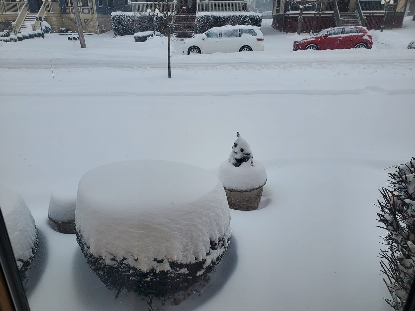
| Valparaiso, IN on the morning of Wednesday, February 2. Photo courtesy of Mark Meyer. | South Shore area of Chicago at 4:30 P.M. on the afternoon of Wednesday, February 2. Photo courtesy of Michael Galindo. |
 |
|
|
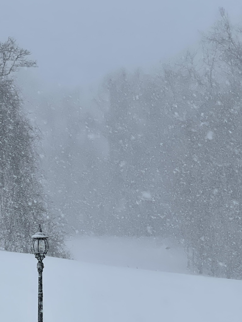
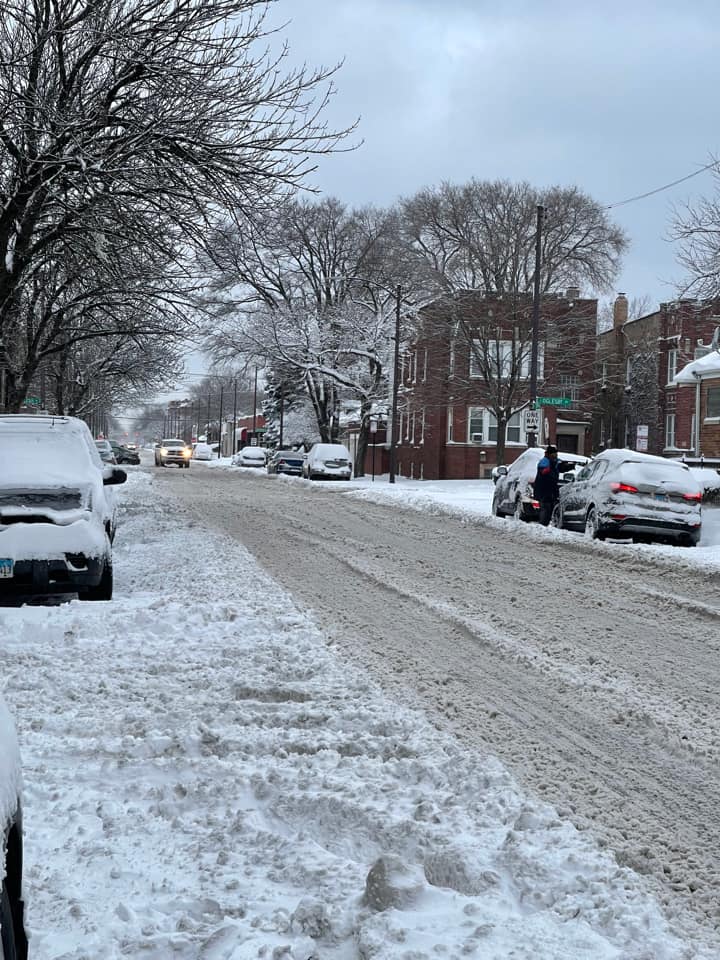
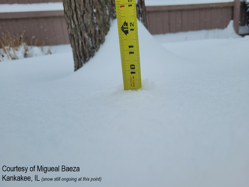
| Kankakee, IL from the afternoon on Wednesday, February 2. Photo courtesy of Miguel Baeza. | Lemont, IL late afternoon on Wednesday, February 2. Photo courtesy of Linda Elizabeth. | Northwest Indiana on the afternoon of Wednesday, February 2. Photo courtesy of Joe Pantuso. |
Service
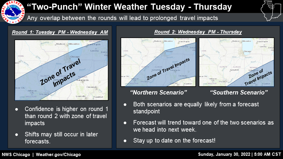
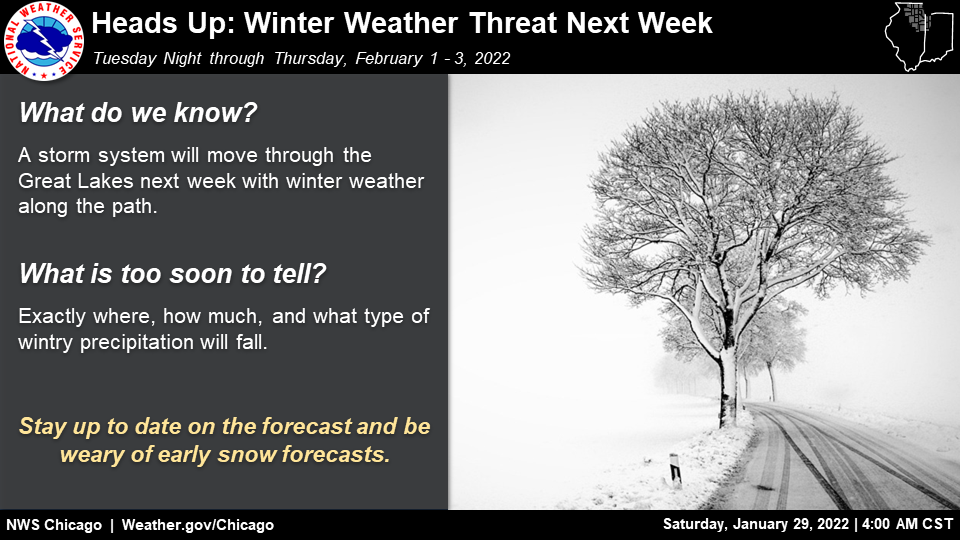
The below graphics are NWS Chicago Weather Stories issues leading up to the event. These were not the only Weather Story graphics issued pertaining to the forecast event, with others including forecast timelines and safety recommendations. One can find our current Weather Stories here.
 |
|
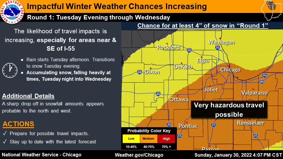 |
| Saturday, January 29 A.M. Weather Story | Sunday, January 30 A.M. Weather Story | Sunday, January 30 P.M. Weather Story |
 |
 |
| Monday, January 31 A.M. Weather Story for Feb 1 night-Feb 2 | Monday, January 31 A.M. Weather Story for Feb 2 night-Feb 3 |
 |
 |
| Monday, January 31 P.M. Weather Story for Feb 1 night-Feb 2 | Monday, January 31 P.M. Weather Story for Feb 2 night-Feb 3 |
 |
 |
| Tuesday, February 1 A.M. Weather Story for Feb 1 night-Feb 2 | Tuesday, February 1 A.M. Weather Story for Feb 2 night-Feb 3 |
Meteorology
 |
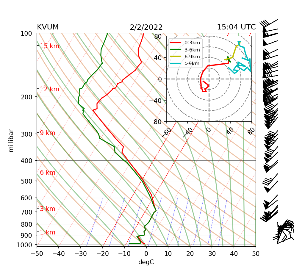 |
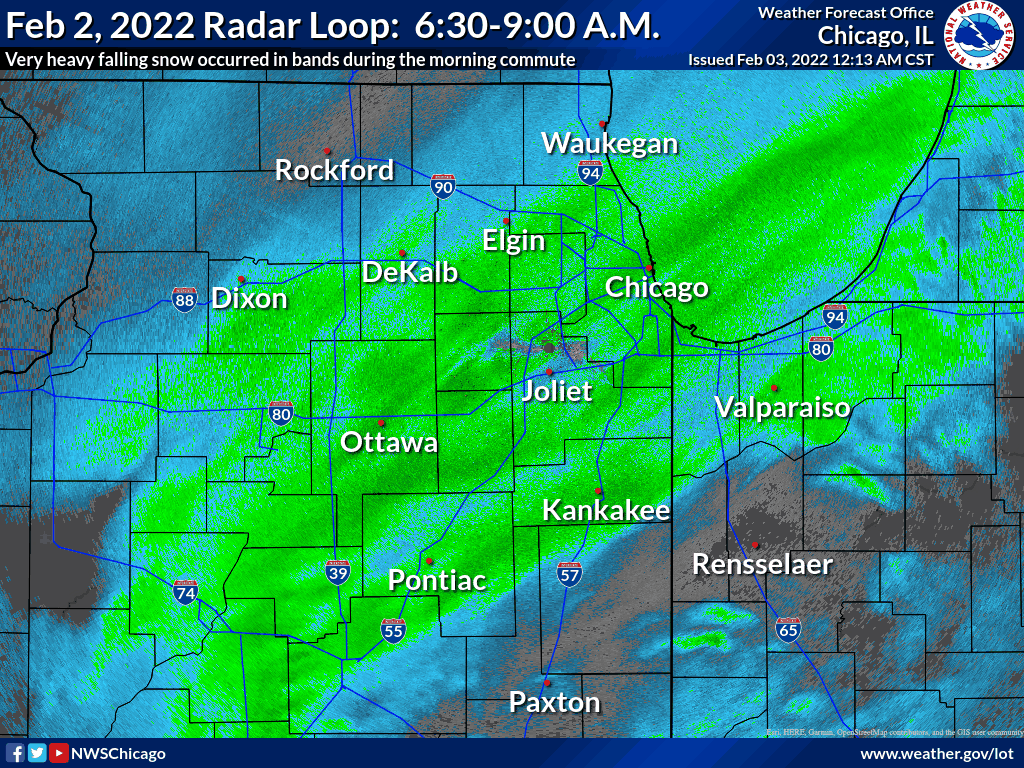
| February 2, 5:30-9:00 A.M. CST radar loop showing banded very heavy snowfall progressing through the Chicago metro and adjacent areas. This was during the morning commute and caused major travel impacts. | February 2, 9 A.M. CST weather balloon data plot (sounding) from Valparaiso University's Meteorology Department. This sounding reveals a deeply saturated profile sufficiently cold enough for snow. In addition, this saturated profile and the steep lapse rates (for conditionally unstable parcels) was through the dendritic growth zone for efficient snowflake production and growth. Finally, the strong winds noted aloft (above 400 mb) were signs of a strong upper jet maximum that assisted in broad scale lift for precipitation. |
 |
Media use of NWS Web News Stories is encouraged! Additional recaps can be found on the NWS Chicago Past Events Page. |
|