In the pictures: Scattered severe thunderstorms developed near a warm front in northern Arkansas during the evening of 03/06/2022. Later at night, a storm system ("L") arrived with a new cold front from the southern Plains, and triggered a line of strong to severe thunderstorms. Tornadoes and damaging winds were the main concerns. There was a slight to enhanced risk of severe weather. The day before, severe weather was focused in Iowa, and snow was on the horizon.
Arkansas severe weather season traditionally begins in March, and the setup was right for severe storms on the 6th. A warm front was in place across northern sections of the state, and the front separated springlike conditions to its south from much cooler air farther north. The contrast in temperatures helped create an unstable environment. Winds changed direction around the front, and this promoted rotation.in developing storms. Finally, an incoming storm system from the southern Plains was the trigger to get things going.
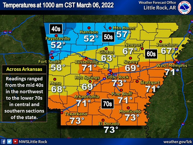
In the picture: There was a large temperature contrast across Arkansas at 1000 am CST on 03/06/2022. Readings ranged from the mid 40s in the northwest to the lower 70s in central and southern sections of the state.
As of 1000 am CST on the 6th, thermometers showed 73 degrees at El Dorado (Union County), Little Rock (Pulaski County), Monticello (Drew County), and Texarkana (Miller County). Readings at these locations eventually topped out in the lower 80s during the afternoon. Meanwhile, it was 45 degrees at Rogers (Benton County), and 52 degrees at Fayetteville (Washington County) and Harrison (Boone County). Given a change of seasons over a short distance, it was about to get interesting.
In the pictures/video: The WSR-88D (Doppler Weather Radar) showed a supercell (storm with rotating updrafts) moving from Searcy County into Stone County (northern Arkansas) at 630 pm CST on 03/06/2022. Rotation was persistent in the storm for several hours, and tornadoes were spawned.
Scattered showers and thunderstorms flared up during the afternoon, but it was one storm in particular that caught everyone's attention. This supercell (storm with rotating updrafts) tracked along the warm front, and intensified rapidly as it headed from southeast Johnson County into Pope County shortly after 500 pm CST. Less than twenty minutes later, there was a confirmed tornado a few miles northwest of Dover (Pope County).
In the video: A tornado (rated EF1) crossed Highway 7 about four to five miles north of Dover (Pope County) on 03/06/2022. Numerous trees were downed, and the trees fell on a vehicle as it moved through the area. Fortunately, the driver was not injured. The video is courtesy of Brian Emfinger via Twitter.
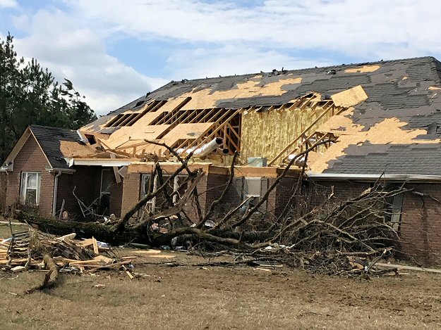
The tornado (rated EF1) crossed Highway 7 just north of Pleasant Valley (Pope County). Numerous trees were uprooted, and trees came down as a vehicle was driving through the area. Miraculously, the driver (a young man) was unharmed. Along the highway, the sliding doors at a volunteer fire department were blown out. To the west, a home took a direct hit, and much of its roof was roughed up. East of the highway, a 55 year old man was standing outside, and was injured after being thrown onto a steel gate on his porch. The tornado dissipated in the Ozark National Forest south of Solo (Pope County).
In the video: A tornado was witnessed as it neared Sage (Izard County) during the evening of 03/06/2022. There was a lot of lighting, and this illuminated the tornado. The video is courtesy of Piper Adams.
The storm cranked out another brief tornado (rated EF1) between Leslie (Searcy County) and Flag (Stone County). A stronger tornado (rated EF2) spun up to the southwest of Sage (Izard County) and tore through town. Numerous trees were snapped, and barns and sheds were destroyed (including a 1500 square foot horse barn). Several homes had roof damage. To the northeast, a mobile home was thrown, and one person was injured.
In the pictures: The most extensive tornado damage during this event was north of Pleasant Valley (Pope County), near Sage (Izard County), and west of Evening Shade (Sharp County). There was extensive tree damage, with roof damage to some houses. Several barns, sheds, and mobile/modular homes were destroyed.
As the tornado neared Evening Shade (Sharp County), a modular home was obliterated west of town (in Izard County). The occupants fled to a nearby metal shipping/storage container, and this rolled into some nearby trees. Four folks were injured (one seriously).
One more brief tornado (rated EF1) dismantled outbuildings and chicken houses southeast of Dalton (Randolph County). Soon after (by 830 pm CST), the storm weakened considerably.
In the picture: The WSR-88D (Doppler Weather Radar) showed strong rotation southwest of Gould (Lincoln County) and south of DeWitt (Arkansas County) at 215 am CST on 03/07/2022. Tornado Warnings were in effect.
As the evening progressed, the aforementioned southern Plains storm system dragged a cold front into the state. Ahead of the front, a line of showers/thunderstorms swept quickly eastward. Damaging winds and isolated tornadoes were the main concerns.
During the predawn hours of the 7th, a couple of discrete supercells popped up ahead of the line. The northernmost supercell cranked out weak tornadoes (rated EF1) north/west of Star City (Lincoln County) and north/west of Gillett (Arkansas County) between 115 am and 215 am CST. Mainly tree debris was found when the areas were surveyed, and a chicken house had tin removed.
In the picture: Six tornadoes were counted in the Little Rock County Warning Area from the late afternoon of 03/06/2022 into the wee hours of the next morning.
By the time the event ended, six tornadoes were confirmed in the Little Rock County Warning Area. As of 600 am CST on the 7th, thunderstorms exited far southeast Arkansas. Behind the cold front, there was a breezy northwest wind, and it was colder. Temperatures were in the 30s across the north/west, and there were reports of a brief wintry mix in places.
In the Memphis County Warning Area, there was a weak tornado (rated EF0) southwest of Cash (Craighead County) a few minutes after 400 pm CST on the 6th. A rain wrapped tornado (rated EF0) was witnessed east of McDougal (Clay County) just before 530 pm CST. Northwest of Weiner (Poinsett County), a metal shed was destroyed by damaging straight-line winds. Before dawn on the 7th, power poles and a tree were toppled southwest of Lexa (Phillips County).
There were narrow swaths of heavy rain (one to more than two inch amounts) during this event, especially where supercells were found (in the north and southeast). In the twenty four hour period ending at 600 am CST on the 7th, Hardy (Sharp County) had 2.60 inches of precipitation, with 2.09 inches at Pocahontas (Randolph County), 1.49 inches at Cane Creek State Park (Lincoln County), and 1.37 inches at Mountain View (Stone County).
On March 5, the #GOESEast ðŸ›°ï¸ captured imagery of multiple tornadic supercell thunderstorms as they raced across Iowa.
This visible channel imagery provides the finest spatial resolution available on the satellite's Advanced Baseline Imager. pic.twitter.com/uWf2Uts7EU
In the video: The satellite captured multiple tornadic supercells developing in Iowa on 03/05/2022.
Prior to the event (and maybe an omen), there was tragedy in Iowa. At least three supercells swept across the state on the 5th. There were multiple tornadoes, but the one that stood out cut a seventy mile path through four counties. This tornado was rated EF4, and had close to 170 mph winds as it reached Winterset, IA. Six people were killed, including four from the same family (a father, two children, and a grandmother). It was the first tornado of this magnitude in the state in nine years, and the second longest track since 1980. On the heels of the tornado, five inches of snow accumulated at Des Moines, IA on the 6th/7th.
In the picture: Severe weather reports in the seventy two hour period ending at 600 am CST on 03/08/2022. The graphic is courtesy of the Storm Prediction Center.
On the 7th/early on the 8th, there were hundreds of reports of wind damage from Maryland and Pennsylvania into part of New England. Downed trees and power lines blocked roads, and power outages were widespread.
Storm Reports
There were several reports of tornadoes, damaging winds, and some hail on March 6th/7th (early). For a look at the reports, click here.