The Winter Flood of January 1996
Overview | Photos | Additional Links
A number of factors came into place to set the stage for record-setting flooding in January of 1996. First, a cold start to the 1995/1996 winter allowed ice to form earlier and thicker than normal on Mid-Atlantic rivers. Then in the month leading up to the flooding, 4 separate snow systems moved across the region and dumped significant amounts of snow—the latest of which occurred less than a week before this event. On January 16th, observers measured 3” to 5.5” of liquid equivalent in the snowpack.
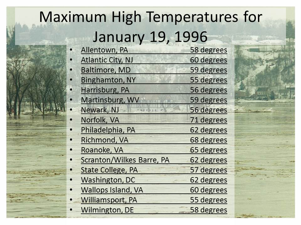
On January 17th, a surface low pressure system formed over the northern Rockies. By the morning of January 18th, steady winds from the south were moving warm, moist air into the region ahead of the low pressure system. By the overnight hours, temperatures had climbed into the 50s across much of the area with dewpoints approaching 50 as well. This strong flow of warm air and dewpoints reaching the 50s continued through midday on January 19th; creating ideal conditions to melt the deep snowpack that was covering the entire Mid-Atlantic region. By midmorning, most sites had reached their high temperatures for the day; listed in the table below.
As the cold front associated with the low pressure system swept through the region on the 19th, a line of showers and strong thunderstorms formed. Rain continued across the area through the afternoon of the 19th.
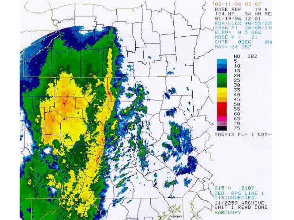
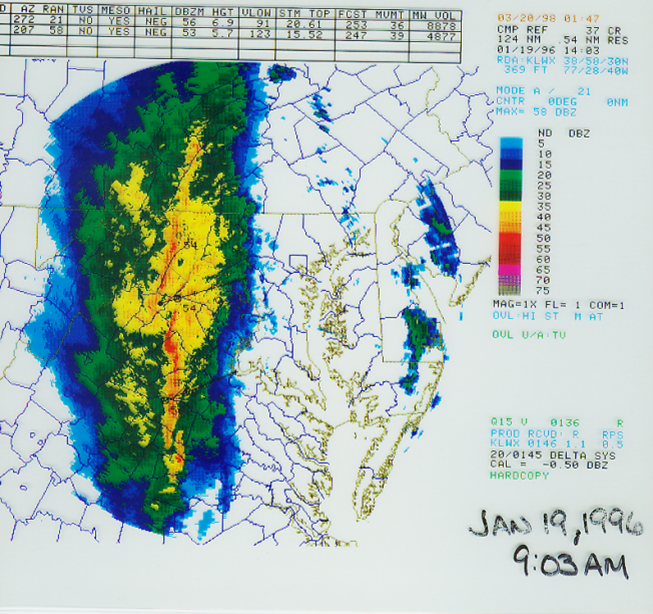
Radar images from the State College, PA (top - 7:00AM) and Sterling, VA (bottom - 9:00AM) radars the morning of January 19, 1996
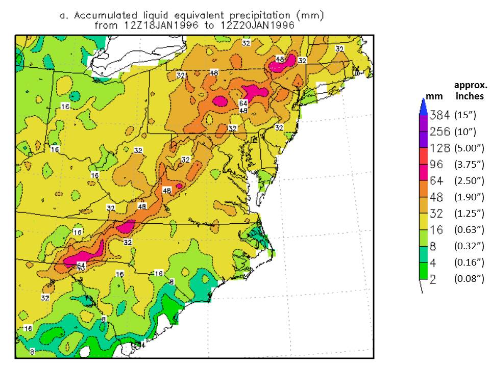
This heavy precipitation fell almost entirely as rain, and daily records were set at many stations. The image below shows rainfall totals from January 19th-20th:
This intense rainfall rate helped to accelerate the already rapidly melting snowpack, causing massive amounts of runoff to enter the rivers and streams. The rate of snowmelt was unprecedented. Residents recall going to bed the evening of January 19th with over a foot of snow on the ground and waking up the morning of the 20th with bare ground.

Significant rainfall combined with rapid snowmelt quickly caused severe flash flooding leading to larger river flooding as rivers rapidly swelled and spilled out of their banks. Additionally, the rapidly rising water from the rain and melting snow was powerful enough to break up and move ice on area rivers and streams, causing sheets to break free and flow downstream. As sheets of ice piled together, they created major ice jams that intensified the flooding.
This flooding was the worst to hit the entire Middle Atlantic River Forecast Center (MARFC) area in over 20 years. Some smaller streams broke their all-time flood records. Pennsylvania cities saw their worst flooding since Hurricane Agnes in 1972.
Flood Statistics - Of Approximately 150 MARFC River Forecast Points
| Total | Minor | Moderate | Major |
|---|---|---|---|
| 139 | 33 | 46 | 60 |

Harpers Ferry, WV on the Potomac River. Photo by David T. Gilbert.

Susquehanna River at City Island, Harrisburg, PA

Susquehanna River at Harvey Taylor Bridge, Harrisburg, PA

Confluence of Juniata and Susquehanna Rivers at Route 322 in Clarks Ferry, PA

Confluence of Juniata and Susquehanna Rivers at Route 322 in Clarks Ferry, PA

Susquehanna River along Routes 11 & 15 in Selinsgrove, PA

Susquehanna River from I-81 Bridge in Harrisburg, PA

Sherman's Creek

Conodoguinet Creek


Middle Atlantic River Forecast Center News Story
American Meteorological Society Journal Article
Susquehanna River Basin Commission Article
Video of the Walnut Street Bridge Collapse
NY Times Article - January 22, 1996
NY Times Article - January 23, 1996
Department of Environmental Protection Special Hydrologic Report
The information on this page was compiled as a collaboration between the Middle Atlantic River Forecast Center and NWS State College, PA by Bill Marosi and Elyse Hagner


 Send Us a Report