National Weather Service United States Department of Commerce
Click a location below for detailed forecast.

Last Map Update: Sun, Oct 5, 2025 at 2:02:41 pm CDT

Expect above average temperatures to continue with some isolated to scattered showers and thunderstorms. The weather will surely beckon many to the beach, but there is also a high risk for dangerous rip currents for all Gulf-facing beaches and minor coastal flooding during high tide. While an isolated shower or storm could occur anywhere in the area, they will be very low inland with the best chances near the coast and over the Gulf.
A Coastal Flood Advisory is in effect for the Southeast Texas Coastline from Saturday 2 PM to Sunday 7 AM, October 4-5, 2025. High tides around 4 feet above MLLW are expected, with possible beach erosion and minor coastal inundation.
A high risk of rip currents is in effect through at least Sunday night for Gulf-facing beaches. Numerous, strong, life-threatening rip currents are expected. Remember: Don't swim against the current. If you're caught, swim parallel to the shore, then angle back to the beach.
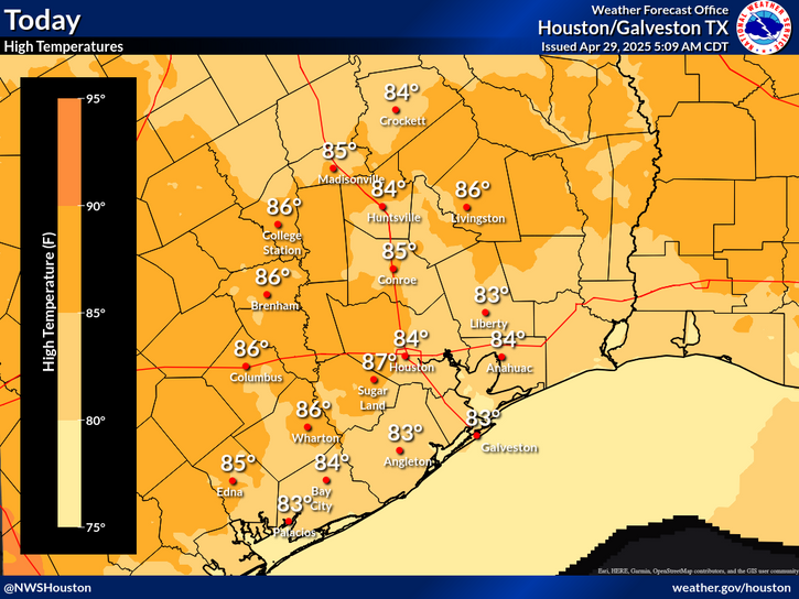
Don't expect much change in temperatures this week, with highs near or above average each day. A cold front will approach the region late in the week - and while it may not push through the area, we're expecting some drier air to filter in, which should at least help nights get modestly cooler! We'll also continue to expect isolated to scattered showers and storms each day, with the best chances earlier in the week and closer to the coast.
An extended period of warm weather and below normal rainfall has led to drought expansion across SE Texas with most of the area experiencing Abnormally Dry (D0) conditions with areas generally west of the Brazos Rive in Moderate Drought (D1). Continued drought expansion is expected over the next several weeks.


 Current Weather Observations...
Location Time
(CDT)
Weather Vsby.
(SM)
Temp.
(ºF)
Dewpt.
(ºF)
Hum.
(%)
Wind
(mph)
Wind Chill / Heat Index
(ºF)
Pres.
(in)
Crockett13:35Clear10896240NE 8G15-29.90
Caldwell13:15Clear10ENE 5-29.92
College Station12:53Clear10866448VRB 3-29.92
Huntsville12:53Clear10896646NNE 992 [HI]29.93
Brenham13:35Clear10886140NE 6-29.90
Navasota13:15Clear10936640VRB 695 [HI]29.89
Conroe12:53Clear10896443VRB 591 [HI]29.91
Cleveland13:35Partly Cloudy10876445E 3-29.89
Hooks Airport12:53Clear10876547E 10-29.90
Intercontinental Airport12:53Mostly Clear10876547ENE 8-29.89
Houston Hobby Airport12:53Partly Cloudy10866753ENE 7-29.88
Sugar Land12:53Clear10896646NNE 12G2092 [HI]29.88
Wharton13:35Clear10896443CALM91 [HI]29.88
Ellington Field12:54Clear10866651NE 8G16-29.87
La Porte13:10Clear10876752E 9-29.88
Angleton/Lake Jackson12:53Partly Cloudy10866957VRB 7-29.89
Galveston12:52Clear10846858NNE 8-29.89
Bay City13:15Clear10867160NNE 1092 [HI]29.84
Palacios12:53Light Rain10896951N 694 [HI]29.87
Rig 20 Miles SE of Galveston12:55Haze5787178-29.89
Rig 20 Miles SE of Matagorda13:15Mostly Clear10827374NE 18-29.91


Select another Date: