National Weather Service United States Department of Commerce
Click a location below for detailed forecast.

Last Map Update: Sat, Dec 6, 2025 at 8:44:15 am CST

KHGX Radar
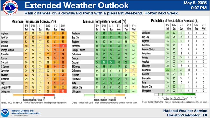
Brief warm-up this weekend with another round of cooler weather Monday behind a cold front. Afterwards, temperatures rise once again. Little to no rain expected. The rainfall chances seen for Saturday are mostly for the early morning hours.
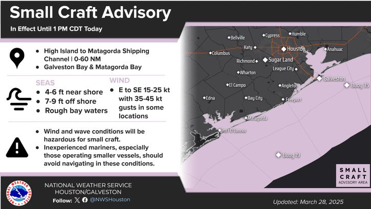
Image shows expected winds and seas Sunday through Tuesday. Gusty winds and building seas are likely to result in the issuance of Small Craft Advisories for Sunday evening through about midday on Monday.


 Current Weather Observations...
Location Time
(CST)
Weather Vsby.
(SM)
Temp.
(ºF)
Dewpt.
(ºF)
Hum.
(%)
Wind
(mph)
Wind Chill / Heat Index
(ºF)
Pres.
(in)
Crockett08:15Fog1/44242100CALM-30.01
Caldwell07:55Clear2 1/2CALM-30.01
College Station07:53Mist5444292SSE 541 [WC]29.99
Huntsville07:53Mist5464492S 543 [WC]30.00
Brenham08:15Mist3434295CALM-30.00
Navasota08:15Mist54444100CALM-30.00
Conroe07:53Mist4444395CALM-30.01
Cleveland08:15Mist4434295CALM-30.02
Hooks Airport07:53Mist4464595ESE 3-30.01
Intercontinental Airport07:53Mostly Cloudy10484692CALM-30.01
Houston Hobby Airport07:53Mist6524989E 5-30.00
Sugar Land07:53Clear7524782CALM-30.01
Wharton11:35Mostly Cloudy10847063S 25G36-29.89
Ellington Field07:54Mist6515093ENE 3-30.00
La Porte14:15Clear10533651NNW 5-30.11
Angleton/Lake Jackson07:53Mist5514992E 3-30.01
Galveston07:52Overcast9535192NE 3-30.03
Bay City08:15Overcast85252100CALM-29.98
Palacios07:53Mist5535192CALM-30.02
Rig 20 Miles SE of Galveston08:15Overcast10575387CALM-30.03
Rig 20 Miles SE of Matagorda08:15Mist55959100NNE 16-30.05


Select another Date: