
Flash flooding threatens areas from the Tennessee Valley to the Carolinas as storms repeat along a stalled front. Monsoonal storms may trigger flooding in the Southwest. Dangerous heat expands across the Desert Southwest, Plains, mid-Mississippi Valley and Southern Tier. Critical fire weather for interior Pacific Northwest. Cooler, drier air brings brief relief to the Great Lakes and Northeast. Read More >
| NWS Huntsville Management History - Office Awards |
| 2019 | March 14: A storm system produced sporadic wind damage and an isolated tornado ino Cullman county from the White City to Holly Pond. This tornado was an EF-1 tornado with peak winds of 105 mph and a path length of just over 11 miles. |
| February 17th-February 23rd: February 17th-February 23rd: Very heavy rainfall totaling between 10 and 15 inches of rainfall began on February 17th and continued off an on through February 23rd. With very saturated soil conditions in place prior to this rainfall, this additional heavy rainfall quickly lead to significant flash, areal, and river flooding that intensified significantly between the 21st and 23rd. Even more serious river flooding continued to escalate after this rainfall ended through February 24-26, as runoff pushed many river points and tributaries along the Tennessee River to moderate or major flood stage, before beginning to slowly fall. Many tributaries along the Tennessee River did not fall below flood stage until around or after the second week of March. A few river points including the Tennessee River at Florence did not drop below flood stage until March 14th. | |
| 2018 | November 5-6: A strong storm system produced widspread damaging winds in northwestern Alabama northeast into Southern Middle Tennessee (as well as a tornado near Scottsboro, AL) after midnight during the very early morning hours prior to daybreak. The strongest EF-2 tornado occurred in the Estill Springs area and it's track was over 15 miles long. |
| June 28th: A significant damaging wind event occurred across the region on Thursday, June 28, 2018, from an intense complex of severe thunderstorms that moved through the Tennessee Valley, southward through the state of Alabama, and into the Gulf of America -- nearly 400 miles traversed! Winds to 100 mph were surveyed along portions of this system in the Killingsworth Cove area of Madison county. | |
| April 3rd: A strong storm system produced widespread damaging winds with some recorded gusts between 70 and 75 mph. This produced quite a bit of straight-lined wind damage in the Decatur and Limestone county areas, as well as further east. | |
| March 31st: A very strong storm system produced widespread extremely large hail (3 to over 5 inches in diameter), wind damage, and several tornadoes across northern Alabama and Southern Middle Tennessee, especially south of the Tennessee River. | |
| Mid-Late Jan: Dry conditions allowed abnormally dry to moderate drought conditions to return to portions of northern Alabama and Southern Middle Tennessee. The worst conditions developed east of I-65. | |
| Jan 16: A trace to 1 inch of snowfall fell across much of northern Alabama along and behind a cold front that moved southeast into an arctic air mass over the eastern CONUS on January 16th-17th. This system produced even heavier snowfall in northwestern Alabama and Southern Middle Tennessee, where snowfall totals were between 1 and 3 inches. | |
| 2017 | Nov 18: Just enough surface based instability developed ahead of a very dynamic cold front to produce a line of numerous severe thunderstorms that moved through northern Alabama and Southern Middle Tennessee. These severe storms produced numerous damaging winds reports and two EF-1 tornadoes. One to three inches of rain also fell. |
| Aug 31: Tropical depression Harvey moved northeast from Lousiana on the 29th into northern Mississippi on August 31st. Strong to severe thunderstorms developed near and just east of the center of circulation of this system as it moved northeast along with a warm front extending eastward into Georgia from this tropical depression. Multiple tornadoes occurred over Mississippi and one EF2 tornado along with isolated wind damage occurred in Cullman county, Alabama. | |
| Aug 21: A total solar eclipse occurred across the United States during the afternoon of August 21, 2017. Although totality was not quite reached in the Tennessee Valley (92-96% Peak Obstruction), the region did not some meteorological effects. The temperature dropped 10 degrees from a high of 95 degrees early in the afternoon to 85 degrees during the peak of the event. Diurnal cloud cover from convective heating also dissipated with the moon's shadow blocking the sun's rays. | |
| Mid-Late May: Additional heavier rainfall helped to basically put an end to more serious drought conditions, as just a few areas in northern Alabama remained only abnormally dry. These conditions remained in place through the end of 2017. | |
| May 27-28: Very moist and unstable conditions were in place ahead of a cold front edging southward toward the area on the afternoon hours of May 27th. A area of strong to severe thunderstorms developed along a convergence area in southern Middle Tennessee ahead of the front during the late night hours on May 27th and pushed southeast into northern Alabama and re-intensified during the early morning hours of May 28th. These severe storms produced numerous reports of damaging winds, including a few reports of wind gusts that were at least 75 mph. | |
| May 20: Daytime heating developed ahead of an approaching frontal boundary pushing east into northwestern Alabama during the early-mid afternoon hours on May 20th. Multiple occurrences of damaging winds were reported with this activity, especially in Madison county, AL. Heavy rainfall between 1 and 4 inches also fell with this event. | |
| Apr 30: A line of strong to severe thunderstorms moved east across northern Alabama during the afternoon hours on April 30th. Several bow echoes developed along the line producing multiple wind damage reports and an isolated tornado. | |
| Apr 5: Very quick moving severe storms developed ahead of a strong cold front late in the afternoon and evening hours in northern Alabama. These storms produced up to golfball size hail. | |
| Mar 28 - Apr: Recent rainfall in March helped ease drought conditions some. However, abnormally dry to moderate drought conditions remained in place over northern Alabama. | |
| Mar 27: Two waves of severe weather developed ahead of an approaching storm system on March 27th. One round of severe weather produced primarily large hail and some wind damage. The second wave of severe weather occurred ahead of the cold front associated with this storm system with a severe MCS which produced additional large hail and wind damage. One to four inches of rainfall also fell. | |
| Mar 21: A Mesoscale Convective System (MCS) moved into Tennessee from Missouri and interacted with a unstable airmass over the Nashville WFO and northern Alabama. As it did so, the MCS became severe producing widespread wind damage and some large hail as it pushed southeast into northern Alabama. | |
| Mar 9: A severe mesoscale convective system (MCS) developed ahead of an approaching cold front during the evening hours in southwestern Missouri and northern Arkansas. It moved southeast through northern Alabama and Southern Tennessee just after midnight into the very early morning hours. Damage was primarily straight line wind damage. However, an isolated EF-1 tornado was also produced along with some large hail. Up to 2.5 inches of rain fell in northwestern Alabama. | |
| Mar 1: A strong cold front produced very large hail (1 to 2.5 inches) and wind damage across northern Alabama and Southern Middle Tennessee. | |
| Jan 22-23: A strong storm system brought heavy rainfall (2 to 5 inches in 48 hours) to northern Alabama. This produced flash flooding and river flooding in portions of northern Alabama (mainly east of I-65). This did improve droughts conditions some, but much of northern Alabama remained in moderate to severe drought conditions. | |
| Jan 1-22: Moderate to Extreme drought conditions remained in place over much of northern Alabama, due to extreme rainfall deficits seen earlier during the summer/fall conditions of 2016. |
| 2016 | December 17-18 : Strong to severe thunderstorms affected portions of northern Alabama(especially northwestern Alabama), producing two weak tornadoes. |
| Early December - Some Drought Relief: Drought conditions improved due to heavy rainfall of 3 to 6 inches seen on Dec 29-30, followed by several rain events that provided an additional 2 to 5 inches of rainfall across the Tennessee Valley. The heaviest amounts were seen along a line from the Bankhead forest area northeast to near Winchester, TN. Despite this rainfall, much of northern ALabama and Southern Tennessee remained in Severe to Extreme drought conditions. | |
| Nov 29-30 - Severe Weather Event: A tornado outbreak occurred during the evening hours of the 29th into the early morning hours of the 30th. A very mild and unstable air mass was in place along with a strong southwesterly upper level jet. These ingredients combined with a cold front and pre-frontal trough sweeping from west to east across the area sparked scattered supercell thunderstorms during the evening, a few of which were tornadic. | |
| Nov 12-14 - Poor air quality conditions develop in Huntsville, AL and Decatur, AL due to smoky conditions: Easterly Winds from nearby forest fires in GA, TN, and NC advect enough smoke into northern Alabama to produce dangerous air quality conditions outdoors. Visibilities were reduced to around 3 miles at times at the Decatur Airport and Huntsville International Airport. Visiblities in northeastern Alabama were even worse with some location such as the Fort Payne Airport experiencing visibilities due to smoke dropping to around 1 mile on the 13th and 14th. | |
| Sept. - Oct. Drought Worsens Again: Very little rainfall occurs with even northwestern Alabama over rainfall totals 3 inches below normal each month. This plunged the area again into severe to extreme drought conditions. | |
| Aug - Some Drought Relief: Some relief finally with above normal monthly rainfall totals experienced near and west of I-65. Temporarily these areas fall out of drought conditions. Further east though drier conditions prevailed and severe to extreme drought conditions continued. | |
| June 28th - Significant Drought Conditions Worsen in Northeastern AL: Northeastern Alabama continued to remain drier than normal causing exceptional drought conditions to develop in those areas. | |
| May 17th - Significant Drought Conditions Developed: Monthly rainfall defecits lead to Moderate Drought conditions across northern Alabama and this further expanded into Tennessee by the end of the month. In fact, by the end of the month areas east of I-65 experienced Severe Drought conditions. | |
| March 30-31: A strong slow moving cold front brought two rounds of heavy rainfall to the Huntsville Forecast area between the 30th and 31st of March. The second round of precipitation included strong to severe thunderstorms which produced 1 EF2 tornado (extending from just NNE of Hartselle to just east of Priceville and further northeast), large hail (1 inch in diameter), and some damaging winds. Three to 6 inches of rainfall was recorded after both rounds of precipitation ended by midnight on the 31st in Southern Middle Tennessee significant flash flooding and river/stream flooding. | |
| February 9, 2016: One to three inches of snow fell over Morgan county in Alabama northeast into portions of northeastern Alabama and into Franklin and Moore counties in TN. The heaviest amounts o f snow in the Huntsville Forecast area fell in Southern Middle TN and northern Jackson county. The exception to this was an unusual river effect band of snowfall which dropped between 2 and 3 inches in and near the Morgan City area. |
| 2015 | May 27: One to three inches of rainfall fell across northern Alabama. This was on top of 3-6 inches of rainfall that fell in northwest Alabama a few days prior. Even heavier amounts between 3 and 4 inches fell in the Russellville area, on the 27th, causing serious flash flooding. |
| April 24-26: National Weather Service personnel from the Huntsville Forecast Office staffed a booth at the 3-day Panoply Arts Festival in Huntsville Alabama disseminating weather information and answering questions. | |
| April 3: A strong cold front (upper 60s ahead of the front dropping to upper 30s to lower forties behind the front) over southeastern Missouri and Indiana brought a round of severe weather, including large hail, damaging winds and two tornadoes to northern Alabama. The stronger F1 tornado affected Ider community. Both tornado paths were under 3 miles in length. | |
| March 4-5: A strong slow moving cold front brought heavy sleet accumulations to northern Alabama and Southern Middle Tennessee. Most sleet accumulations through the early morning hours on March 5th were between 0.5 and 1.0 inches (most of this fell between midnight and 7 AM). Higher amounts were seen in Lauderdale, Colbert, Morgan, Madison, and western Jackson counties in Alabama (1.0 to 1.5 inches of sleet). | |
| February 25-26: On Wednesday, February 25, 2015, much of the northern two-thirds of the state received heavy snowfall during the afternoon and evening hours. Between 10 and 12 inches of snow was reported in parts of Jackson county (AL), Lawrence county (AL), portions of Marshall county (AL), and southern Franklin county, (AL) as well. further north into Southern Middle TN between 2 and 9 inches of snow was reported. | |
| January Through February: The "StormReady" status of all the northern Alabama counties in Huntsville Forecast Area was renewed. |
| 2014 | October 25: NWS Huntsville personnel manned a booth at the Jack Daniels World BBQ Championship in Winchester, TN. |
| October 13-14: A strong storm system produced damaging winds (between 70 mph and 100 mph in some locations) in portions of north-central Alabama and one EF-1 tornado in Tuscumbia, AL. Heavy rainfall also fell (between 2 and 5 inches) across much of northern Alabama and southern middle Tennessee, causing some isolated river/flash flooding in the Fort Payne and Brownsboro communities. | |
| October 8: Training of strong to severe thunderstorms along a slow moving cold front produced heavy rainfall over northwestern Cullman/southwestern Morgan Counties. In addition, dime to softball size hail fell. Softball size hail is unusual in October, but not unheard of. | |
| October 2: A strong storm system produced two tornadoes (EF-0 in Madison County and a EF-1 in Marshall County) and damaging winds in northern Alabama. One to three inches of rainfell east of I-65 and in extreme northwestern Alabama as well. | |
| September 6: NWS personnel manned a booth at the Disaster Preparedness Fair in Dekalb County. | |
| May 3: National Weather Service personnel from the Huntsville Forecast Office staffed a booth at the SOS Children's Safety Festival. | |
| April 28-29: A very strong storm system produced 13 tornadoes (4 EF-3's, 3 EF-2's, 5 EF-1's, and 1 EF-0), numerous straight-lined wind damage reports, and some small hail across Northern Alabama and Southern Middle Tennessee. This system also produced heavy rainfall totals between 3 and 5 inches in some locations causing flash flooding to occur in the Fort Payne and Princeton communities. | |
| April 25-27: National Weather Service personnel from the Huntsville Forecast Office staffed a booth at the 3-day Panoply Arts Festival in Huntsville Alabama. Staff disseminated weather information and answered questions. | |
| April 9: The National Weather Service in Huntsville, AL conducted a Skywarn Spotter Class for the Deaf and Hard of Hearing. | |
| April 5: The National Weather Service office in Huntsville, AL along with other Weather Service offices participated in the Joint Partner's Workshop in Pulaski, TN. In this workshop, NWS Nashville and Huntsville along with state/county EMAs and local media all came together to learn about each other's role in severe weather events and how to better communicate with each other to accomplish the common goal of providing life-saving weather information. | |
| March 13: The Huntsville International Airport was designated a StormReady Supporter. | |
| February 20-21: A strong storm system produced 8 tornadoes (1 EF-2 and 7 EF-1's), numerous straight-lined wind damage reports, and some small hail across Northern Alabama and Southern Middle Tennessee. | |
| February 13: A potent storms system brought heavy snowfall totalling between 6 and 10 inches mainly south of the Tennessee River and east of interstate 65. Further west and north into Southern Middle Tennessee, one to four inches of snowfall accumulation was common. | |
| February 10-11: A potent storm system brought heavy snowfall totalling between 3 and 6 inches mainly south of the Tennessee River and east of interstate 65, with the heaviest amounts occurring in parts of Cullman, Morgan, Marshall, and Dekalb counties. Further west in northern Alabama, 1 to 2 inches of snowfall was common with isolated higher amounts up to 6 inches in western Lauderdale County. | |
| January: A very cold weather pattern in place for much of the month produced the 8th coldest on record at the Huntsville International Airport (average monthly temperature was 33.8 degrees/7.7 degrees below normal) and the12th coldest at the Muscle Shoals Regional Airport (average monthly temperature was 35.2 degrees/5.8 degrees below normal). |
| 2013 | October 31: A very windy Halloween night was experienced across the Huntsville Forecast Area with as non-convective winds gusted to between 40 and 50 mph, especially in higher elevations. Even in lower elevations wind gusts to around 40 mph were common. |
| October 23: Huntsville International Airport recognized as a StormReady location (only the 10th airport in the country to be StormReady). | |
| July 4: Extremely heavy rainfall occurred between 7 am CDT on July 3rd through 7 am CDT on July 4th across northern Alabama and Southern Middle Tennessee, especially in western Madison, western Morgan, and much of Lawrence counties. Between 4 and 8 inches of rainfall occurred during this period causing some flash flooding/flooding impacts in those counties. | |
| June 16-18: A series of disturbances embedded in westerly flow interacted with an unstable and moist atmosphere to produce between 2 and 6 inches of rainfall over portions of the Tennessee Valley. | |
| June 9: One EF-1 tornado and 1 EF-0 tornado touched down in Franklin county Tennessee. Although not unheard of, tornadoes are more uncommon in the summer months. | |
| June 4: Deaf and Hard of Hearing Spotter Class held at the Alabama Department of Rehabilitation Service Center in Decatur, AL. Free emergency preparedness backpacks were given out at the event by the Alabama Department of Rehabilitation Services thanks to a grant by the Public Health Department. | |
| May 3-6: Between May 3rd and May 6th, a slow moving cold front and mutiple upper level disturbances brought an extended period of heavy rain and cooler temperatures to much of Northern Alabama, especially in locations east of I-65. This lead to impressive rainfall totals between 6 and 8 inches in southern Madison, central Marshall, and SW Dekalb counties for the entire period. This forced several river points along the Tennessee River to climb above flood stage. | |
| March 18: A storm system brought severe storms producing 2 EF-2 tornadoes (affecting primarily Marshall and Dekalb counties in Alabama), 1 EF-1 tornado, 1 EF-0 tornado, damaging winds, and hail up to 1.5 inches in diameter to the Huntsville Forecast Area. | |
| March 12: Deaf and Hard of Hearing Spotter Class held at the Alabama Institute for the Deaf and Blind-Shoals Regional Center in Tuscumbia, AL. | |
| March 1-3: A weak upper level system combined with low level moisture to bring a prolonged period of light snow to the Tennessee Valley Friday afternoon through Sunday morning, March 3rd. Due to the fairly warm ground temperatures and light nature of the snowfall, much of the snow melted as it fell across the region. However, a few locations received measurable snowfall during the period. | |
| January 30: A storm system brought strong to severe storms to the area including 2 EF-1 tornadoes, damaging winds, and some isolated flash flooding to the Huntsville Forecast Area. | |
| January 17: Moderate to heavy snowfall fell across central portions of north central Alabama, as a potent upper level low pressure system moved quickly through Alabama and Georgia Thursday and Thursday night. This produced heavy snowfall across Morgan, Cullman, and Marshall counties, and the southern portion of Madison county of the Huntsville Forecast area totaling up to 4 inches. Lighter amounts around a trace to a few hundredths of an inch fell across much of northwestern Alabama and portions of Southern Middle Tennessee. | |
| January 10: Redstone Arsenal and Marshall Space Flight Center were designated as StormReady. |
| 2012 | December 5: Nucor Steel (Decatur, AL) was recognized as a StormReady Supporter. |
| October 1: National Weather Service (NWS) Huntsville was part of the University of Alabama at Huntsville's (UAH's) Weather Fest. A day of weather information and activities at the UAH campus. | |
| September 13: A Deaf and Hard of Hearing Spotter Class was held at the Alabama Department of Rehabilitation Services Center in Huntsville, AL. Free NOAA Weather Radios and strobe light attachments were given out by the Alabama Department of Rehabilitation Services thanks to a grant by the Public Health Department. | |
| June 13: AWIPS II workstations installed and operational testing and evaluation initiated at NWS Huntsville Forecast Office. | |
| June 1: Northeast Alabama Community College was designated a StormReady Supporter. | |
| May 23: University of North Alabama recognized as a StormReady University. | |
| April 27-29: National Weather Service personnel from the Huntsville Forecast Office staffed a booth at the 3-day Panoply Arts Festival in Huntsville Alabama. Staff disseminated weather information and answered questions. | |
| April 5: The temporary Cullman NWR transmitter broadcasting at 162.450 MHz was replaced with a new permanent transmitter, restoring the original broadcast coverage area for this transmitter destroyed during the April 27th, 2011 Severe Weather Outbreak. | |
| March 2: A strong storm system produced six tornadoes and numerous reports of large hail up to the size of softballs. Two significant tornadoes impacted portions of Limestone and Madison counties producing extensive damage. | |
| February 22: All Northern Alabama counties in the Huntsville Forecast Area were re-designated as Storm Ready. | |
| January 12: Dual Pol Radar Upgrade was completed at the Hytop, AL WSR 88D radar site. |
| 2011 | September 19: Lincoln County TN was re-designated as StormReady. |
| September 17: National Weather Service (NWS) Huntsville was part of the University of Alabama at Huntsville's (UAH's) Weather Fest. A day of weather information and activities at the UAH campus. | |
| May 5: NWS Huntsville began its presence on Facebook. | |
| April 27: A historic tornado outbreak more deadly than the Super Outbreak of 1974, with 39 tornadoes (including 3 E-F5s, 4 EF-4s, and 12 EF-2s), impacted the Huntsville Forecast Area. One hundred fatalities and ninety-four injuries were directly related to the tornadoes in the Huntsville Forecast Area alone. | |
| March 19: Huntsville ended its 2nd snowiest winter season on record. The seasonal snowfall total was 14.3 inches. | |
| February 28: A storm system moved through the Tennessee Valley producing widespread straight-line wind damage and a few embedded tornadoes. An EF-2 tornado that tracked across Moore and Franklin Counties in Tennessee killed one person while injuring 4 others. | |
| February 11: The University of Alabama campus in Huntsville was dedicated as Storm Ready. | |
| January 10 to 16: Snow was measured on the ground at Huntsville for seven consecutive days from January 10th to 16th, which was the longest streak on record. | |
| January 9-10: A powerful low pressure system brought very heavy snowfall to the area with locations in northwestern Alabama reporting over a foot. The heavy snowfall shut down Huntsville and other portions of northern Alabama for a few days. |
| 2010 | December 24-25: Two to locally seven inches of snowfall produced a white Christmas across northern Alabama. |
| October 16: NWS Huntsville participated in the University of Alabama at Huntsville's (UAH's) first Weather Fest. A day of weather information and activities at the UAH campus. | |
| September 22: The hottest summer recorded at Huntsville and the Muscle Shoals area ended. | |
| &nbnbsp; | September 3: Moore County TN was re-designated StormReady. |
| April 23-25: National Weather Service personnel from the Huntsville Forecast Office staffed a booth at the 3-day Panoply Arts Festival in Huntsville Alabama disseminating weather information and answering questions. | |
| April 24: A powerful storm system produced one EF-4 tornado, two EF-3 tornadoes, and one EF-2 tornado across north central and northeast Alabama. | |
| February 8: Three to six inches of snow fell across portions of northwestern Alabama and near the Tennessee state line in northern Alabama. | |
| January 21: A powerful storm system produced a rare and significant severe weather event in January. This event produced two tornadoes (one strong EF-2 and another EF-1) and hail as big as baseballs. The EF-2 touched down in downtown Huntsville and produced significant damage. |
| 2009 | December 16: Franklin county TN was re-designated as StormReady. |
| December 8-9: A slow moving storm system produced as much as four to eight inches of rainfall across following counties in northern Alabama: Madison, Morgan, Lawrence, Jackson, and DeKalb county. This caused widespread and serious flash flooding and river flooding across Morgan and Madison counties in northern Alabama. | |
| April 24-26: National Weather Service personnel from the Huntsville Forecast Office staffed a booth at the 3-day Panoply Arts Festival in Huntsville Alabama disseminating weather information and answering questions. | |
| April 19: A severe weather event produced six tornadoes (3 EF-0s and 3 EF-1s) across Lawrence, Morgan, Marshall, and DeKalb counties, killing one person and injuring 14 others. | |
| April 12-13: A Wake Low Event caused widespread wind damage across the Huntsville forecast area. | |
| April 10: An EF-3 tornado moved through Marshall, southern Jackson, and west central DeKalb counties causing extensive and widespread damage. | |
| April 2: A strong storm system produced several tornadoes across northern Alabama. |
| 2008 | December 10: An EF-2 tornado affected central Jackson county. This is unusually late for tornadoes to occur, but not unprecedented for severe weather in northern Alabama. |
| May 8: Seven tornadoes, from EF-0 to EF-2 in intensity, affected north central and northwest Alabama. | |
| May 4: The FAA dedicated a new 228 foot tower at the Huntsville International Airport. FAA Contract Weather Observers moved to the tower to conduct operations shortly afterward. | |
| April 25-27: National Weather Service personnel from the Huntsville Forecast Office staffed a booth at the 3-day Panoply Arts Festival in Huntsville Alabama disseminating weather information and answering questions. | |
| Feb 6: During the Super Tuesday Outbreak, two devastating EF-4 tornadoes ripped through Lawrence, Morgan, and Jackson counties. |
| 2007 | A Moderate to Exceptional Drought affected the Huntsville Forecast area and much of Southern Middle Tennessee. |
| November 14: Alabama joined the Community Rain/Hail/Snow Mesonet Network (COCORAHS). | |
| October 27: National Weather Service (NWS) Huntsville began participating in the Jack Daniel's Barbeque Invitational. Personnel staffed a booth at the event promoting weather safety and providing weather information. | |
| October 1: The NWS, including the Huntsville office, converted from county based warnings to storm based warnings. | |
| April 27-29: National Weather Service personnel from the Huntsville Forecast Office staffed a booth at the 3-day Panoply Arts Festival in Huntsville Alabama disseminating weather information and answering questions. | |
| February 1: The NWS replaced the old F-scale system for rating tornadoes with the new EF Scale rating system developed by Texas Tech University. |
| 2006 | A Moderate to Exceptional Drought affected the Huntsville Forecast area and much of Southern Middle Tennessee: Many locations across the Huntsville County Warning Area saw their driest year on record. At Huntsville, precipitation for the year was only 28.65 inches which was a remarkable 22.57 inches below normal. In fact, it beat out the previous driest year, 1925, by 8.53 inches! |
| April 28-30: National Weather Service personnel from the Huntsville Forecast Office staffed a booth at the 3-day Panoply Arts Festival in Huntsville Alabama disseminating weather information and answering questions. |
| 2005 | August 29: Remnants of Hurricane Katrina brought heavy rain and tropical storm force wind gusts between 40 and 50 MPH to the Huntsville Forecast Area. One gust to 71 MPH was reported at the Muscle Shoals Airport. |
| February 21: Severe thunderstorms produced penny to softball size hail and wind damage across northern Alabama. |
| 2004 | December 1-9: Following a wet November, eight to ten inches of rain fell mainly north of the Tennessee River. This caused widespread river flooding across much of the Tennessee River. Especially hard hit were areas in northwestern Alabama. |
| September 17: Remnants of Hurricane Ivan produced copious rainfall totals between three and nine inches along with widespread flooding. Tropical storm force winds to just over 50 mph were experienced as well. | |
| Memorial Day Weekend: A large squall line moved across the Huntsville Forecast Area causing widespread wind and tornado damage. Significant damage occurred in and near McFarland Park along the Tennessee River. | |
| January 14: The National Weather Service in Huntsville celebrated its first anniversary of operations as a local WFO. U.S Representative Bud Cramer (D-AL) joined the festivities. |
| 2003 | November 5: WFO Huntsville assumed forecast and warning responsibilities for Lincoln, Moore, and Franklin counties in Tennessee. |
| June 24: NOAA Weather Radio station WNG-642 in Arab went on the air. | |
| May 2: A massive hail event occurred across the Tennessee Valley and produced widespread golf ball to baseball size hail. Hail as large as softballs fell in parts of Colbert and Lauderdale counties. | |
| January 14: WFO Huntsville reopened at the National Space Science and Technology Center (NSSTC) building on the University of Alabama at Huntsville (UAH) campus at 10am. WFO Huntsville then assumed forecasting and warning responsibility for the original CWA, plus Cullman County. |
| 2002 | December: NOAA Weather Radio station WNG-554 was installed on Keith Springs Mountain in Franklin County, TN. |
| 1999 | June 28: Six to eight inches of rain fell between midnight and 6 am causing widespread extensive flash flooding over southern portions of Huntsville. |
| 1997 | December 2: WSO Huntsville transferred warning responsibility for its County Warning Area (CWA) to Weather Service Forecast Office (WSFO) Birmingham at 10am. WSO Huntsville then became a "spindown" office. |
| July 1: Hytop radar became operational after a testing period. | |
| April 25: Dome installed on new Hytop WSR-88D (NEXRAD) radar. | |
| April 8: The ASOS at Northwest Alabama Regional Airport in Muscle Shoals was commissioned. |
| 1996 | October 23: ASOS at Pryor Field in Decatur was commissioned. |
| April 3: NOAA Weather Radio station WWF-66 in Cullman was put on the air. |
| 1995 | May 18: A devastating long track F4 tornado stayed on the ground for 39 miles across Limestone, Madison, and Jackson counties. The Anderson Hills area was particularly hard hit by this tornado. |
| 1994 | December 16: NOAA Weather Radio station WWF-44 near Henagar was put on the air. |
| August 1: ASOS at Huntsville International Airport was commissioned. |
| 1993 | March 12-14: "Storm of the Century" dumped up to 17" of snow on the Tennessee Valley. |
| 1991 | WSR-74C radar at WSO Huntsville received Doppler upgrade. |
| 1989 | November 15: A F4 tornado struck South Huntsville during evening rush hour. Tragically, it left great destruction in its wake in the Airport Road area, while killing 21 people and injuring 463 others. |
| 1985 | January 21: Huntsville tied its coldest low temperature ever recorded of eleven degrees below zero Fahrenheit. |
| 1980s | Early 1980s: AFOS computer system was installed, replaced facsimile and teletype machines. |
| 1978 | March 20: Huntsville experienced the end of its coldest winter season on record. The average temp was 35.4 Fahrenheit over the entire winter period. |
| 1977 | March 4: NOAA Weather Radio station KIH-57 in Florence went on the air. WSR-74C radar installed at WSO Huntsville, replacing the older WSR-3 radar. |
| 1976 | January 14: NOAA Weather Radio station KIH-20 was put on the air in Huntsville. |
| 1974 | April 3: The "Super Outbreak" of tornadoes hit the eastern U.S. Approximately 60 people were killed and hundreds more were injured in the Tennessee Valley alone. |
| 1973 | March 16: Major flooding occurred across the Tennessee Valley, with extensive damage in Huntsville and the Shoals area. Over 50,000 acres of farmland flooded in Madison County alone. |
| 1970 | October 9: U.S. Weather Bureau became the National Weather Service (NWS). |
| October 3: ESSA became the National Oceanic and Atmospheric Administration (NOAA). |
| 1967 | October 29: WBAS Huntsville moved to the new Huntsville-Madison County airport near Madison, coinciding with the opening of the airport; WSR-3 radar moved with office. |
| 1966 | January 30: Some of the coldest temperatures on record across the present day Huntsville Forecast Area were experienced during an Arctic outbreak in 1966. During this Arctic outbreak, Huntsville experienced its coldest low temperature ever recorded as it dropped to -11 degrees Fahrenheit. Also during this Arctic Outbreak, the state of AL experienced its coldest temperature on record of -27 degrees Fahrenheit in the New Market community. |
| 1965 | July 13: U.S. Weather Bureau consolidated under the new Environmental Science Services Administration (ESSA), still under the Department of Commerce. |
| 1964 | March 19: Huntsville ended its snowiest winter season on record. The official snowfall total for the whole season was 24.1 inches. |
| 1963 | December 31: Heavy snowstorm hit the area, dumping over 17" of snow on Huntsville. |
| 1958 | October 31: Weather Bureau office opened in Huntsville at the Municipal airport. WSR-3 radar installed. |
| 1954 | July 15: Huntsville Municipal Airport reclassified as "SAWRS" station. Official observations for Huntsville-Madison area temporarily taken in the city of Madison. |
| 1945 | November 21: Huntsville observing site moved yet again - this time to the Huntsville Municipal Airport on the south side of town; classified as a "SA" station. |
| 1941 | February 21: Huntsville observations site moved to the Texaco station just south of downtown. |
| 1940 | U.S. Weather Bureau is transferred to the Department of Commerce. |
| 1937 | January 1: Huntsville-Madison area observations moved to Huntsville's Alabama Power Company building. |
| 1932 | March 21: Tornadoes raked across North Alabama and South Tennessee, killing over 60 and injuring over 600. |
| 1920 | April 20: Tornado outbreak hit the Southeast United States killing over 50 and injuring hundreds in Northern Alabama. |
| 1907 | January 1: A continuous record of temperatures began in the Huntsville-Madison area, first taken in the city of Madison. |
| 1905 | February 14: The Muscle Shoals community experienced its coldest temperature of thirteen degrees below zero Fahrenheit. |
| 1897 | March: Major flooding occurred along the Tennessee River. Highest crest on record of 32.5 feet occurred on the Tennessee River at Florence and resulting river flooding washes numerous bridges away. |
| 1894 | A continuous record of precipitation began in the Huntsville-Madison area, first taken in the city of Madison. |
| 1893 | A continuous record of temperatures and precipitation began in the Shoals area. |
| 1890 | U.S. Weather Bureau became a part of the Department of Agriculture. |
| 1885 | June 1: Cooperative observations began at Valley Head in Dekalb County, the longest-running cooperative site in the Huntsville CWA. |
| 1871 | June: Observations briefly resumed at an unknown location in Huntsville, lasting through October of 1877. |
| 1870 | February 9: United States Weather Bureau established under Army Signal Corps. |
| 1867 | March 15: Major flood on the Tennessee River; highest crest ever recorded on the river at Whitesburg. |
| 1831 | January: First record of weather observations in Huntsville, taken at an unknown location. These last through December of 1837. |


 Local Radar
 Weather Map
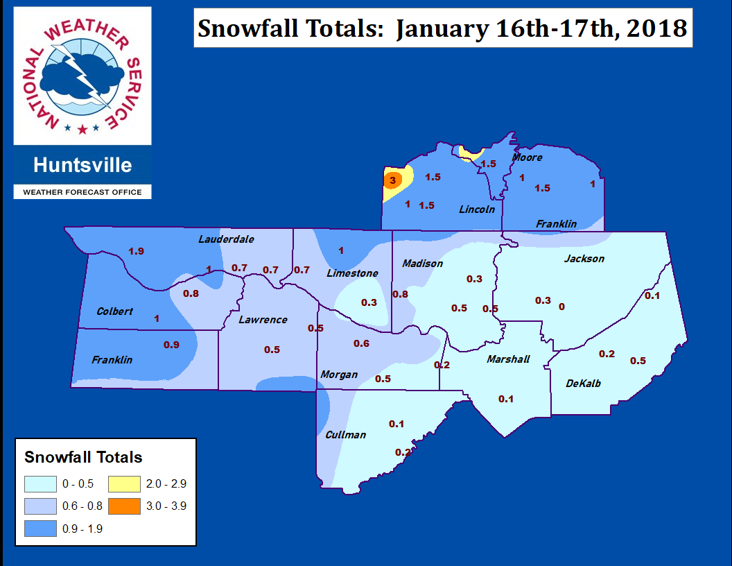