|
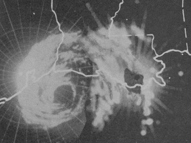
Above: Mosaic of MPS-7 23-cm weather radars from Ellington Air Force Base in Houston TX, England Air Force Base in Alexandria, LA, and Houma, LA at 6 AM CST on June 27, 1957. (Imagery courtesy of Texas A&M).
Just about everyone who lives in or grew up across Southern Louisiana and Southeast Texas knows the story of Hurricane Audrey, whether it was stories their parents or grandparents passed on, or literature they read within the history books.
Audrey formed in the Bay of Campeche early on June 24th, and attained tropical storm strength later that afternoon. This is based on the re-analysis data obtained by the ongoing Hurricane Re-Analysis Project of the Hurricane Research Division. Weather satellites were not launched yet, so the area and time of exact formation had to be estimated by ship reports and surface weather map analysis. When these reports were received by the U.S. Weather Bureau stations, reconnaissance aircraft investigated the system around noon June 25th, and found it was already a minimal hurricane. Hurricane Audrey slowly strengthened the next 24 hours reaching maximum sustained winds of 90 mph (80 knots), located some 200 miles east of Brownsville, TX around noon June 26th.
Audrey began the process of rapid intensification during the afternoon of June 26th, as well as increased northerly speed, as it approached the northern Gulf Coast. Maximum sustained winds increased to 105 mph (90 knots) by 6 PM CST, 115 mph (100 knots) by Midnight, and 125 mph (110 knots) by 6 AM CST June 27th while Audrey was just off the Southwest Louisiana coast.
Audrey made landfall between Sabine Pass and Johnsons Bayou, Louisiana around 7 AM CST June 27, 1957 as a strong category three hurricane with maximum sustained winds of 125 mph (110 knots) and a minimum central pressure of 946 millibars (27.94 inches). Audrey weakened after landfall, but due to the 15 mph northward forward speed, still had 90 mph (80 knots) maximum sustained winds across Beauregard Parish at Noon. A radar mosaic of MPS-7 23-cm weather radars from Ellington Air Force Base in Houston TX, England Air Force Base in Alexandria, LA, and Houma, LA on June 27, 1957 at 1 PM CST shows the large eye still well organized. Audrey finally weakened below hurricane intensity near Natchitoches by 6 PM CST, but remained a strong tropical storm across North Louisiana, with more pronounced weakening across Arkansas on June 28th. Click here for an interactive map of Hurricane Audrey.
Hurricane Audrey ranks as the 7th deadliest hurricane to strike the United States (3rd deadliest within Louisiana) in modern record keeping, with at least 500 deaths. The exact number will never be known, as many perished in the storm surge in Cameron and Vermilion parishes, and many missing persons were never found. Hurricane Audrey is also noted as being one of the strongest June hurricanes, and earliest major hurricane to make landfall across Louisiana, as well as the United States.
The city of of Cameron and Cameron Parish government hosted a memorial service on June 27th, 2007, dedicated to the victims of Hurricane Audrey. The National Weather Service Lake Charles, LA participated in this event with an informative booth highlighting various meteorological data from Hurricane Audrey. Many have compared the impacts of Hurricane Audrey with Hurricane Rita. Click here to see a meteorological comparison of these two historic hurricanes.
WIND & PRESSURE:
Audrey was a large hurricane that generated hurricane force wind gusts from Galveston and Beaumont in Southeast Texas eastward across Southwest, South Central and most of Central Louisiana. The highest wind gusts occurred across Cameron, Vermilion, Calcasieu, and Jeff Davis Parishes, as well as Jefferson and Orange Counties across Southeast Texas. The Weather Bureau in Lake Charles, Louisiana recorded a peak gust of 97 mph (84 knots) at 9:30 AM CST with a minimum sea level pressure of 971.4 millibars (28.69 inches) at 11:47 AM CST June 27th. Sulphur, Louisiana City Services reported a maximum wind gust of 105 mph at 9:40 AM CST with light winds and the passage of the eye at 11:05 AM CST. The Cameron, Louisiana Courthouse, one of the few remaining buildings standing in Cameron Parish, reported a minimum pressure of 959 millibars (28.32 inches), but no wind equipment was available. For complete meteorological statistics, see the Wind and Pressure section.
STORM SURGE:
Audrey spread a massive storm surge across most of Cameron parish, and across the southern halves of Calcasieu, Vermilion, Iberia, and St. Mary parishes, causing total devastation in property and many lives lost. The highest storm surge occurred across coastal Cameron parish, where high water marks of 12-14 feet MSL were found across Cameron, Creole, and Grand Chenier, and 10-12 feet MSL across the remainder of coastal Cameron parish. Further east across coastal Vermilion, Iberia, and St. Mary parishes, storm surge high water marks ranged from 8-11 feet MSL. Across Calcasieu parish, high water marks of 6-8 feet MSL were found along the Calcasieu river basin, extending across downtown Lake Charles. For other storm surge and high-water marks across our region, see the Storm Surge section.
RAINFALL:
Rainfall of 5-10 inches occurred across Southwest and Central Louisiana mainly east of where the eye of Audrey passed. The highest measured rainfall of 10.63 inches occurred 2 miles west of Basile, Louisiana. Elsewhere, 3-5 inches occurred across Southeast Texas and South Central Louisiana. For complete rainfall totals reported across our region, see the Rainfall section.
TORNADOES:
An F1 tornado was reported between Grand Coteau and Arnaudville, Louisiana around 10:30 PM CST on June 27th. For complete details on all the tornadoes reported, see the Tornadoes section.
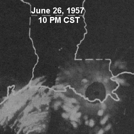
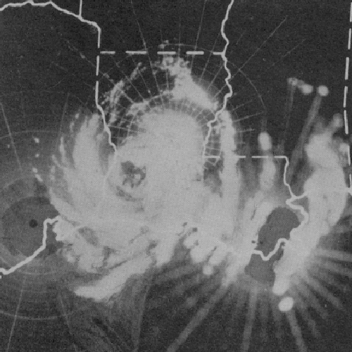
Above: Mosaic animation of MPS-7 radars from Ellington Air Force Base in Houston TX, England Air Force Base in Alexandria, LA, and Houma, LA from June 26, 1957 at 10 PM CST through June 27, 1957 at 9 PM CST. Even several hours after landfall, Audrey's eye is still intact over Beauregard Parish, some 60 miles inland. (Imagery courtesy of Texas A&M).
Original webpage design and content for 50th Anniversary: Donovan Landreneau, Sam Shamburger
Updated webpage design and content for 65th Anniversary: Donovan Landreneau
|

