|
Fast Facts
|
|
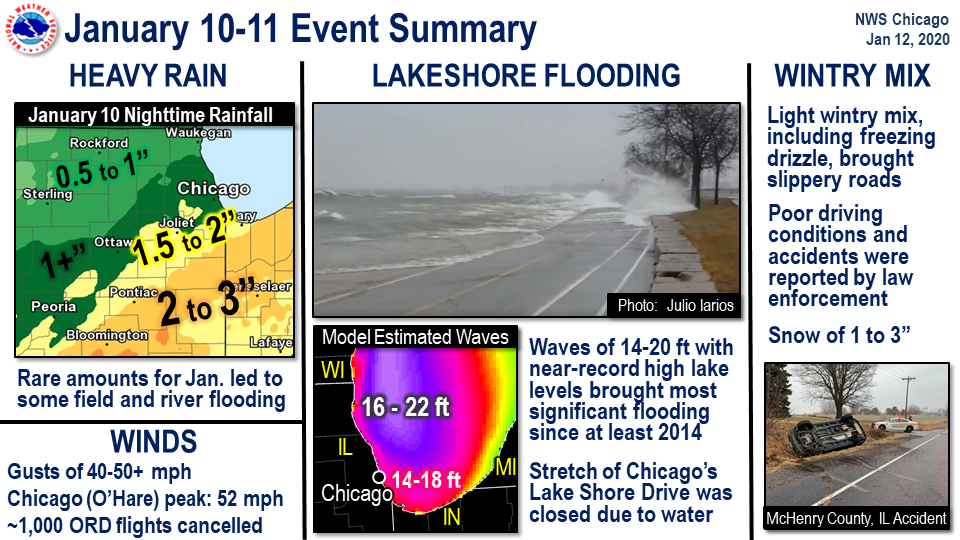
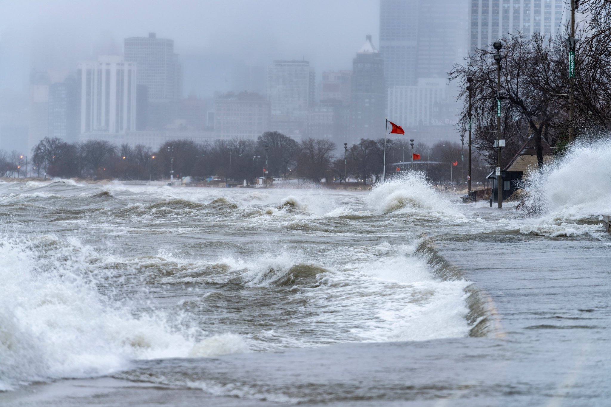
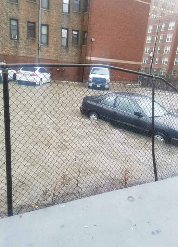
Lakeshore Flooding
 |
 |
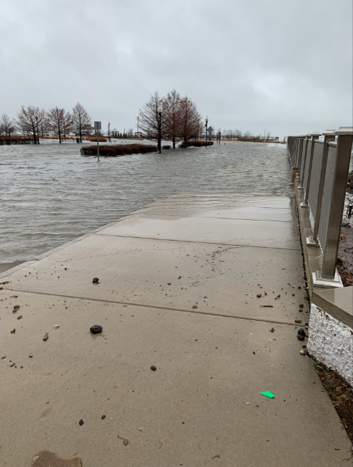 |
| Chicago, IL on Jan 11. Photo courtesy of Matt Zuro. | Near South Shore Drive in Chicago, IL on Jan 11. Photo courtesy of Bill Snyder. | Whihala Beach in Whiting, IN. Photo courtesy of Deb Mann. |
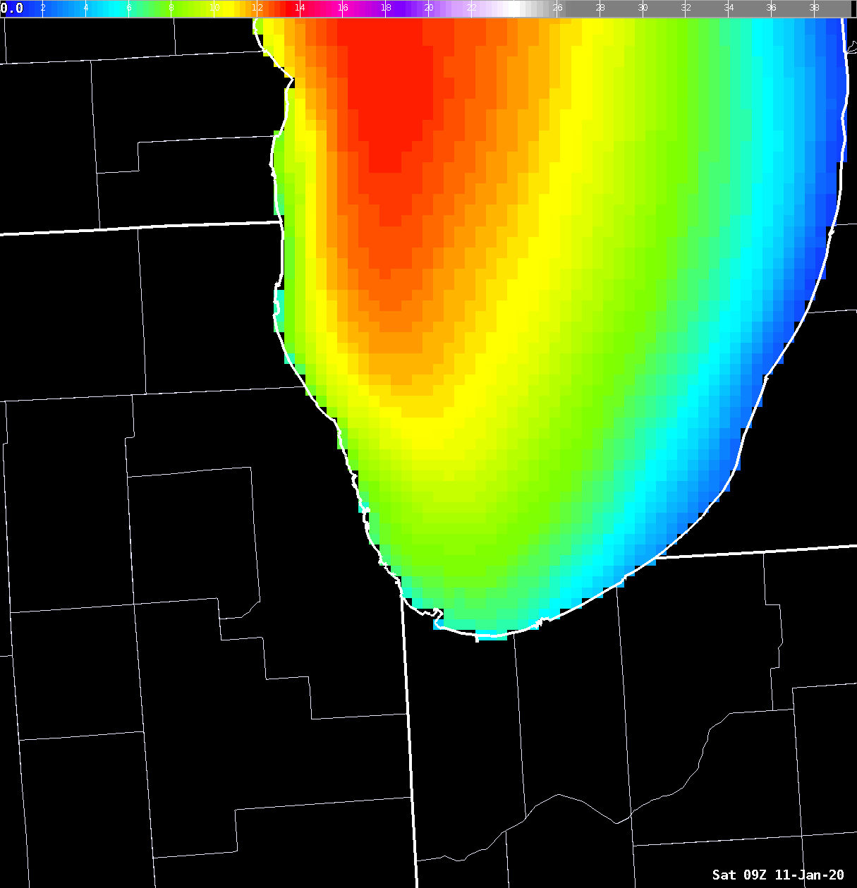 |
| Hourly loop of modeled wave heights from 3 a.m. through 7 p.m. on January 11. |
Winds
Public Information Statement
National Weather Service Chicago IL
426 AM CST Sun Jan 12 2020 /526 AM EST Sun Jan 12 2020/

...HIGHEST WIND GUSTS ON SATURDAY JANUARY 11...

Observations are collected from a variety of sources with varying
equipment and exposures. Not all data listed are considered
official.

Land Location                Speed     Time/Date
----------------------------------------------------
Waukegan Airport             54 MPH    0755 AM 01/11
Chicago O`Hare               52 MPH    0938 AM 01/11
Chicago Midway               51 MPH    0935 AM 01/11
West Chicago - DuPage Arpt.  49 MPH    0720 AM 01/11
Wheeling - Chicago Exec. Arp 49 MPH    0921 AM 01/11
Gary Airport                 48 MPH    1245 PM 01/11
Kankakee Airport             44 MPH    1015 AM 01/11
Sugar Grove - Aurora Arpt.   43 MPH    0636 AM 01/11
Romeoville - Lewis Airport   43 MPH    0735 AM 01/11
Valparaiso Airport           43 MPH    1209 PM 01/11
DeKalb Airport               41 MPH    0715 AM 01/11
Rockford Airport             40 MPH    0732 AM 01/11
Lansing Airport              39 MPH    0735 AM 01/11
Joliet Airport               38 MPH    0635 AM 01/11
Rochelle Airport             37 MPH    0815 AM 01/11
Pontiac Airport              36 MPH    1015 AM 01/11
Peru Airport                 35 MPH    0715 AM 01/11


Marine Location              Speed     Time/Date
----------------------------------------------------
2 NE Navy Pier               51 MPH    0830 AM 01/11
Calumet Harbor, IL           43 MPH    0842 AM 01/11
Heavy Rainfall
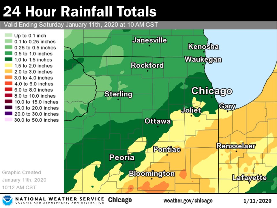 |
| Rainfall Totals from Friday Night, January 10 into early Saturday, January 11 |
Public Information Statement
National Weather Service Chicago IL
0950 AM CST Sat Jan 11 2020

...Morning Rainfall Roundup...

   The following are rain amounts for the previous 24-hours
   as measured in the morning by NWS Cooperative Observers
   and CoCoRaHS observers.
   Observations are usually taken between 6 AND 8 AM.

   24-hour rainfall amounts
       for Saturday(01/11/20)...


Illinois                                       Rain
  Location (County):                           fall (inches)

  Chatsworth (Livingston)......................2.97
  Marseilles Lock & Dam (La Salle).............2.91
  Chatsworth (Livingston)......................2.75
  Kankakee (Kankakee)..........................2.69
  Herscher 3E (Kankakee).......................2.69
  Crete 3E (Will)..............................2.62
  St Anne (Kankakee)...........................2.62
  Ashkum 5.6E (Iroquois).......................2.57
  Gibson 3WNW (Ford)...........................2.51
  Bourbonnais (Kankakee).......................2.46
  Pontiac 1SE (Livingston).....................2.45
  Peotone (Will)...............................2.34
  Beecher 3ENE (Will)..........................2.27
  Lansing (Cook)...............................2.21
  Oak Lawn (Cook)..............................2.07
  Park Forest (Cook)...........................2.00
  Watseka 6.9WNW (Iroquois)....................1.99
  Chicago 6ESE (Cook)..........................1.97
  Flossmoor 1ESE (Cook)........................1.97
  Manhattan 2SE (Will).........................1.95
  Lansing (Cook)...............................1.94
  Wilmington 3SE (Will)........................1.94
  Pontiac (Livingston).........................1.88
  Homewood (Cook)..............................1.85
  Paxton (Ford)................................1.85
  Midway Coop (Cook)...........................1.80
  Bridgeview 1NNW (Cook).......................1.78
  New Lenox 3E (Will)..........................1.77
  Dwight (Livingston)..........................1.75
  Palos Park 1SW (Cook)........................1.75
  Oak Lawn 2SE (Cook)..........................1.74
  Minooka (Grundy).............................1.74
  Manhattan 5ENE (Will)........................1.74
  Manhattan (Will).............................1.74
  Chicago Ridge (Cook).........................1.73
  Oak Lawn 2WNW (Cook).........................1.73
  Midlothian (Cook)............................1.72
  Countryside 1ENE (Cook)......................1.70
  Mazon 0.5ENE (Grundy)........................1.65
  Joliet 3WNW (Will)...........................1.64
  Plainfield 3ESE (Will).......................1.62
  New Lenox 2SE (Will).........................1.62
  Morris (Grundy)..............................1.61
  Cissna Park 1S (Iroquois)....................1.57
  Coal City 4NNW (Grundy)......................1.56
  Carbon Hill 3.1N (Grundy)....................1.56
  Morris 5NNW (Grundy).........................1.56
  Park Forest 1NNE (Cook)......................1.55
  Oswego 5SSE (Kendall)........................1.54
  Channahon 2SSE (Will)........................1.54
  Lockport 1SE (Will)..........................1.54
  Coal City 3N (Grundy)........................1.52
  Joliet 2n (Will).............................1.51
  Willow Springs (Cook)........................1.51
  Morris 6ESE (Grundy).........................1.50
  Brandon Road Lock & Dam (Will)...............1.50
  Homer Glen 2NW (Will)........................1.49
  Somonauk 2NE (De Kalb).......................1.48
  Plainfield 2SSE (Will).......................1.48
  Romeoville (Will)............................1.46
  Ottawa 1NW (La Salle)........................1.45
  Oak Park 2S (Cook)...........................1.42
  Elk Grove Village 2WSW (Cook)................1.42
  Downers Grove 0.4NNE (Du Page)...............1.42
  Naperville 4SSW (Will).......................1.42
  Midway (Cook)................................1.42
  Ottawa 2N (La Salle).........................1.41
  Glen Ellyn 2SSE (Du Page)....................1.40
  Naperville 2SE (Du Page).....................1.40
  Wilmington 6NW (Will)........................1.40
  Ottawa (La Salle)............................1.40
  Harwood Heights (Cook).......................1.39
  Bolingbrook 3NE (Du Page)....................1.39
  Plainfield 5SW (Kendall).....................1.39
  Geneva 4WSW (Kane)...........................1.39
  Oak Park 1NNE (Cook).........................1.38
  Naperville 2ESE (Du Page)....................1.38
  La Salle (La Salle)..........................1.38
  Streator (Livingston)........................1.37
  Burr Ridge 2SW (Du Page).....................1.36
  Sugar Grove 1NE (Kane).......................1.36
  Geneva 1SSW (Kane)...........................1.36
  Elburn (Kane)................................1.35
  Morris 2SSE (Grundy).........................1.34
  Batavia 1WNW (Kane)..........................1.34
  Streator 1WSW (La Salle).....................1.34
  Aurora 4SE (Du Page).........................1.33
  Villa Park 1NW (Du Page).....................1.33
  North Aurora 2NE (Kane)......................1.33
  Joliet (Will)................................1.33
  Batavia (Kane)...............................1.32
  Elmhurst 2SE (Du Page).......................1.32
  Batavia 2WNW (Kane)..........................1.32
  Hoffman Estates 5W (Cook)....................1.31
  Montgomery 1SSE (Kendall)....................1.31
  Romeoville (Will)............................1.31
  Rogers Park 2SW (Cook).......................1.30
  Paw Paw (Lee)................................1.30
  Aurora 4SE (Du Page).........................1.29
  Lincolnwood 2E (Cook)........................1.28
  La Grange Park 1SSW (Cook)...................1.28
  Glen Ellyn 1WSW (Du Page)....................1.28
  St. Charles (Kane)...........................1.28
  Morris (Grundy)..............................1.27
  Elgin (Kane).................................1.26
  Coal City (Grundy)...........................1.26
  Batavia 1WSW (Kane)..........................1.24
  Aurora (Kane)................................1.23
  Elmhurst 1ESE (Du Page)......................1.23
  Peru 1ENE (La Salle).........................1.23
  Wheaton 2NNE (Du Page).......................1.21
  St. Charles 6NW (Kane).......................1.21
  Sugar Grove 1ENE (Kane)......................1.20
  Schaumburg 2E (Cook).........................1.19
  Aurora (Kane)................................1.18
  Elgin (Kane).................................1.18
  Elgin 1S (Kane)..............................1.18
  Elmhurst (Du Page)...........................1.17
  West Chicago (Du Page).......................1.16
  Park Ridge (Cook)............................1.16
  Riverwoods (Lake)............................1.16
  Elk Grove Village 1ESE (Cook)................1.15
  Ohare Airport (Cook).........................1.14
  Westmont (Du Page)...........................1.14
  Hoffman Estates 2SE (Cook)...................1.12
  Park Ridge 1WNW (Cook).......................1.10
  Mount Prospect 3NE (Cook)....................1.10
  Buffalo Grove 2N (Lake)......................1.08
  Highwood 1S (Lake)...........................1.08
  Rockford 3NE (Winnebago).....................1.08
  Elgin 2W (Kane)..............................1.07
  Mundelein (Lake).............................1.07
  Palatine 1E (Cook)...........................1.04
  Lake Zurich (Lake)...........................1.04
  Genoa (De Kalb)..............................1.02
  Lake Bluff 1W (Lake).........................1.02
  Waukegan 2N (Lake)...........................1.02
  Wheeling (Cook)..............................1.00
  Schaumburg (Du Page).........................0.98
  Earlville 5NNE (De Kalb).....................0.98
  De Kalb (De Kalb)............................0.97
  Lombard 1NNW (Du Page).......................0.95
  DeKalb (De Kalb).............................0.93
  De Kalb 1SW (De Kalb)........................0.92
  Rockford 2ENE (Winnebago)....................0.92
  Palatine 1NNE (Cook).........................0.91
  Earlville 3S (La Salle)......................0.90
  Lake Villa 1SSW (Lake).......................0.90
  Lake Villa 2WSW (Lake).......................0.90
  Mendota (La Salle)...........................0.88
  Waukegan (Lake)..............................0.87
  Sterling 4NE (Lee)...........................0.86
  Woodstock 4SW (McHenry)......................0.83
  Mundelein (Lake).............................0.82
  Rockford (Winnebago).........................0.78
  Peru (La Salle)..............................0.78
  Bull Valley 2WNW (McHenry)...................0.77
  Crystal Lake 1WSW (McHenry)..................0.74
  Capron (Boone)...............................0.70
  Woodstock 5nw (McHenry)......................0.67
  Dekalb (De Kalb).............................0.65
  Rochelle (Ogle)..............................0.49
  Steward (Lee)................................0.46

Indiana                                        Rain
  Location (County):                           fall (inches)

  Hebron 4NE (Porter)..........................3.04
  Valparaiso 4SW (Porter)......................2.95
  Valparaiso 6SSW (Porter).....................2.90
  De Motte 1SSW (Jasper).......................2.80
  Valparaiso 2WSW (Porter).....................2.80
  Valparaiso 1NNW (Porter).....................2.78
  Schererville 1E (Lake).......................2.66
  Valparaiso (Porter)..........................2.64
  Crown Point (Lake)...........................2.63
  De Motte 1NNW (Jasper).......................2.63
  Crown Point 1N (Lake)........................2.63
  Dyer 1WNW (Lake).............................2.54
  St. John (Lake)..............................2.47
  De Motte 4SW (Jasper)........................2.40
  Portage 3E (Porter)..........................2.40
  Gary 5ENE (Lake).............................2.39
  Porter 1S (Porter)...........................2.39
  De Motte 6S (Jasper).........................2.30
  Mount Ayr 2NNE (Newton)......................2.19
  Morocco (Newton).............................2.15
  Kentland 2SSE (Newton).......................2.12
  Rensselaer (Jasper)..........................2.12
  Hammond 1SSW (Lake)..........................2.10
  Rensselaer 2SSW (Jasper).....................2.05
  Kentland (Newton)............................1.87
  Remington (Jasper)...........................1.86
Storm Reports
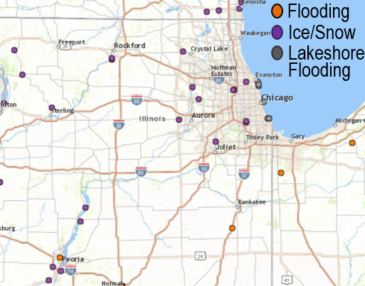 |
| Storm Reports |
PRELIMINARY LOCAL STORM REPORT...SUMMARY
NATIONAL WEATHER SERVICE CHICAGO IL
437 AM CST SUN JAN 12 2020

..TIME...   ...EVENT...      ...CITY LOCATION...     ...LAT.LON...
..DATE...   ....MAG....      ..COUNTY LOCATION..ST.. ...SOURCE....
            ..REMARKS..

0400 AM     SNOW             CRYSTAL LAKE            42.26N 88.40W
01/12/2020  M1.5 INCH        MCHENRY            IL   CO-OP OBSERVER


1205 AM     SNOW             ROCKFORD AIRPORT        42.20N 89.10W
01/12/2020  M2.1 INCH        WINNEBAGO          IL   OFFICIAL NWS OBS


1200 AM     SNOW             NWS CHICAGO-ROMEOVILLE  41.60N 88.08W
01/12/2020  E0.4 INCH        WILL               IL   OFFICIAL NWS OBS


1200 AM     SNOW             3 SW MIDWAY AIRPORT     41.74N 87.78W
01/12/2020  E1.2 INCH        COOK               IL   CO-OP OBSERVER


1200 AM     SNOW             OHARE AIRPORT           41.98N 87.90W
01/12/2020  M2.1 INCH        COOK               IL   OFFICIAL NWS OBS

            LIQUID EQUIVALENT OF 0.06 IN.

1100 PM     SNOW             MORTON GROVE            42.04N 87.78W
01/11/2020  M1.8 INCH        COOK               IL   BROADCAST MEDIA


1046 PM     SNOW             1 NW SOUTH ELGIN        42.00N 88.31W
01/11/2020  M1.3 INCH        KANE               IL   PUBLIC


0600 PM     FREEZING RAIN    DUPAGE AIRPORT          41.91N 88.25W
01/11/2020  M0.04 INCH       DUPAGE             IL   ASOS


0600 PM     FREEZING RAIN    SUGAR GROVE             41.76N 88.44W
01/11/2020  M0.03 INCH       KANE               IL   ASOS

            MEASURED AT AURORA AIRPORT ASOS.

0200 PM     LAKESHORE FLOOD  CHICAGO                 41.89N 87.61W
01/11/2020                   COOK               IL   BROADCAST MEDIA

            ASPHALT ON CHICAGO BIKE PATH ALONG THE LAKE
            SHORE DAMAGED AT OHIO STREET BEACH DUE TO
            BATTERING HIGH WAVES.

0110 PM     LAKESHORE FLOOD  6 SSE SOUTH CHICAGO     41.77N 87.56W
01/11/2020                   COOK               IL   BROADCAST MEDIA

            WATER AS MUCH AS 400 FT INLAND WEST OF LAKE
            MICHIGAN SHORE. WATER SEVERAL INCHES DEEP
            OVER 72ND STREET AND ONTO PROPERTIES THAT
            ARE ALONG THE ROAD.

1200 PM     FREEZING RAIN    ROCKFORD AIRPORT        42.20N 89.10W
01/11/2020  M0.25 INCH       WINNEBAGO          IL   ASOS


1200 PM     LAKESHORE FLOOD  1 NNE ROGERS PARK       42.02N 87.66W
01/11/2020                   COOK               IL   PUBLIC

            VIDEO SHARED BY PUBLIC VIA SOCIAL MEDIA OF
            WAVES REACHING RESIDENTIAL STRUCTURES ALONG
            EASTLAKE TERRACE IN ROGERS PARK
            NEIGHBORHOOD.

1200 PM     LAKESHORE FLOOD  1 ESE EVANSTON          42.04N 87.67W
01/11/2020                   COOK               IL   PUBLIC

            VIDEO SHARED BY PUBLIC VIA SOCIAL MEDIA
            SHOWS ELLIOT PARK INUNDATED BY LAKE
            MICHIGAN.

1155 AM     HEAVY RAIN       CEDAR LAKE              41.37N 87.44W
01/11/2020  M3.15 INCH       LAKE               IN   PUBLIC


1030 AM     LAKESHORE FLOOD  2 NNW SOUTH CHICAGO     41.77N 87.56W
01/11/2020                   COOK               IL   PUBLIC

            PHOTO SHARED BY PUBLIC VIA SOCIAL MEDIA
            SHOWS LAKE MICHIGAN FLOOD INUNDATION HAS
            REACHED SOUTH SHORE DRIVE AT 72ND STREET.

0930 AM     FLOOD            2 NNE CLIFTON           40.96N 87.92W
01/11/2020                   IROQUOIS           IL   EMERGENCY MNGR

            IROQUOIS COUNTY EMERGENCY MANAGER REPORTS
            FLOODING AT OLD US-45 NORTH OF 3100 NORTH
            ROAD.

0900 AM     LAKESHORE FLOOD  1 ESE ROGERS PARK       42.01N 87.66W
01/11/2020                   COOK               IL   PUBLIC

            VIDEO SHARED BY PUBLIC OVER SOCIAL MEDIA OF
            LARGE PORTIONS OF LOYOLA BEACH INUNDATED BY
            LAKESHORE FLOODING INCLUDING SIDEWALKS AND
            PORTIONS OF THE BREAKWALL.

0820 AM     FREEZING RAIN    WINNEBAGO               42.27N 89.24W
01/11/2020  M0.25 INCH       WINNEBAGO          IL   TRAINED SPOTTER

            QUARTER INCH OF ICE ACCUMULATION ON TREES.
            THIN LAYER OF ICE ON PAVEMENT. LOST POWER
            BRIEFLY OVERNIGHT.

0730 AM     FLOOD            3 NNW PONTIAC           40.92N 88.64W
01/11/2020                   LIVINGSTON         IL   PUBLIC

            PHOTO SHARED BY PUBLIC OVER SOCIAL MEDIA OF
            FLOODED AGRICULTURAL LAND AND POSSIBLY SOME
            RURAL ROADS NEAR I-55 AND IL-23.

0730 AM     FLOOD            CHATSWORTH              40.75N 88.29W
01/11/2020                   LIVINGSTON         IL   CO-OP OBSERVER

            COOPERATIVE OBSERVER REPORTS MINOR FLOODING
            OF AGRICULTURAL FIELDS IN THE CHATSWORTH
            AREA.

0715 AM     HEAVY RAIN       PARK FOREST             41.48N 87.69W
01/11/2020  M2.01 INCH       COOK               IL   TRAINED SPOTTER


0700 AM     HEAVY RAIN       JOLIET                  41.53N 88.08W
01/11/2020  E1.58 INCH       WILL               IL   PUBLIC


0500 AM     HEAVY RAIN       BONFIELD                41.15N 88.06W
01/11/2020  E2.38 INCH       KANKAKEE           IL   PUBLIC

            VIA SOCIAL MEDIA.
Snowfall and Forecast Points
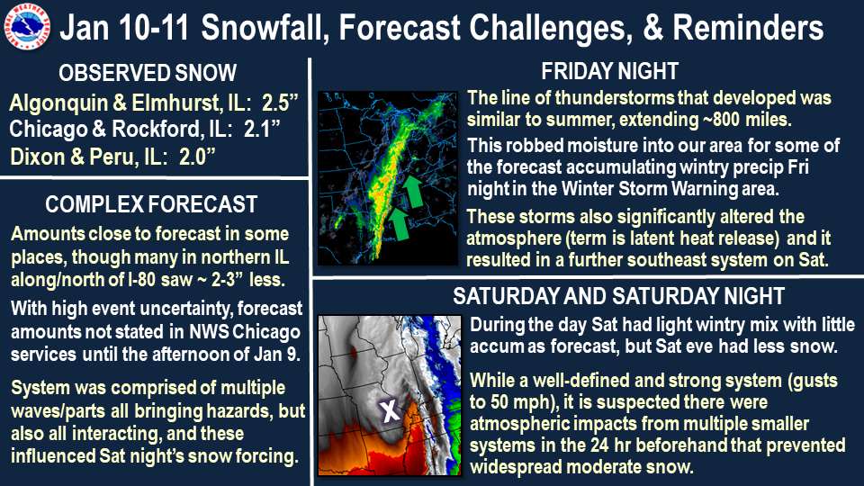 |
| Snowfall Amounts and Forecast Challenges |
Public Information Statement
National Weather Service Chicago IL
1001 AM CST Sun Jan 12 2020

...Morning Snowfall Roundup...

   The following are snow amounts for the previous 24 hours
   as measured in the morning by NWS Cooperative Observers
   and CoCoRaHS observers.
   Observations are usually taken at 7 AM.

   24-hour Snowfall Amounts for Sunday(01/12/20)...


Northern Illinois                              Snow
  Location (County):                           fall(inches)

  Elmhurst (Du Page)............................2.5
  Algonquin 1N (McHenry)........................2.5
  Capron (Boone)................................2.1
  Ohare Airport (Cook)..........................2.1
  Rockford (Winnebago)..........................2.1
  Somonauk 2NE (De Kalb)........................2.0
  Dixon 3NNW (Lee)..............................2.0
  Waukegan 2N (Lake)............................2.0
  Peru 1ENE (La Salle)..........................2.0
  Mundelein (Lake)..............................2.0
  Harwood Heights (Cook)........................1.9
  Oak Park 1NNE (Cook)..........................1.9
  Bull Valley 2WNW (McHenry)....................1.9
  Lincolnwood 2E (Cook).........................1.8
  Downers Grove 0.4NNE (Du Page)................1.8
  Genoa (De Kalb)...............................1.7
  Hoffman Estates 5W (Cook).....................1.7
  Roselle 1ESE (Du Page)........................1.7
  La Salle (La Salle)...........................1.7
  Oak Park 2S (Cook)............................1.6
  Rogers Park 2SW (Cook)........................1.6
  Wonder Lake 1WNW (McHenry)....................1.6
  Oak Lawn (Cook)...............................1.5
  Park Ridge (Cook).............................1.5
  Hoffman Estates 2SE (Cook)....................1.5
  Buffalo Grove 2N (Lake).......................1.5
  Rockford 3NE (Winnebago)......................1.5
  Rockford 6S (Winnebago).......................1.5
  Rockford 1NW (Winnebago)......................1.4
  Elmhurst 1ESE (Du Page).......................1.3
  Geneva 4WSW (Kane)............................1.3
  Geneva 1SSW (Kane)............................1.3
  Mundelein (Lake)..............................1.2
  Elgin 2W (Kane)...............................1.2
  Midway Coop (Cook)............................1.2
  Bridgeview 1NNW (Cook)........................1.1
  Park Ridge 1WNW (Cook)........................1.1
  Burr Ridge 2SW (Du Page)......................1.1
  Ottawa 2N (La Salle)..........................1.1
  Crystal Lake 1WSW (McHenry)...................1.1
  Lake Zurich (Lake)............................1.1
  Palatine 1E (Cook)............................1.0
  Chicago Ridge (Cook)..........................1.0
  Elk Grove Village 2WSW (Cook).................1.0
  De Kalb 1SW (De Kalb).........................1.0
  Wheaton 2NNE (Du Page)........................1.0
  Riverwoods (Lake).............................1.0
  Woodstock 4SW (McHenry).......................1.0
  Ottawa (La Salle).............................1.0
  Willow Springs (Cook).........................1.0
  Palatine 1NNE (Cook)..........................0.9
  St. Charles 6NW (Kane)........................0.9
  Plainfield 2SSE (Will)........................0.9
  Batavia (Kane)................................0.8
  Elgin (Kane)..................................0.8
  Hebron (McHenry)..............................0.8
  Countryside 1ENE (Cook).......................0.8
  Bolingbrook 3NE (Du Page).....................0.8
  Batavia 1WNW (Kane)...........................0.8
  Lockport 1SE (Will)...........................0.8
  Barrington (Lake).............................0.7
  Elk Grove Village 1ESE (Cook).................0.7
  Sugar Grove 1NE (Kane)........................0.7
  Batavia 2WNW (Kane)...........................0.7
  Crete 3E (Will)...............................0.7
  Paw Paw (Lee).................................0.7
  DeKalb (De Kalb)..............................0.6
  Streator 1WSW (La Salle)......................0.6
  New Lenox 2SE (Will)..........................0.6
  Chicago 6ESE (Cook)...........................0.5
  Palos Park 1SW (Cook).........................0.5
  New Lenox 3E (Will)...........................0.5
  Manhattan (Will)..............................0.5
  Park Forest (Cook)............................0.5
  Ottawa 1NW (La Salle).........................0.4
  Romeoville (Will).............................0.4
  Mendota (La Salle)............................0.4
  Joliet 2n (Will)..............................0.3
  Coal City 4NNW (Grundy).......................0.2
  Park Forest 1NNE (Cook).......................0.2
  Aurora 4SE (Du Page)..........................0.2
  Naperville 2SE (Du Page)......................0.2
  Carbon Hill 3.1N (Grundy).....................0.2
  Montgomery 1SSE (Kendall).....................0.2
  Bourbonnais (Kankakee)........................0.1
  Watseka 6.9WNW (Iroquois).....................0.1
  Herscher 3E (Kankakee)........................0.1
  Streator (Livingston).........................0.1
  Ashkum 5.6E (Iroquois)......................TRACE
  Chatsworth (Livingston).....................TRACE
  Peotone (Will)..............................TRACE
  Momence (Kankakee)..........................TRACE
  Morris (Grundy).............................TRACE
  Peotone (Will)..............................TRACE
  St Anne (Kankakee)..........................TRACE
  Steward (Lee)...............................TRACE

Northwest Indiana                              Snow
  Location (County):                           fall(inches)

  Valparaiso 1NNW (Porter)......................0.6
  Crown Point (Lake)............................0.5
  Dyer 1WNW (Lake)..............................0.3
  Valparaiso 6SSW (Porter)......................0.3
  Valparaiso 4SW (Porter).......................0.2
  Hebron 4NE (Porter)...........................0.2
  Porter 1S (Porter)............................0.2
  Rensselaer (Jasper)...........................0.2
  Gary 5ENE (Lake)..............................0.1
  Crown Point 1N (Lake).........................0.0
  Rensselaer 2SSW (Jasper)....................TRACE
  De Motte 6S (Jasper)........................TRACE
  De Motte 4SW (Jasper).......................TRACE
  Mount Ayr 2NNE (Newton).....................TRACE
  Morocco (Newton)............................TRACE
Links
 |
Media use of NWS Web News Stories is encouraged! Additional recaps can be found on the NWS Chicago Science & Past Events Page. |
|