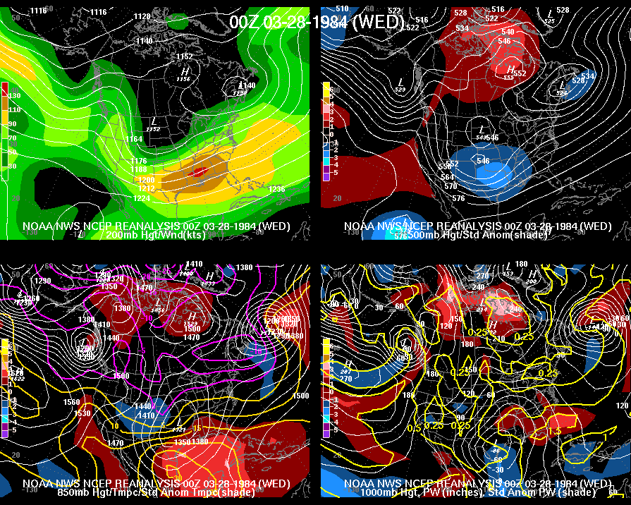
| The Carolinas Outbreak of March 28, 1984 was one of the deadliest, most destructive tornado outbreaks in the history of the two Carolinas. The weather situation that produced this outbreak has strong parallels to the 1925 Tri-State Tornado Outbreak in that the tornadoes tracked along with the center of a strong low pressure system. The only other local events with a similar size and scope were the Enigma Outbreak of February 19-20, 1884 which killed least 50 people in North and South Carolina, and the April 16, 2011 outbreak which produced 30 confirmed tornadoes in North Carolina alone. The statistics of this outbreak are staggering and perhaps unprecedented in the history of North or South Carolina. The final count shows 24 individual tornadoes touched down: 11 in North Carolina, 11 in South Carolina, and 2 in Georgia. The human impact included 57 fatalities, (42 in North Carolina, 15 in South Carolina, none in Georgia) and 1248 injuries. (799 in North Carolina, 448 in South Carolina, and 1 in Georgia) 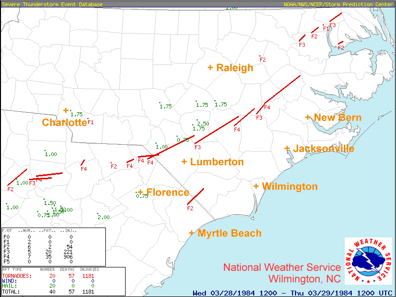  Meteorological History During the evening of March 27, 1984 strong surface low pressure was already present across Texas. A broad upper level trough across the southern Rocky Mountains was moving out into the Plains states just behind the surface low. Surface pressures were anomalously low across a large area of the southern Plains into the lower Mississippi valley surrounding a warm front just inland from the Gulf coast. This warm front surged north overnight into the morning of March 28th as the low moved northeast to near Memphis, TN. Very warm, humid air was pulled northward from the Gulf of Mexico, while the mid and upper levels of the atmosphere were cooling due to the approaching upper level trough moving east out of the Plains states. This created a very unstable situation across Georgia and the Carolinas during the afternoon of March 28th.    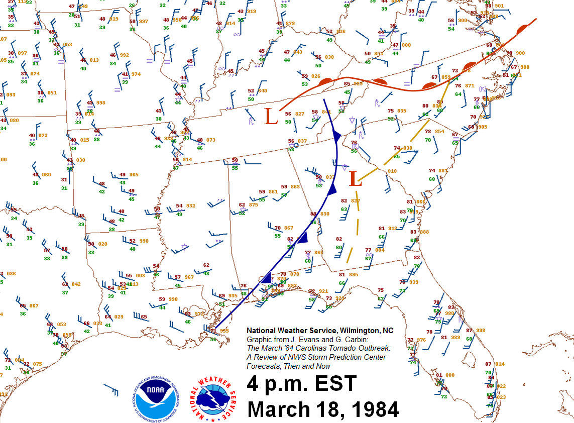 The original surface low moved into eastern Tennessee during the afternoon, while a new small surface low developed in northern Alabama along the warm front. A cluster of thunderstorms developed near this new low, aided by surface temperatures surging to 80 degrees or warmer along and south of the warm front. As the new low strengthened and moved northeast into the Carolinas, winds spiraling into the low pressure increased in speed across the central and eastern Carolinas and became more solidly from the south rather than southwest. Since the thunderstorms were moving rapidly northeastward with the main atmospheric flow, winds blowing from the south at the surface created a strongly sheared environment supportive of rotating supercell thunderstorms.  Forecasters at the NWS SELS office (Severe Local Storms Unit, the forerunner of today's Storm Prediction Center) were closely monitoring the situation. Earlier on the morning of the 28th, the SELS Convective Outlook depicted a Moderate Risk of severe thunderstorms covering virtually all of Georgia and the Carolinas. As the day progressed, forecasters noted strong thunderstorm development with the new surface low was following a developing surface trough of low pressure just south of the front extending northeastward into the Carolinas. This trough axis marked the zone of strongest convergence of winds in the lowest portion of the atmosphere. Instability also increased during the afternoon, with CAPE (Convective Available Potential Energy) rising into the 2000 to 3000 J/kg range. Armed with this information, SELS forecasters issued a tornado watch for the Eastern Carolinas, and took the then-unprecedented step of upgrading the severe thunderstorm outlook to HIGH RISK across Georgia and the Eastern Carolinas, the first time in history this area had been placed under such an extreme severe weather outlook. The outlook itself read in part, Forecasters at the NWS SELS office (Severe Local Storms Unit, the forerunner of today's Storm Prediction Center) were closely monitoring the situation. Earlier on the morning of the 28th, the SELS Convective Outlook depicted a Moderate Risk of severe thunderstorms covering virtually all of Georgia and the Carolinas. As the day progressed, forecasters noted strong thunderstorm development with the new surface low was following a developing surface trough of low pressure just south of the front extending northeastward into the Carolinas. This trough axis marked the zone of strongest convergence of winds in the lowest portion of the atmosphere. Instability also increased during the afternoon, with CAPE (Convective Available Potential Energy) rising into the 2000 to 3000 J/kg range. Armed with this information, SELS forecasters issued a tornado watch for the Eastern Carolinas, and took the then-unprecedented step of upgrading the severe thunderstorm outlook to HIGH RISK across Georgia and the Eastern Carolinas, the first time in history this area had been placed under such an extreme severe weather outlook. The outlook itself read in part,
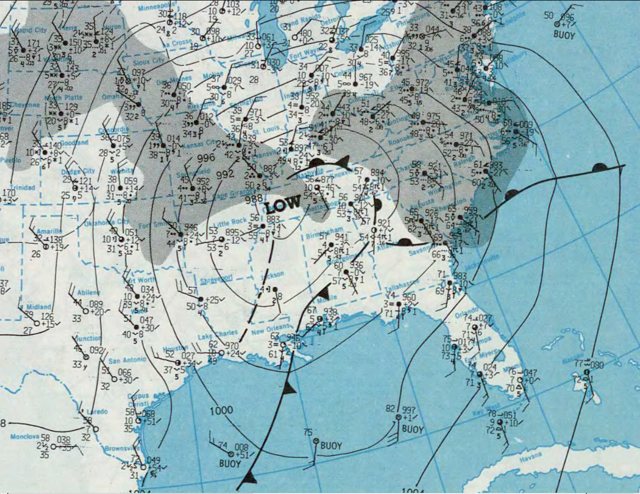
HIGH RISK ISSUED FOR AL...GA...SC...NC(Note: as of early 2013, only four outlooks have ever used the High Risk category across North Carolina)  Tornadoes began touching down in Upstate South Carolina during the late afternoon hours of March 28th. Thunderstorms located essentially in the middle of the low pressure center followed the surface trough northeastward during the evening, passing between Columbia and Charlotte around 6 p.m., and approaching Fayetteville by 8 p.m. Multiple long-tracked tornadoes occurred across the Sandhills and then the North Carolina Coastal Plain, mercifully ending around 10 p.m. north of the Albemarle Sound in northeastern North Carolina. Tornadoes began touching down in Upstate South Carolina during the late afternoon hours of March 28th. Thunderstorms located essentially in the middle of the low pressure center followed the surface trough northeastward during the evening, passing between Columbia and Charlotte around 6 p.m., and approaching Fayetteville by 8 p.m. Multiple long-tracked tornadoes occurred across the Sandhills and then the North Carolina Coastal Plain, mercifully ending around 10 p.m. north of the Albemarle Sound in northeastern North Carolina.Selected Tornado Reports from March 28, 1984 Ware Shoals and Laurens County, SC: Up to 50 injuries with F1 and F2 tornado touchdowns between 4:00 and 5:00 p.m. Town of Newberry, Newberry County, and Fairfield County, SC: F2 and F3 tornadoes between 5:00 and 5:40 p.m. caused two deaths and 50 injuries along with $14 million in property damage. Downtown Newberry, SC "looked like a war zone." Lancaster, Kershaw, and Chesterfield Counties, SC: Four tornadoes occurred (one F2 and three F4 twisters) in a line across the Eastern Piedmont into the Sandhills of northern South Carolina. There were six deaths and over 100 injuries across the Winnsboro, Kershaw and Cash communities. Extensive forested areas were damaged in the Sandhills NWR. Union County, NC: Ten miles north of Monroe a tornado (F1) touched down briefly. One mobile home and one garage were destroyed and two mobile homes were damaged. No one was injured.  Marlboro, Scotland, Robeson and Cumberland Counties: Between 6:40 and 7:40 p.m. two F4 tornadoes tore long paths across the area, killing 12 people and injuring 495. One tornado affected mainly Marlboro County with significant damage around Bennettsville, SC. After hitting McColl, SC, the second tornado (a monster F4) crossed into NC and continued along the ground for 35 miles before lifting in Southern Cumberland County. The storm hit Maxton at 7:30 p.m. EST and Red Springs 10 minutes later. This tornado was 2.5 miles wide at one point. The storm killed 3 and injured 280 in Robeson County alone, mainly in Maxton and Red Springs. Damage exceeded $500,000. Marlboro, Scotland, Robeson and Cumberland Counties: Between 6:40 and 7:40 p.m. two F4 tornadoes tore long paths across the area, killing 12 people and injuring 495. One tornado affected mainly Marlboro County with significant damage around Bennettsville, SC. After hitting McColl, SC, the second tornado (a monster F4) crossed into NC and continued along the ground for 35 miles before lifting in Southern Cumberland County. The storm hit Maxton at 7:30 p.m. EST and Red Springs 10 minutes later. This tornado was 2.5 miles wide at one point. The storm killed 3 and injured 280 in Robeson County alone, mainly in Maxton and Red Springs. Damage exceeded $500,000.Bladen, Cumberland, and Sampson Counties: A tornado (F3) touched down 5 miles northeast of Tobermory in northwestern Bladen County and travelled along the ground through Cumberland and Sampson counties. The path was 0.8 miles wide and 40 miles long. The tornado struck the community of Beaver Dam, the town of Salemburg, rural areas of Roseboro, and rural areas near Clinton. This tornado killed 12 and injured 101 people as it moved at nearly 60 miles per hour. Damage exceeded 5 million dollars. Nash County: A tornado (F2) touched down between Rocky Mount and Interstate 95. It moved northeastward doing considerable damage to the settlement of West Mount. The path length was 2 miles and the width was around 0.1 miles. No injuries were reported but damage exceeded $500,000. Sampson, Duplin, Wayne Counties: Five miles northeast of Clinton in central Sampson County an F4 tornado touched down and moved northeast through northwestern Duplin County. The funnel lifted after crossing into Wayne County. This tornado hit the towns of Faison, Calypso, and Mt. Olive where the campus of Mt. Olive College was damaged, killing 3 people and injuring 149. The tornado was 0.8 miles wide and the path length was 21 miles long. Property damage estimated exceeded $5 million. Wayne and Lenoir Counties: An F3 tornado touched down in extreme southeastern Wayne County and moved northeast at 45 mph into Lenoir County. The funnel lifted before reaching La Grange. This tornado's path was 0.3 miles wide and 9 miles long. Damage exceeded $5 million and 81 people were injured. Lenoir, Greene and Pitt Counties: Just northeast of La Grange, an F4 tornado touched down and moved northeast crossing eastern Greene and central Pitt counties. The storm passed just east of Greenville but caused damage to suburbs and a portion of the East Carolina University campus. The path was 38 miles long and 0.7 miles wide. This tornado hit rural areas near Snow Hill and Greenville, plus the towns of Ayden and Winterville. Sixteen people were killed and 153 were injured. Property damage exceeded $5 million. Bertie County: An F3 tornado touched down just west of Lewiston and moved northeast destroying a mobile home park. There were 19 injuries and 6 fatalities, five of whom were members of the same family. The storm's path was 6 miles long and about a half mile wide. Bertie and Hertford Counties: In extreme northern Bertie County an F2 tornado touched down and crossed into Hertford County. The tornado travelled northeast to almost Ahoskie at which point it dissipated. The path was 5 miles long and 0.3 miles wide. Seven people were injured and damage exceeded $500,000. Hertford County: An F1 tornado touched down near Harrellsville and travelled along the ground for 1 mile. The 0.1 mile wide funnel injured no one but did more than $500,000 in damage. Gates County: A tornado touched down near the Chowan River south of Gatesville and travelled northeast for 14 miles across the southern portion of the county. Nine homes and seven mobile homes were destroyed, and 39 homes were damaged. This F3 tornado was a half mile wide and caused 2 deaths and 10 injuries. Horry County, SC into Columbus County, NC: An F2 tornado touched down north of Conway, South Carolina and moved northeast into Columbus County at Tabor City. This path width was 0.2 miles and the path length was 16 miles, only 2 miles of which actually occurred in North Carolina. There were eight injuries in South Carolina and none in North Carolina. Damage exceeded $500,000. Chowan and Perquimans Counties: An F2 tornado began as a waterspout in the Albemarle Sound. It moved onshore in southern Chowan County and crossed into southern Perquimans County where one person died and one was injured. The path of this tornado was 6 miles long and 0.1 miles wide. Damage was mostly light. In addition to the large number of deadly tornadoes in this event, unusually low barometric pressures were observed all across the Southeastern United States. Outside of landfalling tropical storms and hurricanes, barometer readings below 29.30 inches (992 millibars) are quite rare in this part of the country and are usually restricted to only in the strongest winter storms. Here are minimum barometric pressures observed at various stations across the Carolinas and nearby areas during the March 28, 1984 event.
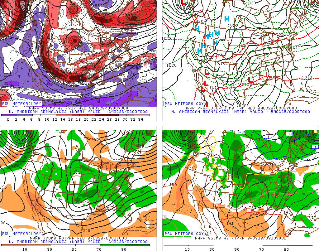
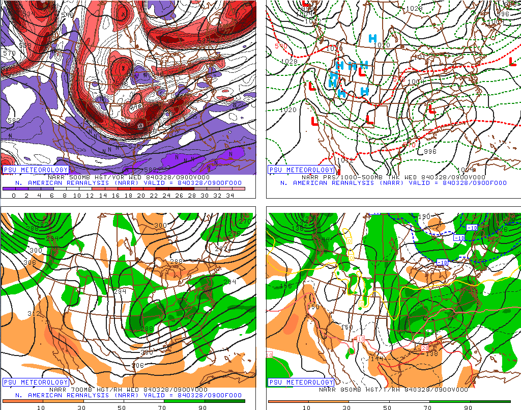
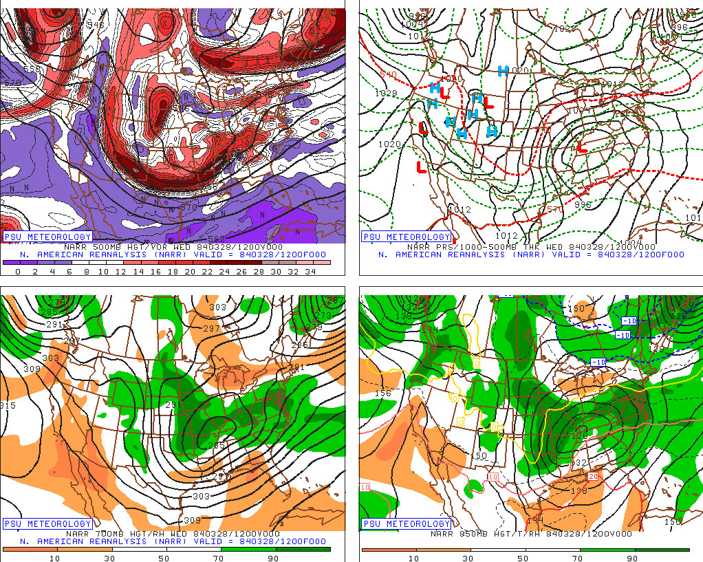
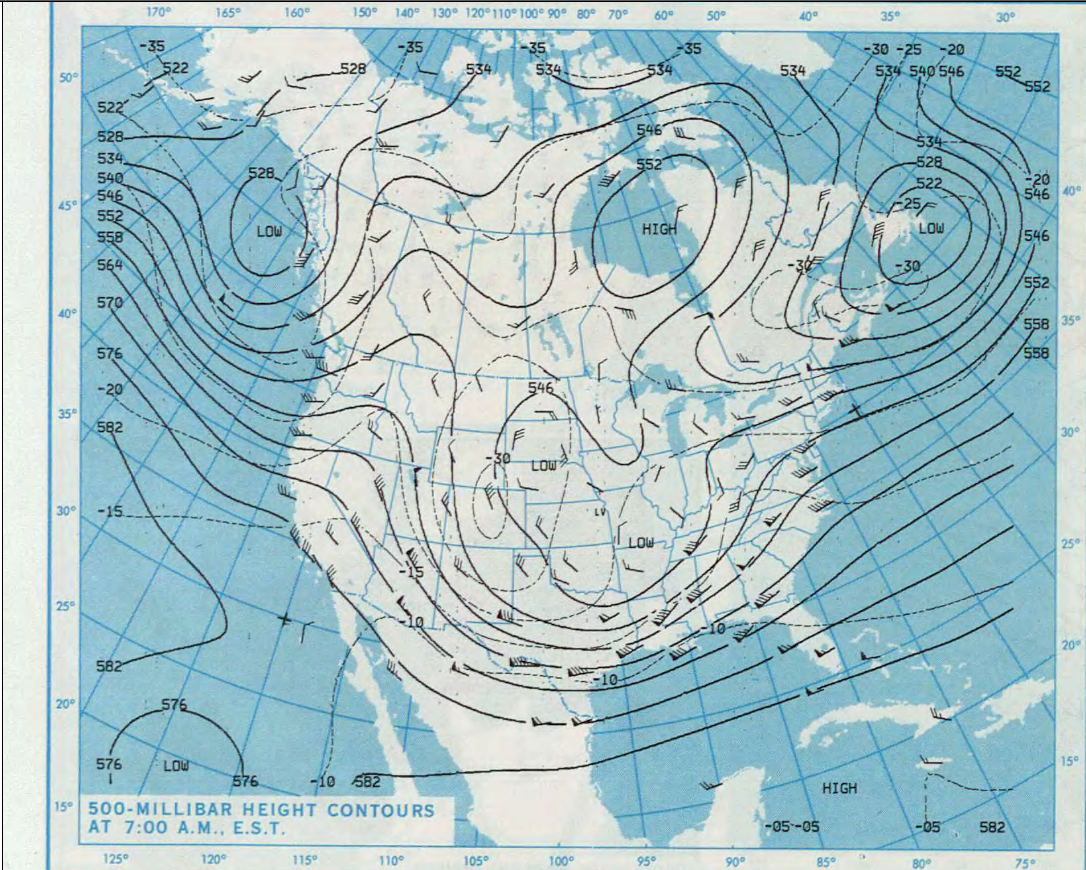
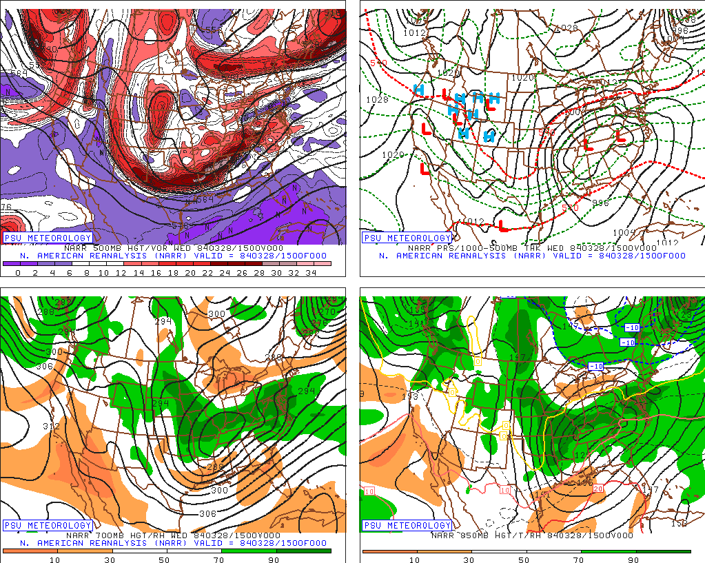
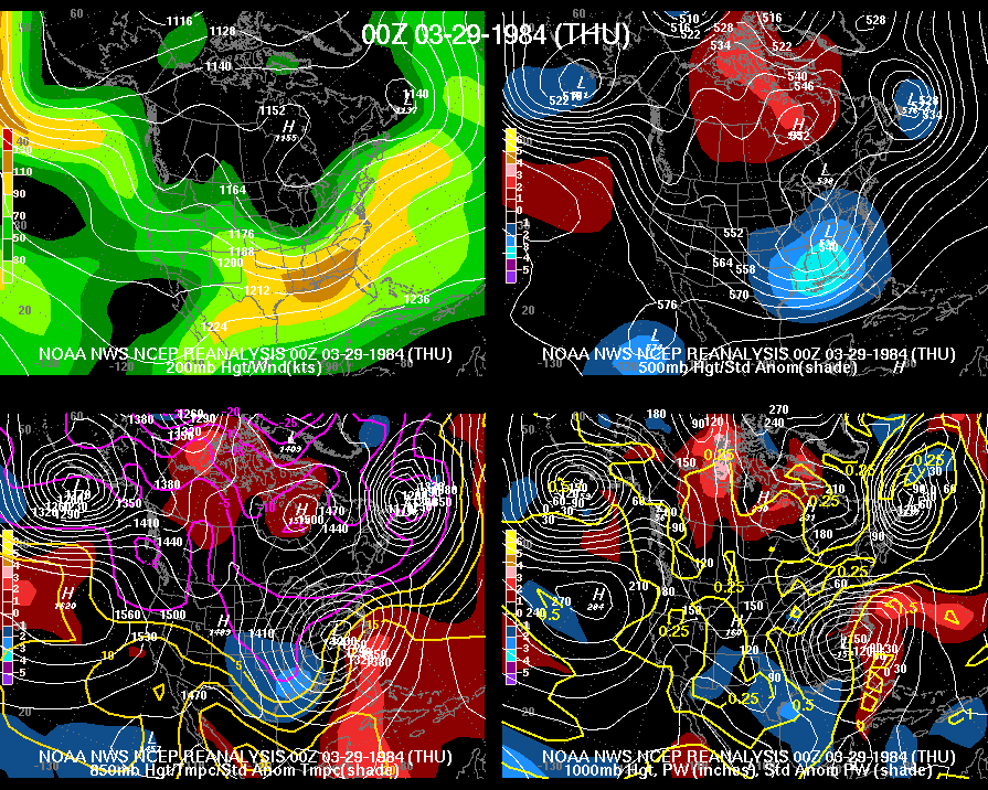
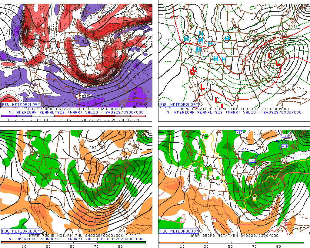
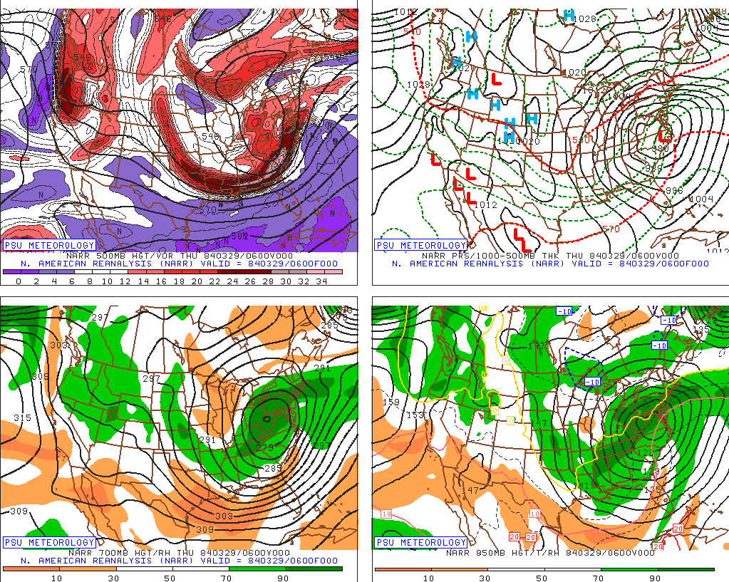
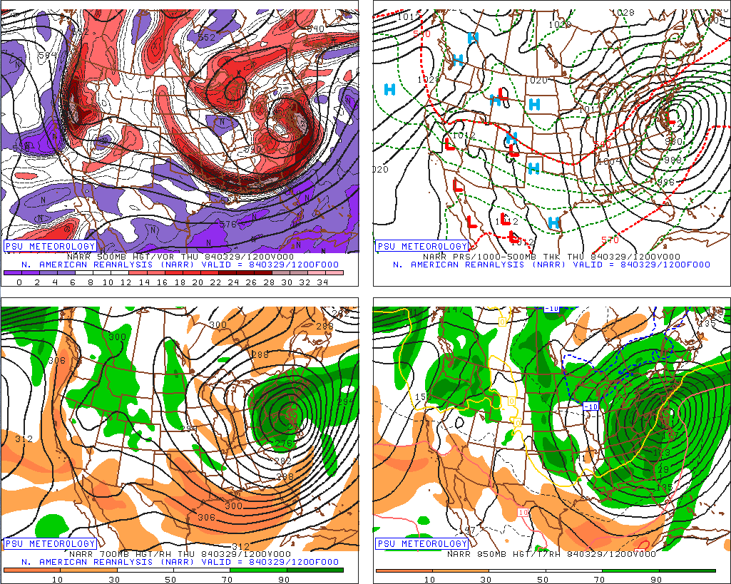
Weather Maps  The table below contains three-hourly maps from the North American Reanalysis project from Penn State, and twelve-hourly NCEP reanalysis maps. Both show the evolution of the upper level and surface patterns that produced the Carolinas Tornado Outbreak of March 28, 1984. Also shown are the NWS daily weather maps from the surface and the 500 mb level.
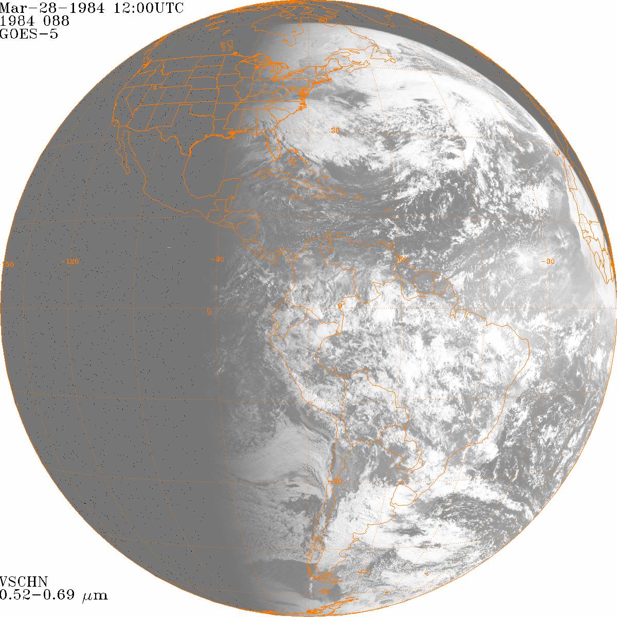
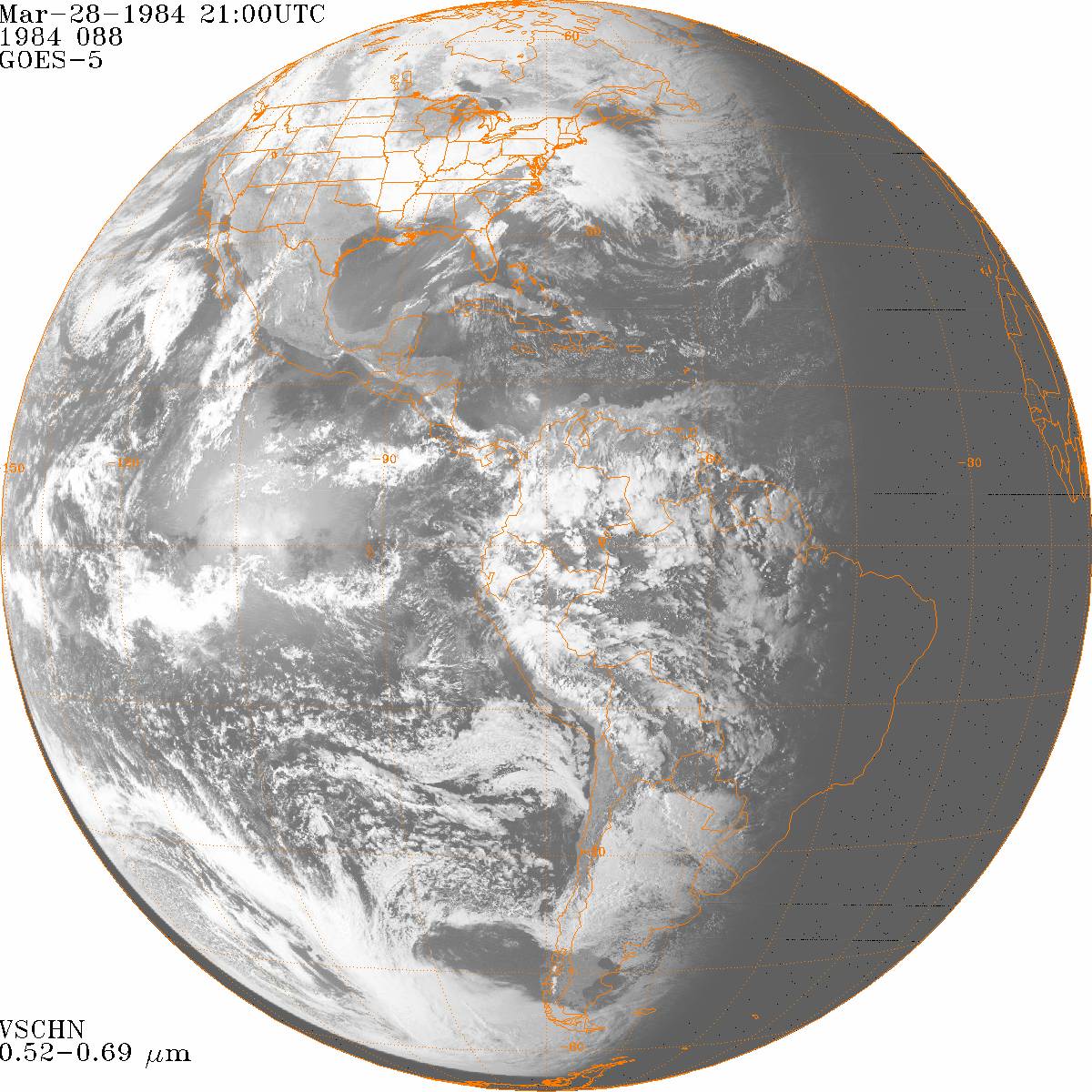
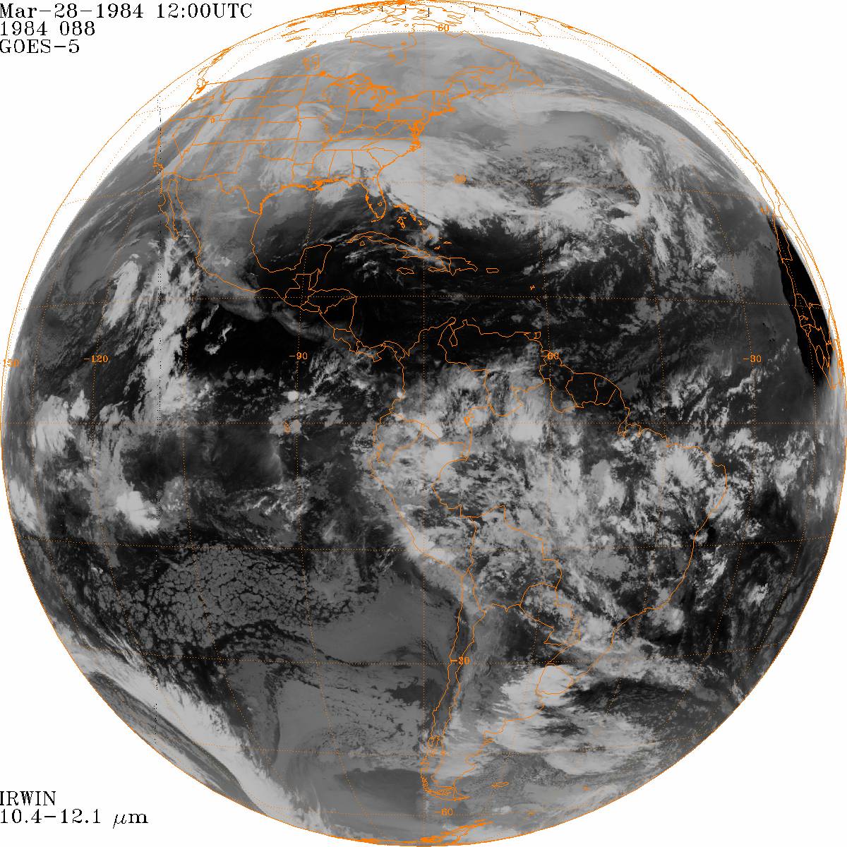
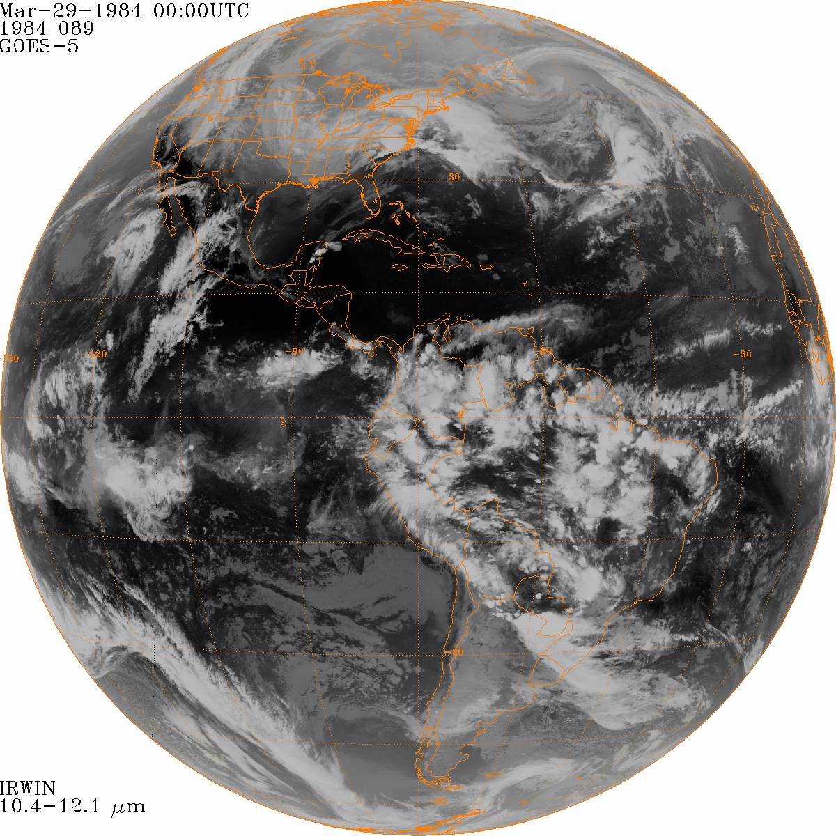
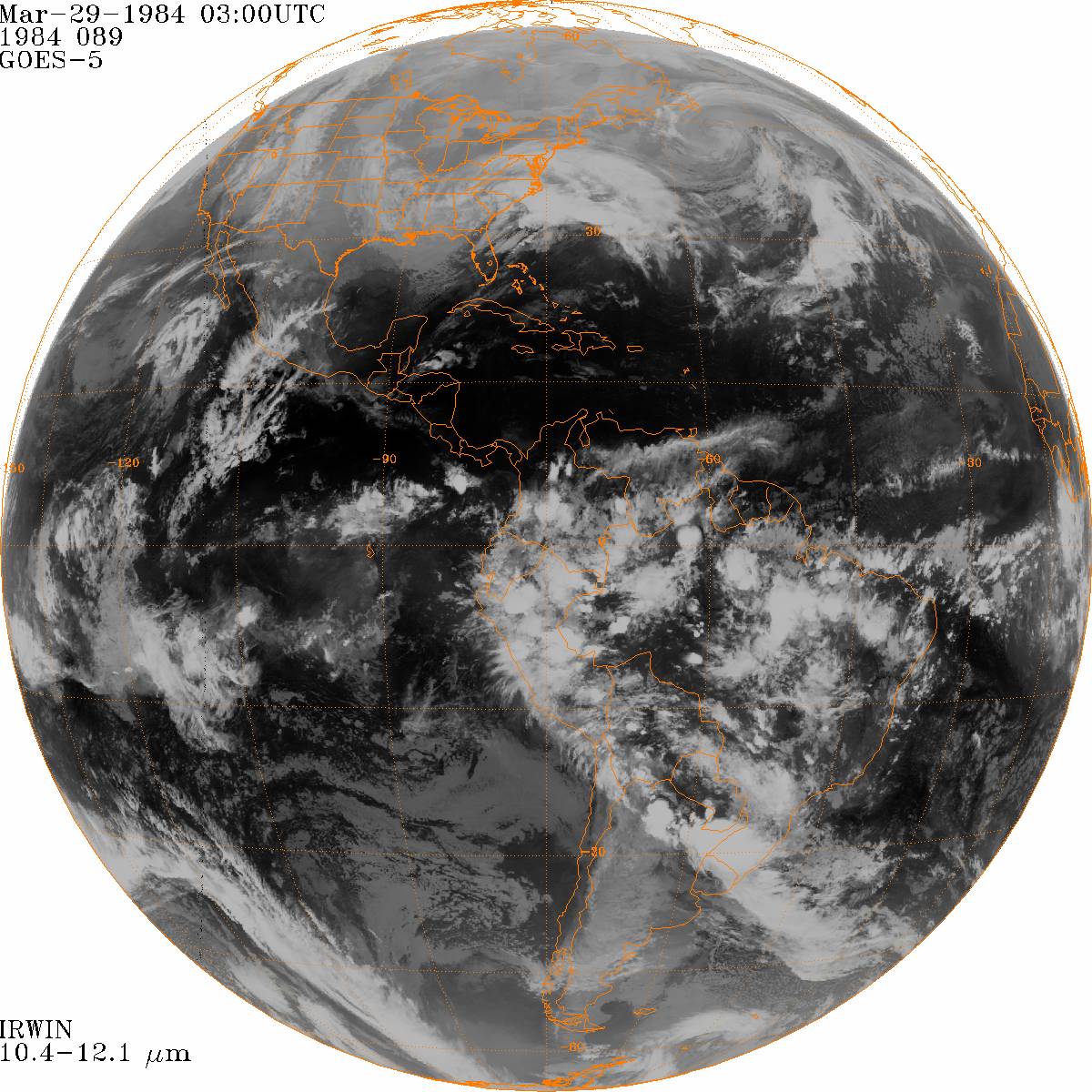
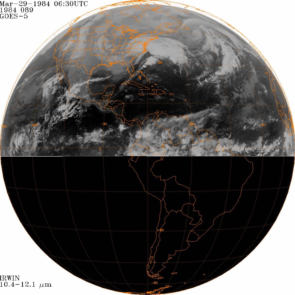
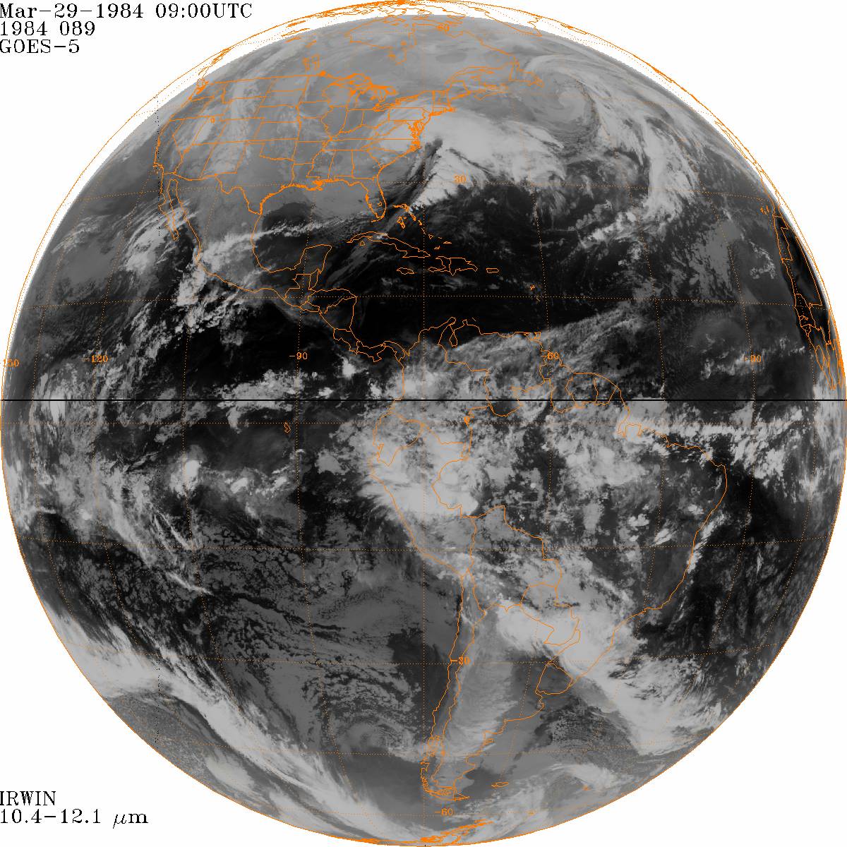
Satellite Imagery
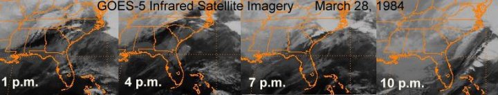 Both visible and infrared satellite imagery show thunderstorms developing across northern Georgia and the western and central Carolinas during the afternoon hours on March 28, 1984. These storms raced east-northeastward across the Sandhills and North Carolina Coastal Plain during the evening. Airport Weather Observations Weather observations from eight local airports are provided for the period from 1200 UTC on March 28 through 1200 UTC on March 29, 1984. Barometric pressures (shown in both millibars and inches of Mercury) were very low with this storm system, reaching as low as 28.88 inches in Florence, 28.90 inches at Kinston, and 28.95 inches in Wilmington. These are pressures normally only observed here in landfalling hurricanes and speak to the incredible power this storm had. Also notice the strong south winds that occurred just in advance of the cold front. In Wilmington at 10 p.m. on March 28th (290300 UTC) winds were from the south at 41 knots. (47 mph) Amazingly this wind was not associated with thunderstorms but was instead part of a broad swath of strong winds in the tight pressure gradient surrounding the low.
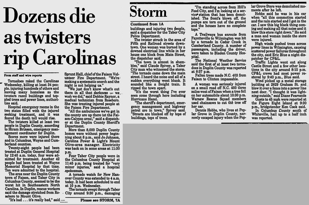
Local Newspaper Reports  The Wilmington Star-News archives are publicly available through the Google News Archive search at https://news.google.com/archivesearch Here are some local stories about the Carolinas Tornado Outbreak of March 28, 1984: The Wilmington Star-News archives are publicly available through the Google News Archive search at https://news.google.com/archivesearch Here are some local stories about the Carolinas Tornado Outbreak of March 28, 1984:
National Weather Service Products The National Climatic Data Center maintains an archive of all forecasts, discussions, warnings, and other products issued by all National Weather Service offices. Here are a few issued during the Carolinas Tornado Outbreak in 1984. Local Storm Reports Special Weather Statements Additional information on the Carolinas Outbreak of March 28, 1984 can be found at:
|


 Coastal Flood
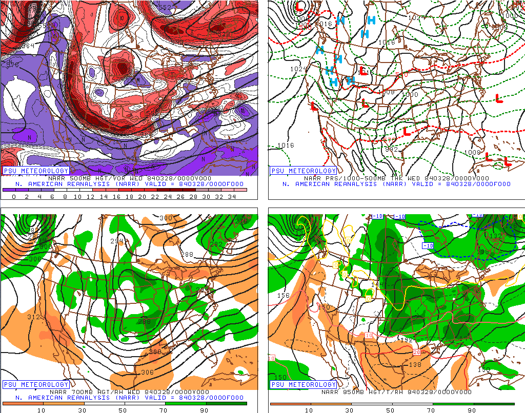