Overview
|
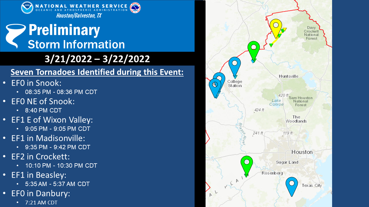
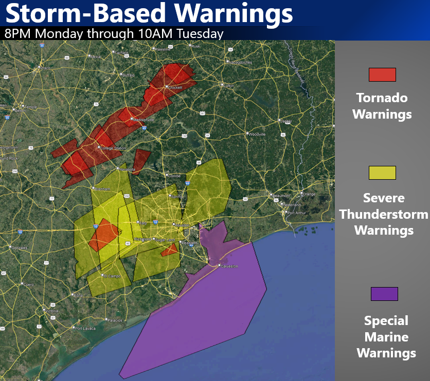
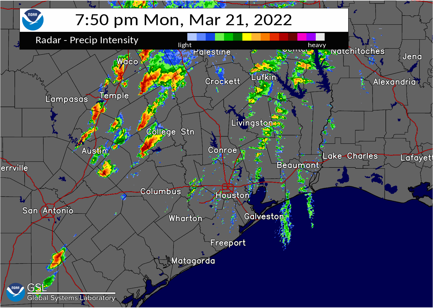
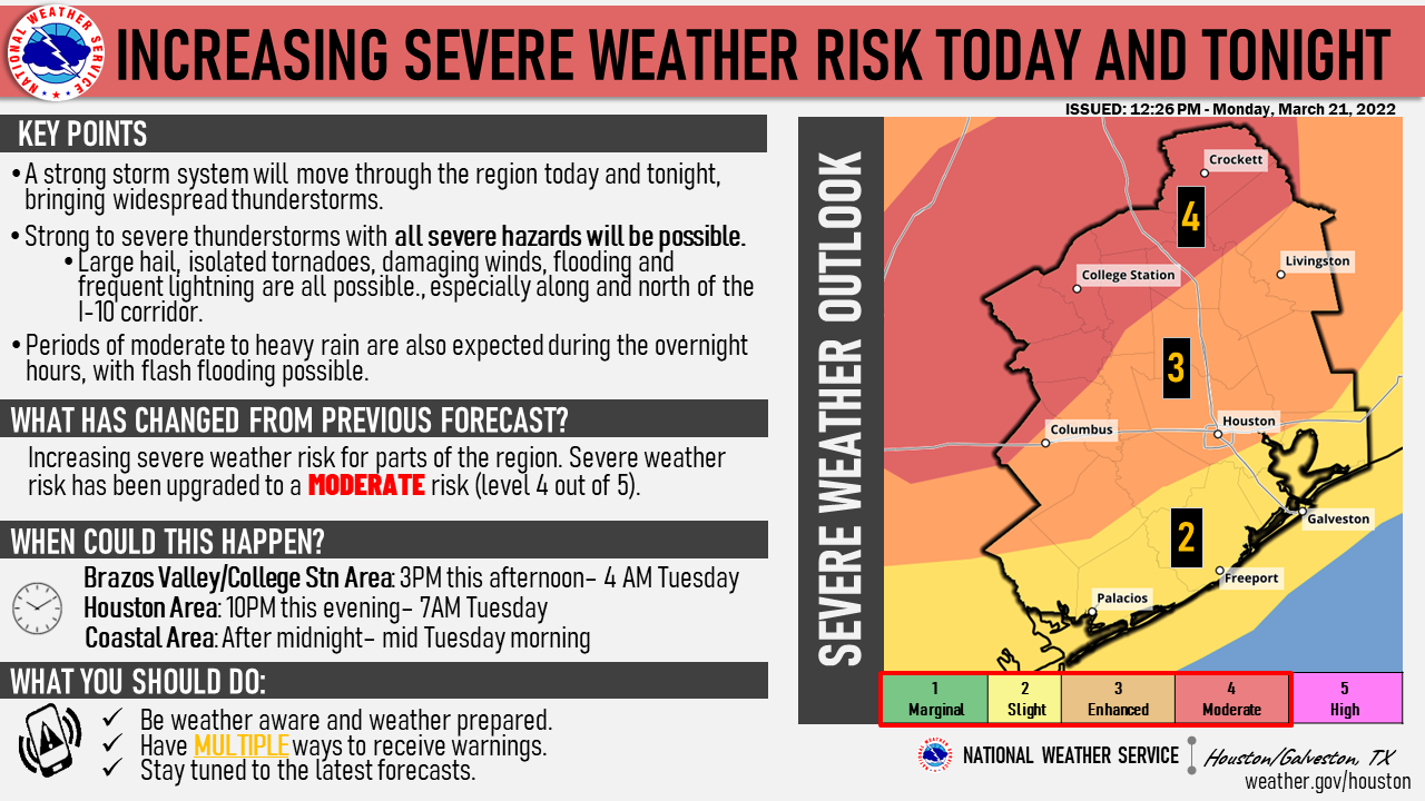
A warm front was moving up from the south on Monday, March 21st bringing in a moist and unstable airmass. A strong low level jet stretched across the Southern Plains, enhancing this moisture advection and bringing strong wind gusts to Southeast Texas. Long track supercells initiated along the dryline near Austin around 4 PM CDT and these discrete cells progressed further east and into our northwestern counties after sunset. Multiple, strong tornadoes were produced across south-central Texas from San Antonio up through Jarrel from these supercells. The tornadic activity continued as it moved into Southeast Texas. A long lived supercell that tracked from Burleson County northeastward through Houston County produced five tornadoes:
The storm that produced the five tornadoes above went on to produce additional tornadoes downstream in Shreveport's County Warning Area. A line of thunderstorms then passed through the region during the early morning hours of March 22nd that produced a couple of brief tornadoes along the bowing segment of the line (QLCS tornadoes):
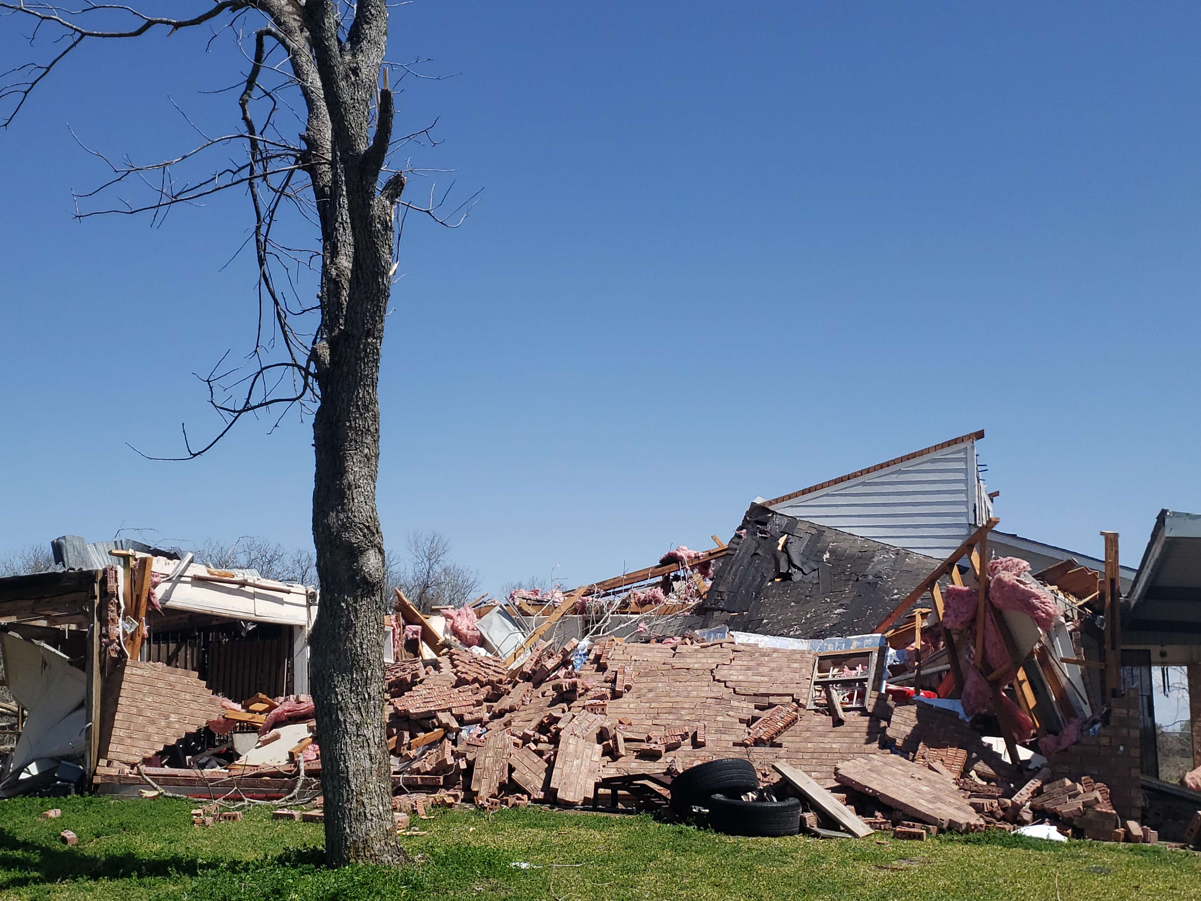
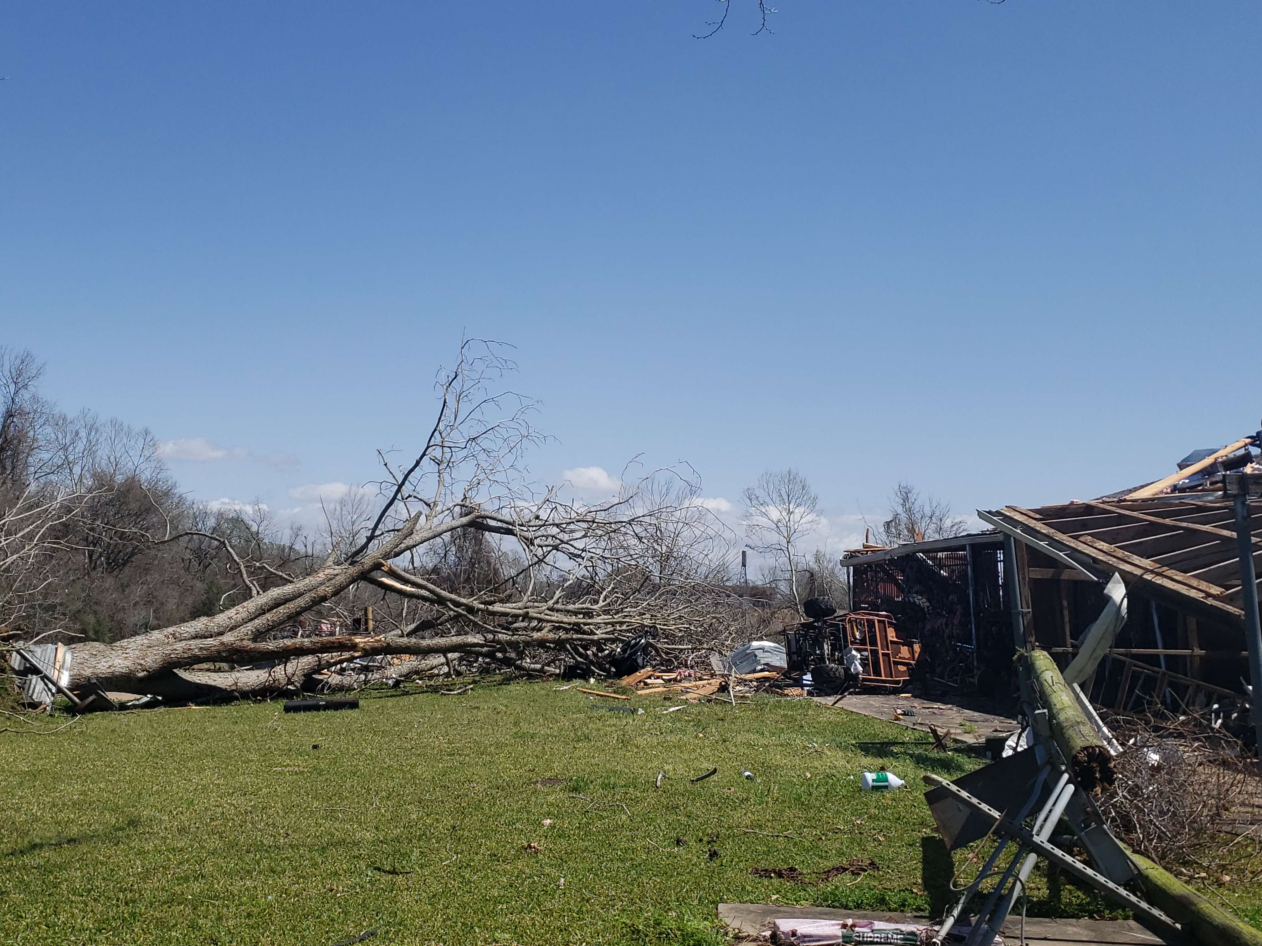
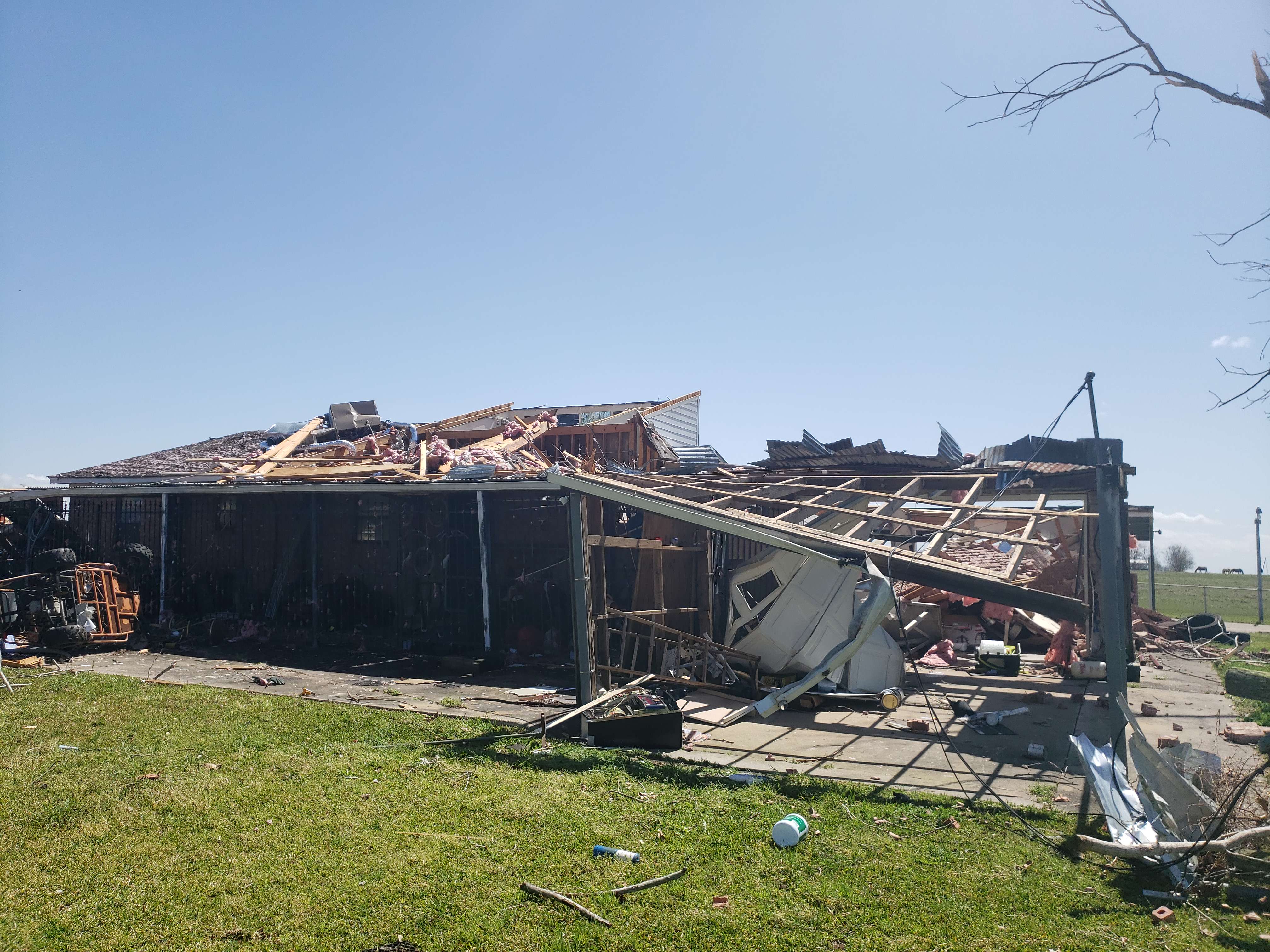
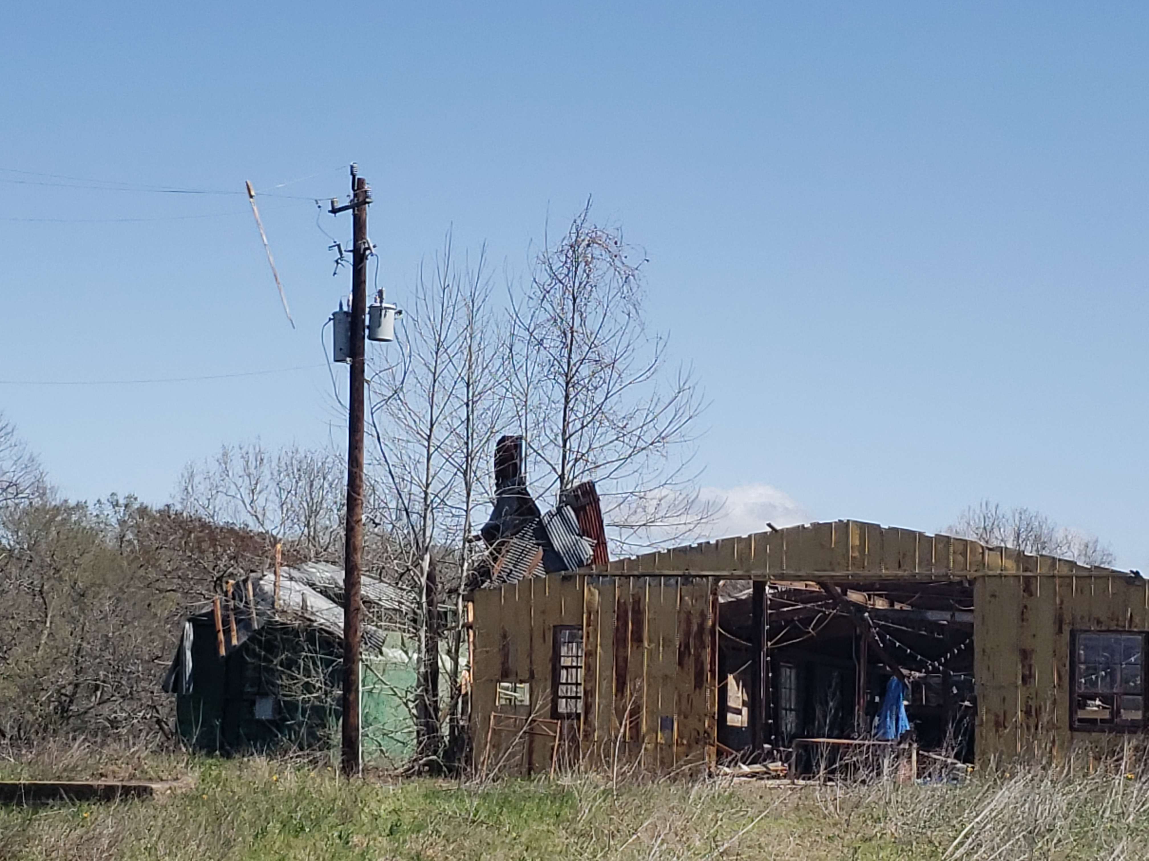
The tornadoes listed above resulted in significant damage to homes, businesses, vegetation, and other structures resulting in a total of 14 injuries (10 in the Houston County tornado, and 4 in the Beasley tornado).
Information is still currently preliminary and may be subject to change. |
|
Tornadoes:
|
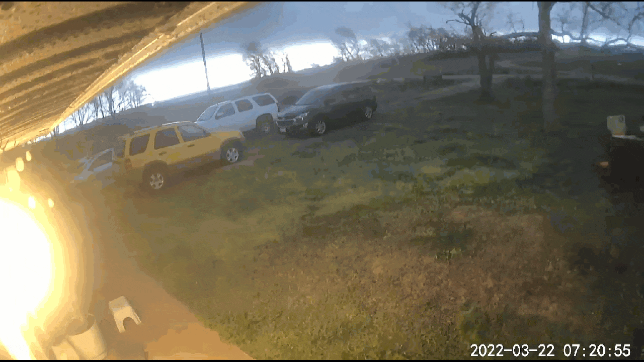
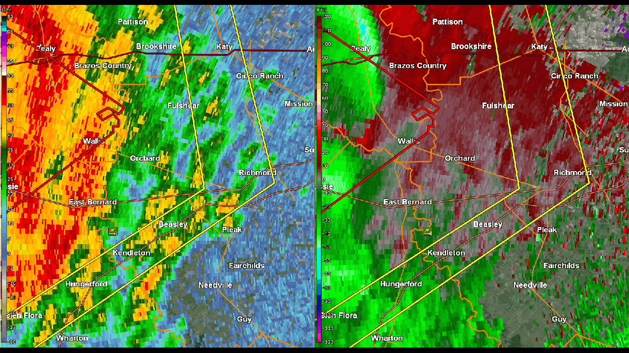
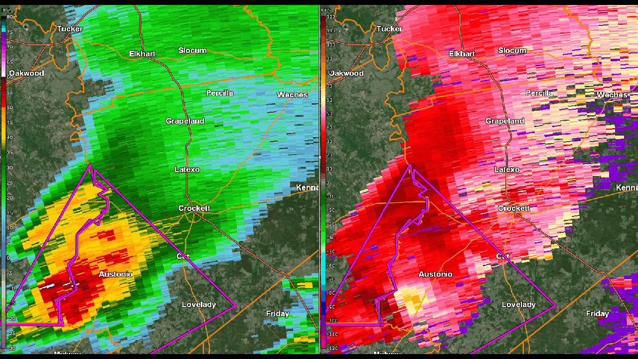
Beasley Tornado
Track Map 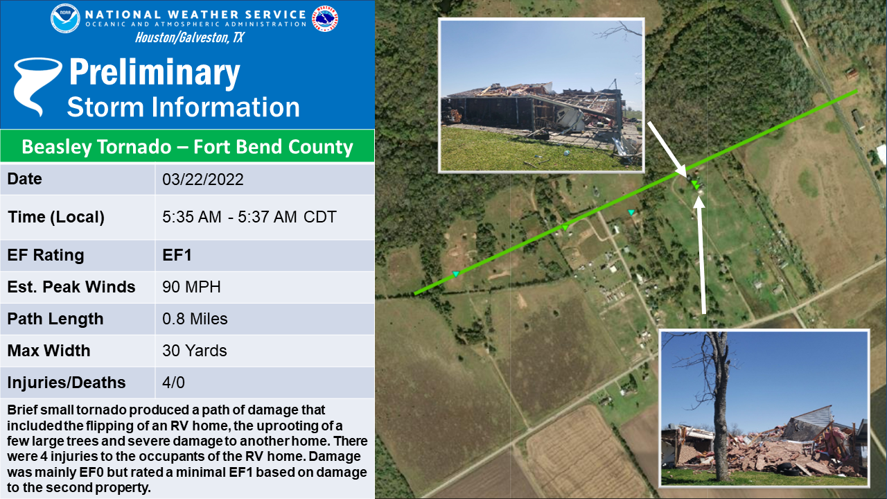 
|
||||||||||||||||
|
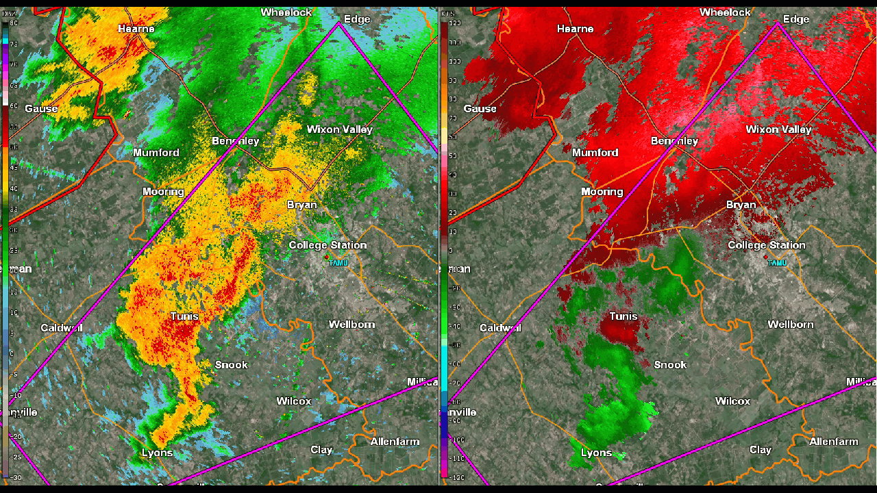
Snook Tornado
Track Map 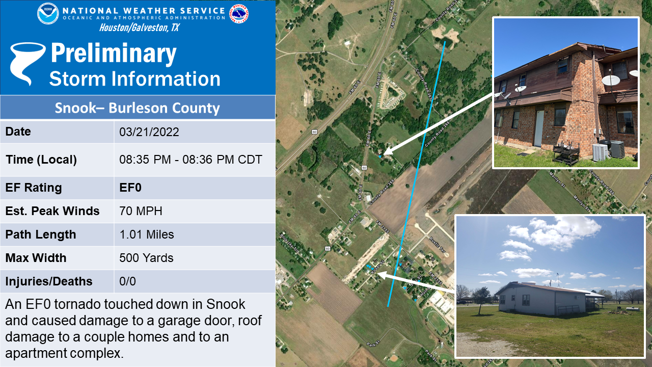
|
||||||||||||||||
|
4 NNE Snook Tornado
Track Map 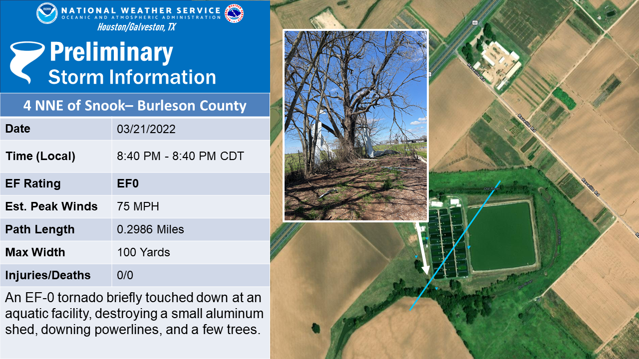
|
||||||||||||||||
|
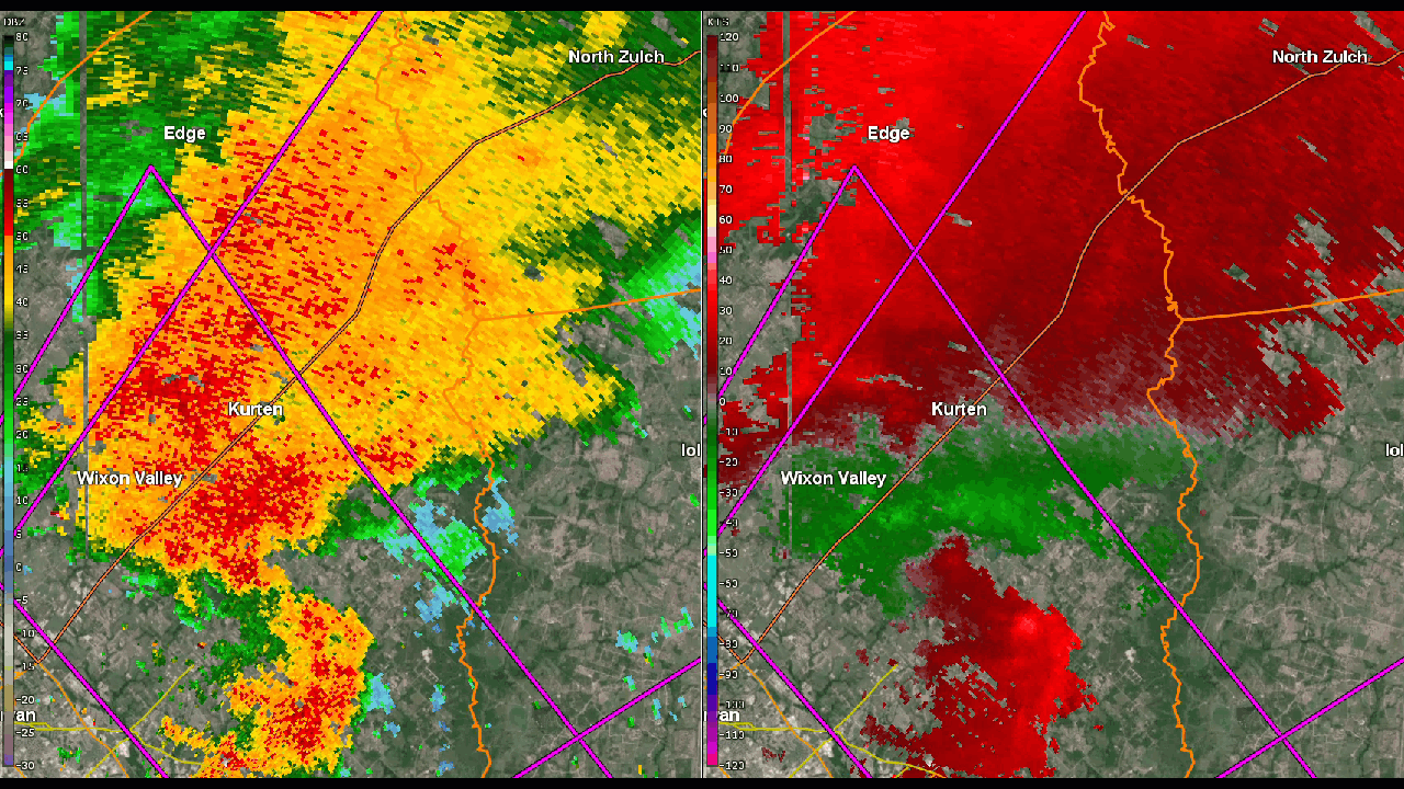
7 E of Wixon Valley Tornado
Track Map 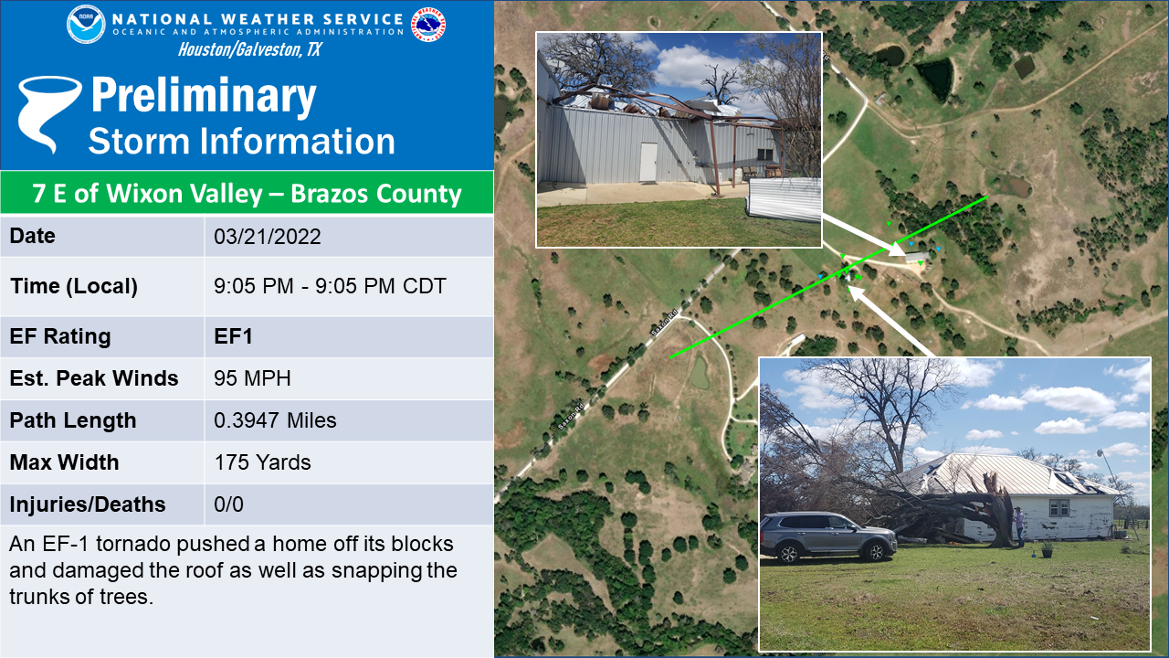
|
||||||||||||||||
|
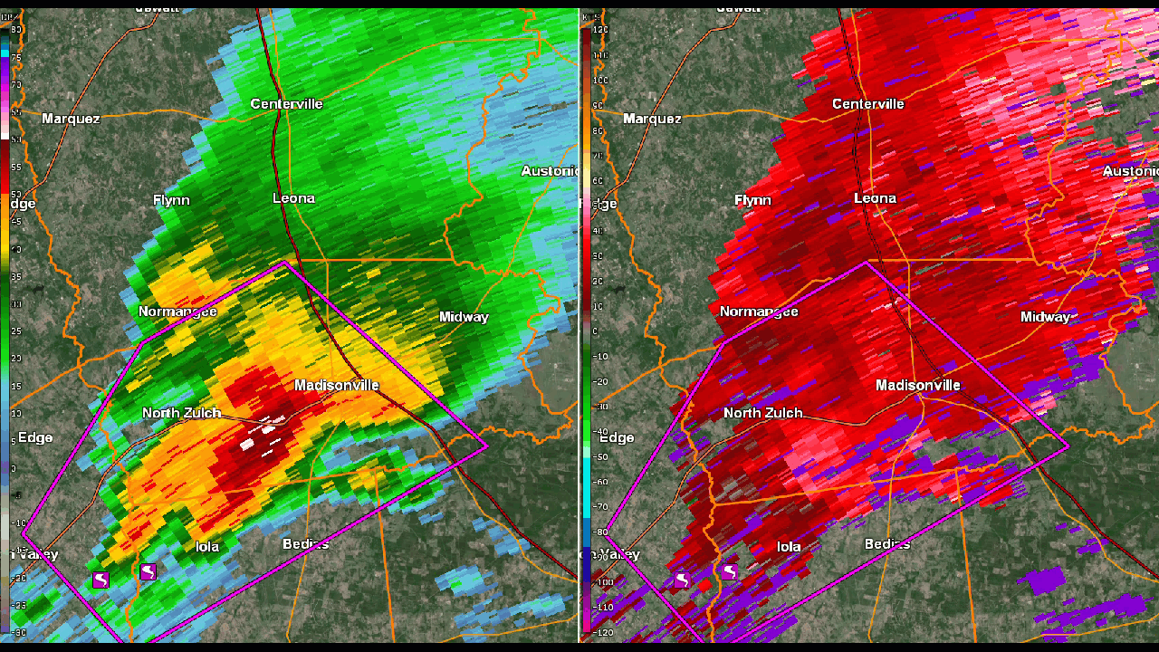
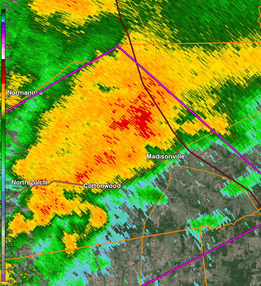
Madisonville Tornado
Track Map .png)
|
||||||||||||||||
|
Houston County Tornado
Track Map 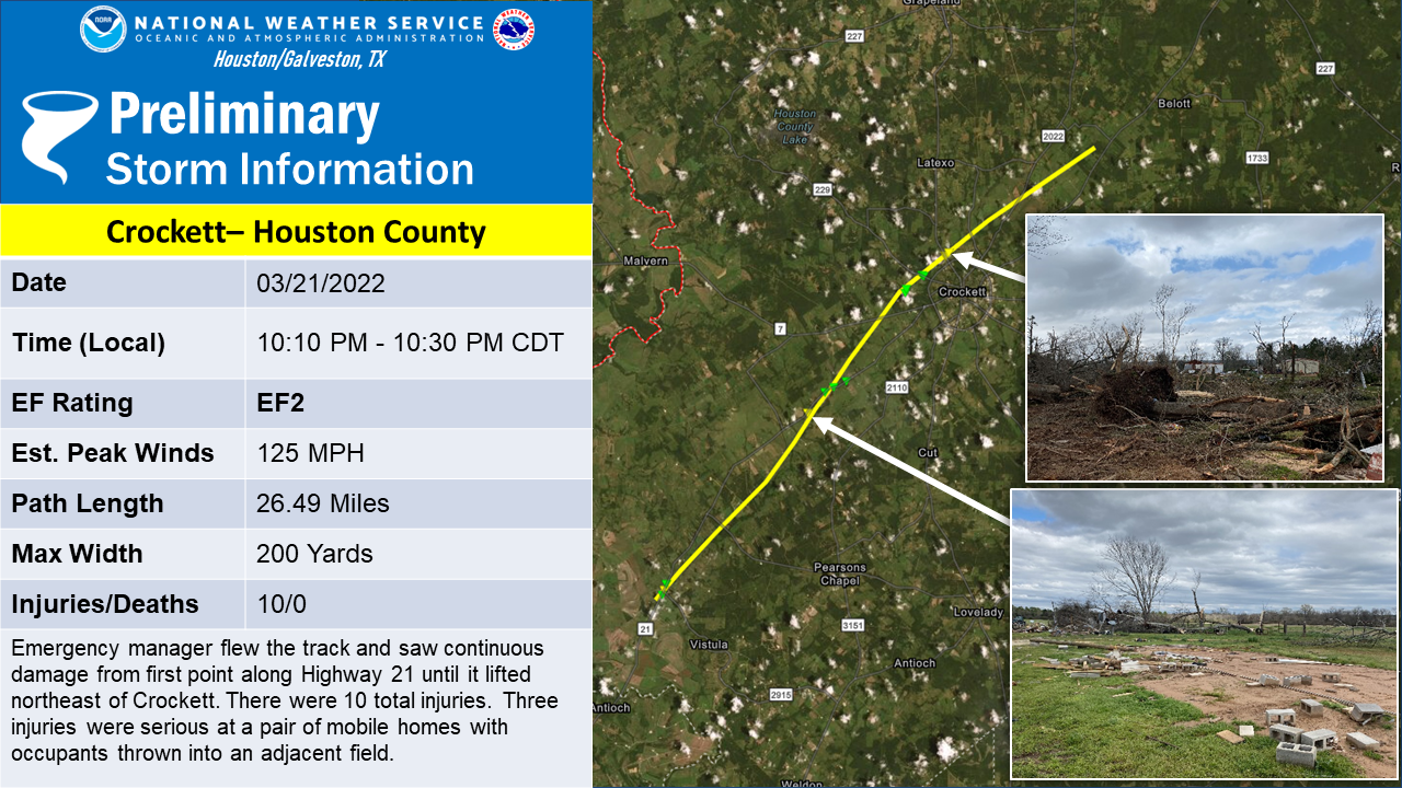
|
||||||||||||||||
|
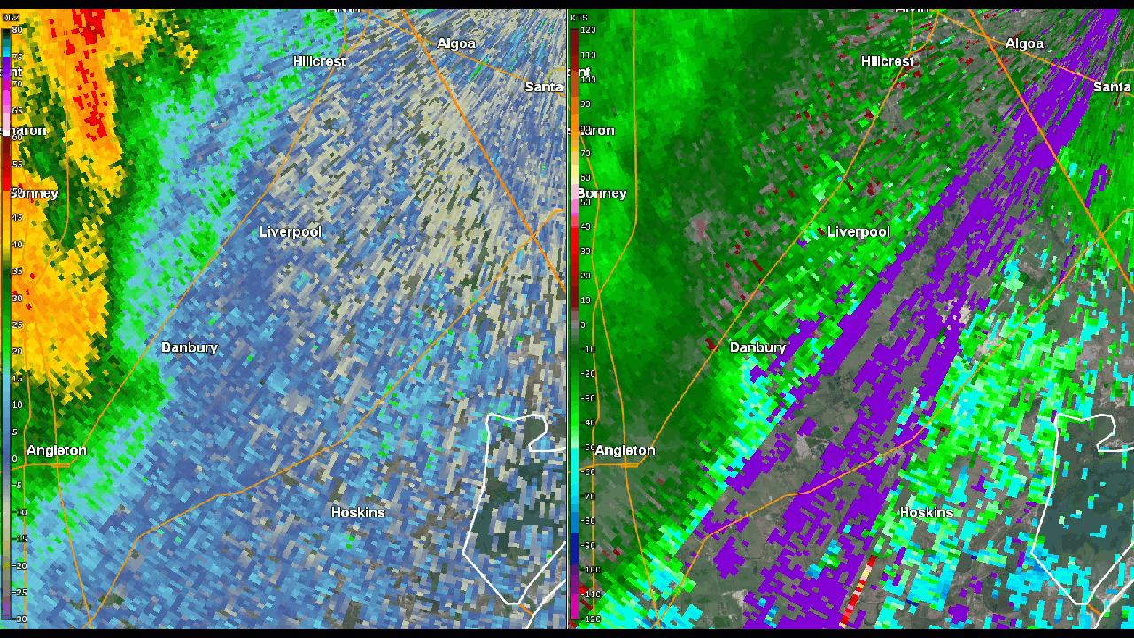
Danbury Tornado
Track Map 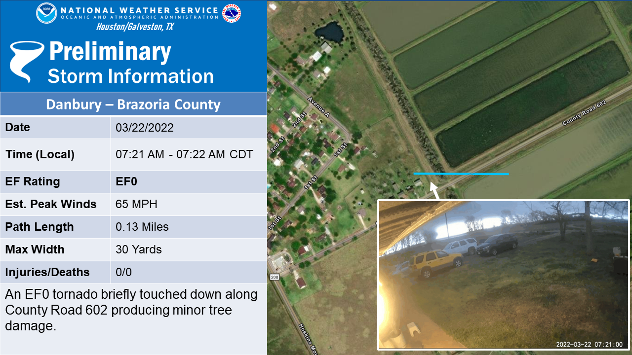
Downloadable KMZ File |
||||||||||||||||
The Enhanced Fujita (EF) Scale classifies tornadoes into the following categories:
| EF0 Weak 65-85 mph |
EF1 Moderate 86-110 mph |
EF2 Significant 111-135 mph |
EF3 Severe 136-165 mph |
EF4 Extreme 166-200 mph |
EF5 Catastrophic 200+ mph |
 |
|||||
Photos & Video
Beasley Tornado
 |
 |
 |
 |
| Damage To Building (NWS) |
Uprooted Trees (NWS) |
Damage To Building (NWS) |
Damage to Building (NWS) |
Snook Tornado
.jpg) |
.jpg) |
.jpg) |
.jpg) |
| Damage To Apartment Roof (NWS) |
Carport (staked) blown over (NWS) | Metal roof taken off of house (NWS) | Garage door blown in (NWS) |
4NNE Snook Tornado
.jpg) |
.jpg) |
.jpg) |
.jpg) |
| Damage To Trees (NWS) |
Metal structure damaged (NWS) | Damage To trees (NWS) |
Damage to Metal Building (NWS) |
Wixon Valley Tornado
.jpg) |
.jpg) |
.jpg) |
.jpg) |
| Uprooted Tree (NWS) |
Snapped Trees (NWS) |
Damage To Home (NWS) |
Damage to Building (NWS) |
Madisonville Tornado
.jpg) |
.jpg) |
.jpg) |
.jpg) |
| Damage To Home (NWS) |
Uprooted Trees (NWS) |
Damage To Building (brick facade removed) (NWS) |
Damage to Powerlines (NWS) |
Houston County Tornado
.jpg) |
.jpg) |
.jpg) |
.jpg) |
| Damage To Building (NWS) |
Snapped Trees (NWS) |
Damage To Building (NWS) |
Damage to Trees (NWS) |
.jpg) |
.jpg) |
.jpg) |
.jpg) |
| Damage To Trees (NWS) |
Damage to home (NWS) |
Damage To Trees (NWS) |
Damage to RV (NWS) |
Danbury Tornado
Radar
Header
 |
 |
 |
 |
| Beasley Tornado (KHGX) | Snook Tornadoes (TAMU) | Wixon Valley Tornado (TAMU) | Houston County Tornado (KHGX) |
 |
 |
 |
 |
| Danbury Tornado (KHGX) | Madisonville Tornado (KHGX) | Madisonville Tornado (TAMU) | MRMS Overview |
Special thanks to Texas A&M for use of their radar.
Citation:
Aggie Doppler Radar
Texas A&M University Department of Atmospheric Sciences
Storm Reports
..TIME... ...EVENT... ...CITY LOCATION... ...LAT.LON...
..DATE... ....MAG.... ..COUNTY LOCATION..ST.. ...SOURCE....
..REMARKS..
0833 PM Tornado 4 NNE Snook 30.54N 96.45W
03/21/2022 Burleson TX Emergency Mngr
Tornado reported near Snook at Highway 50 at
Highway 60 by Emergency Manager.
0859 PM Tornado 7 ESE Wixon Valley 30.74N 96.21W
03/21/2022 Brazos TX Broadcast Media
Damage to a home on Saxon Road in Brazos
County south of Kurten. Large tree snapped.
0909 PM Tornado 5 WSW Iola 30.75N 96.15W
03/21/2022 Grimes TX Trained Spotter
Corrects previous tornado report from 3 WSW
Snook. Storm chaser recorded footage of a
tornado near Iola.
0939 PM Tornado Madisonville 30.95N 95.91W
03/21/2022 Madison TX Trained Spotter
Storm chasers have recorded footage of a
tornado moving into Madisonville.
Substantial damage reported on Collar
Street@75.
1005 PM Tornado 10 NNE Midway 31.15N 95.66W
03/21/2022 Houston TX Broadcast Media
Roof of home taken off, shop and barn
damaged.
1013 PM Tornado 11 WNW Lovelady 31.17N 95.62W
03/21/2022 Houston TX Trained Spotter
Storm chasers intercept a large tornado and
significant debris about 1 mile to the
southwest of Austonio.
1023 PM Tornado 8 SW Crockett 31.25N 95.57W
03/21/2022 Houston TX Broadcast Media
*** 3 INJ ***
Two mobile homes completely destroyed near
CR3054 between Cooper and Crockett. Large
debris field. Three severe injuries.
1030 PM Tornado 2 NNW Crockett 31.34N 95.47W
03/21/2022 Houston TX Broadcast Media
Trees and powerlines down along Highway 287.
Gas station at Norman Lane and several
structures were damaged or destroyed.
Rain Reports
Location Amount Time/Date ...Texas... ...Austin County... Cat Spring 1.4 N 2.54 in 0741 AM 03/22 Bellville 4.3 NW 2.25 in 0800 AM 03/22 Bellville 6.5 NNE 2.16 in 0700 AM 03/22 Bellville 7.8 SSW 2.15 in 0800 AM 03/22 Bellville 0.4 NE 1.92 in 0600 AM 03/22 6.0 NE Bellville 1.86 in 0910 AM 03/22 Bellville 1 Sw 1.59 in 0100 PM 03/22 Bellville 1 SW 1.59 in 1255 PM 03/22 New Ulm 6.2 NNW 1.56 in 0726 AM 03/22 7.2 NE Eagle Lake 1.49 in 0700 PM 03/22 7.3 NE Eagle Lake 1.33 in 0100 PM 03/22 Eagle Lake 7 NE 1.33 in 1255 PM 03/22 8.8 NE Fayetteville 1.22 in 0100 PM 03/22 Industry 3 W 1.22 in 1255 PM 03/22 Cat Spring 1.03 in 0715 PM 03/22 Sealy 1.7 NNE 1.00 in 0700 AM 03/22 Sealy 1.9 NNE 0.99 in 0700 AM 03/22 San Felipe 1.0 WNW 0.97 in 0700 AM 03/22 San Felipe 0.87 in 0717 PM 03/22 ...Brazoria County... 1.6 E Freeport 1.68 in 0700 PM 03/22 Pearland 7.4 W 1.47 in 0800 AM 03/22 Damon 1 NNW 1.40 in 1215 PM 03/22 1.2 E Brookside Village 1.32 in 0712 PM 03/22 Katy 1.30 in 0716 PM 03/22 Pearland 3.4 WSW 1.24 in 0800 AM 03/22 4.2 W Brookside Village 1.16 in 0714 PM 03/22 Pearland 1.13 in 0717 PM 03/22 Manvel 1.08 in 0716 PM 03/22 Iowa Colony 1.05 in 0716 PM 03/22 1.3 E Pearland (HCFCD) 0.95 in 0710 PM 03/22 Clute 0.88 in 0718 PM 03/22 West Columbia 0.86 in 0715 PM 03/22 Alvin 0.84 in 0718 PM 03/22 1 E Freeport 0.81 in 0725 PM 03/22 Pearland 0.74 in 0653 PM 03/22 San Bernard Nwr 0.71 in 0629 PM 03/22 1.2 E West Columbia 0.71 in 0800 AM 03/22 West Columbia 0.68 in 0715 PM 03/22 Lake Jackson 0.62 in 0711 PM 03/22 Richwood 0.60 in 0725 PM 03/22 Lake Jackson 0.57 in 0725 PM 03/22 Brazoria County Airport 0.56 in 0653 PM 03/22 1 E Lake Jackson 0.51 in 0725 PM 03/22 ...Brazos County... Bryan 3.5 NNW 3.44 in 0800 AM 03/22 Bryan 7.1 N 2.86 in 0700 AM 03/22 Coulter Fld Ap 2.30 in 0715 PM 03/22 Bryan 3.3 ESE 1.62 in 0800 AM 03/22 3 NNE College Station 1.60 in 0720 PM 03/22 College Station 1.7 NNW 1.58 in 0900 AM 03/22 Easterwood Field Airport 1.44 in 0653 PM 03/22 College Station 4.5 SW 1.43 in 0700 AM 03/22 2 NNE College Station 1.43 in 0800 AM 03/22 2 SSE College Station 1.14 in 0720 PM 03/22 College Station 2.0 SSE 1.14 in 0600 AM 03/22 College Station 2.4 E 1.10 in 0700 AM 03/22 College Station 6.4 ENE 1.10 in 0700 AM 03/22 Bryan 10.1 E 1.08 in 0700 AM 03/22 College Station 3.9 NE 1.07 in 0700 AM 03/22 3 NNE UP429 1.01 in 0724 AM 03/22 3 E UP429 0.95 in 0725 PM 03/22 College Station 5.7 S 0.94 in 0700 AM 03/22 1 ENE College Station 0.89 in 0724 PM 03/22 3 E Wellborn 0.72 in 0720 PM 03/22 ...Burleson County... Somerville 1.52 in 0710 PM 03/22 Snook 1.46 in 0715 PM 03/22 Caldwell 1.8 NE 1.45 in 0700 AM 03/22 5.2 N Somerville 0.39 in 0700 PM 03/22 Caldwell 0.18 in 0715 PM 03/22 ...Chambers County... Baytown 1.27 in 0717 PM 03/22 Anahuac 5.7 N 1.02 in 0650 PM 03/22 Mont Belvieu 0.95 in 0715 PM 03/22 7.4 N Anahuac 0.86 in 0615 PM 03/22 Anahuac 0.57 in 0612 PM 03/22 Anahuac 0.08 in 0724 PM 03/22 Mont Belvieu 0.01 in 0725 PM 03/22 ...Colorado County... Columbus 3.2 WSW 1.98 in 0700 AM 03/22 11.2 SW Eagle Lake 1.97 in 1257 PM 03/22 Colorado River at Columbus 1.83 in 1255 PM 03/22 0.9 E Columbus 1.82 in 0715 PM 03/22 Weimar 9.3 SE 1.80 in 0700 AM 03/22 Columbus 9.5 NE 1.75 in 0700 AM 03/22 Fayetteville 3.5 E 1.57 in 0300 PM 03/22 Columbus 1.56 in 0715 PM 03/22 7.9 SE Fayetteville 1.50 in 0100 PM 03/22 Cummins Creek near Frelsburg 1.50 in 1255 PM 03/22 10.5 NE Speaks 1.42 in 0700 PM 03/22 Weimar 1.42 in 0715 PM 03/22 Eagle Lake 1.36 in 0715 PM 03/22 Attwater Nwr 1.34 in 0635 PM 03/22 Weimar 5.3 SW 1.30 in 0800 AM 03/22 Weimar 5.0 E 1.30 in 0845 AM 03/22 14.4 S Columbus 1.18 in 0700 PM 03/22 6.8 S Weimar 1.11 in 0100 PM 03/22 Weimar 7 S 1.11 in 1255 PM 03/22 ...Fort Bend County... 0.9 S Katy (HCFCD) 2.28 in 0702 PM 03/22 Missouri City 5.1 SSE 1.91 in 0600 AM 03/22 2.3 SW Town West 1.84 in 0400 PM 03/22 Missouri City 1.79 in 0716 PM 03/22 Fulshear 1.73 in 0715 PM 03/22 First Colony 1.68 in 0720 PM 03/22 Fulshear 0.9 NNE 1.67 in 0730 AM 03/22 Sugar Land 1.66 in 0715 PM 03/22 Sugar Land .5 SE 1.58 in 0700 AM 03/22 2.2 SW Sugar Land 1.56 in 0715 PM 03/22 Sugar Land 1.0 W 1.56 in 0700 AM 03/22 0.9 NE First Colony 1.52 in 0720 PM 03/22 Houston Sugar La 1.45 in 0653 PM 03/22 1.9 W First Colony 1.44 in 0715 PM 03/22 0.9 SW Sugar Land 1.44 in 0705 PM 03/22 Richmond 2.7 NNE 1.43 in 0700 AM 03/22 Katy 1.42 in 0716 PM 03/22 Richmond 4.6 SE 1.41 in 0800 AM 03/22 4 WSW First Colony 1.38 in 0720 PM 03/22 Sugar Land 1.31 in 0716 PM 03/22 Richmond 4.6 N 1.31 in 0800 AM 03/22 Katy 1.26 in 0715 PM 03/22 1 ESE Richmond 1.25 in 0700 AM 03/22 Rosenberg 1.24 in 0717 PM 03/22 Richmond 1.24 in 0700 PM 03/22 Richmond 1.22 in 0720 PM 03/22 Richmond 2.3 SE 1.20 in 0800 AM 03/22 Richmond 1.15 in 0715 PM 03/22 2 SE Richmond 1.12 in 0720 PM 03/22 Katy 1.12 in 0715 PM 03/22 Houston Southwst 1.09 in 0715 PM 03/22 Richmond 1.08 in 0715 PM 03/22 Katy 1.07 in 0715 PM 03/22 Katy 1.07 in 0717 PM 03/22 3 SW Thompsons 1.01 in 0720 PM 03/22 ...Galveston County... League City 1.25 in 1059 AM 03/22 Santa Fe 1.05 in 0716 PM 03/22 Santa Fe 0.98 in 0715 PM 03/22 3.1 SE San Leon 0.97 in 0630 PM 03/22 2.1 N Friendswood (HCFCD) 0.96 in 0708 PM 03/22 1.8 N Friendswood 0.96 in 0705 PM 03/22 2.5 NW Friendswood (HCFCD) 0.96 in 0702 PM 03/22 1.5 SW Friendswood 0.88 in 0705 PM 03/22 1.5 W Friendswood (HCFCD) 0.88 in 0704 PM 03/22 2 WSW Kemah 0.82 in 0720 PM 03/22 Texas City 0.82 in 0715 PM 03/22 Santa Fe 0.81 in 0720 PM 03/22 Crystal Beach 2.2 ENE 0.80 in 0900 AM 03/22 League City 0.78 in 0715 PM 03/22 League City 0.78 in 0715 PM 03/22 1.5 W Friendswood 0.76 in 0710 PM 03/22 2.0 SW Friendswood (HCFCD) 0.76 in 0706 PM 03/22 1.2 E Friendswood (HCFCD) 0.68 in 0705 PM 03/22 1 SW Kemah 0.67 in 0725 PM 03/22 2.1 NW Bayou Vista 0.67 in 0600 PM 03/22 1 SSE Texas City 0.67 in 0725 PM 03/22 League City 2.7 NE 0.66 in 0800 AM 03/22 League City 0.64 in 0717 PM 03/22 Galveston 8.3 NE 0.63 in 0920 AM 03/22 1 NE League City 0.60 in 0725 PM 03/22 ...Grimes County... Navasota 6.7 E 2.56 in 0700 AM 03/22 7 SW Richards 2.30 in 0700 AM 03/22 Navasota 2.16 in 0715 PM 03/22 9 SSE Navasota 1.90 in 0800 AM 03/22 Iola 10.4 SSW 1.19 in 0800 AM 03/22 15.3 N Navasota 1.11 in 0700 PM 03/22 Navasota 0.59 in 0725 PM 03/22 ...Harris County... 2.2 S Kingwood (HCFCD) 2.32 in 0702 PM 03/22 4.6 SE Humble (HCFCD) 2.28 in 0343 PM 03/22 Kingwood 2.4 W 2.26 in 0900 AM 03/22 2.3 SE Houston 2.24 in 0400 PM 03/22 Kingwood 0.9 WNW 2.22 in 0700 AM 03/22 6.2 NE Katy (HCFCD) 2.20 in 0710 PM 03/22 2.0 S Kingwood 2.16 in 0705 PM 03/22 Houston 2.14 in 0716 PM 03/22 Cypress 3.2 ENE 2.14 in 0700 AM 03/22 2.1 S Humble (HCFCD) 2.12 in 0347 PM 03/22 Jersey Village 8.5 NW 2.05 in 0715 AM 03/22 Humble 2.04 in 0720 PM 03/22 Bunker Hill Village 3.6 NNW 2.03 in 0700 AM 03/22 Houston 2.00 in 0719 PM 03/22 2.2 N Humble 2.00 in 0705 PM 03/22 8.1 NW Jersey Village 1.96 in 0327 PM 03/22 8.8 NE Jersey Village 1.96 in 0321 PM 03/22 Houston 1.93 in 0715 PM 03/22 Bunker Hill Village 4.4 WSW 1.93 in 0800 AM 03/22 6.3 NW Jacinto City (HCFCD) 1.92 in 0351 PM 03/22 0.7 E Jersey Village (HCFCD) 1.92 in 0348 PM 03/22 Spring Valley 2.7 NW 1.90 in 0800 AM 03/22 4.5 W Bunker Hill Village 1.89 in 0319 PM 03/22 Cypress 1.89 in 0710 PM 03/22 2.4 S Tomball (HCFCD) 1.88 in 0335 PM 03/22 Spring 1.87 in 0718 PM 03/22 5.1 NE Jersey Village 1.84 in 0350 PM 03/22 6.3 NW Jersey Village 1.84 in 0325 PM 03/22 5.3 E Kingwood (HCFCD) 1.84 in 0359 PM 03/22 5.9 NE Jersey Village 1.83 in 0349 PM 03/22 Cypress 1.83 in 0720 PM 03/22 3.9 SE Spring 1.80 in 0720 PM 03/22 3.9 SE Spring (HCFCD) 1.80 in 0317 PM 03/22 4.2 E Aldine (HCFCD) 1.80 in 0344 PM 03/22 7.2 NW Jersey Village 1.80 in 0331 PM 03/22 4.7 SE Houston 1.80 in 0400 PM 03/22 3.2 SW Spring (HCFCD) 1.80 in 0319 PM 03/22 3 NE Town West 1.78 in 0725 PM 03/22 Jersey Village 6.4 W 1.78 in 0802 AM 03/22 4.7 NE Katy (HCFCD) 1.77 in 0711 PM 03/22 2.5 SW Spring 1.76 in 0720 PM 03/22 3.2 SW Spring 1.76 in 0720 PM 03/22 6 WSW Spring 1.75 in 0725 PM 03/22 Katy 1.73 in 0715 PM 03/22 2.5 SW Spring (HCFCD) 1.72 in 0318 PM 03/22 Cypress 1.72 in 0718 PM 03/22 10.5 N Katy (HCFCD) 1.72 in 0327 PM 03/22 Hedwig Village 1.1 NNW 1.71 in 0715 AM 03/22 7.3 S Humble (HCFCD) 1.69 in 0341 PM 03/22 3.5 NW Houston (HCFCD) 1.68 in 0344 PM 03/22 5.5 NW Cloverleaf (HCFCD) 1.68 in 0352 PM 03/22 6.6 N Hilshire Village 1.68 in 0355 PM 03/22 Katy 8.9 NE 1.67 in 0700 AM 03/22 Cypress 1.66 in 0715 PM 03/22 3 WSW Bunker Hill Village 1.65 in 0118 PM 03/22 5.0 N Jacinto City (HCFCD) 1.64 in 0343 PM 03/22 6.3 NW Mission Bend (HCFCD) 1.64 in 0701 PM 03/22 2.5 W Bunker Hill Village 1.64 in 0319 PM 03/22 Houston 1.63 in 0716 PM 03/22 Tomball 1.63 in 0718 PM 03/22 Houston 1.61 in 0718 PM 03/22 4.3 SE Aldine (HCFCD) 1.60 in 0351 PM 03/22 6.1 W Spring (HCFCD) 1.60 in 0320 PM 03/22 4.9 W Jersey Village 1.60 in 0705 PM 03/22 3.4 E Katy 1.60 in 0710 PM 03/22 7.8 N Mission Bend (HCFCD) 1.60 in 0707 PM 03/22 Buffalo Bayou Nr Addicks 1.56 in 0720 PM 03/22 1.5 E Houston (HCFCD) 1.56 in 0713 PM 03/22 7.4 SW Tomball (HCFCD) 1.56 in 0332 PM 03/22 1 SSW Pasadena 1.56 in 0724 PM 03/22 1.7 NW Highlands (HCFCD) 1.56 in 0400 PM 03/22 Tomball 1.56 in 0724 PM 03/22 2.8 E Hilshire Village 1.56 in 0715 PM 03/22 2.9 E Hilshire Village 1.56 in 0711 PM 03/22 5.5 N Hilshire Village 1.56 in 0354 PM 03/22 5.6 N Hilshire Village 1.56 in 0346 PM 03/22 Spring 1.55 in 0718 PM 03/22 1.2 E Aldine (HCFCD) 1.55 in 0355 PM 03/22 Mission Bend 5.6 NNW 1.54 in 0800 AM 03/22 3 NW Hedwig Village 1.53 in 0725 PM 03/22 3.3 S Oak Ridge North 1.53 in 0714 PM 03/22 3.5 NE Meadows (HCFCD) 1.52 in 0334 PM 03/22 1.9 NE Mission Bend (HCFCD) 1.52 in 0338 PM 03/22 2.3 NE Aldine (HCFCD) 1.52 in 0345 PM 03/22 3.8 NW Aldine (HCFCD) 1.52 in 0347 PM 03/22 6.7 N Jersey Village (HCFCD) 1.52 in 0322 PM 03/22 Houston Intnl 1.51 in 0653 PM 03/22 Spring 1.50 in 0719 PM 03/22 8.1 SW Jersey Village (HCFCD 1.49 in 0707 PM 03/22 Houston 1.49 in 0720 PM 03/22 2.5 NW Jacinto City (HCFCD) 1.49 in 0706 PM 03/22 Hockley 2.5 ESE 1.49 in 0700 AM 03/22 Crosby 1.48 in 0715 PM 03/22 2.7 E Jersey Village (HCFCD) 1.48 in 0346 PM 03/22 2.3 NW Jersey Village 1.48 in 0348 PM 03/22 Cypress 1.47 in 0715 PM 03/22 2.4 NW Baytown (HCFCD) 1.47 in 0339 PM 03/22 Spring 1.46 in 0719 PM 03/22 Houston 1.45 in 0715 PM 03/22 5.2 E Waller 1.44 in 0720 PM 03/22 5.2 E Waller (HCFCD) 1.44 in 0316 PM 03/22 4.3 NE Houston (RR) (RR) 1.44 in 0710 PM 03/22 5.2 NW Jacinto City (HCFCD) 1.44 in 0708 PM 03/22 Houston 1.43 in 0715 PM 03/22 2.2 SW Sheldon (HCFCD) 1.41 in 0337 PM 03/22 Houston 1.41 in 0720 PM 03/22 3.8 N Meadows (HCFCD) 1.40 in 0337 PM 03/22 0.9 NE Jacinto City (HCFCD) 1.40 in 0705 PM 03/22 4.2 E Tomball (HCFCD) 1.40 in 0334 PM 03/22 4.9 S Aldine (HCFCD) 1.40 in 0350 PM 03/22 1.9 W Barrett (HCFCD) 1.40 in 0700 PM 03/22 4 SSE Aldine 1.38 in 0524 PM 03/22 Baytown 4 NW 1.36 in 0800 AM 03/22 0.6 NE Spring Valley (HCFCD) 1.36 in 0316 PM 03/22 0.9 SE Piney Point Village 1.36 in 0317 PM 03/22 6.2 N Jersey Village (HCFCD) 1.36 in 0323 PM 03/22 1.8 SE Cloverleaf (HCFCD) 1.36 in 0335 PM 03/22 2 NE Houston 1.36 in 0147 PM 03/22 1.1 NW Meadows (HCFCD) 1.36 in 0340 PM 03/22 7.7 W Jersey Village (HCFCD) 1.36 in 0706 PM 03/22 2.0 NE Houston (HCFCD) 1.36 in 0350 PM 03/22 1.6 W Bunker Hill Village 1.36 in 0720 PM 03/22 1 SSE Hunters Creek Village 1.35 in 0720 PM 03/22 Houston Dw Hooks 1.33 in 0653 PM 03/22 1 NW West University Place 1.32 in 0720 PM 03/22 1.9 SW Aldine (HCFCD) 1.32 in 0353 PM 03/22 Bee Cave 1.32 in 0717 PM 03/22 2.8 NE Hilshire Village 1.32 in 0352 PM 03/22 1.9 W Crosby (HCFCD) 1.32 in 0357 PM 03/22 Houston 1.32 in 0718 PM 03/22 4.0 NE Stafford (HCFCD) 1.32 in 0334 PM 03/22 3.2 W Jacinto City (HCFCD) 1.32 in 0713 PM 03/22 2.5 NW Pasadena (HCFCD) 1.32 in 0318 PM 03/22 4.5 W Galena Park (HCFCD) 1.32 in 0328 PM 03/22 Magnolia 1.31 in 0715 PM 03/22 1.8 NE Cloverleaf (HCFCD) 1.28 in 0337 PM 03/22 1.8 S Bellaire (HCFCD) 1.28 in 0332 PM 03/22 4.0 W Jersey Village (HCFCD) 1.28 in 0704 PM 03/22 2 E Hilshire Village 1.28 in 0725 PM 03/22 2.4 E West University Place 1.28 in 0327 PM 03/22 Houston Hobby 1.26 in 0653 PM 03/22 3 NE Jersey Village 1.25 in 0725 PM 03/22 1 WNW Deer Park 1.24 in 0720 PM 03/22 5 NE Hilshire Village 1.24 in 0720 PM 03/22 Houston 1.24 in 0719 PM 03/22 South Houston (HCFCD) 1.24 in 0322 PM 03/22 0.6 NW Pasadena 1.24 in 0720 PM 03/22 3.9 NE Hilshire Village (HCF 1.24 in 0344 PM 03/22 Houston 1.22 in 0715 PM 03/22 1.4 NW South Houston (HCFCD) 1.21 in 0322 PM 03/22 Houston 1.21 in 0700 PM 03/22 Deer Park 1.21 in 0718 PM 03/22 0.6 NE Spring Valley 1.20 in 0720 PM 03/22 Houston 1.20 in 0714 PM 03/22 Houston 1.20 in 0719 PM 03/22 2.2 W Cloverleaf (HCFCD) 1.20 in 0341 PM 03/22 Houston 5 E 1.20 in 0715 PM 03/22 2.5 NW Jacinto City 1.20 in 0710 PM 03/22 1 SE Hunters Creek Village 1.19 in 0725 PM 03/22 1.4 W Houston (HCFCD) 1.16 in 0315 PM 03/22 3.5 E Baytown (HCFCD) 1.16 in 0355 PM 03/22 4.0 N Meadows (HCFCD) 1.16 in 0336 PM 03/22 4.1 W Brookside Village 1.16 in 0715 PM 03/22 Bellaire 1.15 in 0715 PM 03/22 Katy 1.15 in 0719 PM 03/22 Houston 1.15 in 0717 PM 03/22 1.6 SE Southside Place 1.15 in 0329 PM 03/22 2 WNW Spring 1.15 in 0725 PM 03/22 Houston 1.14 in 0715 PM 03/22 2 NE Meadows 1.14 in 0725 PM 03/22 3 W Jacinto City 1.14 in 0824 AM 03/22 2 NNW Waller 1.12 in 0720 PM 03/22 4.1 NE Pearland (HCFCD) 1.12 in 0710 PM 03/22 0.9 SE Piney Point Village 1.12 in 0720 PM 03/22 0.8 NW Houston (HCFCD) 1.12 in 0342 PM 03/22 3.3 SE Galena Park 1.12 in 0710 PM 03/22 3.4 SE Galena Park (HCFCD) 1.12 in 0709 PM 03/22 4.2 NE Hilshire Village 1.12 in 0352 PM 03/22 Hunters Creek Village 1.11 in 0725 PM 03/22 4 ESE Houston 1.11 in 0725 PM 03/22 1 SSE Piney Point Village 1.11 in 0724 PM 03/22 Katy 1.09 in 0715 PM 03/22 Houston 1.09 in 0717 PM 03/22 4.1 NE Pearland 1.08 in 0715 PM 03/22 7.7 E Waller (HCFCD) 1.08 in 0333 PM 03/22 2.8 S Deer Park (HCFCD) 1.08 in 0321 PM 03/22 Bellaire 1.07 in 1047 AM 03/22 Houston 1.07 in 0715 PM 03/22 1 N Bellaire 1.07 in 0725 PM 03/22 4 SSW Atascocita 1.04 in 0725 PM 03/22 1.2 N La Porte (HCFCD) 1.04 in 0358 PM 03/22 4.0 N Brookside Village 1.04 in 0324 PM 03/22 5.2 NW Brookside Village 1.04 in 0326 PM 03/22 Houston 1.03 in 0717 PM 03/22 Cypress 1.02 in 0715 PM 03/22 2 NNW Pasadena 1.01 in 0725 PM 03/22 West University Place 1.01 in 0700 AM 03/22 3.0 SE Pasadena (HCFCD) 1.00 in 0317 PM 03/22 2.0 SE Southside Place (HCFC 1.00 in 0712 PM 03/22 1.3 S Southside Place (HCFCD 1.00 in 0330 PM 03/22 5.0 N Friendswood (HCFCD) 1.00 in 0709 PM 03/22 ...Houston County... Ratcliff 4.00 in 0702 PM 03/22 9.5 N Kennard 3.40 in 0715 PM 03/22 4.9 NE Midway 3.04 in 0400 PM 03/22 Crockett 1.8 NNE 2.75 in 0835 AM 03/22 9 W Crockett 0.93 in 1020 PM 03/21 Crockett 0.56 in 1015 PM 03/21 ...Jackson County... 8.7 S Speaks 1.74 in 0700 PM 03/22 Edna 3.8 NNW 1.13 in 0700 AM 03/22 7.0 NW Ganado 0.99 in 1049 AM 03/22 7.2 N Edna 0.98 in 1018 AM 03/22 8.4 N Ganado 0.87 in 0700 PM 03/22 6.6 N Edna 0.87 in 0700 PM 03/22 3.9 NW Ganado 0.83 in 0317 PM 03/22 2.8 N Edna 0.83 in 1125 AM 03/22 8.7 S Speaks 0.83 in 0705 PM 03/22 2.5 W Edna 0.75 in 0354 PM 03/22 Ganado 1.5 W 0.67 in 0700 AM 03/22 Edna 0.66 in 0533 AM 03/22 7.0 S Ganado 0.63 in 0700 PM 03/22 Vanderbilt 0.61 in 0210 PM 03/22 3.3 NE Ganado 0.59 in 0349 PM 03/22 7.1 SE Edna 0.59 in 0923 AM 03/22 6.4 SE Edna 0.52 in 0701 PM 03/22 ...Liberty County... Dayton 0.2 E 2.36 in 0829 AM 03/22 1.5 NW Liberty 2.03 in 0615 PM 03/22 Cleveland 3.6 S 1.99 in 0700 AM 03/22 Dayton 1.94 in 0622 PM 03/22 1.6 W Cleveland 1.93 in 0645 PM 03/22 6.0 NE Crosby (HCFCD) 1.72 in 0357 PM 03/22 4 ENE Cleveland 1.00 in 0715 PM 03/22 Dayton 1.1 SE 0.23 in 0600 AM 03/22 Dayton 10.7 SSE 0.22 in 0700 AM 03/22 Dayton 8.2 SSE 0.21 in 0546 AM 03/22 10.1 SE Shepherd 0.12 in 0630 PM 03/22 1 NNW Liberty 0.06 in 0724 PM 03/22 ...Madison County... North Zulch 2.48 in 0717 PM 03/22 Madisonville 0.14 in 0937 PM 03/21 ...Matagorda County... Markham 0.98 in 0717 PM 03/22 2.9 W Bay City 0.90 in 0715 PM 03/22 Colorado River at Bay City 0.90 in 1255 PM 03/22 14.6 S Sweeny 0.74 in 0100 PM 03/22 Sargent 1 ENE 0.74 in 1256 PM 03/22 7.2 NE Palacios 0.59 in 1134 AM 03/22 Palacios 0.56 in 0653 PM 03/22 ...Montgomery County... Union Grove 3.13 in 0557 PM 03/22 West Caney Creek At 1375 3.04 in 0357 PM 03/22 Montgomery 0.4 N 3.03 in 0800 AM 03/22 Flamingo Lake 2.76 in 0709 PM 03/22 Lake Creek At Dobbin 2.36 in 0547 PM 03/22 Willis 2.25 in 0715 PM 03/22 Roman Forest 1.9 ENE 2.25 in 0700 AM 03/22 Santa Maria 2.08 in 0716 PM 03/22 4.6 W Montgomery 2.00 in 0700 PM 03/22 Porter 1.90 in 0658 PM 03/22 Willis 5.4 WNW 1.90 in 0800 AM 03/22 2.3 NW Tomball (HCFCD) 1.81 in 0316 PM 03/22 1.1 NW Patton Village 1.80 in 0400 PM 03/22 The Woodlands 1.8 SE 1.80 in 0743 AM 03/22 Montgomery 5.6 ENE 1.80 in 0700 AM 03/22 4 NE Todd Mission 1.79 in 0725 PM 03/22 Lewis Creek 1.76 in 0700 PM 03/22 Spring 1.74 in 0719 PM 03/22 Conroe 2.1 SSW 1.70 in 0900 AM 03/22 2.8 NE Tomball (HCFCD) 1.68 in 0712 PM 03/22 The Woodlands 2.9 N 1.65 in 0830 AM 03/22 Pinehurst 3.8 SE 1.64 in 0708 AM 03/22 Houston 1.63 in 0706 PM 03/22 Conroe 1.61 in 0703 PM 03/22 Spring 1.60 in 0718 PM 03/22 Willis 1.60 in 0716 PM 03/22 3 W Stagecoach 1.60 in 0731 AM 03/22 Spring 1.57 in 0712 PM 03/22 2.4 NW Tomball 1.56 in 0720 PM 03/22 The Woodlands 1.55 in 0715 PM 03/22 Magnolia 5.3 SSW 1.55 in 0800 AM 03/22 Spring 1.54 in 0715 PM 03/22 Conroe 1.1 W 1.54 in 0700 AM 03/22 Conroe 1.52 in 0715 PM 03/22 3.1 SE Roman Forest 1.52 in 0704 PM 03/22 3.2 W The Woodlands 1.52 in 0715 PM 03/22 The Woodlands 4.1 NW 1.51 in 0700 AM 03/22 The Woodlands 5.0 NW 1.50 in 0730 AM 03/22 Willis 4.4 E 1.50 in 0800 AM 03/22 The Woodlands 4.6 NNW 1.48 in 0700 AM 03/22 The Woodlands 4.8 NNW 1.46 in 0700 AM 03/22 Tomball 1.43 in 0720 PM 03/22 Conroe 1.42 in 0653 PM 03/22 Campbell 1.37 in 0546 PM 03/22 3.2 W The Woodlands 1.36 in 0714 PM 03/22 Montgomery 12.0 SE 1.35 in 0700 AM 03/22 3.2 NW Woodloch 1.22 in 0615 PM 03/22 The Woodlands 1.20 in 0716 PM 03/22 1.8 SE The Woodlands 1.19 in 0700 PM 03/22 Lake Creek At Egypt 1.19 in 0201 PM 03/22 Magnolia 1.17 in 0715 PM 03/22 Conroe 1.14 in 0720 PM 03/22 7 ENE Cut And Shoot 1.10 in 0720 PM 03/22 Montgomery 1.09 in 0715 PM 03/22 ...Polk County... Onalaska 0.6 WSW 1.81 in 0700 AM 03/22 Livingston 5.7 WSW 1.65 in 0400 PM 03/22 Livingston 1.54 in 0715 PM 03/22 Livingston 0.7 WNW 1.42 in 0830 AM 03/22 Livingston 5.8 SE 1.29 in 0900 AM 03/22 4 ENE Goodrich 1.25 in 0720 PM 03/22 1.4 W Livingston 1.13 in 0630 PM 03/22 ...San Jacinto County... Coldspring 1.59 in 0702 PM 03/22 Coldspring 1.10 in 0715 PM 03/22 ...Trinity County... 5.2 NW Groveton 2.88 in 0600 PM 03/22 Trinity 5.1 NW 2.36 in 0700 AM 03/22 Trinity 2.9 E 2.10 in 0700 AM 03/22 Trinity 3.7 E 1.75 in 0700 AM 03/22 ...Walker County... Huntsville 11.5 WSW 3.14 in 0700 AM 03/22 West Sandy Creek 3.00 in 0356 PM 03/22 Loma 2.80 in 0103 PM 03/22 West Fork San Jacinto 2.80 in 0345 PM 03/22 Huntsville 2.8 WSW 2.65 in 0700 AM 03/22 Huntsville 1.3 SSE 2.54 in 0900 AM 03/22 Huntsville 2.51 in 0706 PM 03/22 0.6 SE Huntsville 2.45 in 0616 AM 03/22 Lake Conroe At 1375 2.40 in 0354 PM 03/22 Huntsville 4.8 NNW 2.38 in 0600 AM 03/22 Huntsville 2.30 in 0653 PM 03/22 Dodge 1.6 S 2.29 in 0800 AM 03/22 Elkins Lake 2.12 in 0317 PM 03/22 Huntsville 7.2 S 2.10 in 0800 AM 03/22 Wcfg 2.08 in 0145 PM 03/22 2.8 NW Huntsville 1.76 in 0706 PM 03/22 4.3 NE Huntsville 1.12 in 0600 PM 03/22 Huntsville 7.1 ESE 0.85 in 0600 AM 03/22 0.8 N Riverside 0.45 in 0200 PM 03/22 ...Waller County... Katy 0.8 WNW 2.01 in 0817 AM 03/22 3.7 S Waller 1.57 in 0329 PM 03/22 Katy 1.15 in 0717 PM 03/22 ...Washington County... Brenham 8.0 E 2.81 in 0730 AM 03/22 Chappell Hill 1.0 NW 2.73 in 0730 AM 03/22 Chappell Hill 1.8 N 2.70 in 0700 AM 03/22 Brenham 5.6 E 1.95 in 0735 AM 03/22 Brenham 1.7 SW 1.75 in 0649 AM 03/22 Brenham 1.5 NW 1.70 in 0700 AM 03/22 Brenham 0.7 E 1.64 in 0700 AM 03/22 Brenham 8.2 WSW 1.63 in 0700 AM 03/22 Brenham 2.7 NNW 1.63 in 0700 AM 03/22 Burton 5.3 NNE 1.61 in 0800 AM 03/22 Brenham 8.7 NW 1.59 in 0700 AM 03/22 6.9 W Hempstead 1.58 in 0615 PM 03/22 Brenham 1.56 in 0700 AM 03/22 Burton 1.55 in 0717 PM 03/22 Burton 6.9 SSW 1.53 in 0700 AM 03/22 Brenham 1.3 ESE 1.51 in 0700 AM 03/22 Burton 4.0 NE 1.40 in 0740 AM 03/22 Brenham 1.16 in 0715 PM 03/22 Brenham 1.13 in 0712 PM 03/22 2.0 S Somerville 1.08 in 0700 PM 03/22 1 ESE Brenham 1.07 in 0720 PM 03/22 Carmine 3.1 WNW 0.95 in 0700 AM 03/22 4 NNE Burton 0.94 in 0724 PM 03/22 ...Wharton County... 10.6 NW El Campo 1.82 in 0700 PM 03/22 San Bernard River 1.80 in 1255 PM 03/22 7.5 NW El Campo 1.34 in 0311 PM 03/22 6.1 W Wharton 1.29 in 0100 PM 03/22 Colorado River 1.29 in 1255 PM 03/22 10.3 NW El Campo 1.25 in 0552 AM 03/22 El Campo 2.5 WSW 1.04 in 0700 AM 03/22 El Campo 15 WSW 1.03 in 1255 PM 03/22 0.6 SW Wharton 1.03 in 0700 PM 03/22 El Campo 4.9 SSE 1.00 in 0700 AM 03/22 Wharton 3.1 NE 0.94 in 0700 AM 03/22 Boling 0.92 in 0713 PM 03/22 10.3 S El Campo 0.90 in 0700 AM 03/22 1.7 NW El Campo 0.86 in 0100 PM 03/22 El Campo 2 NW 0.86 in 1255 PM 03/22 Wharton 1.4 ESE 0.82 in 0700 AM 03/22 1 ENE El Campo 0.73 in 0720 PM 03/22 0.6 SW Wharton 0.67 in 0715 PM 03/22 Colorado River at Wharton 0.67 in 1255 PM 03/22 0.7 E El Campo 0.63 in 0700 AM 03/22 Wharton 0.3 E 0.63 in 0700 AM 03/22 ...Maritime Stations... 2.6 N Morgan`s Point 0.88 in 0400 PM 03/22 Matagorda 1 S 0.52 in 1255 PM 03/22 Galveston 0.43 in 0715 PM 03/22 Observations are collected from a variety of sources with varying equipment and exposures. We thank all volunteer weather observers for their dedication. Not all data listed are considered official.
Forecast Information
.gif) |
 |
 |
.gif) |
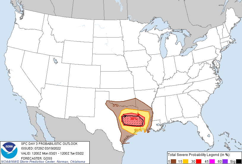
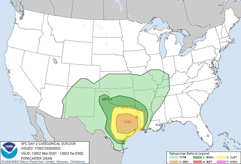
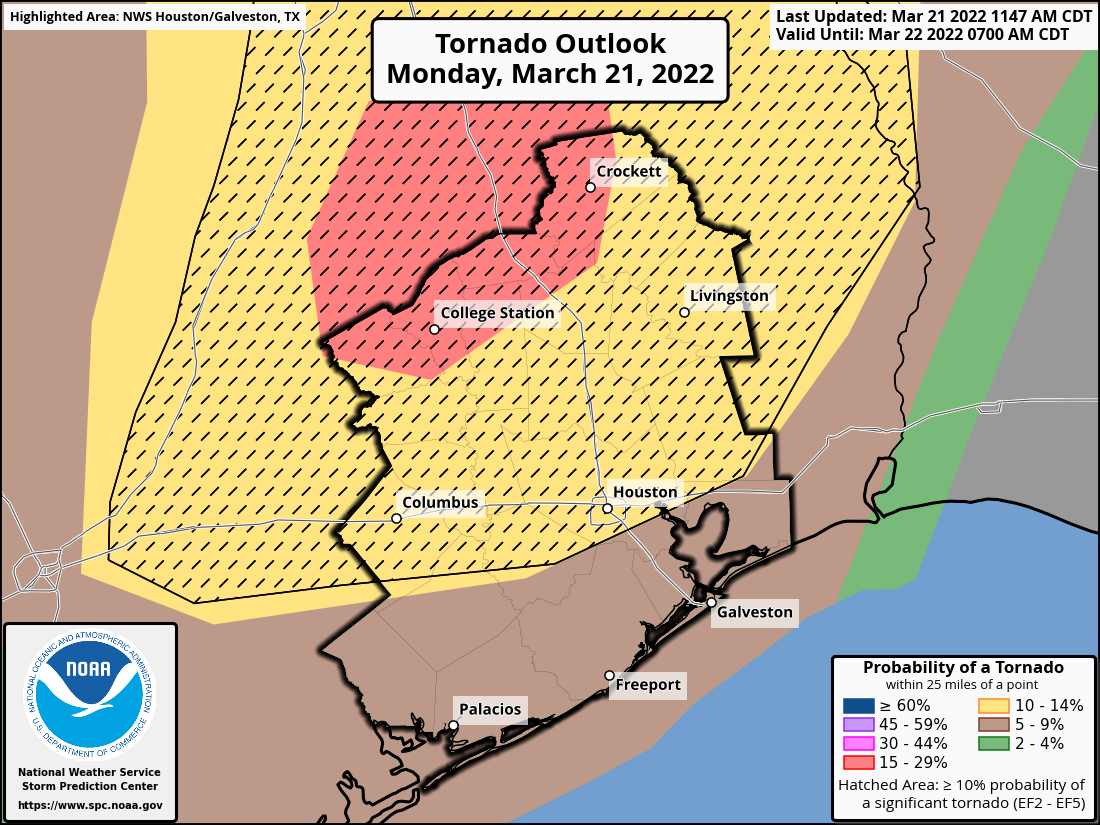
| SPC Day 3 Categorical Outlook | SPC Day 3 Probabilistic Outlook | SPC Day 2 Categorical Outlook | SPC Day 2 Tornado Outlook |
.png) |
 |
 |
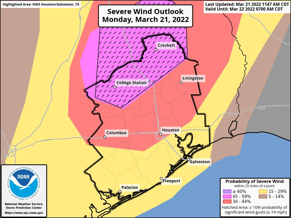 |
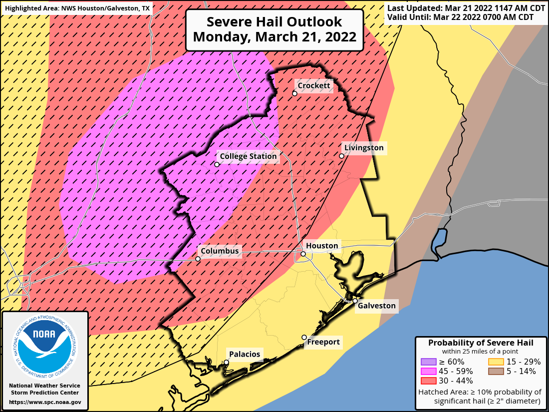
| SPC Day 1 Categorical Outlook | SPC Day 1 Tornado Outlook | SPC Day 1 Hail Outlook | SPC Day 1 Wind Outlook |
 |
 |
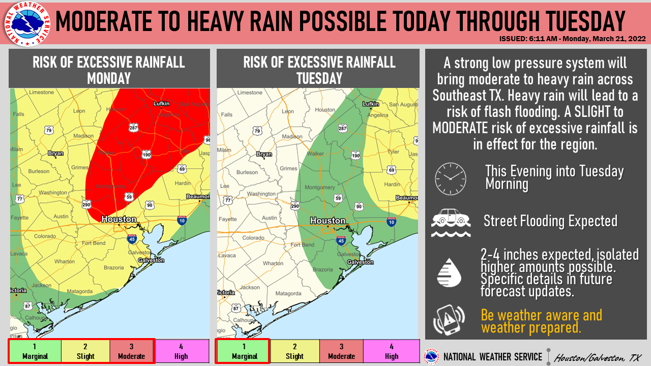 |
| Severe weather outlook | Severe weather outlook (spanish/espanol) | Excessive rain outlook |
 |
Media use of NWS Web News Stories is encouraged! Please acknowledge the NWS as the source of any news information accessed from this site. |
|