Houston/Galveston, TX
Weather Forecast Office
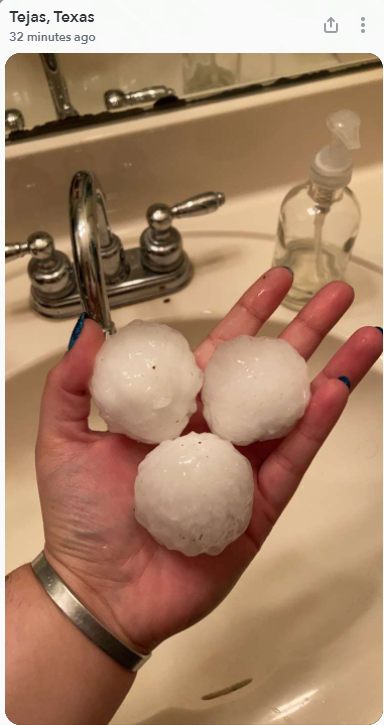
In the afternoon of April 8th, 2021, a singular thunderstorm developed in Comanche County, but quickly gained strength and began to produce large hail in northern Comanche County by 5pm. The thunderstorm split over Erath County at around 5:30pm as it progressed eastward. The weaker cell split to the north of the town of Hico and then eventually just south of Dallas before dying. The other cell moved south towards the Town of Waco strengthening into a long-lived Severe Thunderstorm dropping large hail as it went. It continued on this trajectory approaching the Burleson/Brazos County border around 8:30pm. The first Severe Thunderstorm Warning was issued at 8:39pm CDT for portions of Burleson, Brazos, and Grimes counties with the first report of hail falling in Brazos County at 8:50pm. The most significant hail in our area fell in Bryan-College Station area between 9:00 - 9:30pm CST where 1" to 2.75" (the size from a quarter to a baseball) fell. A Tornado Warning was issued as the storm moved over the College Station area due to radar-indicated circulation, though no tornado has been confirmed for this storm at the writing of this summary. The storm continued its southeastward motion into southern Grimes County before eventually dissipating in western Montgomery County at around 10:30pm CDT.
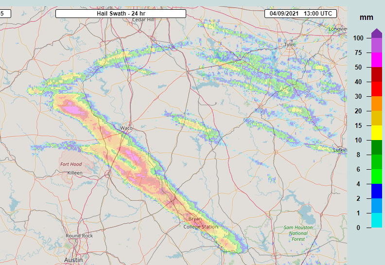
This image shows the MRMS track of the severe thunderstorm as it tracked across Central to Southeast Texas. The reds and pinks can be associated with where the larger hail fell.
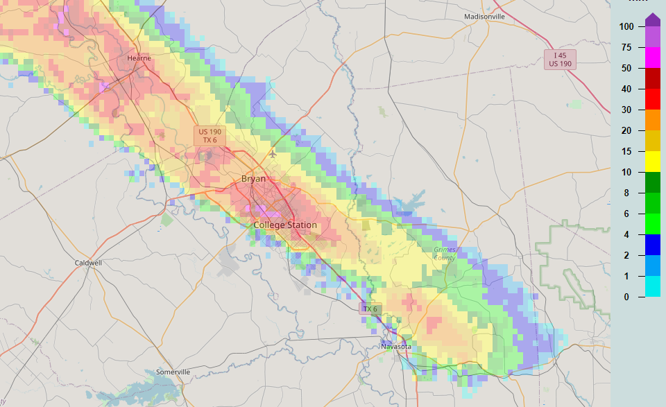
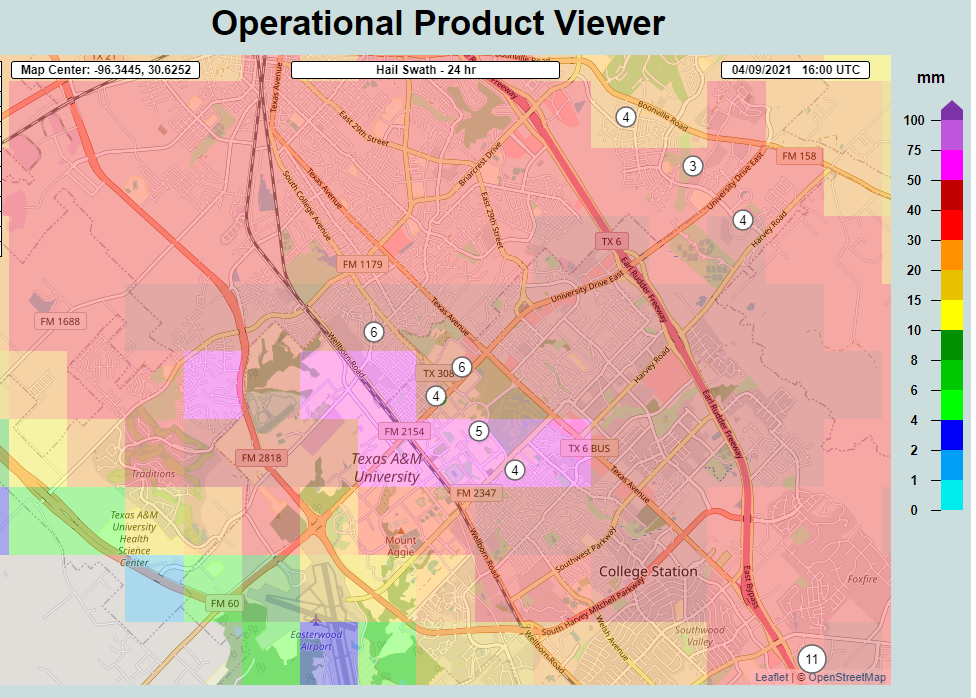
Zoomed in views of the hail swath over Bryan-College Station area.
Hail:
Hail
.jpg) |
.jpg) |
 |
.jpg) |
| Hail damage to window in Downtown Bryan. (via Twitter - A.J. Harrel) | Large hail in Bryan (via Twitter - Miriam & Anna Sanders) | Large hail found via Snapchat near Trejas/College Station | Pile of hail with quarter for reference in College Station (via Twitter - Ian Gunter) |
More pictures can be found in this article from KBTX.
The video below was taken from the Texas A&M Student Recreation Center by Manish Thakran.
Radar
Here is a radar loop from the KGRK Radar of the severe thunderstorm as it moved through the Brazos Valley.
Storm Reports
...HAIL REPORTS...
Location Size Time/Date Lat/Lon
4 WSW College Station 2.75 in 0915 PM 04/08 30.60N/96.38W
4 SE College Station 2.75 in 0927 PM 04/08 30.58N/96.28W
2 WNW College Station 1.50 in 0913 PM 04/08 30.63N/96.35W
1 WNW College Station 1.50 in 0918 PM 04/08 30.63N/96.34W
2 NNW UP403 1.25 in 0850 PM 04/08 30.70N/96.49W
1 WSW College Station 1.25 in 0919 PM 04/08 30.62N/96.34W
1 SSW College Station 1.00 in 0911 PM 04/08 30.61N/96.33W
3 NE College Station 1.00 in 0914 PM 04/08 30.65N/96.29W
1 W College Station 1.00 in 0921 PM 04/08 30.62N/96.34W
3 NNE College Station 1.00 in 0924 PM 04/08 30.66N/96.31W
Observations are collected from a variety of sources with varying
equipment and exposures. We thank all volunteer weather observers
for their dedication. Not all data listed are considered official.
$$
 |
Media use of NWS Web News Stories is encouraged! Please acknowledge the NWS as the source of any news information accessed from this site. |
|
CURRENT HAZARDS
-National Hurricane Center
-Storm Prediction Center
-Weather Prediction Center
-River Forecast Centers
-Aviation Weather Center
-Center Weather Service Units
-Spaceflight Meteorology Group
-Space Weather Prediction Center
CURRENT WEATHER
-Tides and Currents
-Observations
-Satellite
-Rainfall Reports
-Public Information Statement
-Galveston Beach Patrol (Flag Warning System)
FORECASTS
-Activity Planner
-Forecast Discussion
-Marine
-Tropical
-Aviation
-Fire
-Beach
-Models
-Drought
History
-Our Office
-National Weather Service
-NOAA
-Major Events
RADAR
-Houston/Galveston
-National
-Corpus Christi
-Lake Charles
-Austin/San Antonio
-Granger (Central Texas)
-Worldwide
-Education
Rivers/Lakes/Bayous
-Lower Colorado River Authority
-Harris County Flood Warning System
-Local
-National
-Jefferson County Drainage District 6
-Brazos River Authority
CLIMATE
-Houston Intercontinental
-Houston Hobby
-Galveston
-College Station
-Palacios
-Graphs
-Climate Summaries
-Local Data/Records
-Old Climate Page
-NCEI
-Storm Data
-Weather History
-Wind Roses
Education/Careers
-National Weather Service
-Careers
-Web Weather for Kids
-HGX Teacher Resources
-more
PREPAREDNESS/SAFETY
-Evacuation Planning
-Publications/Brochures
-StormReady
-2026 Hurricane Guide
-2026 Hurricane Guide (Spanish)
-SKYWARN Schedule
-FloodAware
-Weather Radio
-Evacuation ZipZone
-Evacuation Routes
-more
ADDITIONAL INFO
-Weather Ready Nation
-Weather Safety
-Severe Stats
-Air Now
-CoCoRaHS
-Miscellaneous Info
-Astronomical Info
-Frequent Products
-Find It Quick
-Watch, Warning, and Advisory Criteria
Tropical
-Preparedness Meetings
-Historical Tracks
-Education
-Climatology for SE TX
-Hurricane Harvey
-Hurricane Alicia
-Tropical Storm Imelda
-Local Page
US Dept of Commerce
National Oceanic and Atmospheric Administration
National Weather Service
Houston/Galveston, TX
1353 FM 646 Suite 202
Dickinson, TX 77539
281-337-5074
Comments? Questions? Please Contact Us.

