Houston/Galveston, TX
Weather Forecast Office
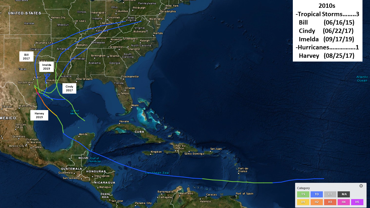
| NAME | CLASS / LANDFALL |
DATE | DATA (kts/mbs) |
AFFECTS |
|---|---|---|---|---|
| IMELDA | Tropical Storm/ Freeport |
9/17/19 | Pk. Wind - 40 kt Pressure - 1003 mb |
Produced historic rainfall totals of more than 40 inches that caused devastating flooding over portions of southeastern Texas after meandering to the north-northeast of the Houston area for a couple of days. |
| HARVEY | Hurricane - Cat. 4/ Rockport |
8/25/17 | Pk. Wind - 115 kt Pressure - 937 mb |
Dropped historic amounts of rainfall of more than 60 inches that caused catastrophic flooding over a very large portion of Southeast Texas after stalling over or near the Texas coast for four days. |
| CINDY | Tropical Storm/ Just east of Sabine Pass |
6/22/17 | Pk. Wind - 45 kt Pressure - 991 mb |
Produced heavy rainfall and river flooding, as well as some coastal flooding, over the northern Gulf coastal region. |
| BILL | Tropical Storm/ Matagorda Island |
6/16/15 | Pk. Wind - 50 kt Pressure - 997 mb |
Produced heavy flood-producing rainfall across parts of Southeast Texas and some storm surge flooding along the coast. |
CURRENT HAZARDS
-National Hurricane Center
-Storm Prediction Center
-Weather Prediction Center
-River Forecast Centers
-Aviation Weather Center
-Center Weather Service Units
-Spaceflight Meteorology Group
-Space Weather Prediction Center
CURRENT WEATHER
-Tides and Currents
-Observations
-Satellite
-Rainfall Reports
-Public Information Statement
-Galveston Beach Patrol (Flag Warning System)
FORECASTS
-Activity Planner
-Forecast Discussion
-Marine
-Tropical
-Aviation
-Fire
-Beach
-Models
-Drought
History
-Our Office
-National Weather Service
-NOAA
-Major Events
RADAR
-Houston/Galveston
-National
-Corpus Christi
-Lake Charles
-Austin/San Antonio
-Granger (Central Texas)
-Worldwide
-Education
Rivers/Lakes/Bayous
-Lower Colorado River Authority
-Harris County Flood Warning System
-Local
-National
-Jefferson County Drainage District 6
-Brazos River Authority
CLIMATE
-Houston Intercontinental
-Houston Hobby
-Galveston
-College Station
-Palacios
-Graphs
-Climate Summaries
-Local Data/Records
-Old Climate Page
-NCEI
-Storm Data
-Weather History
-Wind Roses
Education/Careers
-National Weather Service
-Careers
-Web Weather for Kids
-HGX Teacher Resources
-more
PREPAREDNESS/SAFETY
-Evacuation Planning
-Publications/Brochures
-StormReady
-2026 Hurricane Guide
-2026 Hurricane Guide (Spanish)
-SKYWARN Schedule
-FloodAware
-Weather Radio
-Evacuation ZipZone
-Evacuation Routes
-more
ADDITIONAL INFO
-Weather Ready Nation
-Weather Safety
-Severe Stats
-Air Now
-CoCoRaHS
-Miscellaneous Info
-Astronomical Info
-Frequent Products
-Find It Quick
-Watch, Warning, and Advisory Criteria
Tropical
-Preparedness Meetings
-Historical Tracks
-Education
-Climatology for SE TX
-Hurricane Harvey
-Hurricane Alicia
-Tropical Storm Imelda
-Local Page
US Dept of Commerce
National Oceanic and Atmospheric Administration
National Weather Service
Houston/Galveston, TX
1353 FM 646 Suite 202
Dickinson, TX 77539
281-337-5074
Comments? Questions? Please Contact Us.

