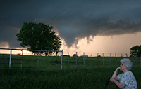
Spotters often observe amazing weather phenomena. Whether it is a tornado in the distance or ice taking down power lines, your local NWS Forecast Office learns a great deal from spotter photos and videos.
If you are willing to allow the NWS to use your photo or video in our education and outreach efforts, please state that NWS has permission to reprint when you submit the file to us. If you would like us to credit you on the image, we will gladly do that.
Multimedia files are a tremendous resource when conducting our spotter training courses and our weather safety education efforts.
The Citizen Weather Observer Program (CWOP) is a private-public partnership that allows people with computerized weather stations and always on Internet access to send their weather information to a special data server that collects weather observations from around the country.
Your data can then be used by computer forecast models to produce short term forecasts (3 to 12 hours into the future) of weather conditions in your region.
Visit http://wxqa.com to register for an ID and learn which weather stations and software packages work with the CWOP network.
Community Collaborative Rain, Hail and Snow Network (CoCoRaHS) is a unique non-profit, community-based network of volunteers of all ages and backgrounds working together to measure and map precipitation: rain, hail and snow.
By using low-cost measurement tools, stressing training and education, and accessing an interactive website, volunteers provide the highest quality data for natural resource, education and research applications.
The program is open to anyone who has an interest in weather and would like to share their precipitation data with others. Requirements of the program include:
To join the CoCoRaHS program, go to: http://www.cocorahs.org. The precipitation data is available for anyone to see online.
The NOAA National Severe Storms Laboratory (NSSL) is collecting public weather reports through a free app available for smart phones or mobile devices. The app is called mPING, for Meteorological Phenomena Identification Near the Ground.
Reports using the free mPING app are immediately archived into a database at The University of Oklahoma, and are displayed on a map accessible to anyone. This information is also relayed to local National Weather Service offices.
The free mPING app is available for both iOS and Android users. To use the app, reporters select the type of weather that is occurring, and tap submit. The anonymous reports can be submitted as often as every minute.

