All thunderstorms require the following three ingredients: moisture, lift, and instability. Organized severe thunderstorm events also require vertical wind shear
Simply put, water vapor (water in a gaseous form) condenses into tiny liquid droplets which comprises Cumulus clouds. These clouds are in a constant state of condensation and evaporation.
If the condensation rate exceeds the evaporation rate, the cloud grows and develops. Conversely, if evaporation exceeds condensation, the cloud dissipates.
The primary source of our moisture is warm tropical waters. This is because as temperature of water increases, the amount of water vapor released into the atmosphere increases.
The water temperature in the Western Atlantic Ocean and Gulf of America is higher than the Eastern Pacific Ocean. This is the reason for the much greater number of thunderstorms east of the Rockies as compared to the West coast of United States.
But moisture alone is not enough. Lift provides the mechanism for moist air to rise. As the air rises, it cools, leading to condensation and formation of clouds.
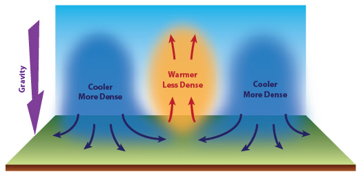
Perhaps surprisingly, the lifting mechanism depends upon gravity. Based upon the 2nd Law of Thermodynamics, warm moist air, which is of lower density than dry and cooler air, will not begin to move unless acted upon by another force.
Gravity initiates this force by pulling cooler, drier, and more dense air towards the Earth's surface. At the surface, this cooler air spreads out, undercuts the moist air begins to lift it up into the atmosphere.
We commonly see this as thunderstorms develop along cold fronts where the cold air undercuts warm air creating the lifting mechanism.
Dry air also has greater density that moist air. The boundary where the dry air undercuts moist air (dry line) is also a source of lift for thunderstorms.
In addition, air that is lifted due to topography, being forced up slopes of mountains, can lead the formation of thunderstorms.
Yet, a combined supply of atmospheric moisture and a source for lift can still not be sufficient for the formation of thunderstorms. The focus then is on the stability of the atmosphere.
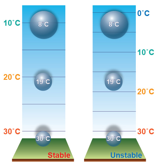
We all know the overall temperature of the atmosphere decreases with height. However the rate at which the temperature decreases with height varies from day-to-day.
A bubble of moist air (called a parcel), given an initial lift up, will continue to rise as long as its temperature remains higher than the temperature of the air surrounding the bubble. This refers to the buoyancy of the rising bubble.
Additionally, the greater the temperature difference between the bubble and surrounding air the faster the bubble will wise. When the bubble's temperature is higher than the surrounding air's temperature it is called an unstable atmosphere.
Conversely, stable conditions result when a lifted bubble of air becomes cooler than the surrounding air at that altitude. Because it is cooler, it is more dense and gravity therefore retards lift.
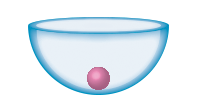
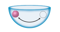
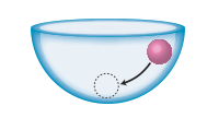
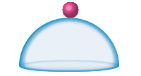
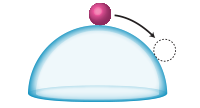
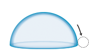
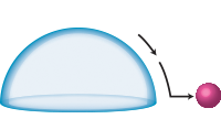
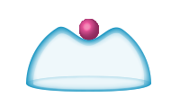
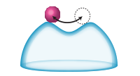
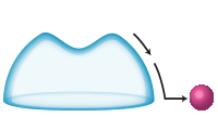
The following ball and bowl illustrations should help in understanding parcel stability and instability. The bowl represents the 'state' of the atmosphere. The red ball represents a "bubble" of air upon which an energy is applied to the ball to initiate motion.
With the ball inside of the bowl it will return to its initial position. In the atmosphere, if a parcel returns to its initial starting elevation then the atmosphere is considered to be absolutely stable.
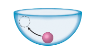
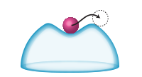
With the bowl turn upside down, the ball now rests on the top of the bowl. When a force is applied to the ball it begins to move on its own without any additional force applied. When this occurs in our atmosphere it is considered absolutely unstable.
Even though the overall temperature of the atmosphere decreases with height, there are many times with this is not the case. It is common to observe one or more layers of the atmosphere where the decrease in temperature, inverts and actually increases with height.
Called "inversions", these layers can inhibit a rising bubble. This is because the bubble rises into a region where its temperature become lower than the surrounding air's temperature and gravity's pull stops the bubble from rising further. In essence, inversions act to "cap" the atmosphere.
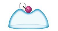
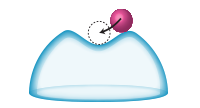
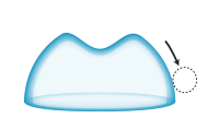
The upside down glass bowl has a slight depression wherein the ball rests. If the force is not too great the ball will return to its initial position similar to absolute stability. However if the force is strong enough the ball will move up and out of the depression and continue to move on its own. This is one of the most common states of the atmosphere called conditional instability. The atmosphere is unstable if certain conditions are met otherwise it is stable.
The strength of inversions often determine the intensity of storms. Early in the daytime hours, with a weak inversion, the bubble rising momentum carries it past the inversion fairly easy and therefore the potential temperature difference between it and the atmosphere and bubble is small. The end result is rising air earlier in the daytime but not a rapid rise. This is common in the tropics.
Compare that to a strong inversion. The inversion inhibits the bubble from rising for the better part of the day. But with continued daytime heating, more and more potential energy is added to the bubble until it reaches the point where its upward motion punches though the cap. Then, with a much larger temperature difference between it and the surrounding atmosphere, it rises extremely fast with any thunderstorm quickly becoming severe.
The temperature and moisture condition of the atmosphere is complex and is constantly changing. All three aspects of lift, moisture and stability, together determine when and where, if any, thunderstorms will develop.

