It is of upmost importance that you are aware of your location relative to the risk of severe weather in general and supercells in particular. Your location will determine both what you may be able to observe and your risk of injury.
Our desire first is for you to remain safe. Then, and only then, we want to know what you observe visually. We take your observations and compare it with what we see on radar to provide a better picture of the situation.
The local atmospheric wind environment around supercells is very chaotic and constantly changing. Do not assume what you see on your local radar app is a current "picture" of what you are observing.
The weather radar image only tells you WHAT HAS happened and NOT WHAT IS happening. The image you receive is often several minutes old. Help us by telling WHAT IS happening, visually, from your vantage point.
However, looping radar images are very good for helping discern a storm's motion. Knowing that, you then know if you need to move to a better vantage point or to take shelter.
The first danger to arrive from a supercell (for any thunderstorm for that matter) is lightning. DO NOT ASSUME you are safe from lighting by any preset distance from a thunderstorm.
If you hear thunder, you are in a high-risk area for lightning strikes. This can be especially true with lightning in the supercell's anvil.
Sometimes, thunder can be heard overhead in an anvil even though the parent storm may be over 15 miles (24 km) away. That sound is your warning to seek shelter indoors.
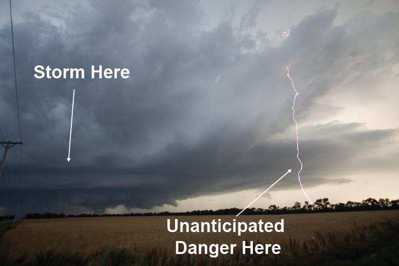
However, if there is no substantial shelter in the vicinity, your hard-topped vehicle can help to keep you safe. The metal in the roof and pillars of your vehicle help to create a Faraday cage and will help channel a direct lightning strike around the interior passenger area.
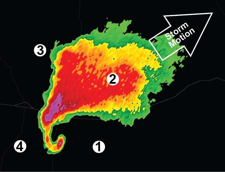
Pros: This is the ideal location. From this vantage point you have the best view of how the storm evolves. You can see the forward flank down draft on the right, the rain free base on the left, the location of the rear flank downdraft and any flanking line cumulus.
Also, there is usually good contrast between any developing tornado and the background lighter sky. Additionally, you are out of any threat of hail and can escape to the south should danger approach.
Cons: As seen in the image above, lightning strikes are a real possibility in this location. Also, careful observation is needed on the storms motion as the supercell can begin to move (or turn) to the right of upper level winds. A quickly increasing east or southeast wind could indicate a developing tornado.
Pros: None.
Cons: You are in the path of increasingly heavier rain which obscures your visibility. Should the storm continue toward your location, small hail could begin, but grow in size as the storm approaches.
Pros: You are out of the storm's path.
Cons: Heavy rain/hail will hinder your visibility of any tornado or other features in the storm's evolution. There is also a risk of the storm splitting into two updrafts.
If this occurs, the new storm moves to the left of the main storm's direction and toward your location. "Left movers" (the northern storm) are notorious for very large hail and much faster movement yet typically do not produce tornadoes.
Pros: You are out of the path of any tornado.
Cons: While you may have clear sight of any developing tornado, this is where the rear flank down draft winds can be fierce. Additionally, contrast between any tornado or funnel cloud will be low against the background rendering observing difficult.

